The Canadian Quaternary Association (CANQUA) Biennial Meeting is taking place at McGill University in Montreal, June 3-6, 2026.
Abstracts are due March 6th!
event.fourwaves.com/canqua2026/p...
If you work on geohazards, please consider submitting an abstract to our session:
23.02.2026 23:11 —
👍 5
🔁 1
💬 0
📌 0
This was a really fantastic team effort and it was fun to see it come together so fast in comparison to the usual pace of scientific writing (I guess we were excited!). More to come!
11.02.2026 22:46 —
👍 2
🔁 0
💬 0
📌 0

We also compiled a preliminary inventory of over 200 landslides along with other surface effects caused by the earthquake. Interestingly, despite there being some very large landslides, their areal distribution was considerably smaller than expected for an earthquake of this magnitude.
11.02.2026 22:46 —
👍 7
🔁 2
💬 1
📌 1

We applied double-difference relocation to the mainshock and 3280 aftershocks to illuminate the fault rupture geometry, and we explore the implications in terms of regional tectonics.
11.02.2026 22:46 —
👍 6
🔁 1
💬 1
📌 1
YEG2025_4 - The December 6, 2025 Mw 7.0 earthquake in Yukon, Canada: Tectonic significance and observations of ground failure - Publication Details - Yukon Geological Survey
Finley, T., Gosselin, J.M., Biegel, K.M., Lipovsky, P.S., Cronmiller, D.C., Schaeffer, A.J. and Dettmer, J., 2026. The December 6, 2025 Mw 7.0 earthquake in Yukon, Canada: Tectonic significance and observations of ground failure. In: Yukon Exploration and Geology 2025, A. Stuart, L.H. Weston and S.K. Schultz (eds.), Yukon Geological Survey, Government of Yukon, p. 131–148.. Abstract: The December 6, 2025 moment magnitude (Mw) 7.0 earthquake in southwestern Yukon was the largest onshore earthquake in Canada in over 75 years. It caused no casualties or damage to the built environment but offers insight into the complex active tectonics of the St. Elias orogen and hazards posed by major faults in the Yukon. It also caused widespread landslides and avalanche activity, providing an opportunity to study relationships between ground shaking and mass wasting. Here, we use double-difference relocation to refine the location of the mainshock and 3280 ensuing aftershocks. Based on satellite imagery and a reconnaissance flight to the epicentral area, we compile a preliminary inventory of over 200 landslides and other surface effects caused by the event. During the December 12, 2025 flight, no evidence of a surface rupture was observed. The areal extent of landslide occurrences was also considerably smaller than expected based on empirical data from past earthquakes, possibly due to the cold temperatures and presence of permafrost. The earthquake relocations and landslide distribution indicate that the main rupture and strongest shaking occurred beneath the Mt. King George massif. We infer that the rupture occurred on the southernmost section of the hypothesized Totschunda-Fairweather Connector fault. Slip initiated with strike-slip motion, rupturing northwestward, and may have activated a conjugate reverse fault toward the northwest segment of the rupture.
In response to the Dec. 6 Mw 7.0 earthquake in southwest Yukon, colleagues and I put together this short paper for the YGS's annual Yukon Exploration and Geology volume.
data.geology.gov.yk.ca/Reference/96...
11.02.2026 22:46 —
👍 4
🔁 3
💬 1
📌 0
Thanks for sharing this post - super interesting! We recently submitted a paper with a very similar theme, where we characterize a short fault scarp in the interior of the Canadian Cordillera. It's also a mature and slowly-deforming orogen with recent glaciation, making paleoseismology challenging!
15.01.2026 17:22 —
👍 4
🔁 0
💬 1
📌 0

Rock avalanche below Mt King George triggered by the 6 December 2025 Hubbard Glacier Earthquake. The runout distance is 1.4 km.
A sensational guest post by Derek Cronmiller, Theron Finley Panya Lipovsky and Jan Dettmer of the Yukon Geological Survey: Photos and Preliminary Observations from an Overview Flight of the 6 December 2025 Hubbard Glacier Earthquake, Yukon Territory, Canada.
eos.org/thelandslide...
05.01.2026 07:36 —
👍 89
🔁 39
💬 1
📌 6
We collected 100s of photos, hopefully enough to build rough 3D models with photogrammetry software. Good pre-event images may be hard to come by though
16.12.2025 14:37 —
👍 3
🔁 0
💬 2
📌 0
it’s certainly one benefit of living at this latitude. Days might be short but it’s golden hour all day!
16.12.2025 14:31 —
👍 5
🔁 0
💬 0
📌 0
It was a pretty incredible day at work this past Friday!
15.12.2025 23:19 —
👍 3
🔁 0
💬 0
📌 0

he first Sentinel1 images are in after the Alaskan M7 earthquake beneath Hubbard Glacier - no shortage of new landslides. Below are 28/11 and a 9/12 images! @watershedlab.bsky.social @davepetley.bsky.social
09.12.2025 09:33 —
👍 29
🔁 11
💬 4
📌 1
Thanks John :)
08.12.2025 17:40 —
👍 1
🔁 0
💬 0
📌 0
I was on CBC's Yukon Morning today speaking about Saturday's Hubbard Glacier M7.0 earthquake and its aftershocks.
Coincidentally, I got an audible alert on my phone for the M7.6 earthquake in Japan while we were on air!
www.cbc.ca/listen/live-...
08.12.2025 16:45 —
👍 26
🔁 7
💬 1
📌 0


Very preliminary relocation results from the December 6th #Alaska - #Yukon #earthquake, The Hubbard Glacier Earthquake. Double difference locations (343) derived from catalog epicentres (372), both manual and automatic. Squares are catalog epicentres, circles are relocations.
08.12.2025 07:38 —
👍 18
🔁 4
💬 1
📌 1

A USGS map of aftershocks (first 5 hours) show more than 60 located, some as large as M5.1. Coloured dots indicate the age of the events. These extend in a NW-SE direction along a 50-km-long fault.
Today's shallow M7 #earthquake near the Yukon-Alaska border has produced more than 60 #aftershocks (some as large as M5.1) during the first 5 hours.
Live #shaking from a seismic station at Haines Junction (YT) shows a steady stream of aftershocks:
www.earthquakescanada.nrcan.gc.ca/stndon/wf-fo...
⚒️🧪
07.12.2025 02:07 —
👍 35
🔁 16
💬 0
📌 0
A hypothesized fault connecting the Fairweather and Totshunda faults. It's evident in GNSS block models and seismicity patterns, but surface trace is obscured by the St. Elias icefield
06.12.2025 21:44 —
👍 4
🔁 0
💬 1
📌 1

Wow! 6.8 earthquake in Yukon near the border with Alaska! Shallow! Wondering if there is surface rupture? Or possibly landslides?
06.12.2025 20:56 —
👍 6
🔁 2
💬 1
📌 0
Pretty good shake here in Whitehorse. I didn’t feel it (I seemingly never do) but lots of other people did!
06.12.2025 21:09 —
👍 7
🔁 0
💬 4
📌 1
This is fantastic news!
23.07.2025 18:58 —
👍 3
🔁 1
💬 0
📌 0
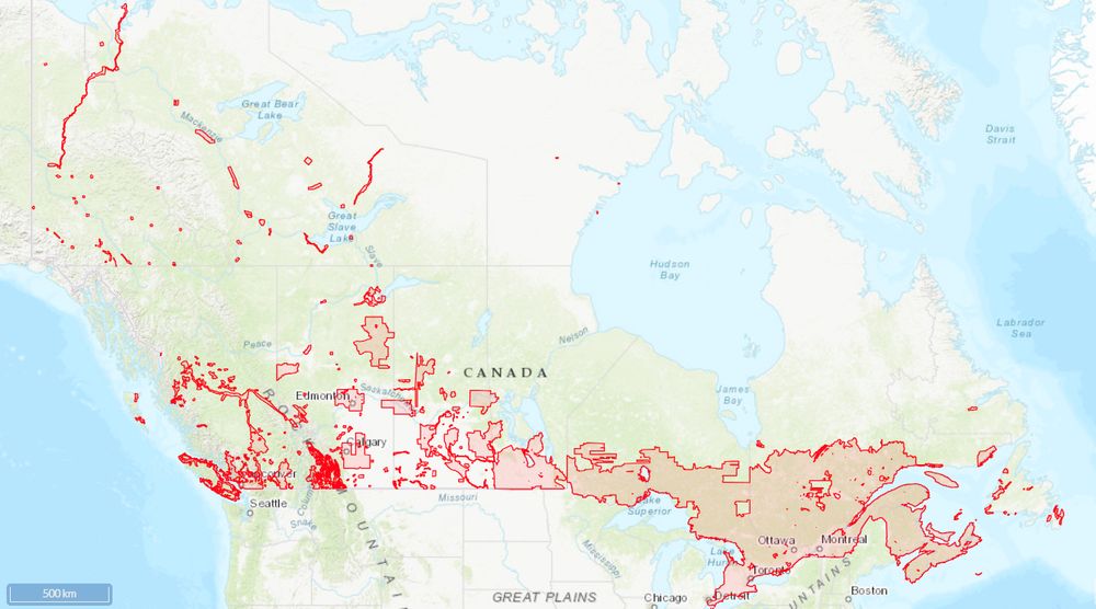
Map showing extent of data coverage, primarily over southern Canada
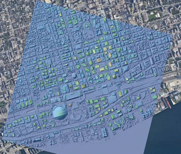
A hillshade colored by elevation of downtown Toronto draped on Google Earth imagery.
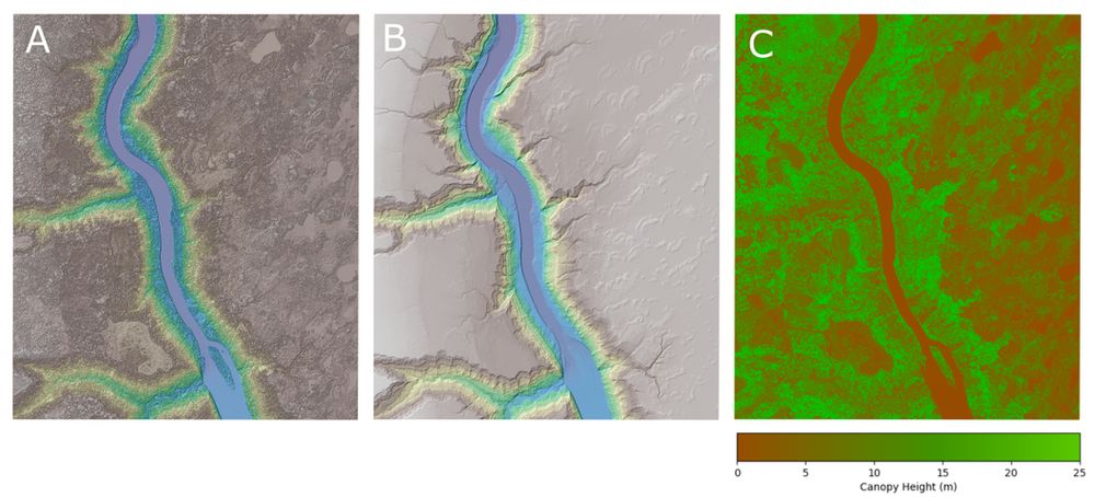
A three panel figure of a section of the Athabasca River in Alberta. Figure A is the Digital Surface Model which includes buildings, trees and other structures. Figure B is the Digital Terrain Model and is a bare-earth representation of the topography. Figure C is the Canopy Height Model (CHM) which is the difference between the DSM and the DTM.
OpenTopography is excited to announce a major expansion to its international data catalog with the addition of the High Resolution Digital Elevation Model from Natural Resources Canada. This 1-meter resolution dataset is ideal for a wide range of applications.
opentopography.org/news/opentop...
23.07.2025 14:35 —
👍 12
🔁 10
💬 0
📌 1
Thanks Britta! I’m headed up in two weeks and also can’t wait. The Yukon is truly the best!
18.07.2025 04:10 —
👍 1
🔁 0
💬 0
📌 0
Glad you find it helpful, Jeff! Lots more work to do, now that we know this hazard exists.
17.07.2025 19:15 —
👍 2
🔁 0
💬 1
📌 0
Indeed! I'm always amazed at the prescience of previous researchers, and it's great to be able to prove some of these hypotheses now that we have better data (ArcticDEM and lidar). Mortensen and Von Gaza speculated about these lineaments back in 1992(!) in an somewhat obscure YGS report!
17.07.2025 19:12 —
👍 1
🔁 0
💬 0
📌 0
Certainly! The main point we were making here is that old, mature faults like this that were likely much more active in the past, and played a major role in the development of the Cordillera, still persist as crustal weaknesses and seismic hazards.
17.07.2025 18:02 —
👍 1
🔁 0
💬 0
📌 0
Yes, the majority of the Canadian landmass, including BC, was covered by ice during the last glaciation. The southern ice limit was in the northernmost United States. Only northwest Yukon (and broader region extending across northern Alaska) remained ice free.
17.07.2025 17:34 —
👍 1
🔁 0
💬 0
📌 0
Also, in the rest of Canada where the landscape is much younger, evidence of this sort of fault activity would be largely erased, highlighting a preservation problem in the paleoseismic record.
17.07.2025 17:09 —
👍 5
🔁 1
💬 0
📌 0
More broadly these results highlight the seismic hazard of mature, low‐slip‐rate intraplate faults in orogenic belts, which may have very long recurrence intervals and elude detection via instrumental networks.
17.07.2025 17:09 —
👍 6
🔁 1
💬 1
📌 1

Satellite imagery map showing Dawson City, the location of the Moosehide Slide immediately of town, and the location of the Sunnydale landslide west of town across the Yukon River.
For example, this figure from Bodtker et al (2022) shows the position of the Moosehide and Sunnydale landslides above Dawson City.
17.07.2025 17:09 —
👍 4
🔁 0
💬 1
📌 0
A large rupture on the Tintina fault would cause significant shaking in the Klondike region, potentially damaging buildings, highways, and mining infrastructure. Compounding the hazard from seismic shaking, the region is prone to landslides, which could be seismically triggered.
17.07.2025 17:09 —
👍 5
🔁 1
💬 1
📌 0
Notably, 12,000 year old landforms are not offset across the fault, which implies that it may be at a relatively late stage of an interseismic period, having accrued a slip deficit of ~6 m. From this, we estimate that ruptures of at least magnitude 7.5 are possible in the future.
17.07.2025 17:09 —
👍 6
🔁 2
💬 1
📌 0