OTX issues Area Forecast Discussion (AFD) at Aug 6, 12:57 AM PDT
at Wed, 06 Aug 2025 07:58:02 +0000 via IEMbot
Additional Details Here.
06.08.2025 08:07 — 👍 0 🔁 0 💬 0 📌 0
OTX issues Area Forecast Discussion (AFD) at Aug 5, 10:43 PM PDT
at Wed, 06 Aug 2025 05:43:12 +0000 via IEMbot
Additional Details Here.
06.08.2025 05:47 — 👍 0 🔁 0 💬 0 📌 0
WENATCHEE WA PANGBORN FIELD Aug 5
Climate Report:
High: 85
Low: 64
Precip: 0.0"
Snow: Missing
at Wed, 06 Aug 2025 04:52:02 +0000 via IEMbot
Additional Details Here.
06.08.2025 05:07 — 👍 0 🔁 0 💬 0 📌 0
SPOKANE WA AIRPORT Aug 5
Climate Report:
High: 81
Low: 55
Precip: 0.0"
Snow: Missing
at Tue, 05 Aug 2025 23:51:58 +0000 via IEMbot
Additional Details Here.
06.08.2025 00:08 — 👍 2 🔁 0 💬 0 📌 0
WENATCHEE WA PANGBORN FIELD Aug 5
Climate Report:
High: 84
Low: 64
Precip: 0.0"
Snow: Missing
at Tue, 05 Aug 2025 23:51:58 +0000 via IEMbot
Additional Details Here.
06.08.2025 00:08 — 👍 0 🔁 0 💬 0 📌 0
OTX issues Area Forecast Discussion (AFD) at Aug 5, 3:46 PM PDT
at Tue, 05 Aug 2025 22:46:39 +0000 via IEMbot
Additional Details Here.
05.08.2025 22:47 — 👍 0 🔁 0 💬 0 📌 0
OTX issues Area Forecast Discussion (AFD) at Aug 5, 2:44 PM PDT
at Tue, 05 Aug 2025 21:45:17 +0000 via IEMbot
Additional Details Here.
05.08.2025 21:47 — 👍 0 🔁 0 💬 0 📌 0
OTX issues Area Forecast Discussion (AFD) at Aug 5, 11:36 AM PDT
at Tue, 05 Aug 2025 18:37:00 +0000 via IEMbot
Additional Details Here.
05.08.2025 18:47 — 👍 0 🔁 0 💬 0 📌 0
OTX issues Area Forecast Discussion (AFD) at Aug 5, 2:06 AM PDT
at Tue, 05 Aug 2025 09:06:42 +0000 via IEMbot
Additional Details Here.
05.08.2025 09:07 — 👍 0 🔁 0 💬 0 📌 0
PULLMAN_MOSCOW AIRPORT Aug 4
Climate Report:
High: 76
Low: 49
Precip: 0.0"
Snow: Missing
at Tue, 05 Aug 2025 08:27:59 +0000 via IEMbot
Additional Details Here.
05.08.2025 08:47 — 👍 0 🔁 0 💬 0 📌 0
EPHRATA WA AIRPORT Aug 4
Climate Report:
High: 85
Low: 57
Precip: 0.0"
Snow: Missing
at Tue, 05 Aug 2025 08:28:00 +0000 via IEMbot
Additional Details Here.
05.08.2025 08:47 — 👍 0 🔁 0 💬 0 📌 0
The Storm Prediction Center issues Day 3 Marginal Convective Risk at Aug 5, 7:29z for portions of OTX
at Tue, 05 Aug 2025 07:30:18 +0000 via IEMbot
Additional Details Here.
05.08.2025 07:47 — 👍 0 🔁 0 💬 0 📌 0
OTX issues Area Forecast Discussion (AFD) at Aug 4, 10:38 PM PDT
at Tue, 05 Aug 2025 05:39:43 +0000 via IEMbot
Additional Details Here.
05.08.2025 05:47 — 👍 0 🔁 0 💬 0 📌 0
WENATCHEE WA PANGBORN FIELD Aug 4
Climate Report:
High: 86
Low: 64
Precip: 0.0"
Snow: Missing
at Tue, 05 Aug 2025 04:52:11 +0000 via IEMbot
Additional Details Here.
05.08.2025 05:07 — 👍 0 🔁 0 💬 0 📌 0
OTX expires Flood Advisory for Okanogan [WA]
at Tue, 05 Aug 2025 03:25:41 +0000 via IEMbot
Additional Details Here.
05.08.2025 03:27 — 👍 0 🔁 0 💬 0 📌 0
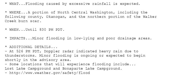
* WHAT...Flooding caused by excessive rainfall is expected.
* WHERE...A portion of North Central Washington, including the
following county, Okanogan, and the northern portion of the Walker
Creek burn scar.
* WHEN...Until 830 PM PDT.
* IMPACTS...Minor flooding in low-lying and poor drainage areas.
* ADDITIONAL DETAILS...
- At 526 PM PDT, Doppler radar indicated heavy rain due to
thunderstorms. Minor flooding is ongoing or expected to begin
shortly in the advisory area.
- Some locations that will experience flooding include...
Lost Lake Campground and Bonaparte Lake Campground.
- http://www.weather.gov/safety/flood
Flood Advisory issued August 4 at 5:26PM PDT until August 4 at 8:30PM PDT by NWS Spokane WA
Additional Details Here.
05.08.2025 00:30 — 👍 0 🔁 0 💬 0 📌 0
OTX issues Flood Advisory for Okanogan [WA] till Aug 4, 8:30 PM PDT
at Tue, 05 Aug 2025 00:27:04 +0000 via IEMbot
Additional Details Here.
05.08.2025 00:27 — 👍 0 🔁 0 💬 0 📌 0
SPOKANE WA AIRPORT Aug 4
Climate Report:
High: 74
Low: 58
Precip: 0.0"
Snow: Missing
at Mon, 04 Aug 2025 23:52:07 +0000 via IEMbot
Additional Details Here.
05.08.2025 00:07 — 👍 1 🔁 0 💬 0 📌 0
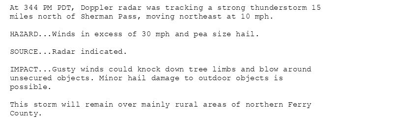
At 344 PM PDT, Doppler radar was tracking a strong thunderstorm 15
miles north of Sherman Pass, moving northeast at 10 mph.
HAZARD...Winds in excess of 30 mph and pea size hail.
SOURCE...Radar indicated.
IMPACT...Gusty winds could knock down tree limbs and blow around
unsecured objects. Minor hail damage to outdoor objects is
possible.
This storm will remain over mainly rural areas of northern Ferry
County.
Special Weather Statement issued August 4 at 3:44PM PDT by NWS Spokane WA
Additional Details Here.
04.08.2025 23:00 — 👍 1 🔁 0 💬 0 📌 0
OTX issues A strong thunderstorm will impact portions of northern Ferry County through 415 PM PDT [wind: 30 MPH, hail: 0.25 IN] for Okanogan Highlands [WA]
at Mon, 04 Aug 2025 22:45:16 +0000 via IEMbot
Additional Details Here.
04.08.2025 22:47 — 👍 0 🔁 0 💬 0 📌 0
OTX issues A strong thunderstorm will impact portions of northern Ferry County through 345 PM PDT [wind: 30 MPH, hail: 0.25 IN] for Okanogan Highlands [WA]
at Mon, 04 Aug 2025 22:09:46 +0000 via IEMbot
Additional Details Here.
04.08.2025 22:27 — 👍 0 🔁 0 💬 0 📌 0
OTX issues Area Forecast Discussion (AFD) at Aug 4, 3:18 PM PDT
at Mon, 04 Aug 2025 22:18:41 +0000 via IEMbot
Additional Details Here.
04.08.2025 22:27 — 👍 0 🔁 0 💬 0 📌 0
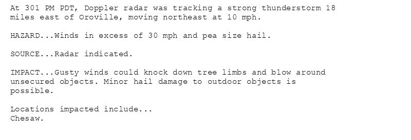
At 301 PM PDT, Doppler radar was tracking a strong thunderstorm 18
miles east of Oroville, moving northeast at 10 mph.
HAZARD...Winds in excess of 30 mph and pea size hail.
SOURCE...Radar indicated.
IMPACT...Gusty winds could knock down tree limbs and blow around
unsecured objects. Minor hail damage to outdoor objects is
possible.
Locations impacted include...
Chesaw.
Special Weather Statement issued August 4 at 3:02PM PDT by NWS Spokane WA
Additional Details Here.
04.08.2025 22:15 — 👍 0 🔁 0 💬 0 📌 0

At 309 PM PDT, Doppler radar was tracking a strong thunderstorm 15
miles north of Sherman Pass, moving northeast at 5 mph.
HAZARD...Winds in excess of 30 mph and pea size hail.
SOURCE...Radar indicated.
IMPACT...Gusty winds could knock down tree limbs and blow around
unsecured objects. Minor hail damage to outdoor objects is
possible.
This storm will remain over mainly rural areas of northern Ferry
County.
Special Weather Statement issued August 4 at 3:09PM PDT by NWS Spokane WA
Additional Details Here.
04.08.2025 22:15 — 👍 0 🔁 0 💬 0 📌 0
OTX issues A strong thunderstorm will impact portions of northeastern Okanogan County through 330 PM PDT [wind: 30 MPH, hail: 0.25 IN] for Okanogan Highlands [WA]
at Mon, 04 Aug 2025 22:02:46 +0000 via IEMbot
Additional Details Here.
04.08.2025 22:07 — 👍 0 🔁 0 💬 0 📌 0
OTX issues A strong thunderstorm will impact portions of eastern Okanogan County through 300 PM PDT [wind: 30 MPH, hail: 0.25 IN] for Okanogan Highlands [WA]
at Mon, 04 Aug 2025 21:32:25 +0000 via IEMbot
Additional Details Here.
04.08.2025 21:47 — 👍 0 🔁 0 💬 0 📌 0

At 231 PM PDT, Doppler radar was tracking a strong thunderstorm 19
miles northeast of Tonasket, moving northeast at 10 mph.
HAZARD...Winds in excess of 30 mph and pea size hail.
SOURCE...Radar indicated.
IMPACT...Gusty winds could knock down tree limbs and blow around
unsecured objects. Minor hail damage to outdoor objects is
possible.
Locations impacted include...
Lost Lake Campground and Bonaparte Lake Campground.
Special Weather Statement issued August 4 at 2:32PM PDT by NWS Spokane WA
Additional Details Here.
04.08.2025 21:45 — 👍 0 🔁 0 💬 0 📌 0
OTX issues A strong thunderstorm will impact portions of northwestern Bonner and northeastern Pend Oreille Counties through 215 PM PDT [wind: 30 MPH, hail: 0.50 IN] for Northern P... at Mon, 04 Aug 2025 20:40:31 +0000 via IEMbot
Additional Details Here.
04.08.2025 20:47 — 👍 0 🔁 0 💬 0 📌 0
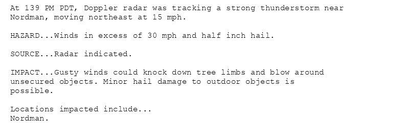
At 139 PM PDT, Doppler radar was tracking a strong thunderstorm near
Nordman, moving northeast at 15 mph.
HAZARD...Winds in excess of 30 mph and half inch hail.
SOURCE...Radar indicated.
IMPACT...Gusty winds could knock down tree limbs and blow around
unsecured objects. Minor hail damage to outdoor objects is
possible.
Locations impacted include...
Nordman.
Special Weather Statement issued August 4 at 1:40PM PDT by NWS Spokane WA
Additional Details Here.
04.08.2025 20:45 — 👍 0 🔁 0 💬 0 📌 0

At 140 PM PDT, Doppler radar was tracking a strong thunderstorm near
Nordman, moving northeast at 15 mph.
HAZARD...Winds in excess of 30 mph and half inch hail.
SOURCE...Radar indicated.
IMPACT...Gusty winds could knock down tree limbs and blow around
unsecured objects. Minor hail damage to outdoor objects is
possible.
Locations impacted include...
Nordman.
Special Weather Statement issued August 4 at 1:40PM PDT by NWS Spokane WA
Additional Details Here.
04.08.2025 20:45 — 👍 0 🔁 0 💬 0 📌 0