
Egypt Landcover 2024
🗺️Map showing Egypt Land Cover – 2024🇪🇬
Made with QGIS & Blender using:
🏞️Landcover from EarthMap(ESRI 2024)
⛰️ DEM from Elevatr Library in R programming
#Egypt #Africa #QGIS #Blender #b3d #data #Cartography #GIS #gischat #LandCover #map
26.10.2025 06:35 — 👍 0 🔁 0 💬 0 📌 0

Switzerland Landcover 2024
🗺️Map showing Switzerland Land Cover – 2024🇨🇭
Made with QGIS & Blender using:
🏞️Landcover from EarthMap (ESRI 2024)
⛰️ DEM from Elevatr R
#Switzerland #Europe #QGIS #Blender #b3d #data #Cartography #GIS #gischat #LandCover #map
25.10.2025 15:57 — 👍 1 🔁 0 💬 0 📌 0

Germany Land cover Map 2024
🗺️ Map showing Germany Land Cover – 2024
Made with QGIS & Blender using:
🏞️ Landcover from EarthMap (ESRI 2024)
⛰️ DEM from Divagis
#Germany #Europe #QGIS #Blender #b3d #data #Cartography #GIS #gischat #LandCover #map
24.10.2025 17:07 — 👍 3 🔁 1 💬 0 📌 0

Landcover Map of Mexico
🗺️ Map showing Mexico Land Cover – 2024 🇲🇽
Made with QGIS & Blender using:
🏞️ Landcover from EarthMap (ESRI 2024)
⛰️ DEM from Divagis
#Mexico #CDMX #NorthAmerica #QGIS #Blender #b3d #data #Cartography #GIS #gischat #LandCover #map
23.10.2025 14:59 — 👍 4 🔁 0 💬 0 📌 0

2026 Calendar Submissions - GeoHipster
Submit a calendar for the 2026 calendar year by october. Fame and Fortune (there is no fortune) await.
Geohipster Calendar - Submissions extended unto 10/23/2025 - Submit a map and and keep the longest running geo calendar going! www.geohipster.com/2025/07/30/2... #qgis #esri #foss4g #arcpro
16.10.2025 16:09 — 👍 2 🔁 1 💬 1 📌 0

Map showing Landcover of Uganda - 2024
🗺️Map showing Uganda Land Cover – 2024
Made with QGIS & Blender using:
🏞️Landcover from EarthMap (ESRI 2024)
⛰️DEM from Divagis
#Uganda #EastAfrica #Africa #QGIS #Blender #b3d #data #Cartography #gischat #LandCover #map
14.10.2025 16:38 — 👍 4 🔁 2 💬 0 📌 0
Original post on fosstodon.org
Update on QGIS 4.0 Release Schedule and LTR Plans
Following the earlier announcement that QGIS is moving to Qt 6 and launching QGIS 4.0, we want to share an important update about the QGIS 4.x roadmap. After extensive discussion on the developer mailing list, the QGIS community has agreed to […]
07.10.2025 21:24 — 👍 12 🔁 4 💬 0 📌 2

South America Landcover Map
🌎 South America Landcover Map 2024 🌳🏜️
From the Amazon rainforest (a vital carbon sink) to the Atacama Desert, this map shows how nature & human activity shape the continent:
#SouthAmerica #Landcover #qgis #b3d #blender #gischat
26.09.2025 17:33 — 👍 5 🔁 0 💬 0 📌 0
Editing mode in QGIS can be really useful. Here we look at how to add a new field to an attribute table, fill in some values and style our layer thematically with the new values. To do this we use…
Add a new field to attribute table in QGIS | burdGIS
Add a new field to an attribute table in #QGIS
24.09.2025 08:34 — 👍 2 🔁 1 💬 0 📌 0
Thanks
07.09.2025 17:33 — 👍 0 🔁 0 💬 0 📌 0

Tanzania Potential Vegetation Map
🗺️ Map showing Tanzania – Potential Natural Vegetation 🌍
Made with QGIS & Blender using:
🌱 Vegetationmap4Africa (EcoDiv.earth)
🏔️ DIVA-GIS DEM Data
Credit: @ecodiv.bsky.social
#Tanzania #VegetationMap #QGIS #Blender #Cartography #OpenData #Biodiversity #EcodivEarth #FOSS4G
05.09.2025 17:42 — 👍 8 🔁 2 💬 1 📌 1

Africa Landcover 2024
🗺️ Map showing Africa Land Cover – 2024 🌍 Made with QGIS & Blender using:
🌱 ESRI Land Cover Data
🏔️ GEBCO DEM Data
#Africa #LandCover #QGIS #Blender #gischat #Map #Cartography
31.08.2025 18:16 — 👍 8 🔁 0 💬 0 📌 0
Maps by MicheleTobias
It's a plugin for QGIS that allows you to store geographic locations in your Zotero citation metadata and lets you make maps of your the papers you put in Zotero.
Docs: micheletobias.github.io/maps/Literat...
GitHub: github.com/MicheleTobia...
Proof-of-Concept: journals.sagepub.com/doi/full/10....
28.08.2025 21:29 — 👍 5 🔁 2 💬 2 📌 0

So for the past month (or so) i have been designing a map based on various places that I have traveled to in Colorado in 2025. I am not currently looking for feedback ( that will come) I just want to relish in the enjoyment of having completed a map in QGIS and Adobe Illustrator #GISChat #MapSky
21.08.2025 14:16 — 👍 28 🔁 1 💬 3 📌 0
QGIS Training Manual — QGIS Documentation documentation
QGIS 3.40 documentation: QGIS Training Manual
I'd personally suggest ESRI's MOOCs (www.esri.com/training/mooc). I know, weird choice right? But, I found the knowledge I gained there transferable to how I used QGIS.
Alternatively, I'd have to refer to QGIS training manual and tutorials:
docs.qgis.org/3.40/en/docs...
www.qgistutorials.com/en
22.08.2025 18:37 — 👍 5 🔁 3 💬 0 📌 0
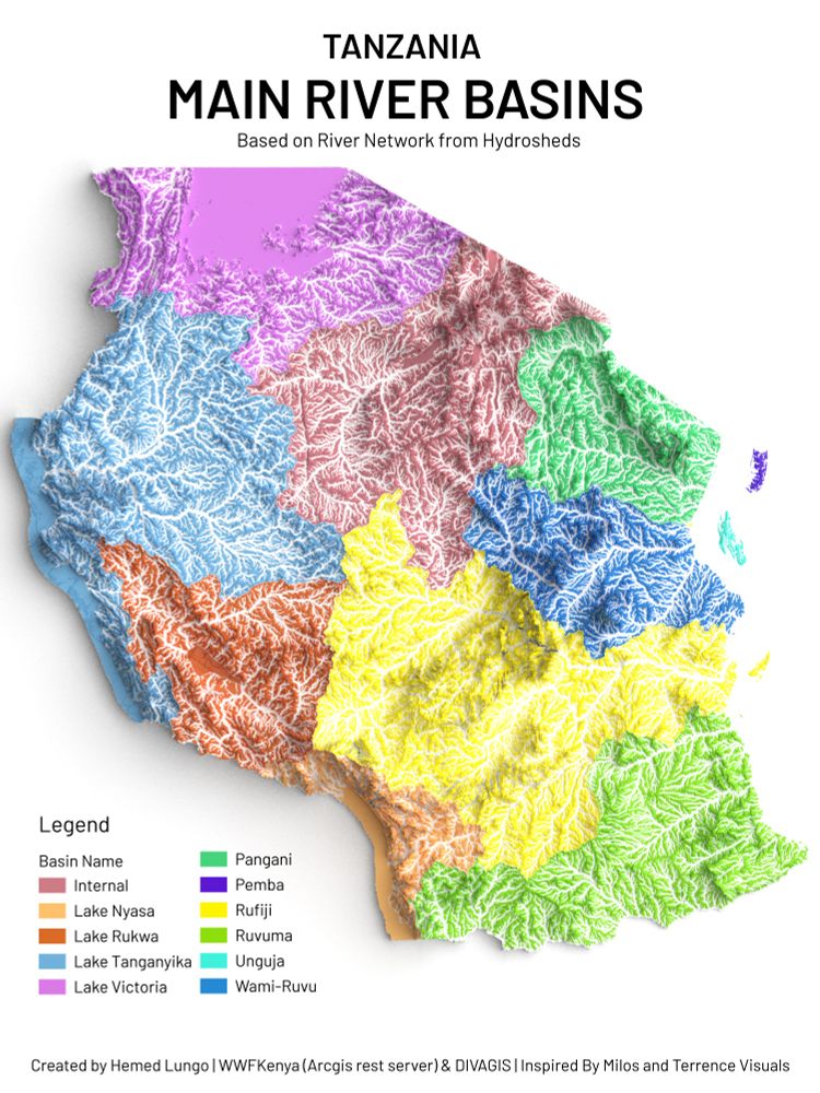
Tanzania River Basin
🗺️Tanzania River Basins 🇹🇿
Made with QGIS & Blender using:
(💧 HydroSHEDS,WWF 🏔️ DEM from DivaGIS)
A detailed look at Tanzania’s waterways from Lake Victoria & Tanganyika to Rufiji, Pangani, Ruvuma, and island basins of Unguja & Pemba.
#Tanzania #Africa #QGIS #Blender #gischat
10.08.2025 15:57 — 👍 2 🔁 2 💬 0 📌 0
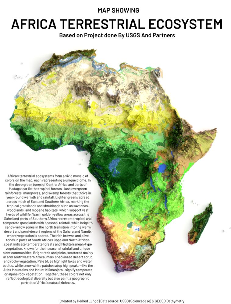
Terrestrial Ecosystem of Africa
A Map🗺️ Showing Terrestrial Ecosystem of Africa Continent , Dataset is from USGS (ScienceBase) #Africa #EastAfrica #WestAfrica #SouthAfrica #NorthAfrica #Soil #Soiltype #geology #map #dataviz #gischat #geospatial #dataviz #qgis #b3d #Blender #USGS
09.08.2025 18:09 — 👍 6 🔁 4 💬 0 📌 0
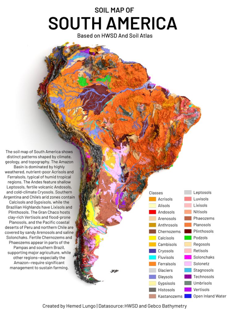
Soil Types of South America Continent
A Map🗺️Showing Soil Types of South America Continent , Dataset is from HWSD and GEBCO Bathymetry #SouthAmerica #LatinAmerica #Soil #Soiltype #geology #map #dataviz #gischat #geospatial #dataviz #qgis #b3d #Blender
08.08.2025 16:38 — 👍 3 🔁 1 💬 0 📌 0
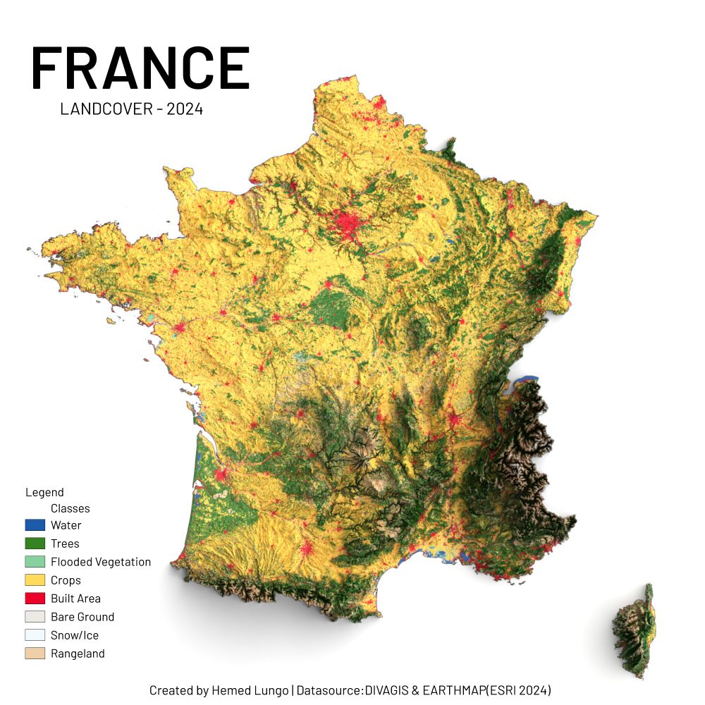
France Landcover – 2024
🗺️ France Landcover – 2024 🇫🇷
Réalisée avec QGIS & Blender à l’aide de :
🌱 ESRI Land Cover (2024)
🏔️ DEM de DivaGIS
Un aperçu éclatant des paysages français : forêts, cultures, montagnes, rivières et zones urbaines en expansion.
#France #Europe #QGIS #Blender #data #gischat #map
07.08.2025 19:36 — 👍 6 🔁 2 💬 0 📌 0
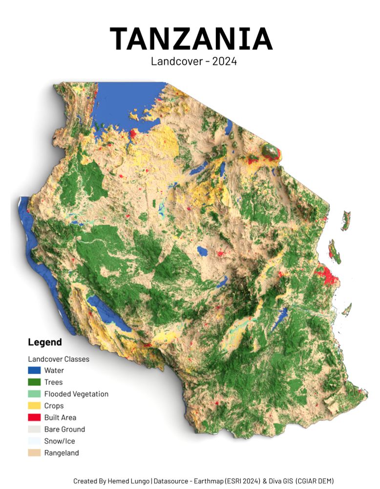
🗺️Tanzania Landcover – 2024🇹🇿
🗺️Tanzania Landcover – 2024🇹🇿
Made with QGIS & Blender using:
🌱 ESRI Land Cover Data (2024)
🏔️ DEM from DivaGIS
A vivid look at Tanzania’s diverse landscapes: from lush forests and croplands to shimmering lakes and growing urban zones. #Tanzania #Africa #QGIS #Blender #gischat
02.08.2025 23:16 — 👍 6 🔁 1 💬 1 📌 0
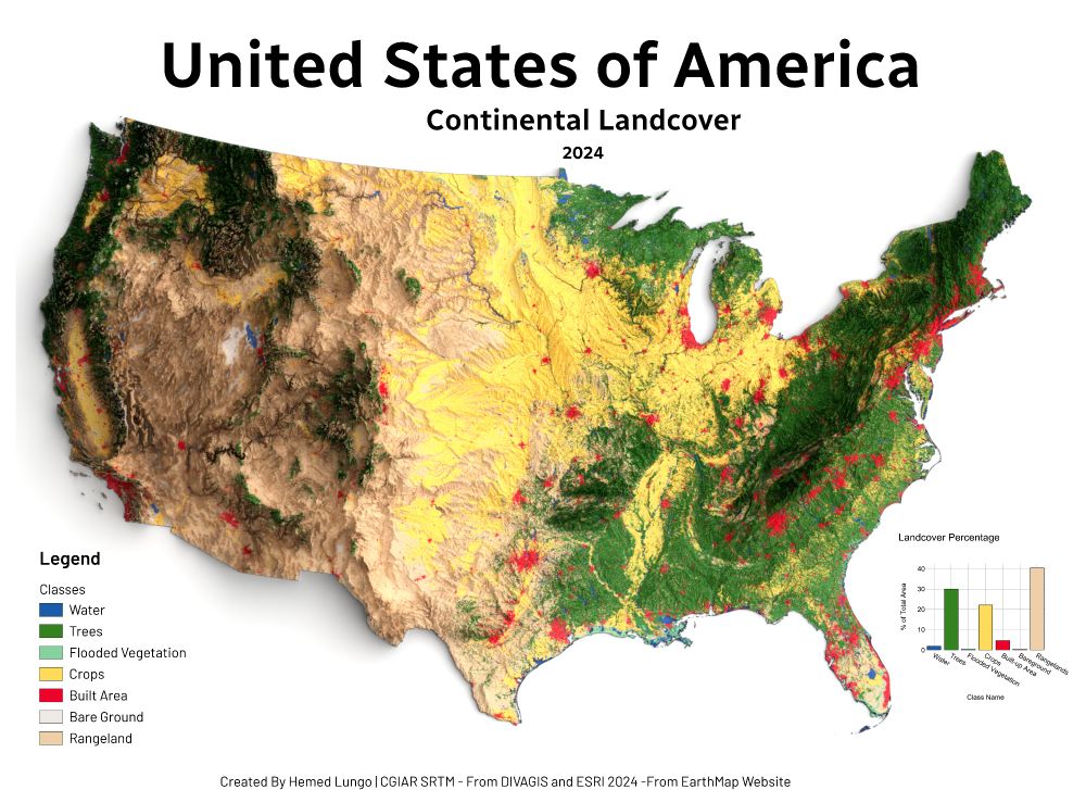
Landcover Map of U.S.A 2024
🗺️ USA Land Cover Map – 2024 🇺🇸
Made with QGIS & Blender using:
🌱 ESRI Land Cover (EarthMap)
🏔️ DEM from DivaGIS (CGIAR SRTM)
Forests, croplands, wetlands & cities — mapped to show the patterns shaping America's surface.
#USA #LandCover #QGIS #Blender #Cartography #GISChat #RemoteSensing #Map #OpenData
23.07.2025 19:41 — 👍 7 🔁 4 💬 0 📌 0
Thank you Hugh 😄🙏
20.07.2025 12:18 — 👍 1 🔁 0 💬 0 📌 0
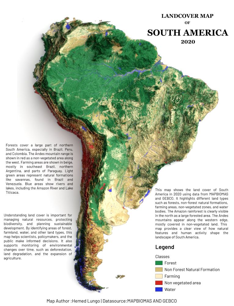
Map showing Landcover of South America
🗺️ Map showing Land Cover of South America (2020)
From the vast Amazon 🌳 to the Andes 🏔️ and farmlands 🌾 — this map reveals how land is used across the continent.
📊 Data:
@mapbiomas
@gebcobathymetry
#GIS #GEBCO #QGIS #Blender #gischat #Cartography #OpenData #SouthAmerica
19.07.2025 15:14 — 👍 7 🔁 1 💬 0 📌 1
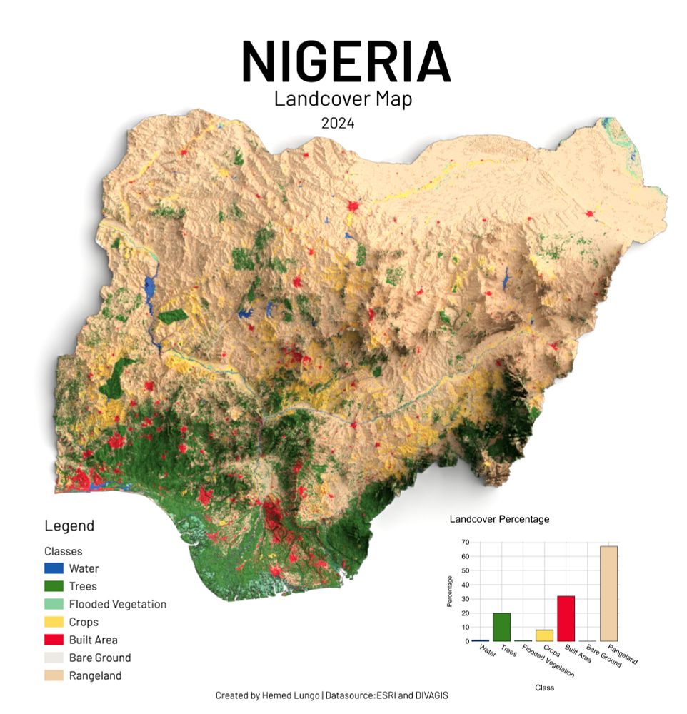
Map showing Landcover of Nigeria
🗺️ Map showing Nigeria Land Cover – 2024 🇳🇬
Made with QGIS & Blender using:
🌱 ESRI Land Cover Data
🏔️ DEM from DivaGIS
Visualizing Nigeria’s diverse landscapes — forests, farmlands, water bodies & urban zones.
#Nigeria #Africa #QGIS #Blender #Cartography #gischat #LandCover #Map
16.07.2025 14:37 — 👍 5 🔁 2 💬 0 📌 0
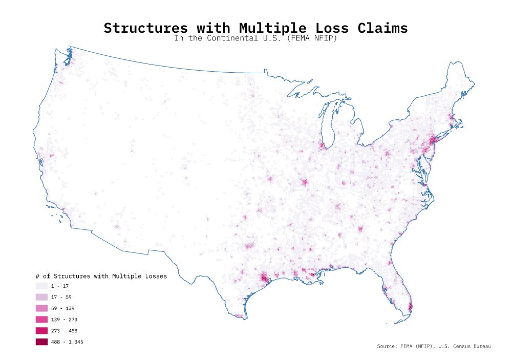
A hex-binned choropleth map showing the number of structures in the continental US with multiple loss claims.
Inspired by @imagineterrain.bsky.social recent maps using the FEMA NFIP dataset, I decided to make a map of my own. After hex binning the data, the spatial pattern more or less follows population centers, at least for the eastern portion of the US.
I am still learning #QGIS!
#GISChat #GIS
11.07.2025 18:53 — 👍 7 🔁 2 💬 0 📌 0
There's some great explanation for how map projections work in this short, but it's too hot today for me to work it out 😅
https://youtube.com/shorts/hrGJIk7zpho?si=xITVIzbJhaNr_qNS
#GISChat
13.07.2025 13:53 — 👍 6 🔁 5 💬 0 📌 0
R and QGIS, name a better combo
#databs
07.07.2025 13:46 — 👍 3 🔁 2 💬 0 📌 0

Alasdair Rae is the Head of Data and Spatial Analysis at Lanpro. Founder of Automatic Knowledge Ltd - geographic data analyst, also Head of Data at Custodian Golf, QGIS trainer and all round geospatial guy.
03.07.2025 15:21 — 👍 3 🔁 2 💬 1 📌 0
YouTube video by To Open Doors
𝐄𝐧𝐠| I.Talk 31🎙 : 25 Years of GIS|QGIS, innovation & Impact | The Journey of @HansvanderKwast
🎙Last Saturday, I had a great chat with Safae Aala on the To Open Doors I.Talk #podcast about my 25-year GIS journey. We covered #QGIS, #opensource, #education & #innovation.
📺 Check it out here: youtu.be/_qhJezrsK-o
#gischat
30.06.2025 07:08 — 👍 3 🔁 2 💬 0 📌 0
Bridgy Fed (https://fed.brid.gy/) bot user for the fediverse. To bridge your Bluesky account to the fediverse, follow this account.
To ask a fediverse user to bridge their account, send their address (eg @user@instance) to this account in a chat message.…
UX researcher, psychologist. Author "Quantitative User Experience Research" (w/Rodden), "R | Python for Marketing Research and Analytics" (w/Feit & Schwarz). Previously 24 yrs @ Google, Amazon, Microsoft. Personal account.
Blog at https://quantuxblog.com
https://emilhvitfeldt.com/
making modeling easier in #rstats with tidymodels at @posit.co
writing about feature engineering (https://feaz-book.com/) and Slidecrafting. He/Him
statistics, science, software
https://www.zeileis.org/
Gaa-zagaskwaajimekaag Anishinaabe | Indigenous Geographies and Climate Justice | Director, GIF Lab | Public Scholar | Adjunct Professor, University of British Columbia | Ohio State, Minnesota-Duluth, St. Cloud State alum | Posts = my views.
GIS and cartography. BW photography. Woodworking. Food, family and adventure. Map posters @ www.etsy.com/shop/MapBliss. BW IG @ www.instagram.com/the.taking.lens/
Bearing Witness . . . . . Maker @ toMake.com
“Not knowing is most intimate.”
Community geographer, cartographer, pedestrian, cyclist. Author of "The New American Small Town: Lessons for sustainable urban futures" (West Virginia University Press, June 2025). https://communitygeography.kent.edu/
💭 pipe dreams #RStats #Python 💜 @Posit.co (formerly RStudio) || ✶ ✶ ✶ ✶ ||
Climate Justice & Climate Accountability Researcher. Postdoctoral Scientist @ UC Merced: https://www.climatologylab.org/
tensor topographer 🗺️
shoggoth conspirator 🦑
joyce junkie 📖
building @riverrun.quest , https://inat-trees.replit.app
Data & Solutions Journalist | Data & Editorial Associate InfoNile| Water Journalists Africa |Groundwater corespondent @UNIGRAC Uganda
Geospatial Librarian, Ithaca NY
6502 assembly. Roman numerals. The music in my head.
🌉 bridged from ⁂ https://mapstodon.space/@kgjenkins, follow @ap.brid.gy to interact
Ecosystem Scientist | Artist | Forests, Wetlands, Peatlands, & Climate Change | Carbon, Moss, Lichens, Permafrost, Fire, Tea | Science-Policy | she/her
GRASS news, tutorials, and other resources on geospatial stuff.
[bridged from https://fosstodon.org/@grassgis on the fediverse by https://fed.brid.gy/ ]
Assistant Professor at Santa Clara University | Epidemiologist and Global Health Researcher interested in spatial demography and infectious diseases | Theatre and Arts enthusiast | nglendening.github.io
PhD (st.) in conservation planning and climate change, M.S. in computer science. Conservationist, FOSS and bike lover 🇨🇴 🇨🇦
Universalizando o acesso a dados. Acesse em basedosdados.org
OSR blogger & speculative cartography enthusiast.
Blog: https://idraluna-archives.bearblog.dev/


