The Storm Prediction Center issues Day 1 Critical Fire Weather Risk at Aug 5, 15:53z for portions of SLC
at Tue, 05 Aug 2025 15:54:19 +0000 via IEMbot
Additional Details Here.
05.08.2025 16:08 — 👍 0 🔁 0 💬 0 📌 0
SLC issues Area Forecast Discussion (AFD) at Aug 5, 4:00 AM MDT
at Tue, 05 Aug 2025 10:01:06 +0000 via IEMbot
Additional Details Here.
05.08.2025 10:08 — 👍 0 🔁 0 💬 0 📌 0
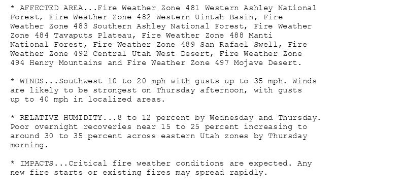
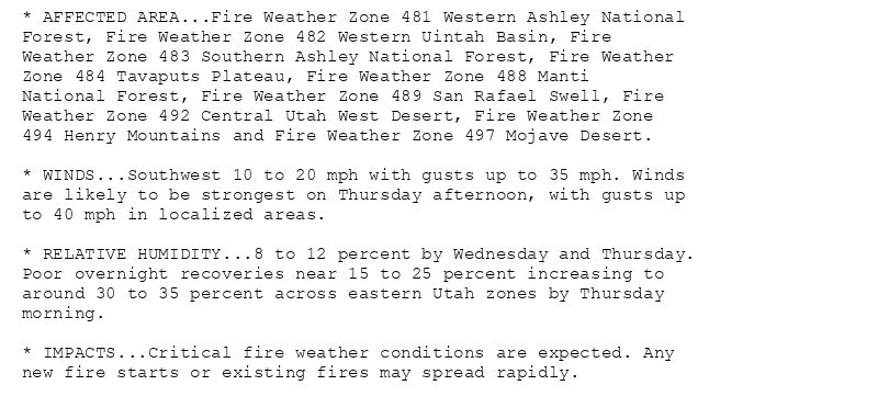
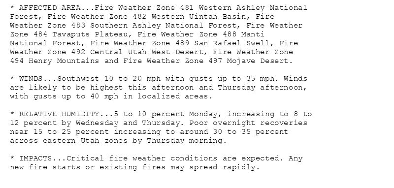
* AFFECTED AREA...Fire Weather Zone 481 Western Ashley National
Forest, Fire Weather Zone 482 Western Uintah Basin, Fire
Weather Zone 483 Southern Ashley National Forest, Fire Weather
Zone 484 Tavaputs Plateau, Fire Weather Zone 488 Manti
National Forest, Fire Weather Zone 489 San Rafael Swell, Fire
Weather Zone 492 Central Utah West Desert, Fire Weather Zone
494 Henry Mountains and Fire Weather Zone 497 Mojave Desert.
* WINDS...Southwest 10 to 20 mph with gusts up to 35 mph. Winds
are likely to be strongest on Thursday afternoon, with gusts
up to 40 mph in localized areas.
* RELATIVE HUMIDITY...8 to 12 percent by Wednesday and Thursday.
Poor overnight recoveries near 15 to 25 percent increasing to
around 30 to 35 percent across eastern Utah zones by Thursday
morning.
* IMPACTS...Critical fire weather conditions are expected. Any
new fire starts or existing fires may spread rapidly.
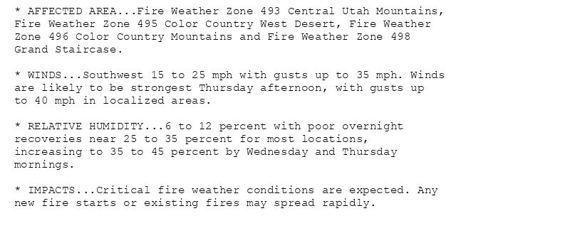
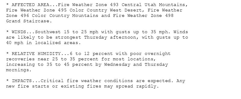
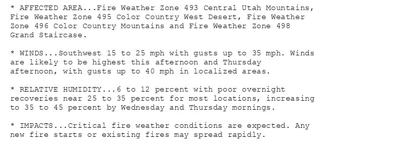
* AFFECTED AREA...Fire Weather Zone 493 Central Utah Mountains,
Fire Weather Zone 495 Color Country West Desert, Fire Weather
Zone 496 Color Country Mountains and Fire Weather Zone 498
Grand Staircase.
* WINDS...Southwest 15 to 25 mph with gusts up to 35 mph. Winds
are likely to be strongest Thursday afternoon, with gusts up
to 40 mph in localized areas.
* RELATIVE HUMIDITY...6 to 12 percent with poor overnight
recoveries near 25 to 35 percent for most locations,
increasing to 35 to 45 percent by Wednesday and Thursday
mornings.
* IMPACTS...Critical fire weather conditions are expected. Any
new fire starts or existing fires may spread rapidly.
🚨 Red Flag Warning issued August 5 at 3:18AM MDT until August 7 at 9:00PM MDT by NWS Salt Lake City UT 🚨
Additional Details Here.
05.08.2025 09:30 — 👍 0 🔁 0 💬 0 📌 0
SLC continues Red Flag Warning (Central Utah Mountains, Central Utah West Desert, Color Country Mountains, Color Country West Desert, Grand Staircase, Henry Mountains, Manti Nation... at Tue, 05 Aug 2025 09:19:04 +0000 via IEMbot
Additional Details Here.
05.08.2025 09:28 — 👍 0 🔁 0 💬 0 📌 0
EVANSTON WY Aug 4
Climate Report:
High: 86
Low: 56
Precip: 0.0"
Snow: Missing
at Tue, 05 Aug 2025 07:43:14 +0000 via IEMbot
Additional Details Here.
05.08.2025 07:48 — 👍 0 🔁 0 💬 0 📌 0
The Storm Prediction Center issues Day 1 Critical Fire Weather Risk at Aug 5, 7:00z for portions of SLC
at Tue, 05 Aug 2025 07:01:26 +0000 via IEMbot
Additional Details Here.
05.08.2025 07:08 — 👍 0 🔁 0 💬 0 📌 0
* AFFECTED AREA...Fire Weather Zone 481 Western Ashley National
Forest, Fire Weather Zone 482 Western Uintah Basin, Fire
Weather Zone 483 Southern Ashley National Forest, Fire Weather
Zone 484 Tavaputs Plateau, Fire Weather Zone 488 Manti
National Forest, Fire Weather Zone 489 San Rafael Swell, Fire
Weather Zone 492 Central Utah West Desert, Fire Weather Zone
494 Henry Mountains and Fire Weather Zone 497 Mojave Desert.
* WINDS...Southwest 10 to 20 mph with gusts up to 35 mph. Winds
are likely to be strongest on Thursday afternoon, with gusts up
to 40 mph in localized areas.
* RELATIVE HUMIDITY...8 to 12 percent by Wednesday and Thursday.
Poor overnight recoveries near 15 to 25 percent increasing to
around 30 to 35 percent across eastern Utah zones by Thursday
morning.
* IMPACTS...Critical fire weather conditions are expected. Any
new fire starts or existing fires may spread rapidly.
* AFFECTED AREA...Fire Weather Zone 493 Central Utah Mountains,
Fire Weather Zone 495 Color Country West Desert, Fire Weather
Zone 496 Color Country Mountains and Fire Weather Zone 498
Grand Staircase.
* WINDS...Southwest 15 to 25 mph with gusts up to 35 mph. Winds
are likely to be strongest Thursday afternoon, with gusts up to
40 mph in localized areas.
* RELATIVE HUMIDITY...6 to 12 percent with poor overnight
recoveries near 25 to 35 percent for most locations,
increasing to 35 to 45 percent by Wednesday and Thursday
mornings.
* IMPACTS...Critical fire weather conditions are expected. Any
new fire starts or existing fires may spread rapidly.
🚨 Red Flag Warning issued August 4 at 9:02PM MDT until August 7 at 9:00PM MDT by NWS Salt Lake City UT 🚨
Additional Details Here.
05.08.2025 03:15 — 👍 0 🔁 1 💬 1 📌 0
SLC updates Red Flag Warning (expires Salt Lake Desert, Wasatch Mountains [UT], continues Central Utah Mountains, Central Utah West Desert, Color Country Mountains, Color Country W... at Tue, 05 Aug 2025 03:03:05 +0000 via IEMbot
Additional Details Here.
05.08.2025 03:08 — 👍 0 🔁 0 💬 0 📌 0
EVANSTON WY Aug 4
Climate Report:
High: 86
Low: 56
Precip: 0.0"
Snow: Missing
at Tue, 05 Aug 2025 00:52:44 +0000 via IEMbot
Additional Details Here.
05.08.2025 01:09 — 👍 0 🔁 0 💬 0 📌 0
CEDAR CITY UT Aug 4
Climate Report:
High: 92
Low: 58
Precip: 0.0"
Snow: Missing
at Tue, 05 Aug 2025 00:52:44 +0000 via IEMbot
Additional Details Here.
05.08.2025 01:08 — 👍 0 🔁 0 💬 0 📌 0
SLC issues Area Forecast Discussion (AFD) at Aug 4, 3:43 PM MDT
at Mon, 04 Aug 2025 21:43:27 +0000 via IEMbot
Additional Details Here.
04.08.2025 21:48 — 👍 0 🔁 0 💬 0 📌 0
The Storm Prediction Center issues Day 4 15% Any Severe Fire Weather Risk at Aug 4, 20:59z for portions of SLC
at Mon, 04 Aug 2025 21:00:44 +0000 via IEMbot
Additional Details Here.
04.08.2025 21:08 — 👍 0 🔁 0 💬 0 📌 0
* AFFECTED AREA...Fire Weather Zone 481 Western Ashley National
Forest, Fire Weather Zone 482 Western Uintah Basin, Fire
Weather Zone 483 Southern Ashley National Forest, Fire Weather
Zone 484 Tavaputs Plateau, Fire Weather Zone 488 Manti
National Forest, Fire Weather Zone 489 San Rafael Swell, Fire
Weather Zone 492 Central Utah West Desert, Fire Weather Zone
494 Henry Mountains and Fire Weather Zone 497 Mojave Desert.
* WINDS...Southwest 10 to 20 mph with gusts up to 35 mph. Winds
are likely to be highest this afternoon and Thursday afternoon,
with gusts up to 40 mph in localized areas.
* RELATIVE HUMIDITY...5 to 10 percent Monday, increasing to 8 to
12 percent by Wednesday and Thursday. Poor overnight recoveries
near 15 to 25 percent increasing to around 30 to 35 percent
across eastern Utah zones by Thursday morning.
* IMPACTS...Critical fire weather conditions are expected. Any
new fire starts or existing fires may spread rapidly.
* AFFECTED AREA...Fire Weather Zone 493 Central Utah Mountains,
Fire Weather Zone 495 Color Country West Desert, Fire Weather
Zone 496 Color Country Mountains and Fire Weather Zone 498
Grand Staircase.
* WINDS...Southwest 15 to 25 mph with gusts up to 35 mph. Winds
are likely to be highest this afternoon and Thursday
afternoon, with gusts up to 40 mph in localized areas.
* RELATIVE HUMIDITY...6 to 12 percent with poor overnight
recoveries near 25 to 35 percent for most locations, increasing
to 35 to 45 percent by Wednesday and Thursday mornings.
* IMPACTS...Critical fire weather conditions are expected. Any
new fire starts or existing fires may spread rapidly.
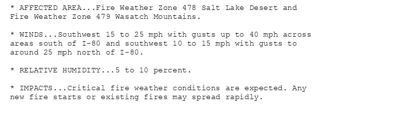
* AFFECTED AREA...Fire Weather Zone 478 Salt Lake Desert and
Fire Weather Zone 479 Wasatch Mountains.
* WINDS...Southwest 15 to 25 mph with gusts up to 40 mph across
areas south of I-80 and southwest 10 to 15 mph with gusts to
around 25 mph north of I-80.
* RELATIVE HUMIDITY...5 to 10 percent.
* IMPACTS...Critical fire weather conditions are expected. Any
new fire starts or existing fires may spread rapidly.
🚨 Red Flag Warning issued August 4 at 2:19PM MDT until August 7 at 9:00PM MDT by NWS Salt Lake City UT 🚨
Additional Details Here.
04.08.2025 20:30 — 👍 0 🔁 0 💬 0 📌 0
SLC updates Red Flag Warning (extends time of Central Utah Mountains, Central Utah West Desert, Color Country Mountains, Color Country West Desert, Grand Staircase, Henry Mountains... at Mon, 04 Aug 2025 20:20:18 +0000 via IEMbot
Additional Details Here.
04.08.2025 20:28 — 👍 0 🔁 0 💬 0 📌 0
The Storm Prediction Center issues Day 1 Critical Fire Weather Risk at Aug 4, 16:38z for portions of SLC
at Mon, 04 Aug 2025 16:40:28 +0000 via IEMbot
Additional Details Here.
04.08.2025 16:48 — 👍 0 🔁 1 💬 0 📌 0
SLC issues Area Forecast Discussion (AFD) at Aug 4, 3:48 AM MDT
at Mon, 04 Aug 2025 09:48:30 +0000 via IEMbot
Additional Details Here.
04.08.2025 10:08 — 👍 0 🔁 0 💬 0 📌 0
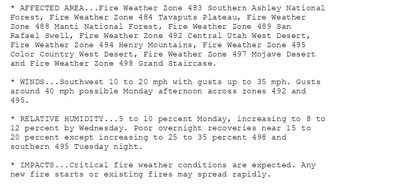
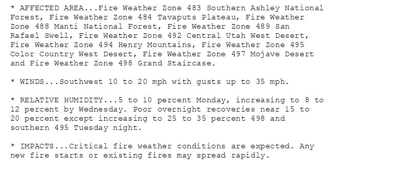
* AFFECTED AREA...Fire Weather Zone 483 Southern Ashley National
Forest, Fire Weather Zone 484 Tavaputs Plateau, Fire Weather
Zone 488 Manti National Forest, Fire Weather Zone 489 San
Rafael Swell, Fire Weather Zone 492 Central Utah West Desert,
Fire Weather Zone 494 Henry Mountains, Fire Weather Zone 495
Color Country West Desert, Fire Weather Zone 497 Mojave Desert
and Fire Weather Zone 498 Grand Staircase.
* WINDS...Southwest 10 to 20 mph with gusts up to 35 mph. Gusts
around 40 mph possible Monday afternoon across zones 492 and
495.
* RELATIVE HUMIDITY...5 to 10 percent Monday, increasing to 8 to
12 percent by Wednesday. Poor overnight recoveries near 15 to
20 percent except increasing to 25 to 35 percent 498 and
southern 495 Tuesday night.
* IMPACTS...Critical fire weather conditions are expected. Any
new fire starts or existing fires may spread rapidly.
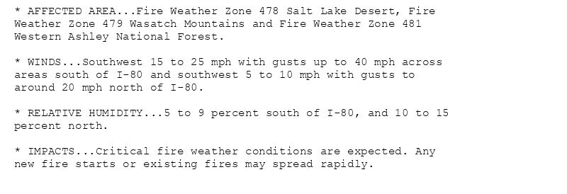
* AFFECTED AREA...Fire Weather Zone 478 Salt Lake Desert, Fire
Weather Zone 479 Wasatch Mountains and Fire Weather Zone 481
Western Ashley National Forest.
* WINDS...Southwest 15 to 25 mph with gusts up to 40 mph across
areas south of I-80 and southwest 5 to 10 mph with gusts to
around 20 mph north of I-80.
* RELATIVE HUMIDITY...5 to 9 percent south of I-80, and 10 to 15
percent north.
* IMPACTS...Critical fire weather conditions are expected. Any
new fire starts or existing fires may spread rapidly.
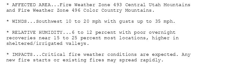
* AFFECTED AREA...Fire Weather Zone 493 Central Utah Mountains
and Fire Weather Zone 496 Color Country Mountains.
* WINDS...Southwest 10 to 20 mph with gusts up to 35 mph.
* RELATIVE HUMIDITY...6 to 12 percent with poor overnight
recoveries near 15 to 25 percent most locations, higher in
sheltered/irrigated valleys.
* IMPACTS...Critical fire weather conditions are expected. Any
new fire starts or existing fires may spread rapidly.
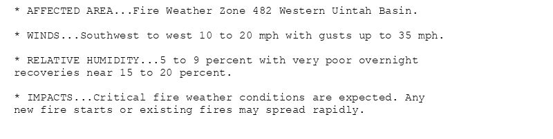
* AFFECTED AREA...Fire Weather Zone 482 Western Uintah Basin.
* WINDS...Southwest to west 10 to 20 mph with gusts up to 35 mph.
* RELATIVE HUMIDITY...5 to 9 percent with very poor overnight
recoveries near 15 to 20 percent.
* IMPACTS...Critical fire weather conditions are expected. Any
new fire starts or existing fires may spread rapidly.
🚨 Red Flag Warning issued August 4 at 3:15AM MDT until August 6 at 9:00PM MDT by NWS Salt Lake City UT 🚨
Additional Details Here.(1/2)
04.08.2025 09:30 — 👍 0 🔁 0 💬 0 📌 0
CEDAR CITY UT Aug 3
Climate Report:
High: 92
Low: 51
Precip: 0.0"
Snow: Missing
at Mon, 04 Aug 2025 07:26:35 +0000 via IEMbot
Additional Details Here.
04.08.2025 07:28 — 👍 0 🔁 0 💬 0 📌 0
The Storm Prediction Center issues Day 1 Critical Fire Weather Risk at Aug 4, 6:56z for portions of SLC
at Mon, 04 Aug 2025 06:58:27 +0000 via IEMbot
Additional Details Here.
04.08.2025 07:08 — 👍 0 🔁 0 💬 0 📌 0
EVANSTON WY Aug 3
Climate Report:
High: 84
Low: 50
Precip: 0.0"
Snow: Missing
at Mon, 04 Aug 2025 00:46:55 +0000 via IEMbot
Additional Details Here.
04.08.2025 00:49 — 👍 0 🔁 0 💬 0 📌 0
* AFFECTED AREA...Fire Weather Zone 482 Western Uintah Basin.
* WINDS...Southwest to west 10 to 20 mph with gusts up to 35 mph.
* RELATIVE HUMIDITY...5 to 9 percent with very poor overnight
recoveries near 15 to 20 percent.
* IMPACTS...Critical fire weather conditions are expected. Any
new fire starts or existing fires may spread rapidly.
🚨 Red Flag Warning issued August 3 at 5:48PM MDT until August 4 at 9:00PM MDT by NWS Salt Lake City UT 🚨
Additional Details Here.(2/2)
04.08.2025 00:00 — 👍 0 🔁 0 💬 0 📌 0
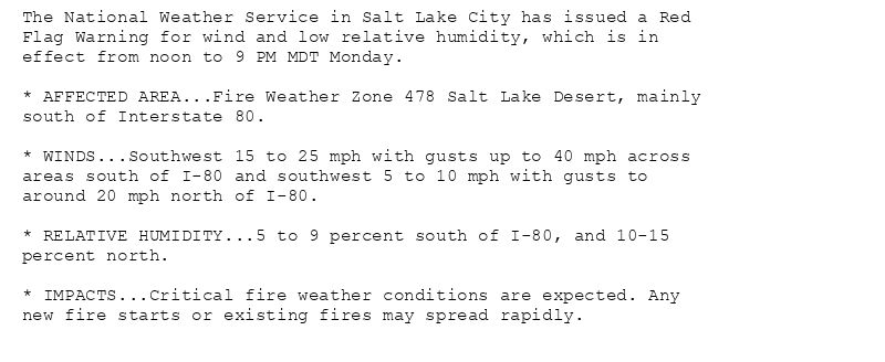
The National Weather Service in Salt Lake City has issued a Red
Flag Warning for wind and low relative humidity, which is in
effect from noon to 9 PM MDT Monday.
* AFFECTED AREA...Fire Weather Zone 478 Salt Lake Desert, mainly
south of Interstate 80.
* WINDS...Southwest 15 to 25 mph with gusts up to 40 mph across
areas south of I-80 and southwest 5 to 10 mph with gusts to
around 20 mph north of I-80.
* RELATIVE HUMIDITY...5 to 9 percent south of I-80, and 10-15
percent north.
* IMPACTS...Critical fire weather conditions are expected. Any
new fire starts or existing fires may spread rapidly.
* AFFECTED AREA...Fire Weather Zone 483 Southern Ashley National
Forest, Fire Weather Zone 484 Tavaputs Plateau, Fire Weather
Zone 488 Manti National Forest, Fire Weather Zone 489 San
Rafael Swell, Fire Weather Zone 492 Central Utah West Desert,
Fire Weather Zone 494 Henry Mountains, Fire Weather Zone 495
Color Country West Desert, Fire Weather Zone 497 Mojave Desert
and Fire Weather Zone 498 Grand Staircase.
* WINDS...Southwest 10 to 20 mph with gusts up to 35 mph. Gusts
around 40 mph possible Monday afternoon across zones 492 and
495.
* RELATIVE HUMIDITY...5 to 10 percent Monday, increasing to 8 to
12 percent by Wednesday. Poor overnight recoveries near 15 to
20 percent except increasing to 25 to 35 percent 498 and
southern 495 Tuesday night.
* IMPACTS...Critical fire weather conditions are expected. Any
new fire starts or existing fires may spread rapidly.
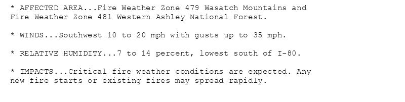
* AFFECTED AREA...Fire Weather Zone 479 Wasatch Mountains and
Fire Weather Zone 481 Western Ashley National Forest.
* WINDS...Southwest 10 to 20 mph with gusts up to 35 mph.
* RELATIVE HUMIDITY...7 to 14 percent, lowest south of I-80.
* IMPACTS...Critical fire weather conditions are expected. Any
new fire starts or existing fires may spread rapidly.
* AFFECTED AREA...Fire Weather Zone 493 Central Utah Mountains
and Fire Weather Zone 496 Color Country Mountains.
* WINDS...Southwest 10 to 20 mph with gusts up to 35 mph.
* RELATIVE HUMIDITY...6 to 12 percent with poor overnight
recoveries near 15 to 25 percent most locations, higher in
sheltered/irrigated valleys.
* IMPACTS...Critical fire weather conditions are expected. Any
new fire starts or existing fires may spread rapidly.
🚨 Red Flag Warning issued August 3 at 5:48PM MDT until August 4 at 9:00PM MDT by NWS Salt Lake City UT 🚨
Additional Details Here.
(1/2)
04.08.2025 00:00 — 👍 0 🔁 0 💬 1 📌 0
SLC updates Red Flag Warning (expands area to include Salt Lake Desert [UT], continues Central Utah Mountains, Central Utah West Desert, Color Country Mountains, Color Country West... at Sun, 03 Aug 2025 23:48:40 +0000 via IEMbot
Additional Details Here.
03.08.2025 23:48 — 👍 0 🔁 0 💬 0 📌 0
SLC issues Area Forecast Discussion (AFD) at Aug 3, 2:32 PM MDT
at Sun, 03 Aug 2025 20:34:16 +0000 via IEMbot
Additional Details Here.
03.08.2025 20:48 — 👍 0 🔁 0 💬 0 📌 0
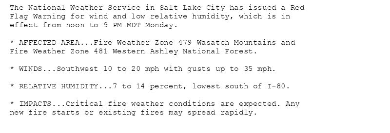
The National Weather Service in Salt Lake City has issued a Red
Flag Warning for wind and low relative humidity, which is in
effect from noon to 9 PM MDT Monday.
* AFFECTED AREA...Fire Weather Zone 479 Wasatch Mountains and
Fire Weather Zone 481 Western Ashley National Forest.
* WINDS...Southwest 10 to 20 mph with gusts up to 35 mph.
* RELATIVE HUMIDITY...7 to 14 percent, lowest south of I-80.
* IMPACTS...Critical fire weather conditions are expected. Any
new fire starts or existing fires may spread rapidly.
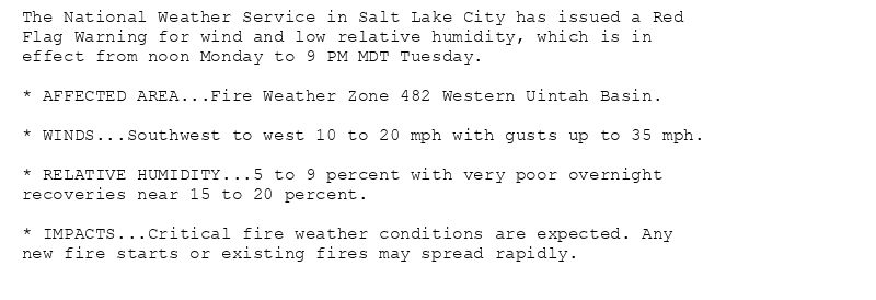
The National Weather Service in Salt Lake City has issued a Red
Flag Warning for wind and low relative humidity, which is in
effect from noon Monday to 9 PM MDT Tuesday.
* AFFECTED AREA...Fire Weather Zone 482 Western Uintah Basin.
* WINDS...Southwest to west 10 to 20 mph with gusts up to 35 mph.
* RELATIVE HUMIDITY...5 to 9 percent with very poor overnight
recoveries near 15 to 20 percent.
* IMPACTS...Critical fire weather conditions are expected. Any
new fire starts or existing fires may spread rapidly.
* AFFECTED AREA...Fire Weather Zone 483 Southern Ashley National
Forest, Fire Weather Zone 484 Tavaputs Plateau, Fire Weather
Zone 488 Manti National Forest, Fire Weather Zone 489 San
Rafael Swell, Fire Weather Zone 492 Central Utah West Desert,
Fire Weather Zone 494 Henry Mountains, Fire Weather Zone 495
Color Country West Desert, Fire Weather Zone 497 Mojave Desert
and Fire Weather Zone 498 Grand Staircase.
* WINDS...Southwest 10 to 20 mph with gusts up to 35 mph.
* RELATIVE HUMIDITY...5 to 10 percent Monday, increasing to 8 to
12 percent by Wednesday. Poor overnight recoveries near 15 to
20 percent except increasing to 25 to 35 percent 498 and
southern 495 Tuesday night.
* IMPACTS...Critical fire weather conditions are expected. Any
new fire starts or existing fires may spread rapidly.
* AFFECTED AREA...Fire Weather Zone 493 Central Utah Mountains
and Fire Weather Zone 496 Color Country Mountains.
* WINDS...Southwest 10 to 20 mph with gusts up to 35 mph.
* RELATIVE HUMIDITY...6 to 12 percent with poor overnight
recoveries near 15 to 25 percent most locations, higher in
sheltered/irrigated valleys.
* IMPACTS...Critical fire weather conditions are expected. Any
new fire starts or existing fires may spread rapidly.
🚨 Red Flag Warning issued August 3 at 11:06AM MDT until August 4 at 9:00PM MDT by NWS Salt Lake City UT 🚨
Additional Details Here.(1/2)
03.08.2025 17:15 — 👍 0 🔁 0 💬 0 📌 0
SLC updates Red Flag Warning (extends time and expands area to include Wasatch Mountains, Western Ashley National Forest [UT], expands area to include Western Uintah Basin [UT], ex... at Sun, 03 Aug 2025 17:07:08 +0000 via IEMbot
Additional Details Here.
03.08.2025 17:08 — 👍 0 🔁 0 💬 0 📌 0
The Storm Prediction Center issues Day 1 Elevated Fire Weather Risk at Aug 3, 16:41z for portions of SLC
at Sun, 03 Aug 2025 16:42:36 +0000 via IEMbot
Additional Details Here.
03.08.2025 16:48 — 👍 0 🔁 0 💬 0 📌 0
SLC issues Area Forecast Discussion (AFD) at Aug 3, 3:51 AM MDT
at Sun, 03 Aug 2025 09:51:43 +0000 via IEMbot
Additional Details Here.
03.08.2025 10:08 — 👍 0 🔁 0 💬 0 📌 0
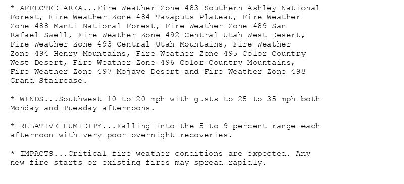
* AFFECTED AREA...Fire Weather Zone 483 Southern Ashley National
Forest, Fire Weather Zone 484 Tavaputs Plateau, Fire Weather
Zone 488 Manti National Forest, Fire Weather Zone 489 San
Rafael Swell, Fire Weather Zone 492 Central Utah West Desert,
Fire Weather Zone 493 Central Utah Mountains, Fire Weather
Zone 494 Henry Mountains, Fire Weather Zone 495 Color Country
West Desert, Fire Weather Zone 496 Color Country Mountains,
Fire Weather Zone 497 Mojave Desert and Fire Weather Zone 498
Grand Staircase.
* WINDS...Southwest 10 to 20 mph with gusts to 25 to 35 mph both
Monday and Tuesday afternoons.
* RELATIVE HUMIDITY...Falling into the 5 to 9 percent range each
afternoon with very poor overnight recoveries.
* IMPACTS...Critical fire weather conditions are expected. Any
new fire starts or existing fires may spread rapidly.
🚨 Red Flag Warning issued August 3 at 2:37AM MDT until August 5 at 9:00PM MDT by NWS Salt Lake City UT 🚨
Additional Details Here.
03.08.2025 08:45 — 👍 0 🔁 0 💬 0 📌 0
CEDAR CITY UT Aug 2
Climate Report:
High: 92
Low: 58
Precip: 0.0"
Snow: Missing
at Sun, 03 Aug 2025 07:34:02 +0000 via IEMbot
Additional Details Here.
03.08.2025 07:48 — 👍 0 🔁 0 💬 0 📌 0