

arXiv: arxiv.org/abs/2504.03603
22.10.2025 12:46 — 👍 0 🔁 0 💬 0 📌 0
arXiv: arxiv.org/abs/2504.03603
22.10.2025 12:46 — 👍 0 🔁 0 💬 0 📌 0
View-only: rdcu.be/eL0JC
22.10.2025 12:46 — 👍 0 🔁 0 💬 1 📌 0This was a lot of fun to work on -- big thanks to everyone involved and particularly Xianyuan Liu and Haiping Lu for leading this effort!
22.10.2025 12:46 — 👍 0 🔁 0 💬 1 📌 0Many great scientific challenges are both multimodal and multidisciplinary. In our perspective we discuss the additional challenges this brings for developing deployable AI, and provide recommendations to address these challenges early on.
22.10.2025 12:46 — 👍 0 🔁 0 💬 1 📌 0
Our perspective on deployment-centric, multimodal AI beyond vision and language is now out in Nature Machine Intelligence!
www.nature.com/articles/s42...

Code: github.com/LTER-LIFE/ll... [5/5]
07.10.2025 11:47 — 👍 0 🔁 0 💬 0 📌 0
Paper: doi.org/10.1007/978-... [4/5]
07.10.2025 11:47 — 👍 0 🔁 0 💬 1 📌 0We presented our tool at the recent EcoDL workshop at TPDL2025, and our paper and code are now both available open-access at the links below! Big thanks to the rest of the team, and please let us know any thoughts and suggestions as we continue to develop this tool! [3/5]
07.10.2025 11:47 — 👍 0 🔁 0 💬 1 📌 0In a nutshell, we successfully used LLMs to flexibly extract and convert metadata of ecological datasets (e.g., by scraping datasets webpages), with equal accuracy for both structured and unstructured metadata. [2/5]
07.10.2025 11:47 — 👍 0 🔁 0 💬 1 📌 0Can LLMs do our 'digital dishes'? Or in other words, what are tedious, small tasks that researchers often face and could be automated by LLMs? We've worked on one such task: extracting dataset metadata and converting these to a single format to build a dataset knowledge base. [1/5]
07.10.2025 11:47 — 👍 2 🔁 0 💬 1 📌 0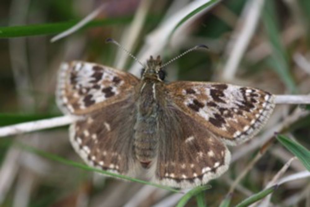
Great read from Michael Pocock: Linking remote sensing, citizen science data and AI could transform environmental monitoring | UK Centre for Ecology & Hydrology www.ceh.ac.uk/news-and-med...
15.07.2025 09:04 — 👍 2 🔁 0 💬 0 📌 0There is still lots of scope for further improvements; if that's of interest please don't hesitate to get in touch!
17.06.2025 09:57 — 👍 0 🔁 0 💬 0 📌 0We combined sentinel-2 images and UKBMS butterfly occurrence records to predict butterfly species presence from satellite data. We developed a soft contrastive loss that acts as a regulariser and improves prediction accuracy.
17.06.2025 09:57 — 👍 0 🔁 0 💬 1 📌 0
Published last week at the CVPR FGVC Workshop; our paper on "Predicting butterfly species presence from satellite imagery using soft contrastive regularisation".
PDF (with links to data/code) available here:
openaccess.thecvf.com/content/CVPR...
With @david-alexander.bsky.social
20.05.2025 08:42 — 👍 0 🔁 0 💬 0 📌 0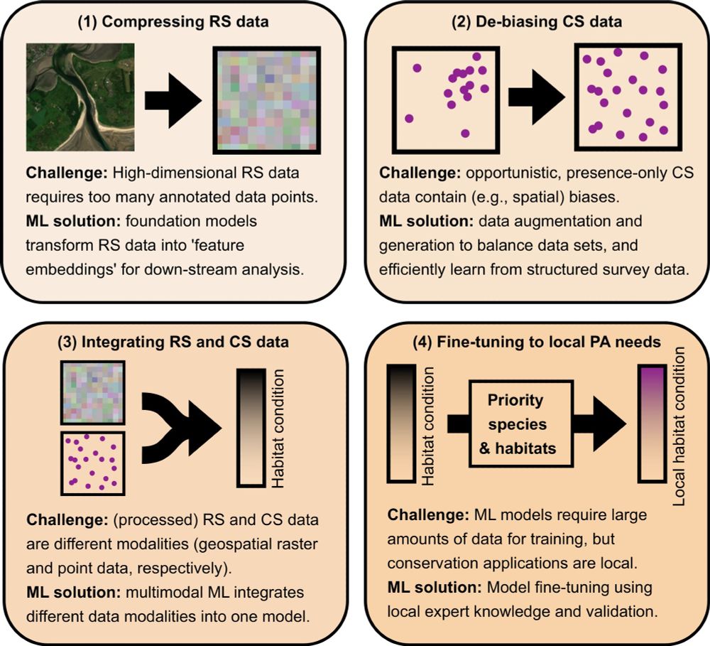
In our latest perspective article, we outline how ML can overcome 4 current obstacles for large-scale, high-resolution monitoring of protected areas.
doi.org/10.1002/2688...
Hope this stimulates the conversation and provides a pathway of how ML research can be applied for monitoring PAs at scale.
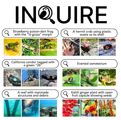
🎯 How can we empower scientific discovery in millions of nature photos?
Introducing INQUIRE: A benchmark testing if AI vision-language models can help scientists find biodiversity patterns- from disease symptoms to rare behaviors- hidden in vast image collections.
Thread👇🧵
Hi, I'm using satellite data to predict species biodiversity! Could I be added please :) Thanks!
23.11.2024 10:29 — 👍 3 🔁 0 💬 0 📌 0
Using computer vision and #MapReader software, we analysed the loss of field boundaries across the #PeakDistrict Since the 1950s, the White Peak has seen a 12% reduction-551 km lost from an original 4,814 km. A stark reminder of landscape change 📊🌿 storymaps.arcgis.com/stories/5c89... #maps #GIS
21.11.2024 19:52 — 👍 23 🔁 9 💬 1 📌 1