Day 3-8 Fire Weather Outlook
NWS Storm Prediction Center Norman OK
0337 PM CDT Wed Aug 06 2025
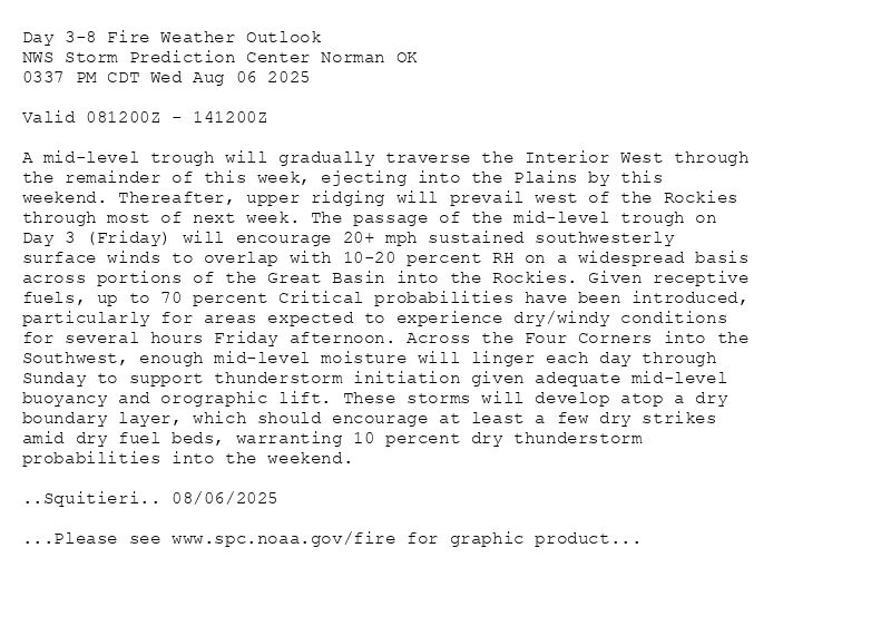
Valid 081200Z - 141200Z
A mid-level trough will gradually traverse the Interior West through
the remainder of this week, ejecting into the Plains by this
weekend. Thereafter, upper ridging will prevail west of the Rockies
through most of next week. The passage of the mid-level trough on
Day 3 (Friday) will encourage 20+ mph sustained southwesterly
surface winds to overlap with 10-20 percent RH on a widespread basis
across portions of the Great Basin into the Rockies. Given receptive
fuels, up to 70 percent Critical probabilities have been introduced,
particularly for areas expected to experience dry/windy conditions
for several hours Friday afternoon. Across the Four Corners into the
Southwest, enough mid-level moisture will linger each day through
Sunday to support thunderstorm initiation given adequate mid-level
buoyancy and orographic lift. These storms will develop atop a dry
boundary layer, which should encourage at least a few dry strikes
amid dry fuel beds, warranting 10 percent dry thunderstorm
probabilities into the weekend.
..Squitieri.. 08/06/2025
...Please see www.spc.noaa.gov/fire for graphic product...
Day 3-8 Fire Weather Outlook Image
SPC Day 3-8 Fire Weather Outlook posted at Wed, 06 Aug 2025 20:42:17 +0000
🔥Please see www.spc.noaa.gov/fire for graphic product🔥
Additional Details Here.
06.08.2025 21:00 — 👍 0 🔁 0 💬 0 📌 0
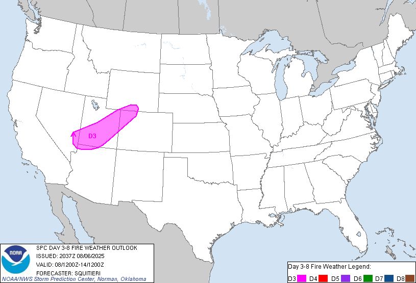
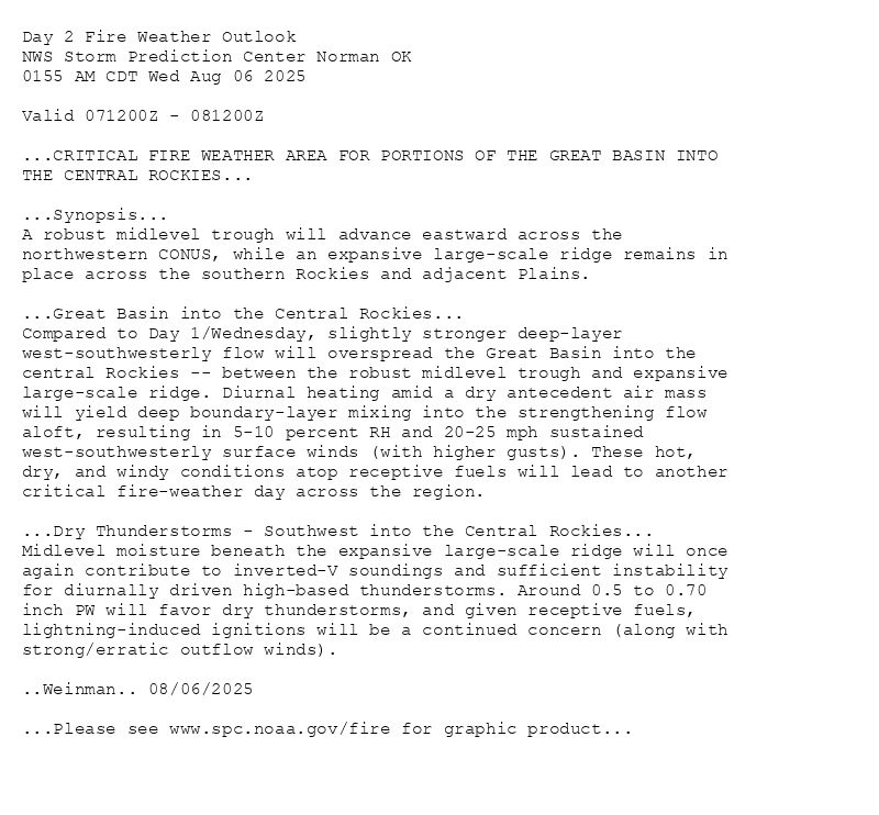
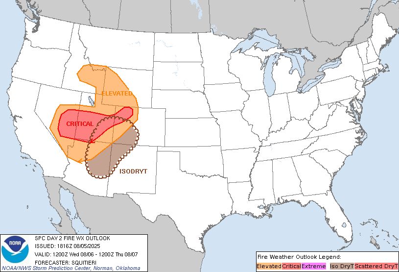
Day 2 Fire Weather Outlook
NWS Storm Prediction Center Norman OK
0155 PM CDT Wed Aug 06 2025
Valid 071200Z - 081200Z
...CRITICAL FIRE WEATHER AREA FOR PORTIONS OF THE GREAT BASIN INTO
THE CENTRAL ROCKIES...
Much of the forecast remains on track, with only minor changes made
to ongoing highlights to reflect the latest guidance consensus.
..Squitieri.. 08/06/2025
.PREV DISCUSSION... /ISSUED 0155 AM CDT Wed Aug 06 2025/
...Synopsis...
A robust midlevel trough will advance eastward across the
northwestern CONUS, while an expansive large-scale ridge remains in
place across the southern Rockies and adjacent Plains.
...Great Basin into the Central Rockies...
Compared to Day 1/Wednesday, slightly stronger deep-layer
west-southwesterly flow will overspread the Great Basin into the
central Rockies -- between the robust midlevel trough and expansive
large-scale ridge. Diurnal heating amid a dry antecedent air mass
will yield deep boundary-layer mixing into the strengthening flow
aloft, resulting in 5-10 percent RH and 20-25 mph sustained
west-southwesterly surface winds (with higher gusts). These hot,
dry, and windy conditions atop receptive fuels will lead to another
critical fire-weather day across the region.
...Dry Thunderstorms - Southwest into the Central Rockies...
Midlevel moisture beneath the expansive large-scale ridge will once
again contribute to inverted-V soundings and sufficient instability
for diurnally driven high-based thunderstorms. Around 0.5 to 0.70
inch PW will favor dry thunderstorms, and given receptive fuels,
lightning-induced ignitions will be a continued concern (along with
strong/erratic outflow winds).
...Please see www.spc.noaa.gov/fire for graphic product...
Day 2 Fire Weather Outlook Image
SPC Day 2 Fire Weather Outlook posted at Wed, 06 Aug 2025 18:56:26 +0000
🔥CRITICAL FIRE WEATHER AREA FOR PORTIONS OF THE GREAT BASIN INTO
THE CENTRAL ROCKIES🔥
Additional Details Here.
06.08.2025 19:00 — 👍 0 🔁 0 💬 0 📌 0
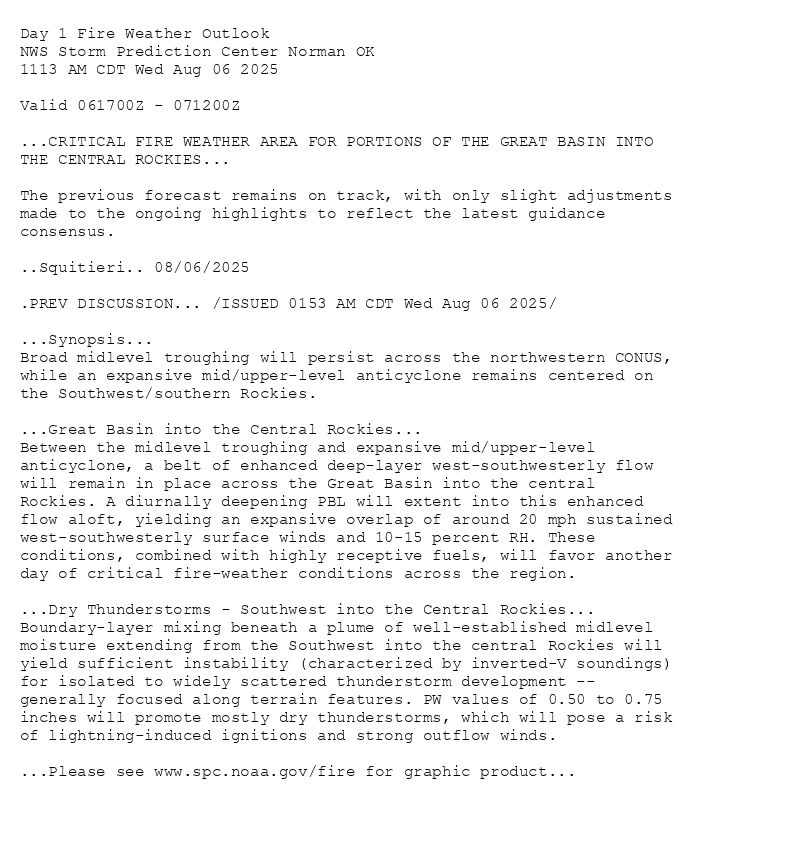
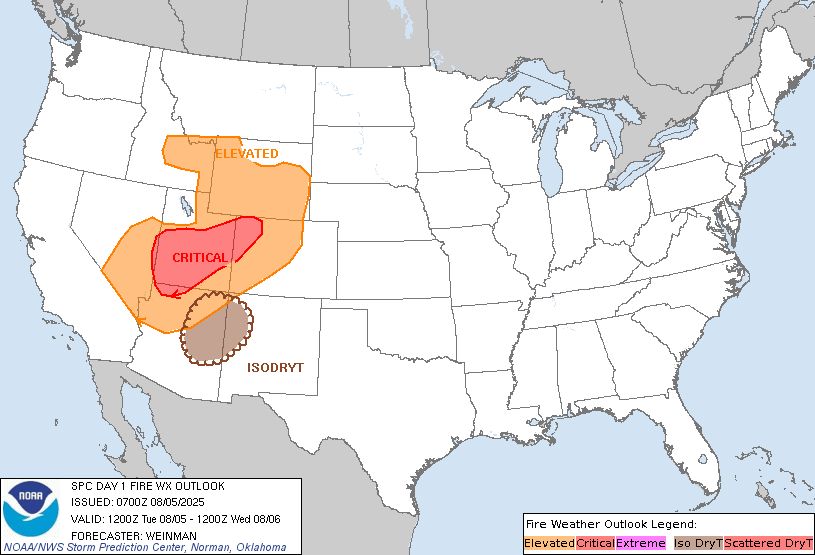
Day 1 Fire Weather Outlook
NWS Storm Prediction Center Norman OK
1113 AM CDT Wed Aug 06 2025
Valid 061700Z - 071200Z
...CRITICAL FIRE WEATHER AREA FOR PORTIONS OF THE GREAT BASIN INTO
THE CENTRAL ROCKIES...
The previous forecast remains on track, with only slight adjustments
made to the ongoing highlights to reflect the latest guidance
consensus.
..Squitieri.. 08/06/2025
.PREV DISCUSSION... /ISSUED 0153 AM CDT Wed Aug 06 2025/
...Synopsis...
Broad midlevel troughing will persist across the northwestern CONUS,
while an expansive mid/upper-level anticyclone remains centered on
the Southwest/southern Rockies.
...Great Basin into the Central Rockies...
Between the midlevel troughing and expansive mid/upper-level
anticyclone, a belt of enhanced deep-layer west-southwesterly flow
will remain in place across the Great Basin into the central
Rockies. A diurnally deepening PBL will extent into this enhanced
flow aloft, yielding an expansive overlap of around 20 mph sustained
west-southwesterly surface winds and 10-15 percent RH. These
conditions, combined with highly receptive fuels, will favor another
day of critical fire-weather conditions across the region.
...Dry Thunderstorms - Southwest into the Central Rockies...
Boundary-layer mixing beneath a plume of well-established midlevel
moisture extending from the Southwest into the central Rockies will
yield sufficient instability (characterized by inverted-V soundings)
for isolated to widely scattered thunderstorm development --
generally focused along terrain features. PW values of 0.50 to 0.75
inches will promote mostly dry thunderstorms, which will pose a risk
of lightning-induced ignitions and strong outflow winds.
...Please see www.spc.noaa.gov/fire for graphic product...
Day 1 Fire Weather Outlook Image
SPC Day 1 Fire Weather Outlook posted at Wed, 06 Aug 2025 16:14:26 +0000
🔥CRITICAL FIRE WEATHER AREA FOR PORTIONS OF THE GREAT BASIN INTO
THE CENTRAL ROCKIES🔥
Additional Details Here.
06.08.2025 16:40 — 👍 0 🔁 0 💬 0 📌 0
Day 2 Fire Weather Outlook
NWS Storm Prediction Center Norman OK
0155 AM CDT Wed Aug 06 2025
Valid 071200Z - 081200Z
...CRITICAL FIRE WEATHER AREA FOR PORTIONS OF THE GREAT BASIN INTO
THE CENTRAL ROCKIES...
...Synopsis...
A robust midlevel trough will advance eastward across the
northwestern CONUS, while an expansive large-scale ridge remains in
place across the southern Rockies and adjacent Plains.
...Great Basin into the Central Rockies...
Compared to Day 1/Wednesday, slightly stronger deep-layer
west-southwesterly flow will overspread the Great Basin into the
central Rockies -- between the robust midlevel trough and expansive
large-scale ridge. Diurnal heating amid a dry antecedent air mass
will yield deep boundary-layer mixing into the strengthening flow
aloft, resulting in 5-10 percent RH and 20-25 mph sustained
west-southwesterly surface winds (with higher gusts). These hot,
dry, and windy conditions atop receptive fuels will lead to another
critical fire-weather day across the region.
...Dry Thunderstorms - Southwest into the Central Rockies...
Midlevel moisture beneath the expansive large-scale ridge will once
again contribute to inverted-V soundings and sufficient instability
for diurnally driven high-based thunderstorms. Around 0.5 to 0.70
inch PW will favor dry thunderstorms, and given receptive fuels,
lightning-induced ignitions will be a continued concern (along with
strong/erratic outflow winds).
..Weinman.. 08/06/2025
...Please see www.spc.noaa.gov/fire for graphic product...
Day 2 Fire Weather Outlook Image
SPC Day 2 Fire Weather Outlook posted at Wed, 06 Aug 2025 06:57:26 +0000
🔥CRITICAL FIRE WEATHER AREA FOR PORTIONS OF THE GREAT BASIN INTO
THE CENTRAL ROCKIES🔥
Additional Details Here.
06.08.2025 07:00 — 👍 0 🔁 0 💬 0 📌 0
Day 1 Fire Weather Outlook
NWS Storm Prediction Center Norman OK
0153 AM CDT Wed Aug 06 2025
Valid 061200Z - 071200Z
...CRITICAL FIRE WEATHER AREA FOR PORTIONS OF THE GREAT BASIN INTO
THE CENTRAL ROCKIES...
...Synopsis...
Broad midlevel troughing will persist across the northwestern CONUS,
while an expansive mid/upper-level anticyclone remains centered on
the Southwest/southern Rockies.
...Great Basin into the Central Rockies...
Between the midlevel troughing and expansive mid/upper-level
anticyclone, a belt of enhanced deep-layer west-southwesterly flow
will remain in place across the Great Basin into the central
Rockies. A diurnally deepening PBL will extent into this enhanced
flow aloft, yielding an expansive overlap of around 20 mph sustained
west-southwesterly surface winds and 10-15 percent RH. These
conditions, combined with highly receptive fuels, will favor another
day of critical fire-weather conditions across the region.
...Dry Thunderstorms - Southwest into the Central Rockies...
Boundary-layer mixing beneath a plume of well-established midlevel
moisture extending from the Southwest into the central Rockies will
yield sufficient instability (characterized by inverted-V soundings)
for isolated to widely scattered thunderstorm development --
generally focused along terrain features. PW values of 0.50 to 0.75
inches will promote mostly dry thunderstorms, which will pose a risk
of lightning-induced ignitions and strong outflow winds.
..Weinman.. 08/06/2025
...Please see www.spc.noaa.gov/fire for graphic product...

Day 1 Fire Weather Outlook Image
SPC Day 1 Fire Weather Outlook posted at Wed, 06 Aug 2025 06:55:27 +0000
🔥CRITICAL FIRE WEATHER AREA FOR PORTIONS OF THE GREAT BASIN INTO
THE CENTRAL ROCKIES🔥
Additional Details Here.
06.08.2025 07:00 — 👍 0 🔁 0 💬 0 📌 0
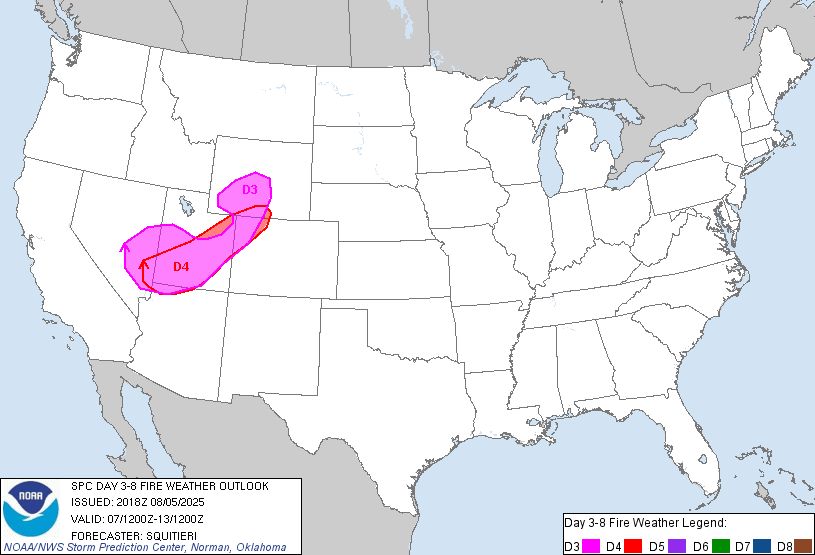
Day 3-8 Fire Weather Outlook
NWS Storm Prediction Center Norman OK
0318 PM CDT Tue Aug 05 2025
Valid 071200Z - 131200Z
A mid-level trough will gradually progress across the northwestern
U.S. through the weekend, before ejecting into the Plains and zonal
flow becoming established west of the Rockies by early next week.
Multiple mid-level impulses are poised to pivot around the main
upper trough, promoting critically dry and windy conditions across
parts of the Interior West toward the end of this week, with
isolated dry thunderstorms possible each day through the weekend.
...Days 3-4 (Thursday-Friday) - Great Basin into the Rockies...
As multiple mid-level impulses continue to graze the Interior West,
15-25 mph sustained southwesterly surface wind should coincide with
5-15 percent RH Thursday and Friday. Fuels are receptive across the
entire region, and 40/70 percent highlights have been added where
confidence is highest in the aforementioned dry/windy conditions
overlapping for several hours each afternoon. Surface winds should
be strongest across the Great Basin on Thursday, where high-end
Critical conditions are possible as a 500 mb wind maximum glances by
to the north.
...Days 3-6 (Thursday-Sunday) - Portions of the Southwest...
Toward the end of the week into the weekend, isolated thunderstorm
development is expected each afternoon to the immediate south and
east of the Four Corners region. Modest southwesterly 500 mb flow
pivoting around an upper ridge will encourage forward motion of any
thunderstorms that develop. Given the presence of a hot and dry
boundary layer across the Southwest, these storms should be
high-based, with at least a mix of wet/dry storms likely. Isolated
dry thunderstorm highlights have been added on Thursday-Sunday for
areas that have experienced minimal rainfall, and where fuels appear
to be highly susceptible to lightning-induced ignitions.
..Squitieri.. 08/05/2025
...Please see www.spc.noaa.gov/fire for graphic product...
Day 3-8 Fire Weather Outlook Image
SPC Day 3-8 Fire Weather Outlook posted at Tue, 05 Aug 2025 20:23:17 +0000
🔥Days 3-4 (Thursday-Friday) - Great Basin into the Rockies🔥
Additional Details Here.
05.08.2025 22:00 — 👍 1 🔁 0 💬 0 📌 0
Day 2 Fire Weather Outlook
NWS Storm Prediction Center Norman OK
0116 PM CDT Tue Aug 05 2025
Valid 061200Z - 071200Z
...CRITICAL FIRE WEATHER AREA FOR PORTIONS OF THE GREAT BASIN INTO
THE CENTRAL ROCKIES...
The main change made to the Day 2 Fire Weather Outlook update was to
expand isolated dry thunderstorm highlights into eastern Utah. Here,
sparse thunderstorm development is possible. However, fuels are
quite receptive to fire spread, so any lightning strikes that manage
to occur will have high ignition potential. Otherwise, the previous
forecast remains on track, with no other changes made.
..Squitieri.. 08/05/2025
.PREV DISCUSSION... /ISSUED 0201 AM CDT Tue Aug 05 2025/
...Synopsis...
Similar to Day 1/Tuesday, enhanced west-southwesterly flow aloft
will remain in place across much of the Great Basin into the
northern/central Rockies -- between an expansive midlevel
anticyclone over the Southwest and an increasingly pronounced
large-scale trough over the Northwest.
...Great Basin into the central Rockies...
The enhanced deep-layer west-southwesterly flow will overspread a
dry/deeply mixed boundary layer during the afternoon. As a result,
10-15 percent RH will develop amid 15-20 mph sustained
west-southwesterly surface winds. The greatest overlap of strong
winds and low RH is expected beneath the core of the stronger
deep-layer flow -- extending from east-central NV across
southern/central UT and northwest CO. Here, the combination of hot,
dry, and breezy conditions atop receptive fuels will favor another
day of critical fire-weather conditions.
...Dry Thunderstorms - Southwest into the central Rockies...
A midlevel moisture plume will expand northeastward from the
Southwest into the central Rockies, supporting isolated diurnally
driven thunderstorms over the higher terrain during the afternoon.
Inverted-V soundings and 0.50-0.75 inch PW will favor mostly dry
storms, which will pose a risk of lightning-induced ignitions and
gusty/erratic outflow winds.
...Please see www.spc.noaa.gov/fire for graphic product...
Day 2 Fire Weather Outlook Image
SPC Day 2 Fire Weather Outlook posted at Tue, 05 Aug 2025 18:17:26 +0000
🔥CRITICAL FIRE WEATHER AREA FOR PORTIONS OF THE GREAT BASIN INTO
THE CENTRAL ROCKIES🔥
Additional Details Here.
05.08.2025 18:20 — 👍 0 🔁 0 💬 0 📌 0
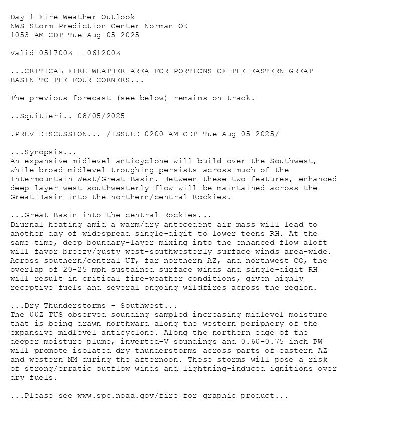
Day 1 Fire Weather Outlook
NWS Storm Prediction Center Norman OK
1053 AM CDT Tue Aug 05 2025
Valid 051700Z - 061200Z
...CRITICAL FIRE WEATHER AREA FOR PORTIONS OF THE EASTERN GREAT
BASIN TO THE FOUR CORNERS...
The previous forecast (see below) remains on track.
..Squitieri.. 08/05/2025
.PREV DISCUSSION... /ISSUED 0200 AM CDT Tue Aug 05 2025/
...Synopsis...
An expansive midlevel anticyclone will build over the Southwest,
while broad midlevel troughing persists across much of the
Intermountain West/Great Basin. Between these two features, enhanced
deep-layer west-southwesterly flow will be maintained across the
Great Basin into the northern/central Rockies.
...Great Basin into the central Rockies...
Diurnal heating amid a warm/dry antecedent air mass will lead to
another day of widespread single-digit to lower teens RH. At the
same time, deep boundary-layer mixing into the enhanced flow aloft
will favor breezy/gusty west-southwesterly surface winds area-wide.
Across southern/central UT, far northern AZ, and northwest CO, the
overlap of 20-25 mph sustained surface winds and single-digit RH
will result in critical fire-weather conditions, given highly
receptive fuels and several ongoing wildfires across the region.
...Dry Thunderstorms - Southwest...
The 00Z TUS observed sounding sampled increasing midlevel moisture
that is being drawn northward along the western periphery of the
expansive midlevel anticyclone. Along the northern edge of the
deeper moisture plume, inverted-V soundings and 0.60-0.75 inch PW
will promote isolated dry thunderstorms across parts of eastern AZ
and western NM during the afternoon. These storms will pose a risk
of strong/erratic outflow winds and lightning-induced ignitions over
dry fuels.
...Please see www.spc.noaa.gov/fire for graphic product...

Day 1 Fire Weather Outlook Image
SPC Day 1 Fire Weather Outlook posted at Tue, 05 Aug 2025 15:54:26 +0000
🔥CRITICAL FIRE WEATHER AREA FOR PORTIONS OF THE EASTERN GREAT
BASIN TO THE FOUR CORNERS🔥
Additional Details Here.
05.08.2025 16:00 — 👍 1 🔁 0 💬 0 📌 0
Day 2 Fire Weather Outlook
NWS Storm Prediction Center Norman OK
0201 AM CDT Tue Aug 05 2025
Valid 061200Z - 071200Z
...CRITICAL FIRE WEATHER AREA FOR EAST-CENTRAL
NEVADA...SOUTHERN/CENTRAL UTAH...AND NORTHWEST COLORADO...
...Synopsis...
Similar to Day 1/Tuesday, enhanced west-southwesterly flow aloft
will remain in place across much of the Great Basin into the
northern/central Rockies -- between an expansive midlevel
anticyclone over the Southwest and an increasingly pronounced
large-scale trough over the Northwest.
...Great Basin into the central Rockies...
The enhanced deep-layer west-southwesterly flow will overspread a
dry/deeply mixed boundary layer during the afternoon. As a result,
10-15 percent RH will develop amid 15-20 mph sustained
west-southwesterly surface winds. The greatest overlap of strong
winds and low RH is expected beneath the core of the stronger
deep-layer flow -- extending from east-central NV across
southern/central UT and northwest CO. Here, the combination of hot,
dry, and breezy conditions atop receptive fuels will favor another
day of critical fire-weather conditions.
...Dry Thunderstorms - Southwest into the central Rockies...
A midlevel moisture plume will expand northeastward from the
Southwest into the central Rockies, supporting isolated diurnally
driven thunderstorms over the higher terrain during the afternoon.
Inverted-V soundings and 0.50-0.75 inch PW will favor mostly dry
storms, which will pose a risk of lightning-induced ignitions and
gusty/erratic outflow winds.
..Weinman.. 08/05/2025
...Please see www.spc.noaa.gov/fire for graphic product...

Day 2 Fire Weather Outlook Image
SPC Day 2 Fire Weather Outlook posted at Tue, 05 Aug 2025 07:02:26 +0000
🔥CRITICAL FIRE WEATHER AREA FOR EAST-CENTRAL
NEVADA🔥
Additional Details Here.
05.08.2025 07:40 — 👍 0 🔁 0 💬 0 📌 0
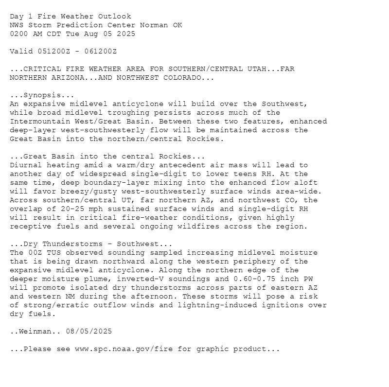
Day 1 Fire Weather Outlook
NWS Storm Prediction Center Norman OK
0200 AM CDT Tue Aug 05 2025
Valid 051200Z - 061200Z
...CRITICAL FIRE WEATHER AREA FOR SOUTHERN/CENTRAL UTAH...FAR
NORTHERN ARIZONA...AND NORTHWEST COLORADO...
...Synopsis...
An expansive midlevel anticyclone will build over the Southwest,
while broad midlevel troughing persists across much of the
Intermountain West/Great Basin. Between these two features, enhanced
deep-layer west-southwesterly flow will be maintained across the
Great Basin into the northern/central Rockies.
...Great Basin into the central Rockies...
Diurnal heating amid a warm/dry antecedent air mass will lead to
another day of widespread single-digit to lower teens RH. At the
same time, deep boundary-layer mixing into the enhanced flow aloft
will favor breezy/gusty west-southwesterly surface winds area-wide.
Across southern/central UT, far northern AZ, and northwest CO, the
overlap of 20-25 mph sustained surface winds and single-digit RH
will result in critical fire-weather conditions, given highly
receptive fuels and several ongoing wildfires across the region.
...Dry Thunderstorms - Southwest...
The 00Z TUS observed sounding sampled increasing midlevel moisture
that is being drawn northward along the western periphery of the
expansive midlevel anticyclone. Along the northern edge of the
deeper moisture plume, inverted-V soundings and 0.60-0.75 inch PW
will promote isolated dry thunderstorms across parts of eastern AZ
and western NM during the afternoon. These storms will pose a risk
of strong/erratic outflow winds and lightning-induced ignitions over
dry fuels.
..Weinman.. 08/05/2025
...Please see www.spc.noaa.gov/fire for graphic product...
Day 1 Fire Weather Outlook Image
SPC Day 1 Fire Weather Outlook posted at Tue, 05 Aug 2025 07:01:27 +0000
🔥CRITICAL FIRE WEATHER AREA FOR SOUTHERN/CENTRAL UTAH🔥
Additional Details Here.
05.08.2025 07:20 — 👍 0 🔁 0 💬 0 📌 0
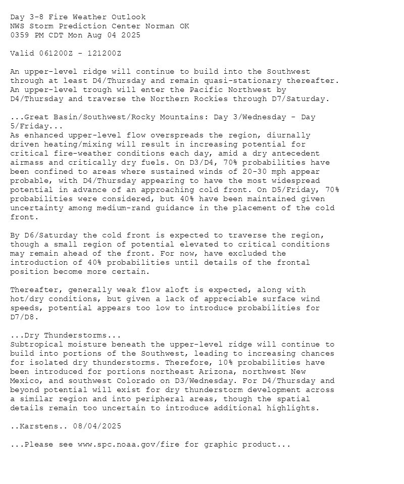
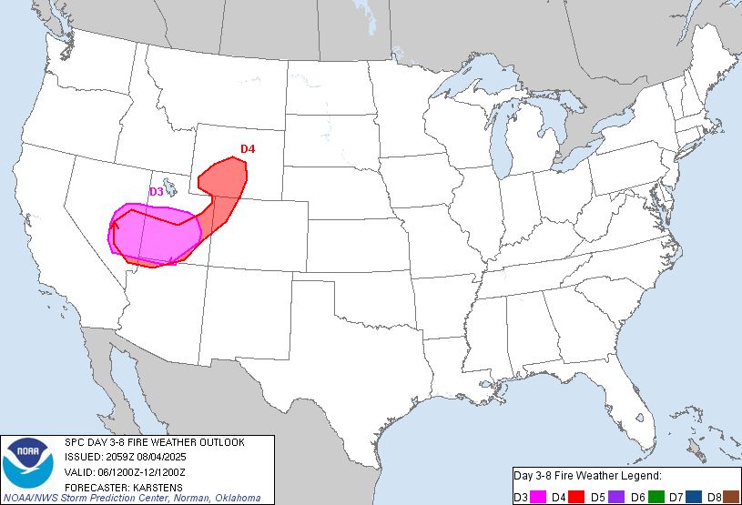
Day 3-8 Fire Weather Outlook
NWS Storm Prediction Center Norman OK
0359 PM CDT Mon Aug 04 2025
Valid 061200Z - 121200Z
An upper-level ridge will continue to build into the Southwest
through at least D4/Thursday and remain quasi-stationary thereafter.
An upper-level trough will enter the Pacific Northwest by
D4/Thursday and traverse the Northern Rockies through D7/Saturday.
...Great Basin/Southwest/Rocky Mountains: Day 3/Wednesday - Day
5/Friday...
As enhanced upper-level flow overspreads the region, diurnally
driven heating/mixing will result in increasing potential for
critical fire-weather conditions each day, amid a dry antecedent
airmass and critically dry fuels. On D3/D4, 70% probabilities have
been confined to areas where sustained winds of 20-30 mph appear
probable, with D4/Thursday appearing to have the most widespread
potential in advance of an approaching cold front. On D5/Friday, 70%
probabilities were considered, but 40% have been maintained given
uncertainty among medium-rand guidance in the placement of the cold
front.
By D6/Saturday the cold front is expected to traverse the region,
though a small region of potential elevated to critical conditions
may remain ahead of the front. For now, have excluded the
introduction of 40% probabilities until details of the frontal
position become more certain.
Thereafter, generally weak flow aloft is expected, along with
hot/dry conditions, but given a lack of appreciable surface wind
speeds, potential appears too low to introduce probabilities for
D7/D8.
...Dry Thunderstorms...
Subtropical moisture beneath the upper-level ridge will continue to
build into portions of the Southwest, leading to increasing chances
for isolated dry thunderstorms. Therefore, 10% probabilities have
been introduced for portions northeast Arizona, northwest New
Mexico, and southwest Colorado on D3/Wednesday. For D4/Thursday and
beyond potential will exist for dry thunderstorm development across
a similar region and into peripheral areas, though the spatial
details remain too uncertain to introduce additional highlights.
..Karstens.. 08/04/2025
...Please see www.spc.noaa.gov/fire for graphic product...
Day 3-8 Fire Weather Outlook Image
SPC Day 3-8 Fire Weather Outlook posted at Mon, 04 Aug 2025 21:04:17 +0000
🔥Great Basin/Southwest/Rocky Mountains: Day 3/Wednesday - Day
5/Friday🔥
Additional Details Here.
04.08.2025 22:40 — 👍 0 🔁 0 💬 0 📌 0
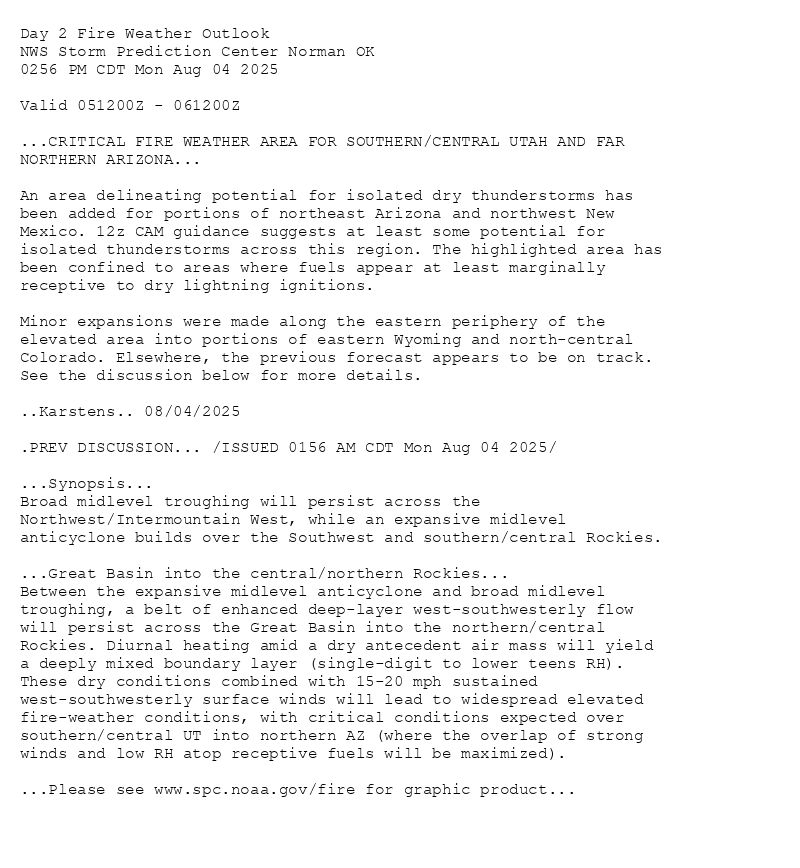
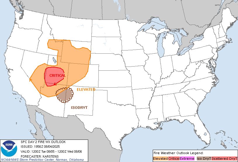
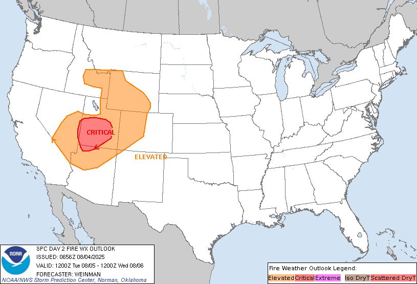
Day 2 Fire Weather Outlook
NWS Storm Prediction Center Norman OK
0256 PM CDT Mon Aug 04 2025
Valid 051200Z - 061200Z
...CRITICAL FIRE WEATHER AREA FOR SOUTHERN/CENTRAL UTAH AND FAR
NORTHERN ARIZONA...
An area delineating potential for isolated dry thunderstorms has
been added for portions of northeast Arizona and northwest New
Mexico. 12z CAM guidance suggests at least some potential for
isolated thunderstorms across this region. The highlighted area has
been confined to areas where fuels appear at least marginally
receptive to dry lightning ignitions.
Minor expansions were made along the eastern periphery of the
elevated area into portions of eastern Wyoming and north-central
Colorado. Elsewhere, the previous forecast appears to be on track.
See the discussion below for more details.
..Karstens.. 08/04/2025
.PREV DISCUSSION... /ISSUED 0156 AM CDT Mon Aug 04 2025/
...Synopsis...
Broad midlevel troughing will persist across the
Northwest/Intermountain West, while an expansive midlevel
anticyclone builds over the Southwest and southern/central Rockies.
...Great Basin into the central/northern Rockies...
Between the expansive midlevel anticyclone and broad midlevel
troughing, a belt of enhanced deep-layer west-southwesterly flow
will persist across the Great Basin into the northern/central
Rockies. Diurnal heating amid a dry antecedent air mass will yield
a deeply mixed boundary layer (single-digit to lower teens RH).
These dry conditions combined with 15-20 mph sustained
west-southwesterly surface winds will lead to widespread elevated
fire-weather conditions, with critical conditions expected over
southern/central UT into northern AZ (where the overlap of strong
winds and low RH atop receptive fuels will be maximized).
...Please see www.spc.noaa.gov/fire for graphic product...
Day 2 Fire Weather Outlook Image
SPC Day 2 Fire Weather Outlook posted at Mon, 04 Aug 2025 19:58:26 +0000
🔥CRITICAL FIRE WEATHER AREA FOR SOUTHERN/CENTRAL UTAH AND FAR
NORTHERN ARIZONA🔥
Additional Details Here.
04.08.2025 22:40 — 👍 0 🔁 0 💬 0 📌 0
Day 1 Fire Weather Outlook
NWS Storm Prediction Center Norman OK
1138 AM CDT Mon Aug 04 2025
Valid 041700Z - 051200Z
...CRITICAL FIRE WEATHER AREA FOR PARTS OF THE GREAT BASIN INTO THE
CENTRAL ROCKIES...
A minor expansion of the area delineating potential for isolated dry
thunderstorms was made into parts of far northern Nevada and central
Oregon. Some potential for scattered dry thunderstorms exists within
this region, though confined to areas where fuels appear more
marginally receptive to dry lightning ignitions.
The balance of the previous forecast generally remains on track.
Breezy northwest winds across portions of northwest California may
result in brief/localized elevated conditions. Otherwise, see the
discussion below for more details.
..Karstens.. 08/04/2025
.PREV DISCUSSION... /ISSUED 0156 AM CDT Mon Aug 04 2025/
...Synopsis...
Along the northwestern periphery of a large-scale ridge extending
from the Southwest into the northern Plains, a compact/robust
midlevel trough will advance east-northeastward from the Northwest
into the northern Rockies during the day.
...Great Basin into the central Rockies...
Between the large-scale ridge and midlevel trough, a belt of
moderate deep-layer west-southwesterly flow will overspread the
Great Basin into the central Rockies through the afternoon. Here,
deep boundary-layer mixing into the enhanced flow aloft will favor
widespread single-digit RH and 15-25 mph sustained
west-southwesterly surface winds. These dry/windy conditions will
lead to critical fire-weather conditions across much of UT and
adjacent states, given very receptive fuels.
...Dry Thunderstorms - Intermountain West/Northern Rockies...
Strong/focused forcing for ascent accompanying the midlevel trough
will aid in thunderstorm development across much of the
Intermountain West and northern Rockies throughout the day. Along
the southern periphery of deeper midlevel moisture across parts of
the Northwest into the northern Rockies, isolated high-based
thunderstorms are expected in an air mass characterized by 0.60-0.75
inch PW and inverted-V soundings. This will promote mostly dry
thunderstorms with a risk of lightning-induced ignitions and
strong-severe outflow winds. Reference the SPC Day 1 Convective
Outlook for information on the severe risk.
...Please see www.spc.noaa.gov/fire for graphic product...

Day 1 Fire Weather Outlook Image
SPC Day 1 Fire Weather Outlook posted at Mon, 04 Aug 2025 16:40:27 +0000
🔥CRITICAL FIRE WEATHER AREA FOR PARTS OF THE GREAT BASIN INTO THE
CENTRAL ROCKIES🔥
Additional Details Here.
04.08.2025 17:00 — 👍 1 🔁 0 💬 0 📌 0
Day 2 Fire Weather Outlook
NWS Storm Prediction Center Norman OK
0156 AM CDT Mon Aug 04 2025
Valid 051200Z - 061200Z
...CRITICAL FIRE WEATHER AREA FOR SOUTHERN/CENTRAL UTAH AND FAR
NORTHERN ARIZONA...
...Synopsis...
Broad midlevel troughing will persist across the
Northwest/Intermountain West, while an expansive midlevel
anticyclone builds over the Southwest and southern/central Rockies.
...Great Basin into the central/northern Rockies...
Between the expansive midlevel anticyclone and broad midlevel
troughing, a belt of enhanced deep-layer west-southwesterly flow
will persist across the Great Basin into the northern/central
Rockies. Diurnal heating amid a dry antecedent air mass will yield
a deeply mixed boundary layer (single-digit to lower teens RH).
These dry conditions combined with 15-20 mph sustained
west-southwesterly surface winds will lead to widespread elevated
fire-weather conditions, with critical conditions expected over
southern/central UT into northern AZ (where the overlap of strong
winds and low RH atop receptive fuels will be maximized).
..Weinman.. 08/04/2025
...Please see www.spc.noaa.gov/fire for graphic product...
Day 2 Fire Weather Outlook Image
SPC Day 2 Fire Weather Outlook posted at Mon, 04 Aug 2025 06:59:13 +0000
🔥CRITICAL FIRE WEATHER AREA FOR SOUTHERN/CENTRAL UTAH AND FAR
NORTHERN ARIZONA🔥
Additional Details Here.
04.08.2025 07:20 — 👍 0 🔁 0 💬 0 📌 0
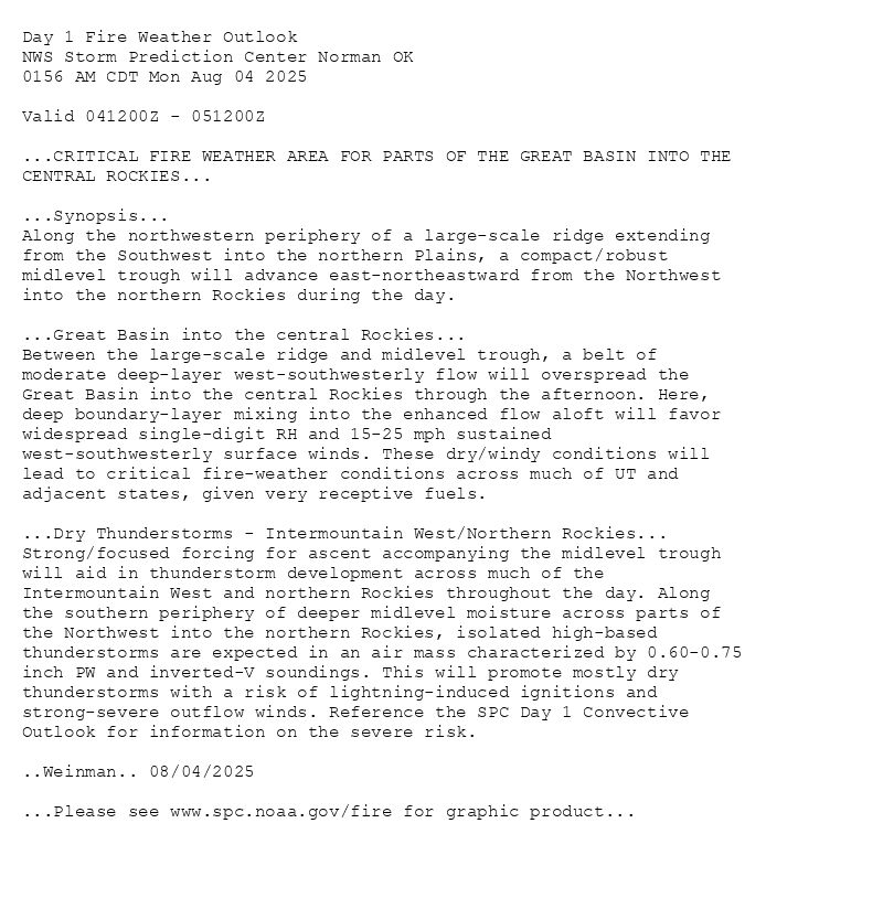
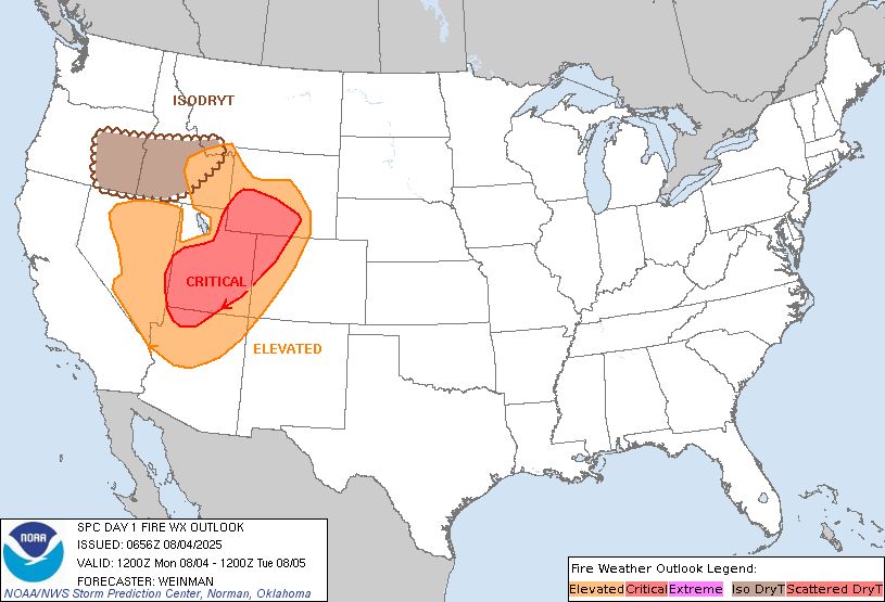
Day 1 Fire Weather Outlook
NWS Storm Prediction Center Norman OK
0156 AM CDT Mon Aug 04 2025
Valid 041200Z - 051200Z
...CRITICAL FIRE WEATHER AREA FOR PARTS OF THE GREAT BASIN INTO THE
CENTRAL ROCKIES...
...Synopsis...
Along the northwestern periphery of a large-scale ridge extending
from the Southwest into the northern Plains, a compact/robust
midlevel trough will advance east-northeastward from the Northwest
into the northern Rockies during the day.
...Great Basin into the central Rockies...
Between the large-scale ridge and midlevel trough, a belt of
moderate deep-layer west-southwesterly flow will overspread the
Great Basin into the central Rockies through the afternoon. Here,
deep boundary-layer mixing into the enhanced flow aloft will favor
widespread single-digit RH and 15-25 mph sustained
west-southwesterly surface winds. These dry/windy conditions will
lead to critical fire-weather conditions across much of UT and
adjacent states, given very receptive fuels.
...Dry Thunderstorms - Intermountain West/Northern Rockies...
Strong/focused forcing for ascent accompanying the midlevel trough
will aid in thunderstorm development across much of the
Intermountain West and northern Rockies throughout the day. Along
the southern periphery of deeper midlevel moisture across parts of
the Northwest into the northern Rockies, isolated high-based
thunderstorms are expected in an air mass characterized by 0.60-0.75
inch PW and inverted-V soundings. This will promote mostly dry
thunderstorms with a risk of lightning-induced ignitions and
strong-severe outflow winds. Reference the SPC Day 1 Convective
Outlook for information on the severe risk.
..Weinman.. 08/04/2025
...Please see www.spc.noaa.gov/fire for graphic product...
Day 1 Fire Weather Outlook Image
SPC Day 1 Fire Weather Outlook posted at Mon, 04 Aug 2025 06:58:26 +0000
🔥CRITICAL FIRE WEATHER AREA FOR PARTS OF THE GREAT BASIN INTO THE
CENTRAL ROCKIES🔥
Additional Details Here.
04.08.2025 07:20 — 👍 0 🔁 0 💬 0 📌 0
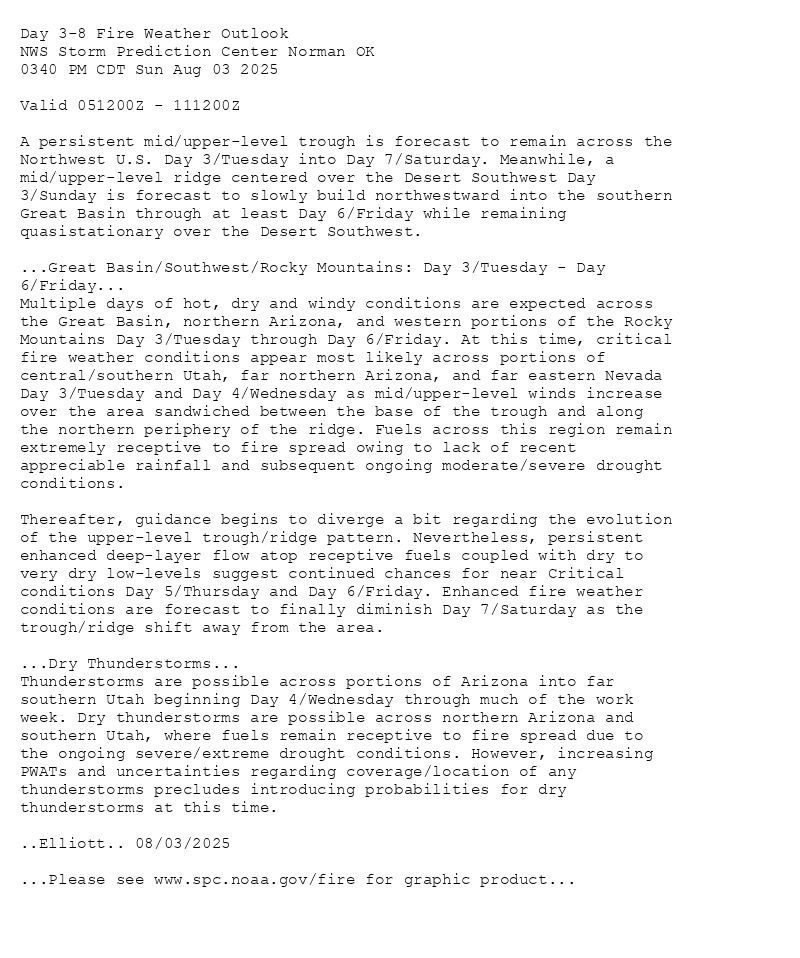
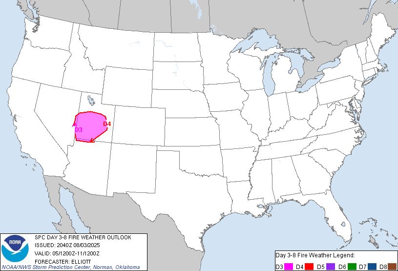
Day 3-8 Fire Weather Outlook
NWS Storm Prediction Center Norman OK
0340 PM CDT Sun Aug 03 2025
Valid 051200Z - 111200Z
A persistent mid/upper-level trough is forecast to remain across the
Northwest U.S. Day 3/Tuesday into Day 7/Saturday. Meanwhile, a
mid/upper-level ridge centered over the Desert Southwest Day
3/Sunday is forecast to slowly build northwestward into the southern
Great Basin through at least Day 6/Friday while remaining
quasistationary over the Desert Southwest.
...Great Basin/Southwest/Rocky Mountains: Day 3/Tuesday - Day
6/Friday...
Multiple days of hot, dry and windy conditions are expected across
the Great Basin, northern Arizona, and western portions of the Rocky
Mountains Day 3/Tuesday through Day 6/Friday. At this time, critical
fire weather conditions appear most likely across portions of
central/southern Utah, far northern Arizona, and far eastern Nevada
Day 3/Tuesday and Day 4/Wednesday as mid/upper-level winds increase
over the area sandwiched between the base of the trough and along
the northern periphery of the ridge. Fuels across this region remain
extremely receptive to fire spread owing to lack of recent
appreciable rainfall and subsequent ongoing moderate/severe drought
conditions.
Thereafter, guidance begins to diverge a bit regarding the evolution
of the upper-level trough/ridge pattern. Nevertheless, persistent
enhanced deep-layer flow atop receptive fuels coupled with dry to
very dry low-levels suggest continued chances for near Critical
conditions Day 5/Thursday and Day 6/Friday. Enhanced fire weather
conditions are forecast to finally diminish Day 7/Saturday as the
trough/ridge shift away from the area.
...Dry Thunderstorms...
Thunderstorms are possible across portions of Arizona into far
southern Utah beginning Day 4/Wednesday through much of the work
week. Dry thunderstorms are possible across northern Arizona and
southern Utah, where fuels remain receptive to fire spread due to
the ongoing severe/extreme drought conditions. However, increasing
PWATs and uncertainties regarding coverage/location of any
thunderstorms precludes introducing probabilities for dry
thunderstorms at this time.
..Elliott.. 08/03/2025
...Please see www.spc.noaa.gov/fire for graphic product...
Day 3-8 Fire Weather Outlook Image
SPC Day 3-8 Fire Weather Outlook posted at Sun, 03 Aug 2025 20:45:16 +0000
🔥Great Basin/Southwest/Rocky Mountains: Day 3/Tuesday - Day
6/Friday🔥
Additional Details Here.
04.08.2025 01:00 — 👍 1 🔁 0 💬 0 📌 0
Day 2 Fire Weather Outlook
NWS Storm Prediction Center Norman OK
0150 PM CDT Sun Aug 03 2025
Valid 041200Z - 051200Z
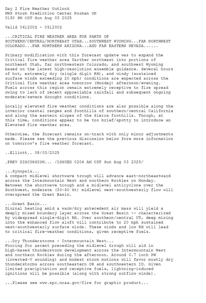
...CRITICAL FIRE WEATHER AREA FOR PARTS OF
SOUTHERN/CENTRAL/NORTHEAST UTAH...SOUTHWEST WYOMING...FAR NORTHWEST
COLORADO...FAR NORTHERN ARIZONA...AND FAR EASTERN NEVADA......
Primary modification with this forecast update was to expand the
Critical fire weather area farther northeast into portions of
northeast Utah, far northwestern Colorado, and southwest Wyoming
based on the latest high-resolution ensemble guidance. Several hours
of hot, extremely dry (single digit RH), and windy (sustained
surface winds exceeding 20 mph) conditions are expected across the
Critical fire weather area tomorrow (Monday) afternoon/evening.
Fuels across this region remain extremely receptive to fire spread
owing to lack of recent appreciable rainfall and subsequent ongoing
moderate/severe drought conditions.
Locally elevated fire weather conditions are also possible along the
interior coastal ranges and foothills of southern/central California
and along the eastern slopes of the Sierra foothills. Though, at
this time, conditions appear to be too brief/spotty to introduce an
Elevated fire weather area.
Otherwise, the forecast remains on-track with only minor adjustments
made. Please see the previous discussion below fore more information
on tomorrow's fire weather forecast.
..Elliott.. 08/03/2025
.PREV DISCUSSION... /ISSUED 0204 AM CDT Sun Aug 03 2025/
...Synopsis...
A compact midlevel shortwave trough will advance east-northeastward
across the Intermountain West and northern Rockies on Monday.
Between the shortwave trough and a midlevel anticyclone over the
Southwest, moderate (30-40 kt) midlevel west-southwesterly flow will
overspread the Great Basin.
...Great Basin...
Diurnal heating amid a warm/dry antecedent air mass will yield a
deeply mixed boundary layer across the Great Basin -- characterized
by widespread single-digit RH. Over southern/central UT, deep mixing
into the enhanced flow aloft will contribute to 20 mph sustained
west-southwesterly surface winds. These winds and low RH will lead
to critical fire-weather conditions, given receptive fuels.
...Dry Thunderstorms - Intermountain West...
Forcing for ascent preceding the midlevel trough will aid in
high-based thunderstorm development across the Intermountain West
and northern Rockies during the afternoon. Around 0.7 inch PW
(inverted-V sounding) and modest storm motions will favor mostly dry
thunderstorms across southeastern OR and southwestern ID. Given
limited precipitation and receptive fuels, lightning-induced
ignitions will be possible (along with strong outflow winds).
...Please see www.spc.noaa.gov/fire for graphic product...
Day 2 Fire Weather Outlook Image
SPC Day 2 Fire Weather Outlook posted at Sun, 03 Aug 2025 18:52:26 +0000
🔥CRITICAL FIRE WEATHER AREA FOR PARTS OF
SOUTHERN/CENTRAL/NORTHEAST UTAH🔥
Additional Details Here.
03.08.2025 19:20 — 👍 0 🔁 0 💬 0 📌 0
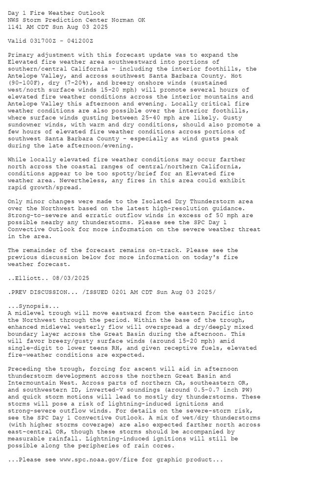
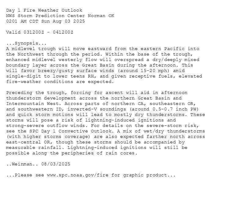
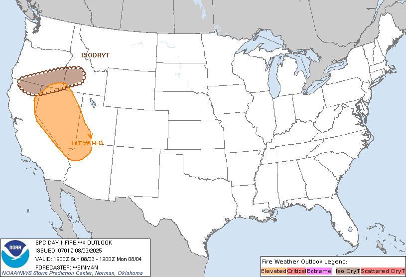
Day 1 Fire Weather Outlook
NWS Storm Prediction Center Norman OK
1141 AM CDT Sun Aug 03 2025
Valid 031700Z - 041200Z
Primary adjustment with this forecast update was to expand the
Elevated fire weather area southwestward into portions of
southern/central California - including the interior foothills, the
Antelope Valley, and across southwest Santa Barbara County. Hot
(90-100F), dry (7-20%), and breezy onshore winds (sustained
west/north surface winds 15-20 mph) will promote several hours of
elevated fire weather conditions across the interior mountains and
Antelope Valley this afternoon and evening. Locally critical fire
weather conditions are also possible over the interior foothills,
where surface winds gusting between 25-40 mph are likely. Gusty
sundowner winds, with warm and dry conditions, should also promote a
few hours of elevated fire weather conditions across portions of
southwest Santa Barbara County - especially as wind gusts peak
during the late afternoon/evening.
While locally elevated fire weather conditions may occur farther
north across the coastal ranges of central/northern California,
conditions appear to be too spotty/brief for an Elevated fire
weather area. Nevertheless, any fires in this area could exhibit
rapid growth/spread.
Only minor changes were made to the Isolated Dry Thunderstorm area
over the Northwest based on the latest high-resolution guidance.
Strong-to-severe and erratic outflow winds in excess of 50 mph are
possible nearby any thunderstorms. Please see the SPC Day 1
Convective Outlook for more information on the severe weather threat
in the area.
The remainder of the forecast remains on-track. Please see the
previous discussion below for more information on today's fire
weather forecast.
..Elliott.. 08/03/2025
.PREV DISCUSSION... /ISSUED 0201 AM CDT Sun Aug 03 2025/
...Synopsis...
A midlevel trough will move eastward from the eastern Pacific into
the Northwest through the period. Within the base of the trough,
enhanced midlevel westerly flow will overspread a dry/deeply mixed
boundary layer across the Great Basin during the afternoon. This
will favor breezy/gusty surface winds (around 15-20 mph) amid
single-digit to lower teens RH, and given receptive fuels, elevated
fire-weather conditions are expected.
Preceding the trough, forcing for ascent will aid in afternoon
thunderstorm development across the northern Great Basin and
Intermountain West. Across parts of northern CA, southeastern OR,
and southwestern ID, inverted-V soundings (around 0.5-0.7 inch PW)
and quick storm motions will lead to mostly dry thunderstorms. These
storms will pose a risk of lightning-induced ignitions and
strong-severe outflow winds. For details on the severe-storm risk,
see the SPC Day 1 Convective Outlook. A mix of wet/dry thunderstorms
(with higher storms coverage) are also expected farther north across
east-central OR, though these storms should be accompanied by
measurable rainfall. Lightning-induced ignitions will still be
possible along the peripheries of rain cores.
...Please see www.spc.noaa.gov/fire for graphic product...
Day 1 Fire Weather Outlook Image
SPC Day 1 Fire Weather Outlook posted at Sun, 03 Aug 2025 16:43:26 +0000
🔥 /ISSUED 0201 AM CDT Sun Aug 03 2025/
🔥
Additional Details Here.
03.08.2025 17:00 — 👍 0 🔁 0 💬 0 📌 0
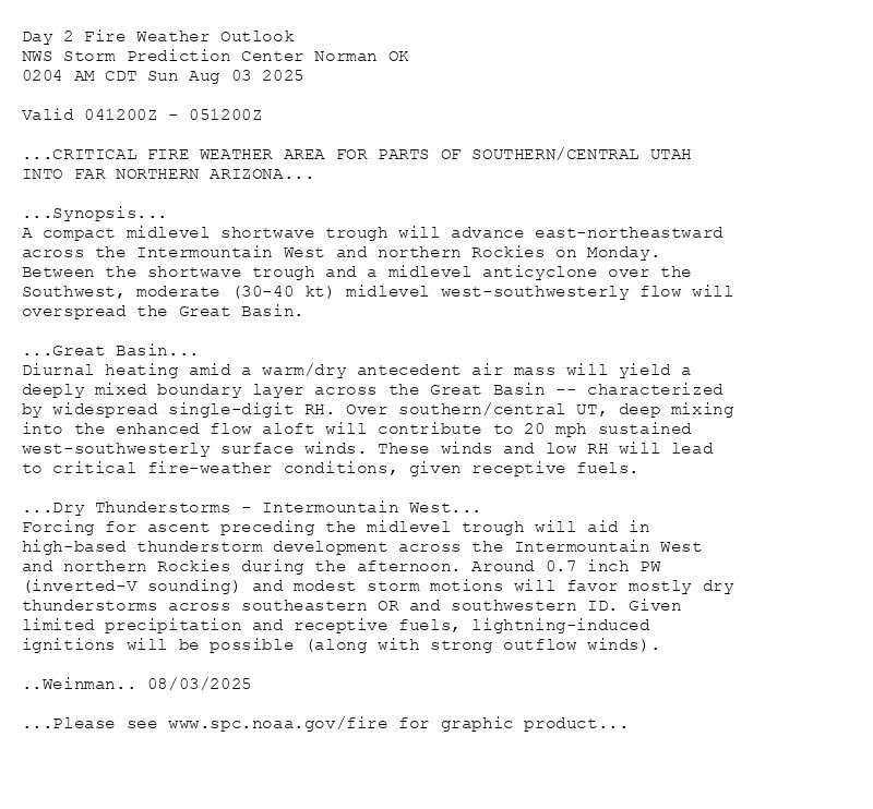
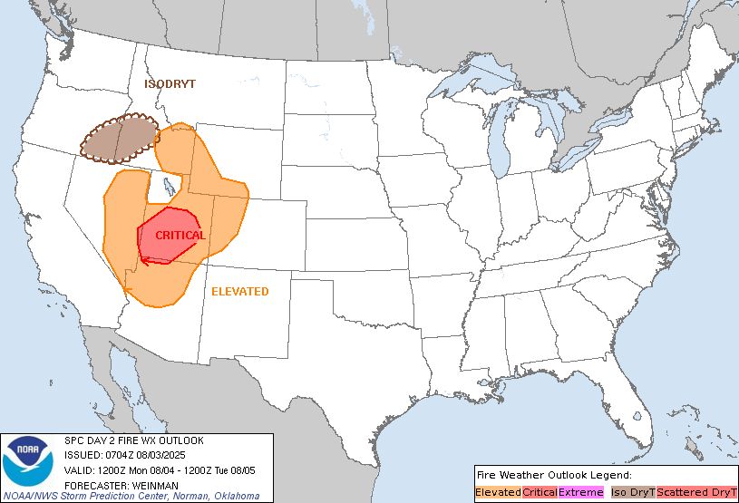
Day 2 Fire Weather Outlook
NWS Storm Prediction Center Norman OK
0204 AM CDT Sun Aug 03 2025
Valid 041200Z - 051200Z
...CRITICAL FIRE WEATHER AREA FOR PARTS OF SOUTHERN/CENTRAL UTAH
INTO FAR NORTHERN ARIZONA...
...Synopsis...
A compact midlevel shortwave trough will advance east-northeastward
across the Intermountain West and northern Rockies on Monday.
Between the shortwave trough and a midlevel anticyclone over the
Southwest, moderate (30-40 kt) midlevel west-southwesterly flow will
overspread the Great Basin.
...Great Basin...
Diurnal heating amid a warm/dry antecedent air mass will yield a
deeply mixed boundary layer across the Great Basin -- characterized
by widespread single-digit RH. Over southern/central UT, deep mixing
into the enhanced flow aloft will contribute to 20 mph sustained
west-southwesterly surface winds. These winds and low RH will lead
to critical fire-weather conditions, given receptive fuels.
...Dry Thunderstorms - Intermountain West...
Forcing for ascent preceding the midlevel trough will aid in
high-based thunderstorm development across the Intermountain West
and northern Rockies during the afternoon. Around 0.7 inch PW
(inverted-V sounding) and modest storm motions will favor mostly dry
thunderstorms across southeastern OR and southwestern ID. Given
limited precipitation and receptive fuels, lightning-induced
ignitions will be possible (along with strong outflow winds).
..Weinman.. 08/03/2025
...Please see www.spc.noaa.gov/fire for graphic product...
Day 2 Fire Weather Outlook Image
SPC Day 2 Fire Weather Outlook posted at Sun, 03 Aug 2025 07:05:27 +0000
🔥CRITICAL FIRE WEATHER AREA FOR PARTS OF SOUTHERN/CENTRAL UTAH
INTO FAR NORTHERN ARIZONA🔥
Additional Details Here.
03.08.2025 07:20 — 👍 0 🔁 0 💬 0 📌 0
Day 1 Fire Weather Outlook
NWS Storm Prediction Center Norman OK
0201 AM CDT Sun Aug 03 2025
Valid 031200Z - 041200Z
...Synopsis...
A midlevel trough will move eastward from the eastern Pacific into
the Northwest through the period. Within the base of the trough,
enhanced midlevel westerly flow will overspread a dry/deeply mixed
boundary layer across the Great Basin during the afternoon. This
will favor breezy/gusty surface winds (around 15-20 mph) amid
single-digit to lower teens RH, and given receptive fuels, elevated
fire-weather conditions are expected.
Preceding the trough, forcing for ascent will aid in afternoon
thunderstorm development across the northern Great Basin and
Intermountain West. Across parts of northern CA, southeastern OR,
and southwestern ID, inverted-V soundings (around 0.5-0.7 inch PW)
and quick storm motions will lead to mostly dry thunderstorms. These
storms will pose a risk of lightning-induced ignitions and
strong-severe outflow winds. For details on the severe-storm risk,
see the SPC Day 1 Convective Outlook. A mix of wet/dry thunderstorms
(with higher storms coverage) are also expected farther north across
east-central OR, though these storms should be accompanied by
measurable rainfall. Lightning-induced ignitions will still be
possible along the peripheries of rain cores.
..Weinman.. 08/03/2025
...Please see www.spc.noaa.gov/fire for graphic product...
Day 1 Fire Weather Outlook Image
SPC Day 1 Fire Weather Outlook posted at Sun, 03 Aug 2025 07:02:26 +0000
🔥Synopsis🔥
Additional Details Here.
03.08.2025 07:20 — 👍 0 🔁 0 💬 0 📌 0
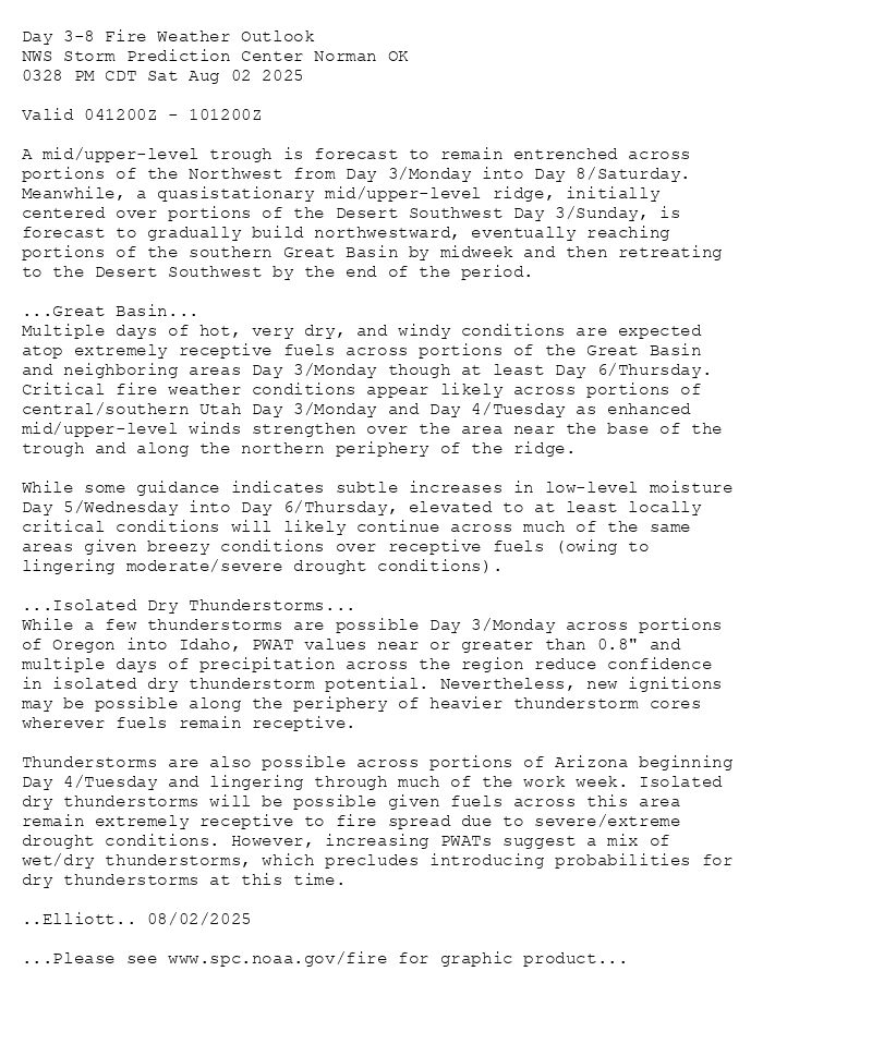
Day 3-8 Fire Weather Outlook
NWS Storm Prediction Center Norman OK
0328 PM CDT Sat Aug 02 2025
Valid 041200Z - 101200Z
A mid/upper-level trough is forecast to remain entrenched across
portions of the Northwest from Day 3/Monday into Day 8/Saturday.
Meanwhile, a quasistationary mid/upper-level ridge, initially
centered over portions of the Desert Southwest Day 3/Sunday, is
forecast to gradually build northwestward, eventually reaching
portions of the southern Great Basin by midweek and then retreating
to the Desert Southwest by the end of the period.
...Great Basin...
Multiple days of hot, very dry, and windy conditions are expected
atop extremely receptive fuels across portions of the Great Basin
and neighboring areas Day 3/Monday though at least Day 6/Thursday.
Critical fire weather conditions appear likely across portions of
central/southern Utah Day 3/Monday and Day 4/Tuesday as enhanced
mid/upper-level winds strengthen over the area near the base of the
trough and along the northern periphery of the ridge.
While some guidance indicates subtle increases in low-level moisture
Day 5/Wednesday into Day 6/Thursday, elevated to at least locally
critical conditions will likely continue across much of the same
areas given breezy conditions over receptive fuels (owing to
lingering moderate/severe drought conditions).
...Isolated Dry Thunderstorms...
While a few thunderstorms are possible Day 3/Monday across portions
of Oregon into Idaho, PWAT values near or greater than 0.8" and
multiple days of precipitation across the region reduce confidence
in isolated dry thunderstorm potential. Nevertheless, new ignitions
may be possible along the periphery of heavier thunderstorm cores
wherever fuels remain receptive.
Thunderstorms are also possible across portions of Arizona beginning
Day 4/Tuesday and lingering through much of the work week. Isolated
dry thunderstorms will be possible given fuels across this area
remain extremely receptive to fire spread due to severe/extreme
drought conditions. However, increasing PWATs suggest a mix of
wet/dry thunderstorms, which precludes introducing probabilities for
dry thunderstorms at this time.
..Elliott.. 08/02/2025
...Please see www.spc.noaa.gov/fire for graphic product...
Day 3-8 Fire Weather Outlook Image
SPC Day 3-8 Fire Weather Outlook posted at Sat, 02 Aug 2025 20:33:16 +0000
🔥Great Basin🔥
Additional Details Here.
02.08.2025 21:40 — 👍 1 🔁 0 💬 0 📌 0
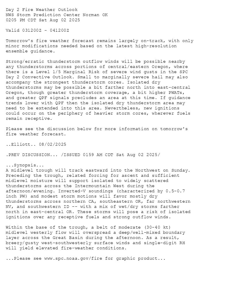
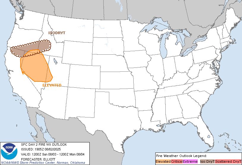
Day 2 Fire Weather Outlook
NWS Storm Prediction Center Norman OK
0205 PM CDT Sat Aug 02 2025
Valid 031200Z - 041200Z
Tomorrow's fire weather forecast remains largely on-track, with only
minor modifications needed based on the latest high-resolution
ensemble guidance.
Strong/erratic thunderstorm outflow winds will be possible nearby
any thunderstorms across portions of central/eastern Oregon, where
there is a Level 1/5 Marginal Risk of severe wind gusts in the SPC
Day 2 Convective Outlook. Small to marginally severe hail may also
accompany the strongest thunderstorm cores. Isolated dry
thunderstorms may be possible a bit farther north into east-central
Oregon, though greater thunderstorm coverage, a bit higher PWATs,
and greater QPF signals precludes an area at this time. If guidance
trends lower with QPF then the isolated dry thunderstorm area may
need to be extended into this area. Nevertheless, new ignitions
could occur on the periphery of heavier storm cores, wherever fuels
remain receptive.
Please see the discussion below for more information on tomorrow's
fire weather forecast.
..Elliott.. 08/02/2025
.PREV DISCUSSION... /ISSUED 0159 AM CDT Sat Aug 02 2025/
...Synopsis...
A midlevel trough will track eastward into the Northwest on Sunday.
Preceding the trough, related forcing for ascent and sufficient
midlevel moisture will support isolated to widely scattered
thunderstorms across the Intermountain West during the
afternoon/evening. Inverted-V soundings (characterized by 0.5-0.7
inch PW) and modest storm motions will favor mostly dry
thunderstorms across northern CA, southeastern OR, far northwestern
NV, and southwestern ID -- with a mix of wet/dry storms farther
north in east-central OR. These storms will pose a risk of isolated
ignitions over any receptive fuels and strong outflow winds.
Within the base of the trough, a belt of moderate (30-40 kt)
midlevel westerly flow will overspread a deep/well-mixed boundary
layer across the Great Basin during the afternoon. As a result,
breezy/gusty west-southwesterly surface winds and single-digit RH
will yield elevated fire-weather conditions.
...Please see www.spc.noaa.gov/fire for graphic product...
Day 2 Fire Weather Outlook Image
SPC Day 2 Fire Weather Outlook posted at Sat, 02 Aug 2025 19:06:26 +0000
🔥 /ISSUED 0159 AM CDT Sat Aug 02 2025/
🔥
Additional Details Here.
02.08.2025 19:20 — 👍 1 🔁 0 💬 0 📌 0
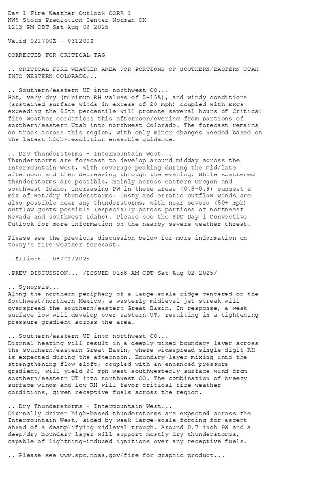
Day 1 Fire Weather Outlook CORR 1
NWS Storm Prediction Center Norman OK
1213 PM CDT Sat Aug 02 2025
Valid 021700Z - 031200Z
CORRECTED FOR CRITICAL TAG
...CRITICAL FIRE WEATHER AREA FOR PORTIONS OF SOUTHERN/EASTERN UTAH
INTO WESTERN COLORADO...
...Southern/eastern UT into northwest CO...
Hot, very dry (minimum RH values of 5-15%), and windy conditions
(sustained surface winds in excess of 20 mph) coupled with ERCs
exceeding the 95th percentile will promote several hours of Critical
fire weather conditions this afternoon/evening from portions of
southern/eastern Utah into northwest Colorado. The forecast remains
on track across this region, with only minor changes needed based on
the latest high-resolution ensemble guidance.
...Dry Thunderstorms - Intermountain West...
Thunderstorms are forecast to develop around midday across the
Intermountain West, with coverage peaking during the mid/late
afternoon and then decreasing through the evening. While scattered
thunderstorms are possible, mainly across eastern Oregon and
southwest Idaho, increasing PW in these areas (0.8-0.9) suggest a
mix of wet/dry thunderstorms. Gusty and erratic outflow winds are
also possible near any thunderstorms, with near severe (50+ mph)
outflow gusts possible (especially across portions of northeast
Nevada and southwest Idaho). Please see the SPC Day 1 Convective
Outlook for more information on the nearby severe weather threat.
Please see the previous discussion below for more information on
today's fire weather forecast.
..Elliott.. 08/02/2025
.PREV DISCUSSION... /ISSUED 0158 AM CDT Sat Aug 02 2025/
...Synopsis...
Along the northern periphery of a large-scale ridge centered on the
Southwest/northern Mexico, a westerly midlevel jet streak will
overspread the southern/eastern Great Basin. In response, a weak
surface low will develop over eastern UT, resulting in a tightening
pressure gradient across the area.
...Southern/eastern UT into northwest CO...
Diurnal heating will result in a deeply mixed boundary layer across
the southern/eastern Great Basin, where widespread single-digit RH
is expected during the afternoon. Boundary-layer mixing into the
strengthening flow aloft, coupled with an enhanced pressure
gradient, will yield 20 mph west-southwesterly surface wind from
southern/eastern UT into northwest CO. The combination of breezy
surface winds and low RH will favor critical fire-weather
conditions, given receptive fuels across the region.
...Dry Thunderstorms - Intermountain West...
Diurnally driven high-based thunderstorms are expected across the
Intermountain West, aided by weak large-scale forcing for ascent
ahead of a deamplifying midlevel trough. Around 0.7 inch PW and a
deep/dry boundary layer will support mostly dry thunderstorms,
capable of lightning-induced ignitions over any receptive fuels.
...Please see www.spc.noaa.gov/fire for graphic product...
Day 1 Fire Weather Outlook Image
SPC Day 1 Fire Weather Outlook posted at Sat, 02 Aug 2025 17:15:27 +0000
🔥CRITICAL FIRE WEATHER AREA FOR PORTIONS OF SOUTHERN/EASTERN UTAH
INTO WESTERN COLORADO🔥
Additional Details Here.
02.08.2025 17:20 — 👍 0 🔁 0 💬 0 📌 0
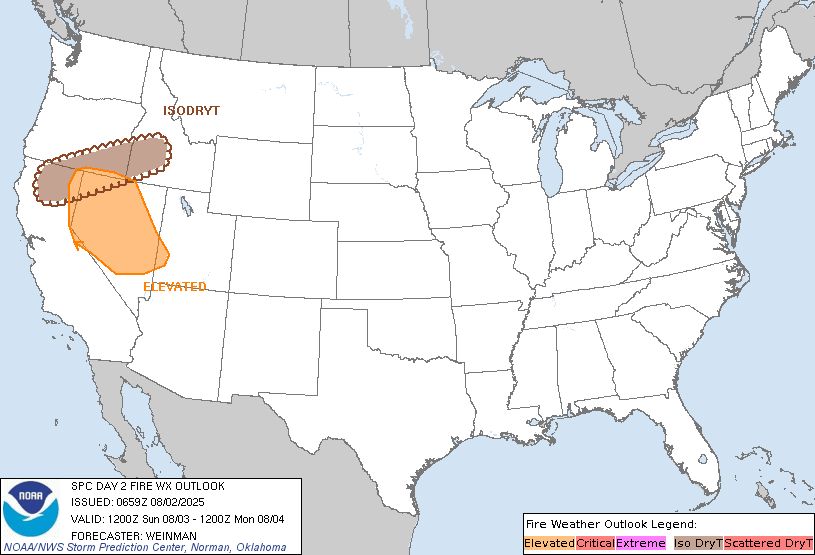
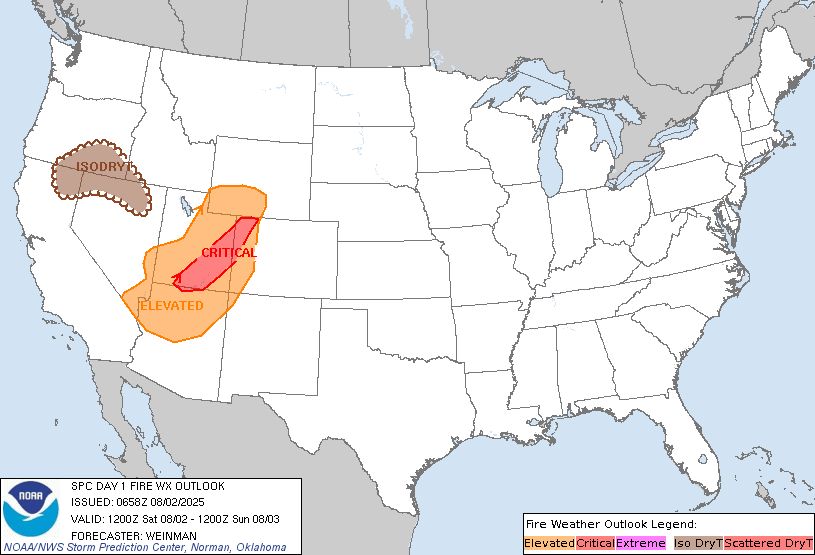
Day 1 Fire Weather Outlook
NWS Storm Prediction Center Norman OK
1136 AM CDT Sat Aug 02 2025
Valid 021700Z - 031200Z
...Southern/eastern UT into northwest CO...
Hot, very dry (minimum RH values of 5-15%), and windy conditions
(sustained surface winds in excess of 20 mph) coupled with ERCs
exceeding the 95th percentile will promote several hours of Critical
fire weather conditions this afternoon/evening from portions of
southern/eastern Utah into northwest Colorado. The forecast remains
on track across this region, with only minor changes needed based on
the latest high-resolution ensemble guidance.
...Dry Thunderstorms - Intermountain West...
Thunderstorms are forecast to develop around midday across the
Intermountain West, with coverage peaking during the mid/late
afternoon and then decreasing through the evening. While scattered
thunderstorms are possible, mainly across eastern Oregon and
southwest Idaho, increasing PW in these areas (0.8-0.9) suggest a
mix of wet/dry thunderstorms. Gusty and erratic outflow winds are
also possible near any thunderstorms, with near severe (50+ mph)
outflow gusts possible (especially across portions of northeast
Nevada and southwest Idaho). Please see the SPC Day 1 Convective
Outlook for more information on the nearby severe weather threat.
Please see the previous discussion below for more information on
today's fire weather forecast.
..Elliott.. 08/02/2025
.PREV DISCUSSION... /ISSUED 0158 AM CDT Sat Aug 02 2025/
...Synopsis...
Along the northern periphery of a large-scale ridge centered on the
Southwest/northern Mexico, a westerly midlevel jet streak will
overspread the southern/eastern Great Basin. In response, a weak
surface low will develop over eastern UT, resulting in a tightening
pressure gradient across the area.
...Southern/eastern UT into northwest CO...
Diurnal heating will result in a deeply mixed boundary layer across
the southern/eastern Great Basin, where widespread single-digit RH
is expected during the afternoon. Boundary-layer mixing into the
strengthening flow aloft, coupled with an enhanced pressure
gradient, will yield 20 mph west-southwesterly surface wind from
southern/eastern UT into northwest CO. The combination of breezy
surface winds and low RH will favor critical fire-weather
conditions, given receptive fuels across the region.
...Dry Thunderstorms - Intermountain West...
Diurnally driven high-based thunderstorms are expected across the
Intermountain West, aided by weak large-scale forcing for ascent
ahead of a deamplifying midlevel trough. Around 0.7 inch PW and a
deep/dry boundary layer will support mostly dry thunderstorms,
capable of lightning-induced ignitions over any receptive fuels.
...Please see www.spc.noaa.gov/fire for graphic product...

Day 1 Fire Weather Outlook Image
SPC Day 1 Fire Weather Outlook posted at Sat, 02 Aug 2025 16:37:27 +0000
🔥Southern/eastern UT into northwest CO🔥
Additional Details Here.
02.08.2025 16:40 — 👍 0 🔁 0 💬 0 📌 0
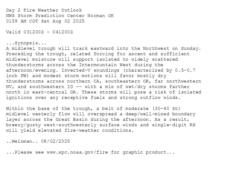
Day 2 Fire Weather Outlook
NWS Storm Prediction Center Norman OK
0159 AM CDT Sat Aug 02 2025
Valid 031200Z - 041200Z
...Synopsis...
A midlevel trough will track eastward into the Northwest on Sunday.
Preceding the trough, related forcing for ascent and sufficient
midlevel moisture will support isolated to widely scattered
thunderstorms across the Intermountain West during the
afternoon/evening. Inverted-V soundings (characterized by 0.5-0.7
inch PW) and modest storm motions will favor mostly dry
thunderstorms across northern CA, southeastern OR, far northwestern
NV, and southwestern ID -- with a mix of wet/dry storms farther
north in east-central OR. These storms will pose a risk of isolated
ignitions over any receptive fuels and strong outflow winds.
Within the base of the trough, a belt of moderate (30-40 kt)
midlevel westerly flow will overspread a deep/well-mixed boundary
layer across the Great Basin during the afternoon. As a result,
breezy/gusty west-southwesterly surface winds and single-digit RH
will yield elevated fire-weather conditions.
..Weinman.. 08/02/2025
...Please see www.spc.noaa.gov/fire for graphic product...
Day 2 Fire Weather Outlook Image
SPC Day 2 Fire Weather Outlook posted at Sat, 02 Aug 2025 07:02:13 +0000
🔥Synopsis🔥
Additional Details Here.
02.08.2025 07:40 — 👍 0 🔁 0 💬 0 📌 0
Day 1 Fire Weather Outlook
NWS Storm Prediction Center Norman OK
0158 AM CDT Sat Aug 02 2025
Valid 021200Z - 031200Z
...CRITICAL FIRE WEATHER AREA FOR PARTS OF SOUTHERN/SOUTHEASTERN
UTAH INTO NORTHWESTERN COLORADO...
...Synopsis...
Along the northern periphery of a large-scale ridge centered on the
Southwest/northern Mexico, a westerly midlevel jet streak will
overspread the southern/eastern Great Basin. In response, a weak
surface low will develop over eastern UT, resulting in a tightening
pressure gradient across the area.
...Southern/eastern UT into northwest CO...
Diurnal heating will result in a deeply mixed boundary layer across
the southern/eastern Great Basin, where widespread single-digit RH
is expected during the afternoon. Boundary-layer mixing into the
strengthening flow aloft, coupled with an enhanced pressure
gradient, will yield 20 mph west-southwesterly surface wind from
southern/eastern UT into northwest CO. The combination of breezy
surface winds and low RH will favor critical fire-weather
conditions, given receptive fuels across the region.
...Dry Thunderstorms - Intermountain West...
Diurnally driven high-based thunderstorms are expected across the
Intermountain West, aided by weak large-scale forcing for ascent
ahead of a deamplifying midlevel trough. Around 0.7 inch PW and a
deep/dry boundary layer will support mostly dry thunderstorms,
capable of lightning-induced ignitions over any receptive fuels.
..Weinman.. 08/02/2025
...Please see www.spc.noaa.gov/fire for graphic product...
Day 1 Fire Weather Outlook Image
SPC Day 1 Fire Weather Outlook posted at Sat, 02 Aug 2025 07:01:26 +0000
🔥CRITICAL FIRE WEATHER AREA FOR PARTS OF SOUTHERN/SOUTHEASTERN
UTAH INTO NORTHWESTERN COLORADO🔥
Additional Details Here.
02.08.2025 07:20 — 👍 0 🔁 0 💬 0 📌 0
Day 1 Fire Weather Outlook
NWS Storm Prediction Center Norman OK
1143 AM CDT Fri Aug 01 2025
Valid 011700Z - 021200Z
Hot, very dry (minimum RH values less than 10%), and breezy
(sustained surface winds of 15-20 mph) conditions are expected today
across much of the central/southern Great Basin and neighboring
portions of northwest Colorado and southwest Wyoming. As of 16Z,
observations across this area suggest locally elevated conditions
already ongoing with critical RH values present. Widespread elevated
conditions are expected from midday through this evening as winds
strengthen and RH values fall even further. The Elevated fire
weather area was expanded across this region based on the latest
high-resolution ensemble guidance.
Elevated fire weather conditions are also likely across wind-prone
portions of the Snake River Plain in Idaho, where several hours of
sustained winds of 15-20 mph (with greater gusts) and minimum RH
values near 15% are expected this afternoon/evening.
Locally critical fire weather conditions are most likely across
portions of southwest Utah, northwest Colorado into southwest
Wyoming, and also the Snake River Plain. Though, coverage is
forecast to be too spotty/brief to upgrade to Critical across these
areas.
The forecast for isolated dry thunderstorms over portions of the
northern Great Basin/Intermountain West remains on-track. Gusty and
erratic outflow winds will be possible nearby any thunderstorms.
Please see the previous discussion for more information on today's
fire weather forecast.
..Elliott.. 08/01/2025
.PREV DISCUSSION... /ISSUED 0155 AM CDT Fri Aug 01 2025/
...Synopsis...
Between a large-scale ridge centered on the Southwest/northern
Mexico and a broad/slow-moving midlevel trough crossing northern CA,
enhanced west-southwesterly midlevel flow will overspread the
southern Great Basin. Deep boundary-layer mixing into this enhanced
flow aloft will yield hot, dry, and breezy conditions during the
afternoon. Given receptive fuels, elevated fire-weather conditions
are expected across southern NV into southern UT.
Farther north, cool temperatures aloft/steep midlevel lapse rates
accompanying the trough will promote another day of isolated to
widely scattered high-based thunderstorms across the northern Great
Basin/Intermountain West. Inverted-V profiles and 0.6-0.7 inch PW
will favor mostly dry thunderstorms, with a risk of
lightning-induced ignitions over receptive fuels.
...Please see www.spc.noaa.gov/fire for graphic product...
Day 1 Fire Weather Outlook Image
SPC Day 1 Fire Weather Outlook posted at Fri, 01 Aug 2025 16:44:26 +0000
🔥 /ISSUED 0155 AM CDT Fri Aug 01 2025/
🔥
Additional Details Here.
01.08.2025 17:00 — 👍 0 🔁 0 💬 0 📌 0
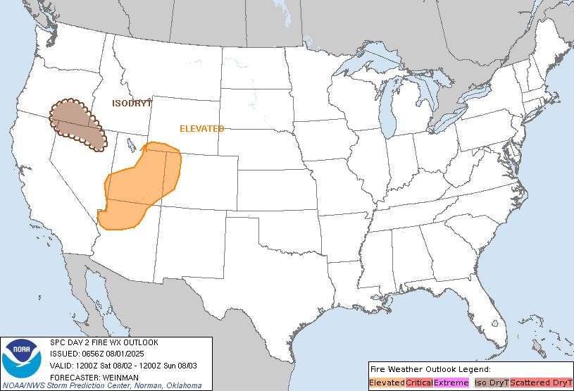
Day 2 Fire Weather Outlook
NWS Storm Prediction Center Norman OK
0156 AM CDT Fri Aug 01 2025
Valid 021200Z - 031200Z
...Synopsis...
A midlevel shortwave trough will deamplify as it moves slowly
eastward across the northern Great Basin during the day. Large-scale
forcing for ascent and steep low/midlevel lapse rates preceding this
feature will promote another day of isolated to widely scattered
high-based thunderstorms across the northern Great
Basin/Intermountain West. Around 0.5-0.7 inch PW and modest storm
motions will support mostly dry thunderstorms, posing a risk of
lightning-induced ignitions over receptive fuels.
Between the shortwave trough and a large-scale ridge over the
Southwest/northern Mexico, moderate midlevel westerly flow will
overspread a deeply mixed boundary layer over parts of the
Southwest/Great Basin into the central Rockies. Single-digit to
lower teens RH and breezy west-southwesterly surface winds will
yield elevated to locally critical fire-weather conditions across
parts of northern AZ, much of southern/central UT, and far western
CO during the afternoon.
..Weinman.. 08/01/2025
...Please see www.spc.noaa.gov/fire for graphic product...
Day 2 Fire Weather Outlook Image
SPC Day 2 Fire Weather Outlook posted at Fri, 01 Aug 2025 06:59:13 +0000
🔥Synopsis🔥
Additional Details Here.
01.08.2025 07:20 — 👍 0 🔁 0 💬 0 📌 0
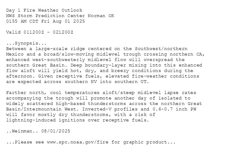
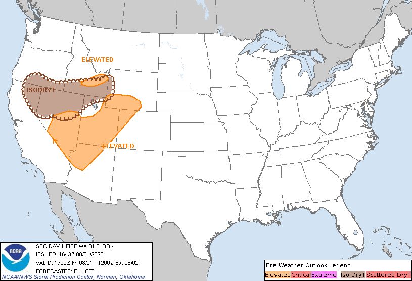
Day 1 Fire Weather Outlook
NWS Storm Prediction Center Norman OK
0155 AM CDT Fri Aug 01 2025
Valid 011200Z - 021200Z
...Synopsis...
Between a large-scale ridge centered on the Southwest/northern
Mexico and a broad/slow-moving midlevel trough crossing northern CA,
enhanced west-southwesterly midlevel flow will overspread the
southern Great Basin. Deep boundary-layer mixing into this enhanced
flow aloft will yield hot, dry, and breezy conditions during the
afternoon. Given receptive fuels, elevated fire-weather conditions
are expected across southern NV into southern UT.
Farther north, cool temperatures aloft/steep midlevel lapse rates
accompanying the trough will promote another day of isolated to
widely scattered high-based thunderstorms across the northern Great
Basin/Intermountain West. Inverted-V profiles and 0.6-0.7 inch PW
will favor mostly dry thunderstorms, with a risk of
lightning-induced ignitions over receptive fuels.
..Weinman.. 08/01/2025
...Please see www.spc.noaa.gov/fire for graphic product...
Day 1 Fire Weather Outlook Image
SPC Day 1 Fire Weather Outlook posted at Fri, 01 Aug 2025 06:58:26 +0000
🔥Synopsis🔥
Additional Details Here.
01.08.2025 07:20 — 👍 1 🔁 0 💬 0 📌 0
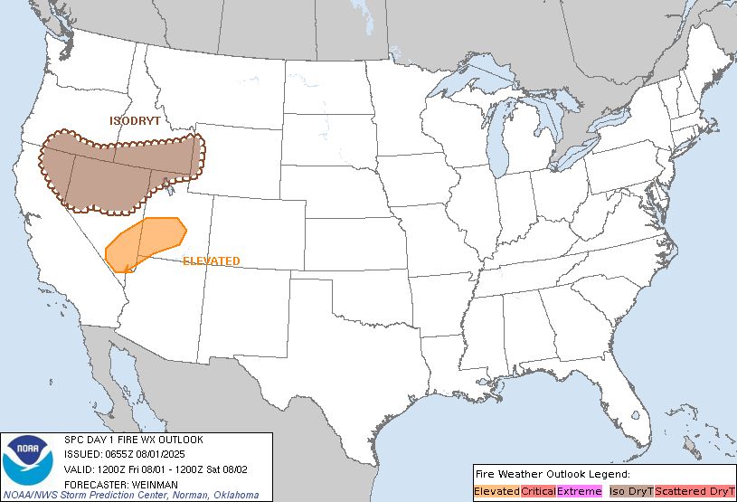
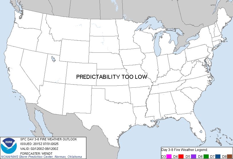
Day 3-8 Fire Weather Outlook
NWS Storm Prediction Center Norman OK
0315 PM CDT Thu Jul 31 2025
Valid 021200Z - 081200Z
...Great Basin...
Dry and windy conditions are generally expected each day through
mid/late next week. Deterministic/ensemble guidance shows greater
divergence toward the end of next week, but these conditions could
potentially linger even into next weekend. The main point of
uncertainty is the evolution of the upper trough in the West.
Cyclonic flow in the Northwest is the expected pattern, but how far
south/southeast the belt of stronger mid-level winds reaches is not
clear. Critical fire weather probabilities may need to be increased
in subsequent outlooks, but inter-model and run-to-run consistency
are too low at this point to confidently highlight a 70% area.
...Northwest...
Potential for thunderstorms will likely persist in the Northwest
through the weekend. This will primarily affect parts of Oregon.
With repeated days of convection plus the previous precipitation
that has fallen, concern for large fires should be trending
downward. Furthermore, storm motions will be slow until perhaps
Sunday where an approaching trough will move storms more quickly
northeastward. Overall, the threat for ignition of large fires is
too marginal for dry thunderstorm highlights. Another model trend
worth watching will be the track/timing of a forecast trough
mid/late next week. Winds would strengthen, but RH broadly falling
to critical levels is uncertain given the signal for clouds/cooler
temperatures. Some increase in fire activity from recent lightning
could occur if drier conditions were to occur.
..Wendt.. 07/31/2025
...Please see www.spc.noaa.gov/fire for graphic product...
Day 3-8 Fire Weather Outlook Image
SPC Day 3-8 Fire Weather Outlook posted at Thu, 31 Jul 2025 20:20:15 +0000
🔥Great Basin🔥
Additional Details Here.
31.07.2025 22:20 — 👍 1 🔁 0 💬 0 📌 0