* WHAT...Dangerous rip currents.
* WHERE...Walton, Bay, Gulf, and Franklin County Beaches.
* WHEN...Through late tonight.
* IMPACTS...Rip currents can sweep even the best swimmers away
from shore into deeper water.
Rip Current Statement issued August 13 at 1:16AM EDT until August 14 at 5:00AM EDT by NWS Tallahassee FL
Additional Details Here.
13.08.2025 05:30 — 👍 0 🔁 0 💬 0 📌 0
TAE extends time of Rip Currents Statement for Coastal Bay, Coastal Franklin, Coastal Gulf, South Walton [FL] till Aug 14, 5:00 AM EDT
at Wed, 13 Aug 2025 05:16:39 +0000 via IEMbot
Additional Details Here.
13.08.2025 05:26 — 👍 0 🔁 0 💬 0 📌 0
TAE issues Area Forecast Discussion (AFD) at Aug 12, 7:46 PM EDT ...New AVIATION... via IEMbot
Additional Details Here.
13.08.2025 00:06 — 👍 0 🔁 0 💬 0 📌 0
TALLAHASSEE Aug 12
Climate Report:
High: 89
Low: 76
Precip: 0.04"
Snow: 0.0"
at Tue, 12 Aug 2025 21:41:00 +0000 via IEMbot
Additional Details Here.
12.08.2025 21:46 — 👍 0 🔁 0 💬 0 📌 0
APALACHICOLA Aug 12
Climate Report:
High: 89
Low: 80
Precip: 0.01"
Snow: 0.0"
at Tue, 12 Aug 2025 21:41:00 +0000 via IEMbot
Additional Details Here.
12.08.2025 21:46 — 👍 0 🔁 0 💬 0 📌 0
PANAMA CITY NW Aug 12
Climate Report:
High: 90
Low: 75
Precip: 0.57"
Snow: 0.0"
at Tue, 12 Aug 2025 21:41:00 +0000 via IEMbot
Additional Details Here.
12.08.2025 21:46 — 👍 0 🔁 0 💬 0 📌 0
TAE issues A STRONG THUNDERSTORM WILL IMPACT NORTHEASTERN RANDOLPH AND NORTHWESTERN TERRELL COUNTIES THROUGH 500 PM EDT [wind: 40 MPH, hail: 0.00 IN]
at Tue, 12 Aug 2025 20:35:08 +0000 via IEMbot
Additional Details Here.
12.08.2025 20:46 — 👍 0 🔁 0 💬 0 📌 0
At 434 PM EDT, Doppler radar was tracking a strong thunderstorm near
Shellman, or 10 miles west of Dawson, moving north at 25 mph.
HAZARD...Wind gusts up to 40 mph.
SOURCE...Radar indicated.
IMPACT...Gusty winds could knock down tree limbs and blow around
unsecured objects.
Locations impacted include...
Shellman, Parrott, Chambliss, Graves, Brooksville, and Pachitla.
Special Weather Statement issued August 12 at 4:34PM EDT by NWS Tallahassee FL
Additional Details Here.
12.08.2025 20:45 — 👍 0 🔁 0 💬 0 📌 0
At 425 PM EDT, Doppler radar was tracking a strong thunderstorm 8
miles northeast of Leary, or 12 miles east of Morgan, moving north at
25 mph.
HAZARD...Wind gusts up to 40 mph.
SOURCE...Radar indicated.
IMPACT...Gusty winds could knock down tree limbs and blow around
unsecured objects.
Locations impacted include...
Dawson, Leesburg, Albany, Smithville, Walker, Sasser, Bronwood,
Lockett Crossing, Bridges Crossroad, Herod, Jordan Place, Ducker,
Yeomans, Clarks Mill, Dawson Municipal A/P, Byne Crossroads,
Scrutchins, Armena, Oakville, and Olivers Mill.
Special Weather Statement issued August 12 at 4:25PM EDT by NWS Tallahassee FL
Additional Details Here.
12.08.2025 20:30 — 👍 0 🔁 0 💬 0 📌 0
TAE issues A STRONG THUNDERSTORM WILL IMPACT WESTERN DOUGHERTYWESTERN LEENORTHEASTERN CALHOUN AND TERRELL COUNTIES IN SOUTHWESTERN GEORGIA THROUGH 515 PM EDT [wind: 40 MPH, hail: 0... at Tue, 12 Aug 2025 20:25:45 +0000 via IEMbot
Additional Details Here.
12.08.2025 20:26 — 👍 0 🔁 0 💬 0 📌 0
TAE issues Special Weather Statement [wind: 40 MPH, hail: 0.00 IN] for Baker, Calhoun, Dougherty [GA] till 4:30 PM EDT
at Tue, 12 Aug 2025 19:56:10 +0000 via IEMbot
Additional Details Here.
12.08.2025 20:06 — 👍 0 🔁 0 💬 0 📌 0
At 355 PM EDT, Doppler radar was tracking a strong thunderstorm near
Newton, moving north at 30 mph.
HAZARD...Wind gusts up to 40 mph.
SOURCE...Radar indicated.
IMPACT...Gusty winds could knock down tree limbs and blow around
unsecured objects.
Locations impacted include...
Newton, Leary, Red Store Crossroads, Bermuda, Elmodel Wma, Holt, and
Ducker.
Special Weather Statement issued August 12 at 3:55PM EDT by NWS Tallahassee FL
Additional Details Here.
12.08.2025 20:00 — 👍 0 🔁 0 💬 0 📌 0
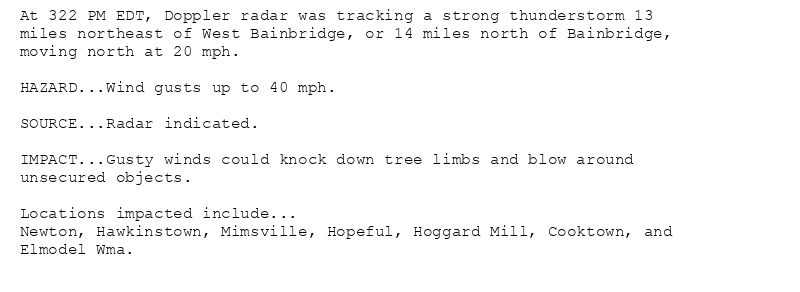
At 322 PM EDT, Doppler radar was tracking a strong thunderstorm 13
miles northeast of West Bainbridge, or 14 miles north of Bainbridge,
moving north at 20 mph.
HAZARD...Wind gusts up to 40 mph.
SOURCE...Radar indicated.
IMPACT...Gusty winds could knock down tree limbs and blow around
unsecured objects.
Locations impacted include...
Newton, Hawkinstown, Mimsville, Hopeful, Hoggard Mill, Cooktown, and
Elmodel Wma.
Special Weather Statement issued August 12 at 3:23PM EDT by NWS Tallahassee FL
Additional Details Here.
12.08.2025 19:30 — 👍 0 🔁 0 💬 0 📌 0
TAE issues A STRONG THUNDERSTORM WILL IMPACT EASTERN MILLERSOUTHWESTERN MITCHELL AND SOUTHWESTERN BAKER COUNTIES THROUGH 400 PM EDT [wind: 40 MPH, hail: 0.00 IN]
at Tue, 12 Aug 2025 19:23:17 +0000 via IEMbot
Additional Details Here.
12.08.2025 19:26 — 👍 0 🔁 0 💬 0 📌 0
TAE issues Area Forecast Discussion (AFD) at Aug 12, 2:51 PM EDT ...New NEAR TERM, SHORT TERM, LONG TERM, MARINE, FIRE WEATHER, HYDROLOGY... via IEMbot
Additional Details Here.
12.08.2025 19:06 — 👍 0 🔁 0 💬 0 📌 0
TAE issues A STRONG THUNDERSTORM WILL IMPACT NORTHEASTERN DALE COUNTY THROUGH 200 PM CDT [wind: 40 MPH, hail: 0.00 IN]
at Tue, 12 Aug 2025 18:36:52 +0000 via IEMbot
Additional Details Here.
12.08.2025 18:46 — 👍 0 🔁 0 💬 0 📌 0
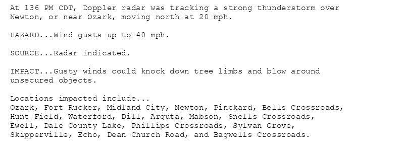
At 136 PM CDT, Doppler radar was tracking a strong thunderstorm over
Newton, or near Ozark, moving north at 20 mph.
HAZARD...Wind gusts up to 40 mph.
SOURCE...Radar indicated.
IMPACT...Gusty winds could knock down tree limbs and blow around
unsecured objects.
Locations impacted include...
Ozark, Fort Rucker, Midland City, Newton, Pinckard, Bells Crossroads,
Hunt Field, Waterford, Dill, Arguta, Mabson, Snells Crossroads,
Ewell, Dale County Lake, Phillips Crossroads, Sylvan Grove,
Skipperville, Echo, Dean Church Road, and Bagwells Crossroads.
Special Weather Statement issued August 12 at 1:36PM CDT by NWS Tallahassee FL
Additional Details Here.
12.08.2025 18:45 — 👍 0 🔁 0 💬 0 📌 0
TAE issues Area Forecast Discussion (AFD) at Aug 12, 1:52 PM EDT ...New AVIATION... via IEMbot
Additional Details Here.
12.08.2025 18:06 — 👍 0 🔁 0 💬 0 📌 0
TAE issues Marine Warning [waterspout: POSSIBLE, wind: >34 KTS, hail: 0.00 IN] for Apalachee Bay or Coastal Waters From Keaton Beach to Ochlockonee River Fl out to 20 Nm, Coasta... at Tue, 12 Aug 2025 15:12:46 +0000 via IEMbot
Additional Details Here.
12.08.2025 15:26 — 👍 0 🔁 0 💬 0 📌 0

SMWTAE
The National Weather Service in Tallahassee has issued a
* Special Marine Warning for...
Apalachee Bay or Coastal Waters From Keaton Beach to Ochlockonee
River Fl out to 20 Nm...
Coastal Waters From Ochlockonee River to Apalachicola FL out to 20
Nm...
Coastal waters from Suwannee River to Keaton Beach out 20 NM...
Waters from Suwannee River to Apalachicola FL from 20 to 60 NM...
* Until 1215 PM EDT.
* At 1112 AM EDT, a severe thunderstorm capable of producing
waterspouts was located 10 nm north of Buckeye Reef, moving north
at 20 knots.
HAZARD...Waterspouts and wind gusts 34 knots or greater.
SOURCE...Radar indicated.
IMPACT...Waterspouts can quickly form and capsize boats...damage
vessels...and create suddenly higher waves. Make sure all
on board are in a secure location and wearing life
jackets. Expect wind gusts in excess of 34
knots...suddenly higher waves...frequent lightning...and
heavy downpours. Make sure all on board are wearing life
jackets.
* The severe thunderstorm will remain over mainly open waters.
🚨 Special Marine Warning issued August 12 at 11:12AM EDT until August 12 at 12:15PM EDT by NWS Tallahassee FL 🚨
Additional Details Here.
12.08.2025 15:15 — 👍 1 🔁 0 💬 0 📌 0
TAE issues Area Forecast Discussion (AFD) at Aug 12, 9:53 AM EDT ...New UPDATE, MARINE... via IEMbot
Additional Details Here.
12.08.2025 14:06 — 👍 0 🔁 0 💬 0 📌 0
TAE issues Marine Warning [wind: >34 KTS, hail: 0.00 IN] for Coastal Waters from Mexico Beach to Apalachicola out 20 NM, Coastal waters from Okaloosa-Walton County Line to Mexic... at Tue, 12 Aug 2025 11:12:33 +0000 via IEMbot
Additional Details Here.
12.08.2025 11:26 — 👍 0 🔁 0 💬 0 📌 0
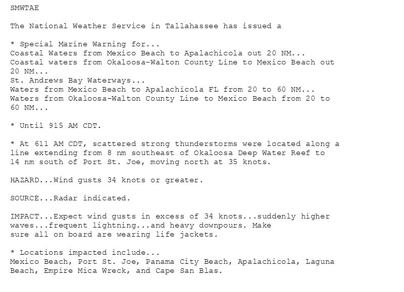
SMWTAE
The National Weather Service in Tallahassee has issued a
* Special Marine Warning for...
Coastal Waters from Mexico Beach to Apalachicola out 20 NM...
Coastal waters from Okaloosa-Walton County Line to Mexico Beach out
20 NM...
St. Andrews Bay Waterways...
Waters from Mexico Beach to Apalachicola FL from 20 to 60 NM...
Waters from Okaloosa-Walton County Line to Mexico Beach from 20 to
60 NM...
* Until 915 AM CDT.
* At 611 AM CDT, scattered strong thunderstorms were located along a
line extending from 8 nm southeast of Okaloosa Deep Water Reef to
14 nm south of Port St. Joe, moving north at 35 knots.
HAZARD...Wind gusts 34 knots or greater.
SOURCE...Radar indicated.
IMPACT...Expect wind gusts in excess of 34 knots...suddenly higher
waves...frequent lightning...and heavy downpours. Make
sure all on board are wearing life jackets.
* Locations impacted include...
Mexico Beach, Port St. Joe, Panama City Beach, Apalachicola, Laguna
Beach, Empire Mica Wreck, and Cape San Blas.
🚨 Special Marine Warning issued August 12 at 6:12AM CDT until August 12 at 9:15AM CDT by NWS Tallahassee FL 🚨
Additional Details Here.
12.08.2025 11:15 — 👍 0 🔁 0 💬 0 📌 0
TAE issues A STRONG THUNDERSTORM WILL IMPACT NORTHWESTERN BAYEAST CENTRAL WALTONSOUTHWESTERN HOLMES AND WESTERN WASHINGTON COUNTIES THROUGH 600 AM CDT [wind: 40 MPH, hail: 0.00 IN]... at Tue, 12 Aug 2025 10:33:25 +0000 via IEMbot
Additional Details Here.
12.08.2025 10:46 — 👍 0 🔁 0 💬 0 📌 0
TAE issues Area Forecast Discussion (AFD) at Aug 12, 6:44 AM EDT ...New AVIATION... via IEMbot
Additional Details Here.
12.08.2025 10:46 — 👍 0 🔁 0 💬 0 📌 0
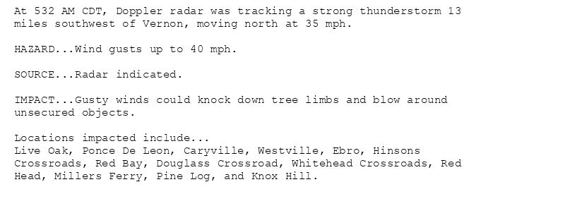
At 532 AM CDT, Doppler radar was tracking a strong thunderstorm 13
miles southwest of Vernon, moving north at 35 mph.
HAZARD...Wind gusts up to 40 mph.
SOURCE...Radar indicated.
IMPACT...Gusty winds could knock down tree limbs and blow around
unsecured objects.
Locations impacted include...
Live Oak, Ponce De Leon, Caryville, Westville, Ebro, Hinsons
Crossroads, Red Bay, Douglass Crossroad, Whitehead Crossroads, Red
Head, Millers Ferry, Pine Log, and Knox Hill.
Special Weather Statement issued August 12 at 5:33AM CDT by NWS Tallahassee FL
Additional Details Here.
12.08.2025 10:45 — 👍 0 🔁 0 💬 0 📌 0
Weather Prediction Center issues Mesoscale Precipitation Discussion #917 concerning HEAVY RAINFALL...FLASH FLOODING POSSIBLE
at Tue, 12 Aug 2025 09:58:42 +0000 via IEMbot
Additional Details Here.
12.08.2025 10:06 — 👍 0 🔁 0 💬 0 📌 0
2 WNW Blue Mountain Bea [Walton Co, FL] Mesonet reports Tstm Wnd Gst of M40 MPH at 3:44 AM EDT -- Courtesy of Weatherstem at Ed Walline Beach Access.
at Tue, 12 Aug 2025 08:12:11 +0000 via IEMbot
Additional Details Here.
12.08.2025 08:26 — 👍 0 🔁 0 💬 0 📌 0
TAE issues Area Forecast Discussion (AFD) at Aug 12, 3:18 AM EDT ...New NEAR TERM, SHORT TERM, LONG TERM, MARINE, FIRE WEATHER, HYDROLOGY... via IEMbot
Additional Details Here.
12.08.2025 07:26 — 👍 0 🔁 0 💬 0 📌 0
PANAMA CITY NW Aug 11
Climate Report:
High: 90
Low: 76
Precip: 0.54"
Snow: 0.0"
at Tue, 12 Aug 2025 06:36:01 +0000 via IEMbot
Additional Details Here.
12.08.2025 06:46 — 👍 0 🔁 0 💬 0 📌 0