YouTube video by Postholer
Pacific Crest Trail Viewshed
Viewshed of the entire #PacificCrestTrail.
A viewshed is the unobstructed area you can see standing at a given location. A vista, you probably have expansive views. The bottom of a canyon, maybe not so much.
www.youtube.com/watch?v=tmY2...
There's one for the #JohnMuirTrail, too! #ParkChat
23.04.2025 17:59 —
👍 11
🔁 3
💬 0
📌 1
Note, this data is available for every trail found on the Postholer.com web site:
www.postholer.com/trail-maps
17.04.2025 22:53 —
👍 2
🔁 1
💬 1
📌 0


How cold does it get?
Probably the most frequent question asked by hikers. Fortunately, it's easy to answer empirically using climate data.
Entire year graph and July min temp overlay for visible trail.
www.postholer.com/map/Pacific-...
#PacificCrestTrail #JohnMuirTrail #ParkChat
17.04.2025 22:51 —
👍 10
🔁 1
💬 1
📌 0
It looks like each hex has the min value in each hex polygon, then the hex and Z values are all exaggerated by some postive N value.
Either way, it's damn cool!
16.04.2025 23:32 —
👍 0
🔁 0
💬 0
📌 0
I'll take the 18th! #ParkChat
15.04.2025 00:17 —
👍 2
🔁 0
💬 1
📌 0
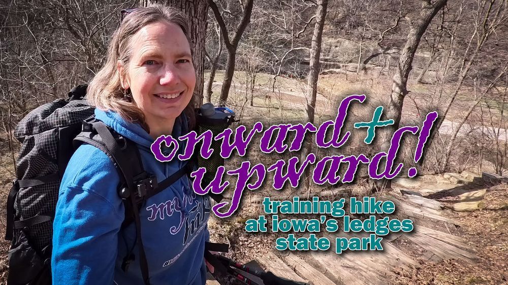
the steps go up ⬆️ the steps go down ⬇️
watch @ tinyurl.com/mythic-ep18
in this video, i hit some good midwest hills to prep for my upcoming pacific crest trail hike!
#pct #pcthiker #pacificcresttrail #hiking #training
13.04.2025 15:03 —
👍 2
🔁 1
💬 0
📌 0

Stellar camping spot 5.1 miles south of Scissors Crossing.
07.04.2025 20:57 —
👍 10
🔁 1
💬 1
📌 0

Um, ok. ;) Give me a hard date when we get closer. And some hints on the 'proper' way of executing this honorable task.
05.04.2025 21:43 —
👍 1
🔁 0
💬 1
📌 0

Just a heads up. If you're looking to hike in NorCal between Castella and Seiad Valley (this includes Etna), snow conditions are ~200% of normal. Often, you can get in there late May/early June. Check before you go!
www.postholer.com/snow/Pacific...
04.04.2025 19:54 —
👍 3
🔁 0
💬 0
📌 0
A9) @pacificcresttrail.bsky.social present and accounted for, although a bit late.
Note, my account does not represent the Pacific Crest Trail Association. I've been a trail advocate since 1999 and providing web content for the PCT since 2003. You may know me as Postholer.
#ParkChat
03.04.2025 04:03 —
👍 5
🔁 0
💬 0
📌 0
It's all in your head. Don't lock yourself in the "what-if prison."
27.03.2025 05:04 —
👍 1
🔁 0
💬 0
📌 0
Continuous days of rain, never getting a chance to dry out your gear. Not fun.
27.03.2025 05:01 —
👍 2
🔁 0
💬 1
📌 0
Losing a shoe. Having a deer walk off with a salty and tasty trail runner or two. I'm freaky about keeping my shoes tied down or in my tent if not cowboy camping.
27.03.2025 05:00 —
👍 1
🔁 0
💬 1
📌 0
Hike 20-30 miles a day. A cougar could piss on your forehead and you wouldn't wake up.
27.03.2025 04:57 —
👍 1
🔁 0
💬 0
📌 0
#PCT in Washington, 7 trail miles south of Cispus Pass. 2:00AM or so, was awoken by a loud, thunderous noise my groggy head couldn't wrap around. Dirt, duff flying all over me.
Something spooked a herd of about 70 elk. Nearly, got trampled. Dozens of bear encounters in life, but this!
#ParkChat
27.03.2025 04:55 —
👍 3
🔁 0
💬 1
📌 0

Spring they said.
www.postholer.com/map/Pacific-...
#PacificCrestTrail
27.03.2025 04:48 —
👍 7
🔁 0
💬 0
📌 0

Pacific Crest Trail - 2013
Pacific Crest Trail 2013 - Postholer - Thu, Aug 8th, 2013 - The Hood
Little Crater Lake, Oregon. Easily worth the flat, 5 minute walk off-trail.
www.postholer.com/journal/Paci...
#ParkChat #PacificCrestTrail
22.03.2025 22:46 —
👍 12
🔁 1
💬 0
📌 0

Wind turbines, the good, the bad and the ugly.
postholer.com/map/Pacific-...
Zoomed out you get clusters of turbines, zoom in for individual turbines. Mouse over or click turbine for more info.
We've added wind turbines to our data on Postholer Interactive Maps.
14.11.2024 22:42 —
👍 4
🔁 2
💬 2
📌 0


Here are 2 photos of post lightning strikes along the #PacificCrestTrail.
Image 1, from 2013 just north of Separation Creek in 3 Sisters Wilderness, OR. Barked stripped and duff/root structure still smoldering.
Image 2, from 2003 just north of Fire Creek Pass, WA, moments after strike.
#ParkChat
21.02.2025 18:05 —
👍 12
🔁 2
💬 0
📌 0

Next up:
www.postholer.com/map/Pacific-...
13.02.2025 18:33 —
👍 3
🔁 0
💬 0
📌 0


Ladies & gentleman, it snowed.
The sierra got a significant bump over the last few days, going from 60% to 90% trail snow, SWE.
www.postholer.com/snow/Pacific...
Still 2 months to go till peak sierra snow season, so stay tuned!
#PacificCrestTrail #JohnMuirTrail
07.02.2025 18:31 —
👍 14
🔁 2
💬 1
📌 0

Rainfall (not SWE) across the sierra is continuing to look very dry, ranging from 30%-70% of normal, around 50% overall.
Plenty of winter remains to turn that around. Let's wait and see how it plays out. Good for hikers, maybe dry water sources in the south.
www.postholer.com/map/Pacific-...
30.01.2025 18:47 —
👍 10
🔁 2
💬 0
📌 0
As of Jan 22 the first 500 miles is between 2% and 20% of normal.
Some areas are 5-10 inches below normal! That's huge for socal.
22.01.2025 18:53 —
👍 1
🔁 0
💬 0
📌 0

Here's the latest 'trail snow' conditions in the sierra. The very, very dry stretch continues.
Trail snow between Crabtree Mdw & Tuolumne Mdw is at 66% of normal for this time of year.
Let's see what the rest of winter holds:
www.postholer.com/snow/Pacific...
#PacificCrestTrail #JohnMuirTrail
22.01.2025 18:45 —
👍 10
🔁 1
💬 0
📌 0

Looking at the first 100 miles.
If you start in March, climate says you're looking at up to 4 inches of rain and min temps around 30.
The chart below says nothing of wind.
I'm not trying to rain on your hike. ;)
www.postholer.com/map/Pacific-...
10.01.2025 19:25 —
👍 0
🔁 0
💬 0
📌 0

How dry is the southern California #PCT?
The first 500 miles of trail is currently 5% to 25% of normal. This translates roughly 5-10 inches of rain so far, with mountain areas at the 25% end.
See how this water year compares to climate, anywhere along the trail.
www.postholer.com/map/Pacific-...
09.01.2025 17:18 —
👍 6
🔁 1
💬 1
📌 1


