(PDF) Professor Dieter Mueller-Dombois (1925-2022), obituary
PDF | On Dec 15, 2022, Hans Juergen Boehmer published Professor Dieter Mueller-Dombois (1925-2022), obituary | Find, read and cite all the research you need on ResearchGate
Dieter #Mueller-Dombois would have turned 100 years old these days. He died in 2022, one week before his 97th birthday. His archive on the #vegetation of the tropical #Pacific islands consists of countless notes, documents and slides. Context: www.researchgate.net/publication/...
10.08.2025 12:58 — 👍 2 🔁 1 💬 0 📌 1

A box with dozens of unpublished works for the Smithsonian Institute from Dieter Mueller-Dombois´ research in Sri Lanka (former Ceylon) 1967-69. There, he studied effects of elephants on the woody vegetation in a major wild elephant refuge in the island´s southeastern dry zone.
The amount and quality of legacy data in the #Mueller-Dombois archive is overwhelming. This is a box with unpublished works for the #Smithsonian Institute from the period in #SriLanka (former Ceylon) 1967-69. Context: esajournals.onlinelibrary.wiley.com/doi/10.2307/...
10.08.2025 12:36 — 👍 2 🔁 0 💬 0 📌 0

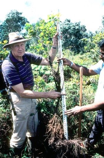
Early 1980s: Dieter Mueller-Dombois and Mallikarjuna Aradhya pulling a Metrosideros polymorpha sapling out of organic peat somewhere in Hawai´i´s rainforest. Courtesy of Annette Mueller-Dombois.
Dieter´s interdisciplinary research into the causes of large-scale #forest #dieback in forests on the islands of #Hawai´i throughout the 1970s and 80s had a global impact and can be seen as exemplary for modern multi-causal forest #decline #research. Context: muse.jhu.edu/pub/5/articl...
05.08.2025 12:20 — 👍 2 🔁 0 💬 0 📌 1

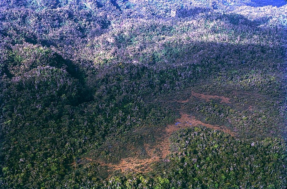
March 1972: Hawai´i, Island of Kaua´i, Alaka´i Swamp area. Aerial photograph of forest dieback. Dying and dead Metrosideros trees stand out in grey against the few remaining healthy, green trees. Note on slide: `Terminal dieback, Alaka´i, March 1972`. Photo by Dieter Mueller-Dombois. The Alakaʻi Swamp (Alakaʻi Wilderness Preserve) is a montane rainforest on the island of Kaua´i in Hawai´i, located on a plateau near Mount Waiʻaleʻale, one of the wettest places on Earth. Although it is called a swamp, it is actually a rainforest.
Prof. Mueller-Dombois has been studying #forest #dieback in the Hawaiian #Islands since the late 1960s. This aerial photograph was taken during a reconnaisance flight over the dieback area in #Alaka´i Swamp, Kaua´i, in March 1972. Photo by D. M.-D.. Context: www.google.de/books/editio...
02.08.2025 07:53 — 👍 1 🔁 0 💬 0 📌 1

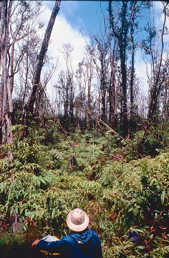
August 1976, Island of Hawaii (Big Island), Saddle Road area: Professor Dieter Mueller-Dombois, Botany Department, University of Hawaii at Manoa, takes notes on the decline (dieback) of native ohia lehua trees (Metrosideros polymorpha). Photograph by James D. Jacobi.
Let's start with our header. August 1976, Hawaii, Big Island, Saddle Road area: Prof. Dieter Mueller-Dombois, University of Hawaii at Manoa, takes notes on the dieback of native Ohia trees (Metrosideros polymorpha). Photo by James D. Jacobi. Context: scholarspace.manoa.hawaii.edu/server/api/c...
01.08.2025 12:06 — 👍 1 🔁 0 💬 0 📌 1
IUFRO Task Force 57 was established in 2025 to rescue old forest data from boreal🌲, temperate🌳, subtropical🌵 and tropical🌴 regions. We will focus on numerical data, but other ‘data’ such as old photos, maps, and "lost" reports are also important. We´ll present an interesting selection here...
30.07.2025 13:29 — 👍 1 🔁 0 💬 0 📌 1
Sustainability - Sustainable Living - Travel - Conservation - Green Energy - Wildlife Protection - Conservation - Habitat preservation - Protection of Oceans, Forests and Communities
environmental historian | historical ecologist | Institute of Botany, Czech Academy of Sciences | Faculty of Social Sciences, Masaryk University #envhist #historicalecology
Improving access to FORest GENetic resources Information and services for end-USers - This is an HorizonEU project (no 862221) 🇪🇺
Historical Geography #planthumanities PhD student at Royal Holloway & RBG Kew researching the cultural history of arboretums. Book author, former magazine editor, gardener, cat servant
Director of Collaborative Research, Atlantic Forestry Centre
Canadian Forest Service / Natural Resources Canada
Internet Archive is a non-profit research library preserving web pages, books, movies & audio for public access. Explore web history via the Wayback Machine.
Place-based historian based in Philadelphia; professor at Penn; author of “Elderflora: A Modern History of Ancient Trees”
News from the European Society for Environmental History. http://www.eseh.org
Next conference in Uppsala, 18–22 August 2025.
Also check out https://bsky.app/profile/esehnextgate.bsky.social
The Network in Canadian History & Environment.
NiCHE is a confederation of researchers & educators who work at the intersection of nature & history.
niche-canada.org
Environmental historian. Professor Univ of Stavanger. Co-director Greenhouse Center for #envhum. Co-editor Environmental Humanities journal. Extinction; animal history.
New book: The Medieval Pig (Boydell 2024) https://boydellandbrewer.com/9781837651689/th
The International Consortium of Environmental History Organizations (ICEHO) fosters international communication among environmental history organizations and #EnvHist scholars.
Website: https://iceho.org
International center for environmental humanities research in Munich, Germany.
Website: https://www.carsoncenter.uni-muenchen.de
Portal: https://www.environmentandsociety.org/
Seeing the Woods: https://seeingthewoods.org/
Springs: https://springs-rcc.org/
Environmental historian working on wildlife conservation, extinction & political ecology of forests. University of Oulu, Finland, since June 2025.
Former @MaastrichtUni & former RCC fellow
Environmental historian, author of Profit: An Environmental History (2023) and Inherit the Holy Mountain: Religion and the Rise of American Environmentalism (2015). https://www.markstoll.net/ Professor at @texastechuniv.bsky.social
#CdnHist and #EnvHist Professor and Vice-Provost Academic
@TorontoMet. Executive member of Network in Canadian History & Environment. He/Him
cultural & environmental historian. #bchist and #cdnhist and #envhist. landscape, mobilities, public pasts, fordism, tourism, parks, infrastructure, rowdies, fruit stands, seasonality, 1970+, etc.
Sharing more than 150 years of history from the U.S. Fish and Wildlife Service Museum and Archives at the National Conservation Training Center in Shepherdstown, WV. Focusing on American conservation history, wildlife history, and environmental history.
Human ecologist by training, environmental and energy historian by doing @univie.ac.at
URL: https://robertgross.org/
Environmental historian| Pomona College|books: Burn Scars (2024)/Natural Consequences (2022)/West Side Rising (2021) | lucky grandpa
Science journalist, Field and Lab Newsletter https://joespring.substack.com/ / Formerly Smithsonian Magazine, Outside Magazine, NOAA, USFWS, National Park Service / https://joespring.com/


