FINALLY feeling like fall in Phoenix 🌵🍂
First time in the 70s since May 😎
Windows open, AC off 👍

@jorgetweather.bsky.social
Emmy-winning ABC15 Meteorologist & 'Impact Earth' Climate Reporter | AMS CBM | NWA Television Seal | NAHJ | Texas A&M ‘09 | ΩΔΦ | Previous: KOB, KVIA
FINALLY feeling like fall in Phoenix 🌵🍂
First time in the 70s since May 😎
Windows open, AC off 👍

Best week of weather we’ve had in MONTHS.
Mid 80s. Low humidity. Cool nights. Sunshine every day.

Phoenix just had a wetter October than the entire monsoon season🤯
3.26" in October vs. 2.76" all monsoon.
This is now the 3rd-wettest October on record in the Valley.

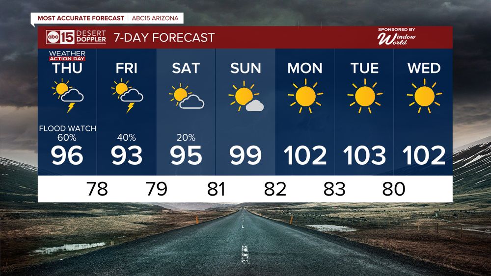
🚨 FLOOD WATCH COVERS MOST OF ARIZONA 🚨
Flooding risk ramps up as Priscilla and Raymond's moisture moves in
✅ Flood Watch through Saturday evening for most of the state
✅ Another Flood Watch begins Saturday afternoon for southeastern AZ (Tucson, Safford) and lasts through Monday.

🚨 WEATHER ACTION DAYS FRIDAY & SATURDAY 🚨
Two tropical systems + Pacific low = flooding risk across Arizona.
Temps drop into the 80s by Saturday in Phoenix but storms stick around.

TRACKING THE TROPICS 🌀
Priscilla + a new tropical threat (Raymond) = moisture headed our way.
💧 Reminder: We’re already under Weather Action Days Thu–Sat as we track rain chances and flooding concerns.

⚠️🌧️ MODERATE FLOOD RISK FRIDAY 🌧️⚠️
The Weather Prediction Center puts much of AZ, including Phoenix, Prescott, Sedona & Flagstaff, under a Moderate Risk of flash flooding.
👉 Numerous flooding events are possible
👉 Streams may overflow
👉 Larger rivers could also be impacted

🌧️ BIG WEATHER SHAKE-UP AHEAD🌧️
Remnants of Priscilla + a Pacific storm = several days of rain in Arizona, including Phoenix.
⚠️ WEATHER ACTION DAYS: Thu–Sat
👉 Scattered storms
👉 Flooding risk
👉 Temps dropping into the 80s by the weekend!

🌡️ From 🔥 to 🌧️➡️ Big weather swing ahead!
100° today in the Valley, but rain chances jump starting tomorrow with the BEST shot at storms Friday & Saturday thanks to the remnants of Priscilla 🌩️🌧️

ALL EYES ON HURRICANE PRISCILLA 🚨
Moisture from this storm + a Pacific system = an October soaking for Arizona🌧️
🌧️ Rain chances ramp up Fri-Sat
🌊 Flooding possible in washes/low spots

🔥 From 100° heat to a weekend cooldown with storm chances🌧️
Moisture from Hurricane Priscilla moves in late week, bringing a better shot at rain Friday and Saturday🌩️

🌧️ Big changes ahead for Arizona 🌵
Moisture from Hurricane Priscilla’s remnants could surge into the Desert Southwest late this week, boosting rain chances and humidity 🌀
Some spots could see heavier pockets of rain by the weekend ⛈️
Still early, but worth watching 👀

After a beautiful fall weekend, the heat is back! 🔥
We’re hitting 💯 again by Wednesday before storm chances return late week.
Remnants of Hurricane Priscilla could send moisture our way, boosting rain chances Friday into the weekend 🌀
This one could get interesting 👀

PHX forecast 🔥➡️😎
From 101° today to a weekend cooldown in the low 90s!
Open the windows, enjoy the mornings in the 60s, and give the A/C a little break 🍂

🔥 Arizona’s fall forecast: still flexing summer vibes.
Today + tomorrow = TRIPLE DIGIT HEAT (normal is 95°)
Then temps crash into the low 90s this weekend!

🔥 From near record heat to storms and a weekend cooldown 🌩️⬇️
Phoenix hits 107° today, then storms arrive late Thursday with highs crashing into the 80s.
Monsoon 2025 ends Tuesday… and we’re still over an inch below normal rainfall🌵💧

From triple digits to storm chances 🌩️
➡️ Big swings ahead in the Valley! 106° heat midweek, then a sharp cooldown into the 90s with rain chances returning.

Phoenix’s fall forecast:
🌵 First day of fall → 99° with storms 🌦️
🌡️ Midweek heat → 107° 🔥
⛈️ Weekend cooldown → 90s with storm chances

🌤️ Fall officially begins Monday… but Mother Nature hasn't gotten the memo.
The “normal” high this time of year in Phoenix is 99°, and we’ll be above it more often than not.
Fall in Arizona: still summer… with a side of storms🌵⚡

☀️ Fall’s about to show up… but the heat isn’t ready to leave 🌡️
⛈️ Today brings a shot at storms (30%) and a break from the triple digits at 97°
🔥 Then we bounce right back to 100°+ through next week...peaking at 104° Tue & Wed 😳
Arizona fall = still summer 😅

🌧️⚡ We woke up to spotty showers and thunderstorms across the Valley… and it’s just the beginning.
Monsoon moisture is surging back in, with our best storm chances Thursday night into Friday morning.
After that? Sunshine and a quick jump back to 105° by midweek🥵

🌵 From hazy to blazing!
Monsoon moisture could cool us into the 90s Thursday and Friday…but by early next week?
FALL starts with 105° 🥵🍂

The 100s are sticking around… but relief is on the way later this week🌡️
Tue: 104° ☀️
Wed: 102° & partly cloudy 🌤️
Thu: 98° with a slight chance of rain 🌦️
Fri: 97° ... a little more cooling and a better chance for rain ⛈️
Weekend highs bounce back into the low 100s 🌞

High pressure is back and temps are climbing...hitting 105° by Tuesday 🥵
⛈️ Storm chances sneak back in mid-to-late week (thanks to some tropical moisture 👀)
🌡️ A slight break into the 90s by Friday before the heat bounces back.

🌬️ Breezy finish to the week at 100° today…
🌞 A taste of the 90s this weekend…
🔥 Then back to the triple digits next week!
Arizona fall in a nutshell🍂☀️

Phoenix ‘cool down’ incoming 👀
Highs dip into the upper 90s Saturday before triple digits return next week.
Enjoy it while it lasts🥵🌵

🔥 From 107° to the 90s in just a few days? The Valley is finally catching a late-summer cooldown!
🌬️ Breezy midweek
🌡️ Highs dip below 100° Saturday
☀️ Back near average early next week

🔥 Summer’s not giving up just yet!
Another 106° today before temps finally dip closer to double digits by the weekend.

☀️ Summer isn’t done with us yet, but cooler changes are coming to Phoenix!
🔥 104–105° through midweek
💨 Breezy Wednesday & Thursday
🌡️ Relief arrives late week with highs in the 90s + cooler mornings in the 70s (some 60s in rural spots!)
⚠️ FLOOD WATCH today with storms likely across the Valley.
Temps stay below 100 through Saturday 🌩️☀️