Cover page of the Hunga Atmospheric Impacts report, showing satellite images of the eruption plume.
Four years since #Hunga #volcano (Tonga) unleashed one of the most explosive volcanic #eruptions ever observed, providing a new paradigm of submarine volcanism. Read all about the atmospheric impacts of the 2022 Hunga eruption in a new open-access report: juser.fz-juelich.de/record/1049154
15.01.2026 22:29 — 👍 8 🔁 1 💬 0 📌 0
The final ~25 seconds of footage from the V3 webcam at #Kilauea #volcano, during Episode 38 of lava fountain activity. Courtesy of USGS.
USGS feed: www.youtube.com/watch?v=Bqmp...
06.12.2025 22:55 — 👍 45 🔁 16 💬 1 📌 4

As of November 26, the SO₂ emitted by #HayliGubbi on Nov 23 has been sheared out into a near-continuous plume extending from East Africa to the central Pacific. SO₂ data from #NOAA-20 OMPS.
26.11.2025 19:57 — 👍 4 🔁 0 💬 0 📌 0
Pre- and post-eruption visible imagery of #HayliGubbi from #Sentinel-2, showing tephra deposits and 2 new craters. The latter could be eruption vents and/or formed by post-eruptive subsidence. Looks like the pre-existing crater was enlarged by the eruption. @esa.int
25.11.2025 15:44 — 👍 17 🔁 4 💬 1 📌 0
And the #HayliGubbi ash deposit has already been sampled to the north of the volcano by @derekkeir.bsky.social. Could provide some insight into the eruption process.
bsky.app/profile/dere...
25.11.2025 02:46 — 👍 5 🔁 0 💬 1 📌 0
Some nice commentary on the #HayliGubbi #eruption here from @julietbiggs.bsky.social and others. As discussed, it's unlikely that this is actually the first eruption of the volcano in 12,000 years. The Afar region is very active but also remote and understudied.
bsky.app/profile/scia...
24.11.2025 23:37 — 👍 6 🔁 1 💬 2 📌 0
Thanks Tim. @planet.com imagery from Nov 24 show some subsidence in the southern half of the Erta Ale caldera after the #HayliGubbi eruption (plus widespread ash deposits).
24.11.2025 17:29 — 👍 16 🔁 7 💬 1 📌 0

Satellite image of sulfur dioxide (SO₂) column amounts in the atmosphere on November 24, after an eruption of Hayli Gubbi volcano in Ethiopia on November 23. SO₂ columns are depicted using a rainbow color scale ranging from white (low or zero SO₂) to red (high SO₂).
New #TROPOMI data on Nov 24 show higher total SO₂ emissions from #HayliGubbi (~0.2 Tg SO₂). Measurements on Nov 23 were likely impacted by the dense volcanic ash plume. Most of the SO₂ is spreading rapidly east in the subtropical jet stream, over the Arabian Sea towards NW India and Pakistan.
24.11.2025 13:53 — 👍 25 🔁 6 💬 1 📌 0

Sentinel-5P #TROPOMI measurements at ~11:00 UTC show most of the SO₂ emissions from #HayliGubbi spreading east in the upper troposphere. Plume contains ~44 kilotons of SO₂ (~0.04 Tg).
23.11.2025 17:53 — 👍 58 🔁 12 💬 4 📌 1


An explosive #eruption of Hayli Gubbi #volcano, located SE of Erta'Ale in the Afar Rift (Ethiopia), began at ~08:30 UTC on Nov 23. Eruption onset was fortuitously captured by a @planet.com overpass at 08:31 UTC. Hayli Gubbi has no record of Holocene eruptions. Toulouse VAAC reporting ash to ~15 km.
23.11.2025 17:23 — 👍 240 🔁 103 💬 11 📌 19

Some stunning footage of ongoing pyroclastic flow activity at Semeru #volcano (Java, Indonesia). Screen capture shows a lightning strike at ~16:07 UTC. www.youtube.com/watch?v=Txgr...
19.11.2025 16:06 — 👍 186 🔁 32 💬 5 📌 1
Satellite measurements on July 18 show continued SO₂ emissions from the erupting fissure in #Iceland and dispersion of SO₂ over #Greenland and the #Arctic Ocean.
18.07.2025 19:24 — 👍 6 🔁 0 💬 0 📌 0
Dispersion of #volcanic SO₂ from the latest #eruption on #Iceland's #Reykjanes peninsula (July 16), measured by the Sentinel-5P TROPOMI satellite instrument. SO₂ emissions have spread into north and west Iceland, impacting air quality (Icelandic Met Office). @esa.int
18.07.2025 19:15 — 👍 13 🔁 0 💬 1 📌 0
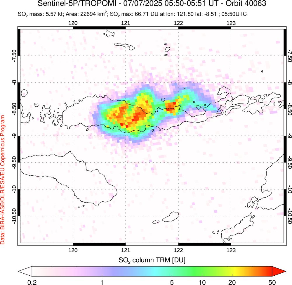
Map of column amounts of sulfur dioxide (SO2) gas in the Lewotobi volcanic plume, measured by the Sentinel-5P/TROPOMI satellite instrument. The map shows SO2 spreading west of the volcano in the upper troposphere.
Thanks Fred. Impressive plume but low SO₂ loading (~6 kt or 0.006 Tg); an order of magnitude lower than the June 17 eruption of #Lewotobi.
08.07.2025 19:19 — 👍 1 🔁 0 💬 0 📌 0
Today, we're launching a dedicated action hub for the crisis threatening NASA science. Find actions, latest news and up-to-date resources at: www.planetary.org/save-nasa-sc... #ProtectNASAScience
01.05.2025 16:10 — 👍 71 🔁 41 💬 2 📌 3
Satellite imagery of nighttime lights using the NOAA-20/VIIRS Day/Night Band ('visible image at night') shows areas of Spain and Portugal still affected by power outages overnight on April 28-29. Images from NASA Worldview. @thenasaearth.bsky.social @noaa.gov
29.04.2025 15:54 — 👍 7 🔁 1 💬 0 📌 0
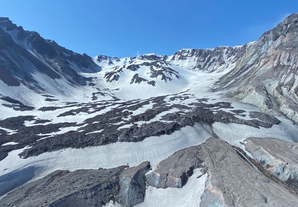
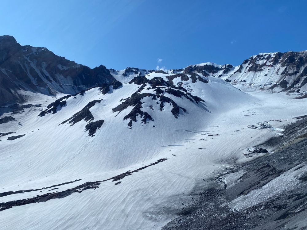
The world's youngest mountain glacier - Crater Glacier at Mount St. Helens #volcano (WA, USA) - formed in 1996 in the amphitheater produced by the May 1980 eruption. The glacier flows around lava domes erupted in 1980-86 and 2004-08. Photos taken in 2023. #WorldGlacierDay 🧪🌋
21.03.2025 16:54 — 👍 34 🔁 7 💬 1 📌 0
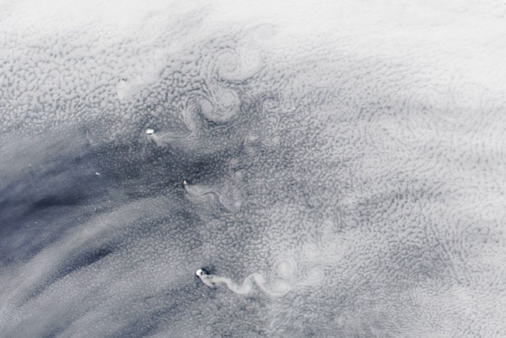
Swirling Skies and Melting Icebergs
The remote South Sandwich Islands can disrupt passing clouds in ways that shed alternating rows of cloud spirals.
🧪🛰️
My colleague @simoncarn.bsky.social and I were consulted for this note by @avoiland.bsky.social to comment on volcanoes and clouds in the South Atlantic.
A nice place to study aerosol-cloud interactions! (and other things of course)
earthobservatory.nasa.gov/images/15404...
17.03.2025 16:05 — 👍 17 🔁 3 💬 1 📌 0
When Spurr last erupted in 1992, volcanic ash & gas clouds (a potential aviation hazard) drifted south over the Pacific NW & Upper Midwest. A fully functional USGS & NOAA is needed to monitor such events & mitigate their impacts. NASA/NOAA satellite data also critical for tracking volcanic clouds.
12.03.2025 22:48 — 👍 24 🔁 7 💬 0 📌 1
Some folks have asked, given recent news, “how do I show my friends/family the impact of NSF?” We have some easy Fact Sheets for you! Here’s a brief thread about this website: new.nsf.gov/about/fact-s... which hosts a ton of useful one-pagers.
08.02.2025 15:31 — 👍 380 🔁 242 💬 2 📌 20
Volcano Notification Service (VNS)
A reminder: If you need to know about volcanic activity in the United States and are concerned that you might not be able to reach USGS websites at some point, PLEASE make sure you sign up for our volcano notification Service: volcanoes.usgs.gov/vns3/ It is a straight-to-email messaging system. 🌋🧪⚒️
01.02.2025 03:41 — 👍 208 🔁 102 💬 9 📌 7
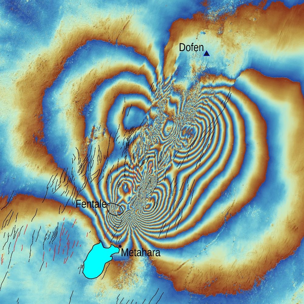
Satellite imagery from @planet.com shows increased steaming in the summit caldera of Fentale volcano (Ethiopia) in the last week. Emissions appear confined to topographic lows - perhaps a meteorological effect (temperature inversion?). @davidmpyle.bsky.social @volckaren.bsky.social 🧪
20.01.2025 00:38 — 👍 15 🔁 6 💬 1 📌 0
#Volcanic SO₂ plume from #Kanlaon #volcano captured and entrained by Super Typhoon #Man-yi (#Pepito) during its passage through the #Philippines. Data from the #geostationary GK-2B GEMS instrument.
19.11.2024 05:51 — 👍 22 🔁 3 💬 0 📌 0
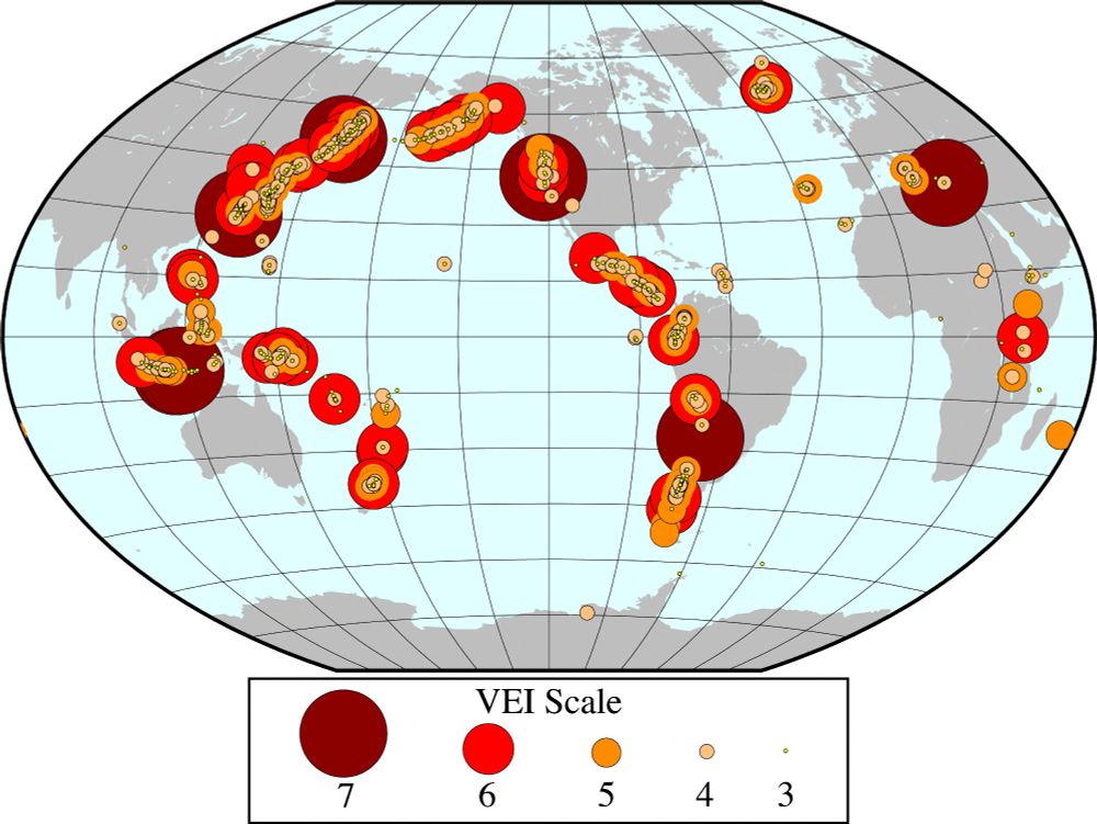
Map of the world with circles of various sizes in shades of red, orange, and yellow. The circle size and color corresponds to size of explosive volcanic eruption that took place. There are far more smaller circles than very large circles, indicating that very large eruptions are (thankfully) less common.
#30DayMapChallenge Day 14: World Map
Large explosive volcanic eruptions during the Holocene plotted by VEI (Volcano Explosivity Index). Volcano data from SI Global Volcanism Program.
15.11.2024 04:58 — 👍 59 🔁 6 💬 3 📌 0

The next massive volcano eruption will cause climate chaos — and we are unprepared
Volcanic activity will be experienced differently in a warmer world. Researchers need to understand these risks and how they could spiral.
No insurer will write a policy for global cooling triggered by a massive 🌋eruption. But we shouldn't ignore a risk just because it's uninsurable.
In this comment led by Markus Stoffel, we argue the risk industry ought to think more seriously about 'Tambora 2.0'.
www.nature.com/articles/d41...
12.11.2024 15:27 — 👍 51 🔁 16 💬 2 📌 3
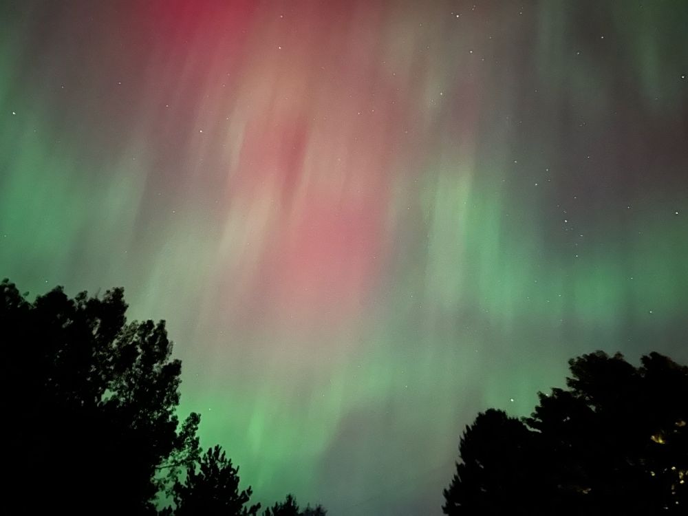
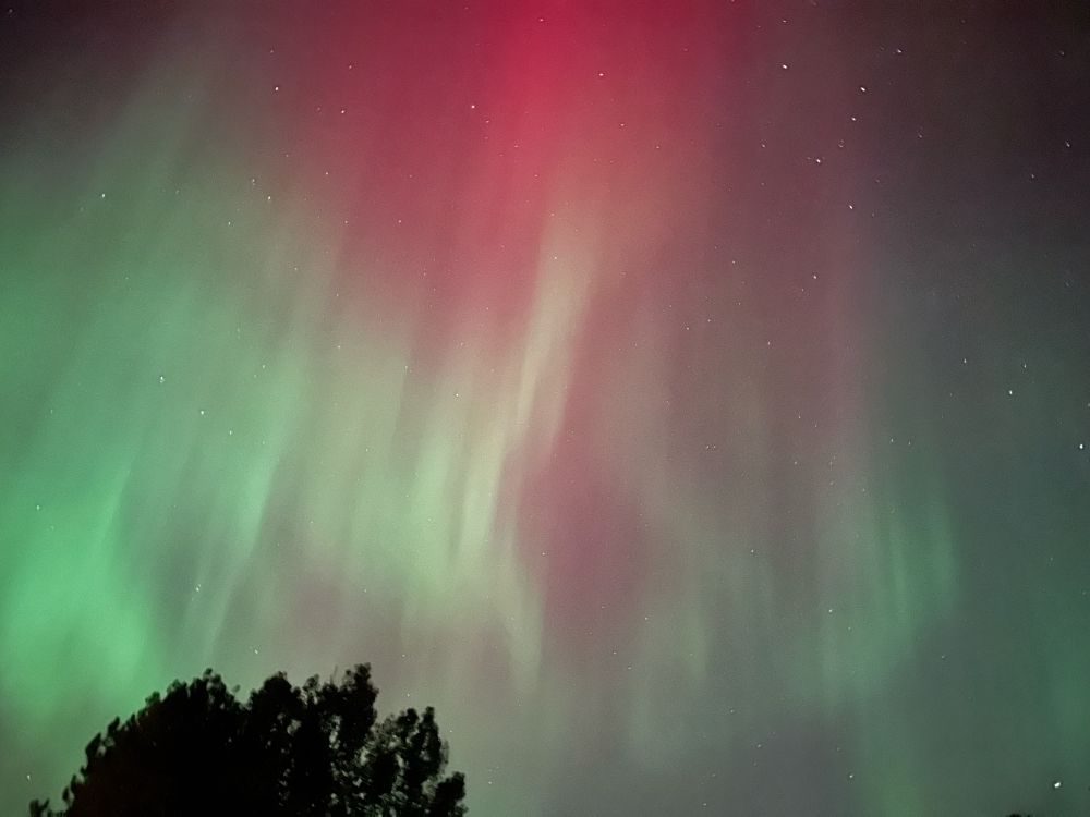
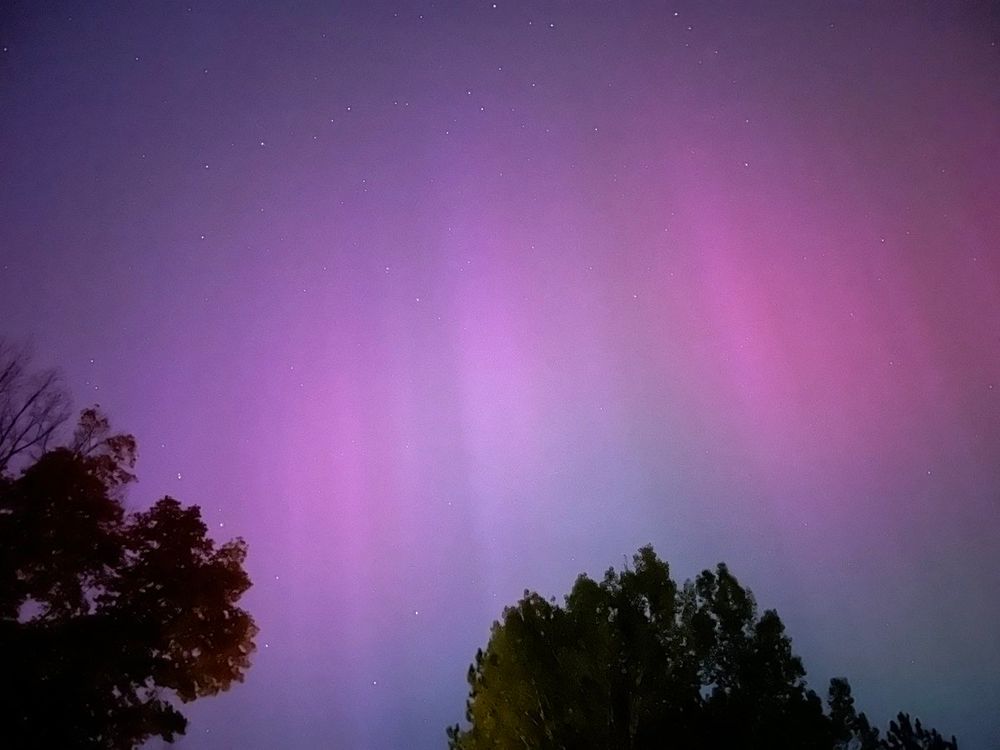
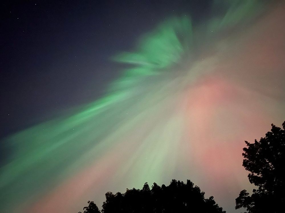
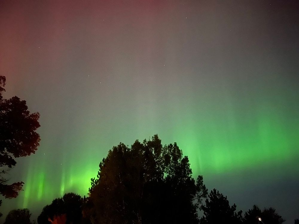
Overhead #aurora in Hancock, #Michigan tonight. #Auroraborealis #northernlights
08.10.2024 04:19 — 👍 7 🔁 0 💬 0 📌 0
Satellite data from @CopernicusEU #Sentinel5P #TROPOMI show a band of #volcanic SO₂ advancing over the NW #UK and #Ireland on Aug 24, behind a cold front. Observations of SO₂ over Europe are set to improve (-> hourly) with the upcoming launch of the #geostationary #Sentinel4.
24.08.2024 21:04 — 👍 0 🔁 0 💬 0 📌 0
Another batch of #volcanic SO₂ en route to the #UK/#Ireland, courtesy of the latest #eruption on #Iceland's #Reykjanes peninsula. Might cause some local #AirQuality impacts in the coming days. @eddy_weather @ScottishEPA
SO₂ data: @NOAA/@NASA @JPSSProgram #NOAA20-#OMPS
23.08.2024 23:51 — 👍 2 🔁 0 💬 1 📌 0
Longer sequence of hourly #GEMS data (daytime only) showing SO₂ emissions from the June 3 #Kanlaon #eruption. On June 5, the upper tropospheric SO₂ cloud was moving west over #SriLanka and S. #India, whilst SO₂ at lower altitudes is dispersing over the southern #Philippines.
05.06.2024 17:25 — 👍 0 🔁 0 💬 0 📌 0
Night sky photographer and explorer for the National Geographic, bridging art and science. babaktafreshi.com
Conducting directed research & engineering to discover solutions to societal problems • Science Serving Society • ral.ucar.edu
We're committed to advancing our understanding of Earth system science, from the ocean to the exosphere, for the betterment of our planet. 🌎 Operated by UCAR and #NSFfunded.
Cutting-edge research, news, commentary, and visuals from the Science family of journals. https://www.science.org
Post-doc researcher in solid Earth geophysics at University of Pisa - Department of Earth Sciences. InSAR 🛰 Tectonics ⛰️ Volcanoes 🌋 Earth Observation 🌍
Eos is a leading source for trustworthy news and perspectives about the Earth and space sciences and their impact. Published by the American Geophysical Union (@agu.org).
Astronaut, back on Earth after 3 spaceflights. For events & media, please write to info@chrishadfield.ca. Order books at http://chrishadfield.ca/books
earthquakes, volcanoes, breaking the continents
Thought follower. Public servant. Male software developer. Alumnus of 18F, the Obama White House, Georgetown's Beeck Center, U.S. Digital Response, the Biden-Harris Transition Team, and the Biden administration. He/him. Charlottesville, VA, USA.
Mammal.
new📘CO2 https://www.harpercollins.com/products/the-story-of-co2-is-the-story-of-everything-peter-brannen?variant=42382167638050
last📘Mass extinctions https://www.harpercollins.com/products/the-ends-of-the-world-peter-brannen?variant=32121859801122
Witnessing and documenting the decimation of Earth Sciences at NASA. A personal and partial view from a veteran scientist employed at one of the centers. Sharing information and occasional comment.
Bipedal meatbag. Professor of volcano stuff on the Island of Hawai‘i.
Work account for @tuffcookie - for daytime lurking because I don't wanna share my personal account with my employers via my work computer.
Social media team contact: 📧 so-me@iavceivolcano.org
Official website: iavceivolcano.org
We are home to the PBS News Hour and @washingtonweekpbs.bsky.social.
Subscribe to our newsletter: https://to.pbs.org/47dcMEJ
Support our work: https://bit.ly/3IXO4xW
More: linktr.ee/pbsnews
Geoscientist/canine caretaker. UAF alum. Based in Alaska
Seismology/Volcanology/Meteorology/Astronomy/Space Weather, & Science Communication
Sometimes successful at photography
See my starter packs for more science!
Planetary foresight and personal climate strategies.
Courses: https://alexsteffen.thinkific.com/
Podcast/newsletter: https://alexsteffen.substack.com/
Consultation: https://app.acuityscheduling.com/schedule/21f79c52
Start here → alexsteffen.com/start
glaciologist @ethzurich and @wslresearch.bsky.social, head of GLAMOS, passionate about mountains