What can Chicago do that LA couldn’t?
07.09.2025 05:10 — 👍 1 🔁 0 💬 1 📌 0
The larger scale factors responsible for the anemic 4CH this summer are technically still present in early August. I’ll wager anomalous height rises end up in W-Canada/Interior NW US before the ISM/building IO MJO retake control.
22.07.2025 22:42 — 👍 0 🔁 0 💬 0 📌 0

I updated the PolarWx model forecasts vs. ERA5 records map to include 2024 in the ERA5 record period (1950-2024, previous maps' period of record was 1950-2023).
The upcoming East US ridge will set near-record annual maximum geopotential heights... the previous record was set in June of last year.
20.06.2025 21:32 — 👍 36 🔁 7 💬 1 📌 0
The Trump-era Dem base resembles the Obama-era GOP base: highly engaged & higher income that vote at higher rates during midterm elections. Dems erred thinking 2022 over-performance would carry into 2024 because it wasn’t driven by Dobbs/Democracy as much as the nature of the electorate itself.
26.05.2025 03:29 — 👍 1 🔁 0 💬 0 📌 0
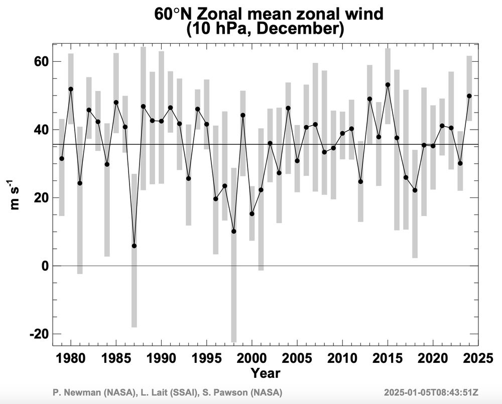
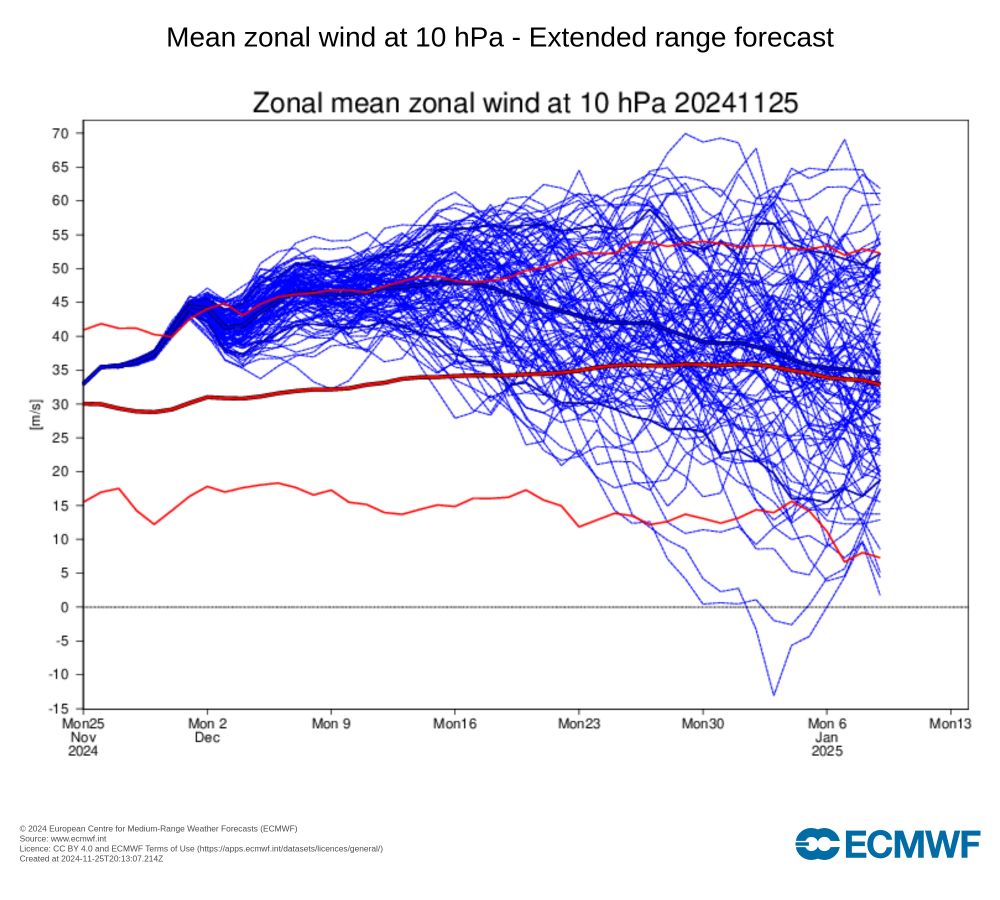
Time series of the mean vortex strength for each December from 1979 to 2024, and its variability within that month.
The Arctic stratospheric polar vortex during December 2024, as measured by the zonal wind at 10 hPa & 60°N, was the third strongest on record for the month since 1979, marginally behind 2015 & 1980, and similar to 2013, per NASA GEOS/MERRA-2 analyses.
ozonewatch.gsfc.nasa.gov/meteorology/...
07.01.2025 22:12 — 👍 16 🔁 5 💬 1 📌 0
9477: Christmas Shoes.
26.12.2024 13:25 — 👍 0 🔁 0 💬 0 📌 0


This image will be in the NASA calendar for 2025. One of the most detailed red sprites I have captured. Plasma physics is both beautiful and wild. Available as a print on my website for those who'd like to support my work
22.11.2024 23:48 — 👍 478 🔁 64 💬 12 📌 5
Land, mountains and tracks of storms are revealed from maximum wind gust speed over a 44 year-long atmosphere simulation at 9km resolution done at @ECMWF for @EERIE_Project #EERIE
#30daymapchallenge
14.11.2024 12:10 — 👍 159 🔁 34 💬 7 📌 3
Oh wow, I see the OMI MJO index has been extended back to 1940 using ERA-5 👀
www.psl.noaa.gov/mjo/mjoindex...
20.09.2024 14:45 — 👍 10 🔁 3 💬 0 📌 0


The colors!
01.07.2024 00:44 — 👍 12 🔁 4 💬 0 📌 0
The eastern Mediterranean heating and the tendency for the East Asian monsoon to break down and spread into IO/west Pac modes can both support the wave sourcing you need over Eurasia to initiate the +CGT pattern.
12.06.2024 13:51 — 👍 1 🔁 2 💬 2 📌 0
So yeah, without getting too hype (is that even possible on Bluesky? lol) I would say this is the most threatening summer we've had in a while for the Midwest to Northeast heat dome. And the background spatial SSTa and pattern are also supportive.
12.06.2024 13:57 — 👍 1 🔁 1 💬 1 📌 0
Interesting. Like soil moisture feedback(s) or something more external/tropical forcing related?
12.06.2024 13:47 — 👍 0 🔁 0 💬 1 📌 0
Big heat in June w/ developing niña tends to be a warning sign for a blowtorch summer. See 2010 and 1988. And 1954 to some extent.
12.06.2024 13:22 — 👍 2 🔁 0 💬 1 📌 0


Skies cleared around ~ 1AM, and holy shieeet. Absolutely breathtaking..I might’ve shed a tear or two.
11.05.2024 09:51 — 👍 11 🔁 1 💬 0 📌 0

It's so beautiful, I might cry.
I have been waiting SO LONG for this to be national, and now it has!
www.wpc.ncep.noaa.gov/heatrisk
22.04.2024 21:05 — 👍 39 🔁 9 💬 2 📌 0
You border on clairvoyant sometimes. Very well done.
03.02.2024 07:58 — 👍 2 🔁 0 💬 0 📌 0

WPC's Probabilistic WSSI (WSSI-P) went operational today!
Link to the webpage: wpc.ncep.noaa.gov/wwd/wssi/pro...
Link to the user guide: wpc.ncep.noaa.gov/wwd/wssi/WSS...
Shout out to Dr. Josh Kastman & Dr. Dana Tobin for the development of this product.
15.12.2023 22:49 — 👍 13 🔁 5 💬 1 📌 0

Synoptic wave train will transport momentum into the Pacific Jet.
The "jet extension" is not unusual (counter to all the hyperbole out there about it), and its behavior is not entirely based on the descending East Asian High either. The diabatic response from the Niño forcing/structure and the subtropical wave train are also adding momentum to the jet, too.
14.12.2023 14:29 — 👍 8 🔁 1 💬 1 📌 0


GEFS & ECMWF subseasonal forecasts now very confident in a notably weakened polar vortex by early January, with a substantial risk of a major sudden stratospheric warming. Even if a major SSW does not occur, such a weakened vortex would likely have some tropospheric effects.
12.12.2023 13:33 — 👍 14 🔁 5 💬 3 📌 0

You don't get a classic gill-response like this often in the tropics like what we're seeing around Dec-8th. It's a thing of beauty to see theoretical tropical meteorology pop up in the real-world.
04.12.2023 17:30 — 👍 8 🔁 2 💬 0 📌 0
Keep a level-head going forward as we get inundated with promises of a big pattern change, severe Arctic cold, etc. The grift is simple: forecast extreme cold all the time so that when it does happen to occur, the forecaster basks in the accolades.
02.12.2023 18:30 — 👍 11 🔁 1 💬 2 📌 0