TWC issues Area Forecast Discussion (AFD) at Aug 12, 2:11 PM MST
at Tue, 12 Aug 2025 21:11:31 +0000 via IEMbot
Additional Details Here.
12.08.2025 21:27 — 👍 1 🔁 0 💬 0 📌 0
TWC issues Area Forecast Discussion (AFD) at Aug 12, 10:10 AM MST
at Tue, 12 Aug 2025 17:10:55 +0000 via IEMbot
Additional Details Here.
12.08.2025 17:26 — 👍 0 🔁 0 💬 0 📌 0
The Storm Prediction Center issues Day 1 Marginal Convective Risk at Aug 12, 16:28z for portions of TWC
at Tue, 12 Aug 2025 16:30:38 +0000 via IEMbot
Additional Details Here.
12.08.2025 16:46 — 👍 0 🔁 0 💬 0 📌 0
TUCSON AZ Aug 12
Climate Report:
High: M
Low: 81
Precip: 0.0"
Snow: Missing
at Tue, 12 Aug 2025 14:35:32 +0000 via IEMbot
Additional Details Here.
12.08.2025 14:46 — 👍 1 🔁 0 💬 0 📌 0
The Storm Prediction Center issues Day 1 Marginal Convective Risk at Aug 12, 11:48z for portions of TWC
at Tue, 12 Aug 2025 11:51:49 +0000 via IEMbot
Additional Details Here.
12.08.2025 12:06 — 👍 1 🔁 0 💬 0 📌 0
TWC issues Public Information Statement (PNS) at Aug 12, 3:01 AM MST ...Rainfall Reports (24-hour) across Southeast Arizona (Monday 8/11 Into Early Tuesday Morning 8/12)... via IEMbot
Additional Details Here.
12.08.2025 10:06 — 👍 0 🔁 0 💬 0 📌 0
TWC issues Area Forecast Discussion (AFD) at Aug 12, 2:08 AM MST
at Tue, 12 Aug 2025 09:11:12 +0000 via IEMbot
Additional Details Here.
12.08.2025 09:27 — 👍 0 🔁 0 💬 0 📌 0
TUCSON AZ Aug 11
Climate Report:
High: 104
Low: 84
Precip: 0.0"
Snow: Missing
at Tue, 12 Aug 2025 07:34:27 +0000 via IEMbot
Additional Details Here.
12.08.2025 07:46 — 👍 1 🔁 0 💬 0 📌 0
The Storm Prediction Center issues Day 1 Marginal Convective Risk at Aug 12, 5:38z for portions of TWC
at Tue, 12 Aug 2025 05:41:59 +0000 via IEMbot
Additional Details Here.
12.08.2025 05:47 — 👍 0 🔁 0 💬 0 📌 0
DOUGLAS AZ Aug 11
Climate Report:
High: 98
Low: 67
Precip: 0.0"
Snow: Missing
at Tue, 12 Aug 2025 00:49:22 +0000 via IEMbot
Additional Details Here.
12.08.2025 01:06 — 👍 0 🔁 0 💬 0 📌 0
TWC issues Area Forecast Discussion (AFD) at Aug 11, 1:41 PM MST
at Mon, 11 Aug 2025 20:42:02 +0000 via IEMbot
Additional Details Here.
11.08.2025 20:46 — 👍 0 🔁 0 💬 0 📌 0
The Storm Prediction Center issues Day 2 Marginal Convective Risk at Aug 11, 17:09z for portions of TWC
at Mon, 11 Aug 2025 17:11:10 +0000 via IEMbot
Additional Details Here.
11.08.2025 17:26 — 👍 0 🔁 0 💬 0 📌 0
The Storm Prediction Center issues Day 1 Isolated Dry Thunderstorm Fire Weather Risk at Aug 11, 16:24z for portions of TWC
at Mon, 11 Aug 2025 16:25:59 +0000 via IEMbot
Additional Details Here.
11.08.2025 16:26 — 👍 0 🔁 0 💬 0 📌 0
TWC issues Area Forecast Discussion (AFD) at Aug 11, 8:57 AM MST
at Mon, 11 Aug 2025 15:58:21 +0000 via IEMbot
Additional Details Here.
11.08.2025 16:06 — 👍 0 🔁 0 💬 0 📌 0
TUCSON AZ Aug 11
Climate Report:
High: M
Low: 84
Precip: 0.0"
Snow: Missing
at Mon, 11 Aug 2025 14:33:14 +0000 via IEMbot
Additional Details Here.
11.08.2025 14:46 — 👍 0 🔁 0 💬 0 📌 0
TWC issues Area Forecast Discussion (AFD) at Aug 11, 2:35 AM MST
at Mon, 11 Aug 2025 09:35:24 +0000 via IEMbot
Additional Details Here.
11.08.2025 09:46 — 👍 0 🔁 0 💬 0 📌 0
TUCSON AZ Aug 10
Climate Report:
High: 101
Low: 81
Precip: 0.0"
Snow: Missing
at Mon, 11 Aug 2025 07:36:55 +0000 via IEMbot
Additional Details Here.
11.08.2025 07:46 — 👍 0 🔁 0 💬 0 📌 0
The Storm Prediction Center issues Day 2 Isolated Dry Thunderstorm Fire Weather Risk at Aug 11, 6:35z for portions of TWC
at Mon, 11 Aug 2025 06:35:56 +0000 via IEMbot
Additional Details Here.
11.08.2025 06:47 — 👍 0 🔁 0 💬 0 📌 0
The Storm Prediction Center issues Day 1 Isolated Dry Thunderstorm Fire Weather Risk at Aug 11, 6:04z for portions of TWC
at Mon, 11 Aug 2025 06:05:26 +0000 via IEMbot
Additional Details Here.
11.08.2025 06:06 — 👍 0 🔁 0 💬 0 📌 0
The Storm Prediction Center issues Day 1 Marginal Convective Risk at Aug 11, 1:01z for portions of TWC
at Mon, 11 Aug 2025 01:03:38 +0000 via IEMbot
Additional Details Here.
11.08.2025 01:07 — 👍 0 🔁 0 💬 0 📌 0
DOUGLAS AZ Aug 10
Climate Report:
High: 96
Low: 65
Precip: Trace
Snow: Missing
at Mon, 11 Aug 2025 00:36:05 +0000 via IEMbot
Additional Details Here.
11.08.2025 00:47 — 👍 0 🔁 0 💬 0 📌 0
TUCSON AZ Aug 10
Climate Report:
High: 101
Low: 81
Precip: 0.0"
Snow: Missing
at Mon, 11 Aug 2025 00:36:06 +0000 via IEMbot
Additional Details Here.
11.08.2025 00:47 — 👍 1 🔁 0 💬 0 📌 1
Weather Prediction Center issues Mesoscale Precipitation Discussion #898 concerning HEAVY RAINFALL...FLASH FLOODING POSSIBLE
at Sun, 10 Aug 2025 23:29:50 +0000 via IEMbot
Additional Details Here.
10.08.2025 23:47 — 👍 0 🔁 0 💬 0 📌 0
TWC expires Severe Thunderstorm Warning for Cochise, Graham [AZ]
at Sun, 10 Aug 2025 22:36:46 +0000 via IEMbot
Additional Details Here.
10.08.2025 22:46 — 👍 0 🔁 0 💬 0 📌 0
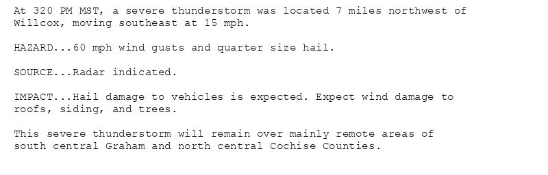
At 320 PM MST, a severe thunderstorm was located 7 miles northwest of
Willcox, moving southeast at 15 mph.
HAZARD...60 mph wind gusts and quarter size hail.
SOURCE...Radar indicated.
IMPACT...Hail damage to vehicles is expected. Expect wind damage to
roofs, siding, and trees.
This severe thunderstorm will remain over mainly remote areas of
south central Graham and north central Cochise Counties.
🚨 Severe Thunderstorm Warning issued August 10 at 3:20PM MST until August 10 at 3:45PM MST by NWS Tucson AZ 🚨
Additional Details Here.
10.08.2025 22:30 — 👍 0 🔁 0 💬 0 📌 0
TWC continues Severe Thunderstorm Warning [wind: 60 MPH (RADAR INDICATED), hail: 1.00 IN (RADAR INDICATED)] for Cochise, Graham [AZ] till 3:45 PM MST
at Sun, 10 Aug 2025 22:20:45 +0000 via IEMbot
Additional Details Here.
10.08.2025 22:26 — 👍 0 🔁 0 💬 0 📌 0
TWC issues Severe Thunderstorm Warning [wind: 60 MPH (RADAR INDICATED), hail: 1.00 IN (RADAR INDICATED)] for Cochise, Graham [AZ] till 3:45 PM MST
at Sun, 10 Aug 2025 21:54:14 +0000 via IEMbot
Additional Details Here.
10.08.2025 22:06 — 👍 0 🔁 0 💬 0 📌 0
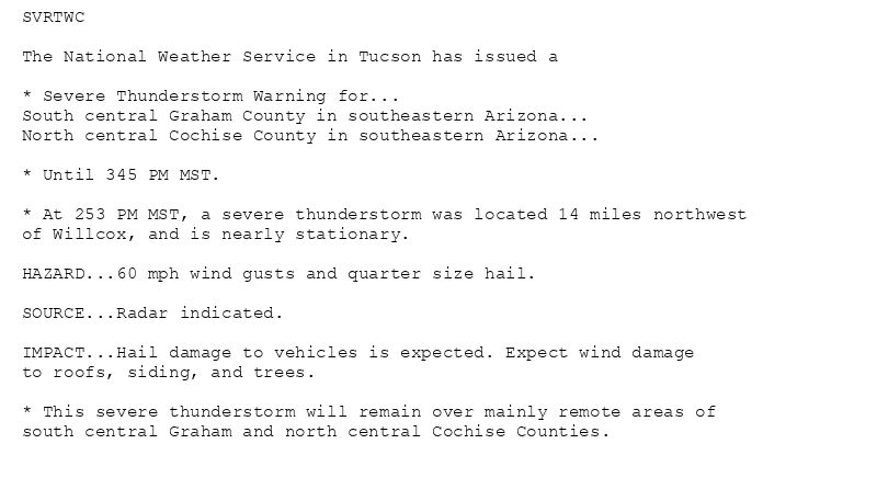
SVRTWC
The National Weather Service in Tucson has issued a
* Severe Thunderstorm Warning for...
South central Graham County in southeastern Arizona...
North central Cochise County in southeastern Arizona...
* Until 345 PM MST.
* At 253 PM MST, a severe thunderstorm was located 14 miles northwest
of Willcox, and is nearly stationary.
HAZARD...60 mph wind gusts and quarter size hail.
SOURCE...Radar indicated.
IMPACT...Hail damage to vehicles is expected. Expect wind damage
to roofs, siding, and trees.
* This severe thunderstorm will remain over mainly remote areas of
south central Graham and north central Cochise Counties.
🚨 Severe Thunderstorm Warning issued August 10 at 2:54PM MST until August 10 at 3:45PM MST by NWS Tucson AZ 🚨
Additional Details Here.
10.08.2025 22:00 — 👍 0 🔁 0 💬 0 📌 0
TWC expires Severe Thunderstorm Warning for Graham, Greenlee [AZ]
at Sun, 10 Aug 2025 20:51:50 +0000 via IEMbot
Additional Details Here.
10.08.2025 21:06 — 👍 0 🔁 0 💬 0 📌 0
TWC continues Severe Thunderstorm Warning [wind: 60 MPH (RADAR INDICATED), hail: 1.00 IN (RADAR INDICATED)] for Graham, Greenlee [AZ] till 2:00 PM MST
at Sun, 10 Aug 2025 20:40:34 +0000 via IEMbot
Additional Details Here.
10.08.2025 20:46 — 👍 0 🔁 0 💬 0 📌 0

