Original post on mstdn.ca
Le Téléjournal Ontario a discuté avec nous du coût élevé des portes palières.
CodeRedTO: « Si nous devons dépenser des milliards pour augmenter la capacité de la CTT, d'autres projets devraient être envisagés, comme le WaterFront LRT de l'est, promis depuis des décennies »
(à partir de 4:30) […]
21.06.2025 13:38 — 👍 0 🔁 1 💬 0 📌 0
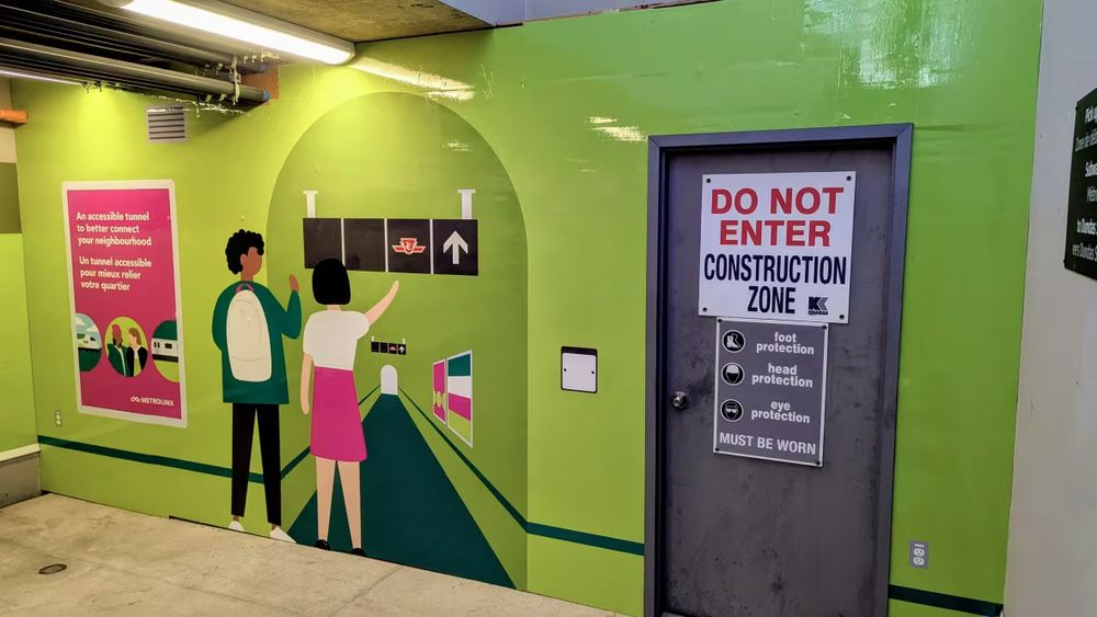
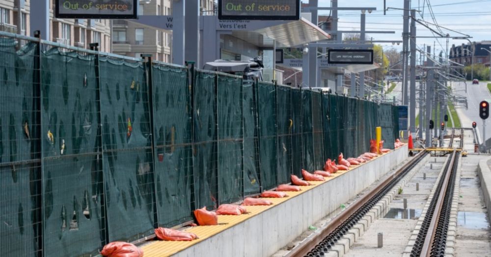
A colourful mural painted over hoarding blocking a construction zone at Dundas West TTC station. CBC caption reads: Signage at UP Express Bloor Station shows where the passenger tunnel to the Dundas West subway station will be when it opens.
Tunnel connecting UP Express to TTC's Dundas West station under construction after long delay
CodeRedTO: "it should be something that we are able to pull off in a little *less* than 10 years"
https://www.cbc.ca/news/canada/toronto/up-express-ttc-tunnel-1.7563769 […]
[Original post on mstdn.ca]
21.06.2025 00:02 — 👍 1 🔁 3 💬 0 📌 2
Original post on mastodon.social
Build it to respect customers' time and They Will Ride:
"Passengers made more than 52 million trips by train between Beijing and Shanghai last year, while only about 8.6 million people took a flight between the two cities.
Business travellers especially are increasingly viewing high-speed rail […]
28.05.2025 11:37 — 👍 2 🔁 25 💬 0 📌 0
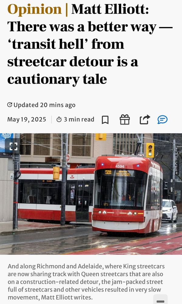
Screenshot of linked article with headline, photo of streetcar, and caption as follows:
Opinion | Matt Elliott:
There was a better way — 'transit hell' from streetcar detour is a cautionary tale
Photo
And along Richmond and Adelaide, where King streetcars are now sharing track with Queen streetcars that are also on a construction-related detour, the jam-packed street full of streetcars and other vehicles resulted in very slow movement, Matt Elliott writes.
TTC streetcar detour timeline:
Jan 2025: detour, but parking/ stopping/ loading restrictions + dedicated transit lanes.
March: transit lanes removed from plan
April: restrictions removed from plan
May: detour begins poorly
@GraphicMatt in the Toronto Star […]
[Original post on mstdn.ca]
19.05.2025 20:49 — 👍 0 🔁 2 💬 0 📌 0
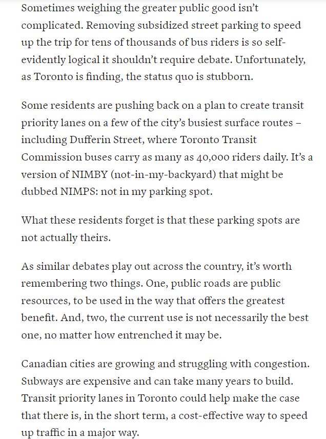
Sometimes weighing the greater public good isn’t complicated. Removing subsidized street parking to speed up the trip for tens of thousands of bus riders is so self-evidently logical it shouldn’t require debate. Unfortunately, as Toronto is finding, the status quo is stubborn.
Some residents are pushing back on a plan to create transit priority lanes on a few of the city’s busiest surface routes – including Dufferin Street, where Toronto Transit Commission buses carry as many as 40,000 riders daily. It’s a version of NIMBY (not-in-my-backyard) that might be dubbed NIMPS: not in my parking spot.
What these residents forget is that these parking spots are not actually theirs.
As similar debates play out across the country, it’s worth remembering two things. One, public roads are public resources, to be used in the way that offers the greatest benefit. And, two, the current use is not necessarily the best one, no matter how entrenched it may be.
Canadian cities are growing and struggling with congestion. Subways are expensive and can take many years to build. Transit priority lanes in Toronto could help make the case that there is, in the short term, a cost-effective way to speed up traffic in a major way.
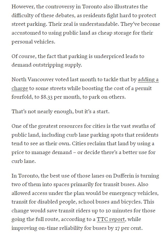
However, the controversy in Toronto also illustrates the difficulty of these debates, as residents fight hard to protect street parking. Their zeal is understandable. They’ve become accustomed to using public land as cheap storage for their personal vehicles.
Of course, the fact that parking is underpriced leads to demand outstripping supply.
North Vancouver voted last month to tackle that by adding a charge to some streets while boosting the cost of a permit fourfold, to $8.33 per month, to park on others.
That’s not nearly enough, but it’s a start.
One of the greatest resources for cities is the vast swaths of public land, including curb lane parking spots that residents tend to see as their own. Cities reclaim that land by using a price to manage demand – or decide there’s a better use for curb lane.
In Toronto, the best use of those lanes on Dufferin is turning two of them into spaces primarily for transit buses. Also allowed access under the plan would be emergency vehicles, transit for disabled people, school buses and bicycles. This change would save transit riders up to 10 minutes for those going the full route, according to a TTC report, while improving on-time reliability for buses by 17 per cent.
For comparison, Toronto politics was convulsed early last decade with debate over whether to build a light rail line in Scarborough or extend a subway, the latter approach costing a premium then pegged at $1.1-billion. Coincidentally, that subway extension was projected to save downtown-bound transit riders 10 minutes.
While the capital costs to put bus-only lanes on Dufferin are not yet public, it’s safe to say that it would cost an awful lot less than that subway extension.
Not having the Dufferin bus stuck as much in traffic would also save the TTC money, the report says, while the improved service is expected to attract nearly 3,000 new daily transit riders to the route. Net annual benefit to the agency: more than $3-million.
A counterargument, from a group Protect Dufferin that speaks for some homeowners on the route, is that their parking needs are being ignored. One way to assess the competing needs is to look at the relative benefit of better transit versus convenient parking.
The value of the bus improvement is reasonably easy to quantify. It is projected to go faster, be more reliable, carry more people and boost revenues.
The true value of the parking spaces is harder to determine, because Toronto has long underpriced its public land. As in much of the central city, parking spaces along Dufferin are a mix of free, metered and permit parking. Permits in Toronto are priced below market rates and work out to less than $1 a day, if the homeowner has nowhere to park on their own property, or about $3.50 if they do.
Urban curb lanes are valuable real estate. If they were priced accordingly Toronto would quickly find out how much NIMPS really want those spaces. And that should demonstrate that city hall has the latitude to roll out bus-only lanes much more broadly. The public good demands it.
"Removing subsidized street parking to speed up the trip for tens of thousands of bus riders is so self-evidently logical it shouldn’t require debate."
Globe editorial supports transit improvements on Dufferin and Bathurst […]
[Original post on mstdn.ca]
18.05.2025 16:12 — 👍 9 🔁 10 💬 0 📌 0
Original post on mstdn.ca
After 1st week, TTC has identified challenges with King streetcar diversion and announced an adjustment to reduce King/Spadina friction.
News Release
1/2
"To ensure the TTC is providing the best service possible during the King/Church intersection closure, a small adjustment to the 504 King […]
16.05.2025 17:40 — 👍 1 🔁 1 💬 0 📌 0
King/Church Diversion Observations May 12, 2025
Today was the first weekday of the King/Church construction diversions. I watch things evolve via NextBus through the morning peak, and then visited King/Spadina during the PM peak. A caveat: Mondays are light traffic days. There was no Gardiner backlog at all on Spadina. Later in the week will likely be more challenging.
During the AM peak, the service on 504 King and 503 Kingston Road did not load properly, and many vehicles were clumped together. This took quite a while to unscramble, and there were big service gaps. The 504 buses also ran in packs and huddled together at Wolseley Loop, at one point six of them representing about 20 minutes worth of service at the scheduled headway. The peak period did not encounter queueing frequently at points where streetcars turn because of many wide service gaps. When a bunch of cars arrived, they queued one by one awaiting their turn, but then the intersections would open up again even though in theory there should always have been transit service waiting.
In the PM peak at King/Spadina, the major sources of traffic were pedestrians, cyclists and transit in that order. I observed that the traffic signal cycle time was 110 seconds (1’50”). This means that there are 32.7 opportunities (3600/110) per hour for a turn to/from Spadina. The nature of the intersection is that only one streetcar can make the turn per cycle.
The combined scheduled service trying to make the EtoN turn per hour at King & Spadina in the PM peak is 23 streetcars.
Route| Headway| Cars/Hour
---|---|---
503 Kingston Road| 8′| 7.5
504 King Car| 10′| 6.0
508 Lake Shore| 20′| 3.0
511 Bathurst Car| 9′| 6.5
Total| | 23
Stir in 12 510 Spadinas straight through northbound on a 5′ headway. When there is a 510 (or any other car) serving the farside NB stop it blocks any car waiting to turn off of King. In a 45 minute visit, I saw this happen four times, and one car missed two turning opportunities because of closely-spaced Spadina cars blocking the stop.
Depending on arrival times and bunching, more vehicles can queue up here than there are cycles to accommodate them. This was under probably the best general traffic conditions we will see.
There were traffic wardens, but they left just before 5pm. The biggest problem was pedestrians blocking turning streetcars which do not have a protected turn phase EB on King. There is a WB advanced green because autos are forced to turn off King here, but there is no advanced green for eastbound streetcars.
The large volume of riders transferring from eastbound streetcars to buses adds to the already substantial pedestrian volumes at this intersection.
The Traffic Wardens did not reliably ensure that streetcars got “first dibs” on turning, and after they left, pedestrian interference became worse.
I boarded a 504 King eastbound at about 5:10. There was congested traffic over the route across to Church especially on Adelaide and it took over 15 minutes to get from York to Church. Some people complain about space “wasted” by bike lanes, but it was the left turn lane that was almost always empty. Some traffic used it to scoot around stopped streetcars!
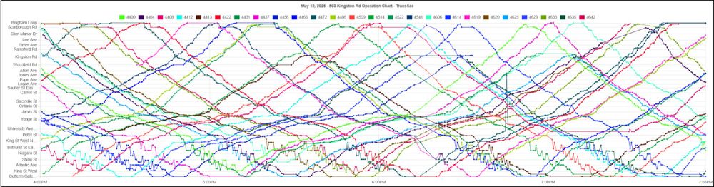
The severe congestion can be seen in the TransSee maps of service for 504 King and 503 Kingston Road below. The tracking lines for the diversion area are almost horizontal for an extended period. Note that the problem is mainly eastbound (lines reading bottom to top).
Tracking data for routes 503 and 504, May 12, 2025, 4pm to 7pm. From TransSee.ca.
I rode a King car east from Spadina and it took a very long time to emerge from the diversion. The car went from 6 minutes early at King on Spadina to 11 minutes late at Queen and Church. Note the length of time spent approaching King and Spadina inching along the street about one carlength at a time. Other locations where the car crept along are also clear in the tracking data.
Tracking data for car 4634. Source TransSee.ca.
Among the problems enroute were:
* Congestion on Queen thanks to stopped vehicles and construction in the curb lanes.
* Autos infilling Adelaide Street eastbound leaving no room for a streetcar to merge from York Street onto Adelaide. We were eventually rescued by a Traffic Warden.
* Extremely slow progress across Adelaide thanks to a traffic backlog from Church Street.
* Extremely slow progress on Church Street thanks to a traffic backlog from Queen Street. My car actually fouled the Church/Adelaide intersection as it was unable to complete the EtoN turn in more than one traffic signal cycle.
Ridership on the car was very light and most people got off when the car turned off King onto Spadina. They transferred to the King shuttle buses which were running irregularly and often bunched. These buses were also trapped in the traffic queue eastbound to Spadina of streetcars waiting to turn. (In the chart below, the size of the dot represents the degree of crowding on the vehicle.
Tracking data for 504C and 504D shuttle buses May 12, 2025, 4pm to 7pm. From TransSee.ca.
For those who want to watch the wandering streetcars and buses on NextBus, here is a link. This will open a combined display of routes 501, 503, 504, 510 and 511. The map can be scaled to zoom in to the area of interest. Displays of operating charts on transsee.ca are free for TTC streetcar routes.
Over coming days I will keep an eye on service performance over the diversion, and once a few weeks’ data have accumulated will delve into the details.
### Share this:
* Click to share on X (Opens in new window) X
* Click to share on Facebook (Opens in new window) Facebook
*
Like Loading...
A review of day one by @swanboatsteve.bsky.social
Observations of the King/Church construction diversions for May 12: https://stevemunro.ca/2025/05/12/king-church-diversion-observations-may-12-2025/ Things did not go well.
13.05.2025 09:50 — 👍 0 🔁 1 💬 0 📌 0
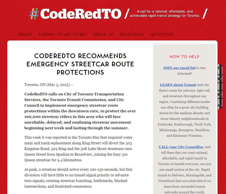
Screenshot from linked press release with CodeRedTO branding
CodeRedTO Recommends Emergency Streetcar Route Protections
https://coderedto.com/coderedto-recommends-emergency-streetcar-route-protections/
#Toronto #TOPoli #TTC #Metrolinx #Transit #PublicTransit
05.05.2025 15:37 — 👍 0 🔁 1 💬 0 📌 0
Screenshot from linked press release with CodeRedTO branding
CodeRedTO Recommends Emergency Streetcar Route Protections
https://coderedto.com/coderedto-recommends-emergency-streetcar-route-protections/
#Toronto #TOPoli #TTC #Metrolinx #Transit #PublicTransit
05.05.2025 15:37 — 👍 0 🔁 1 💬 0 📌 0
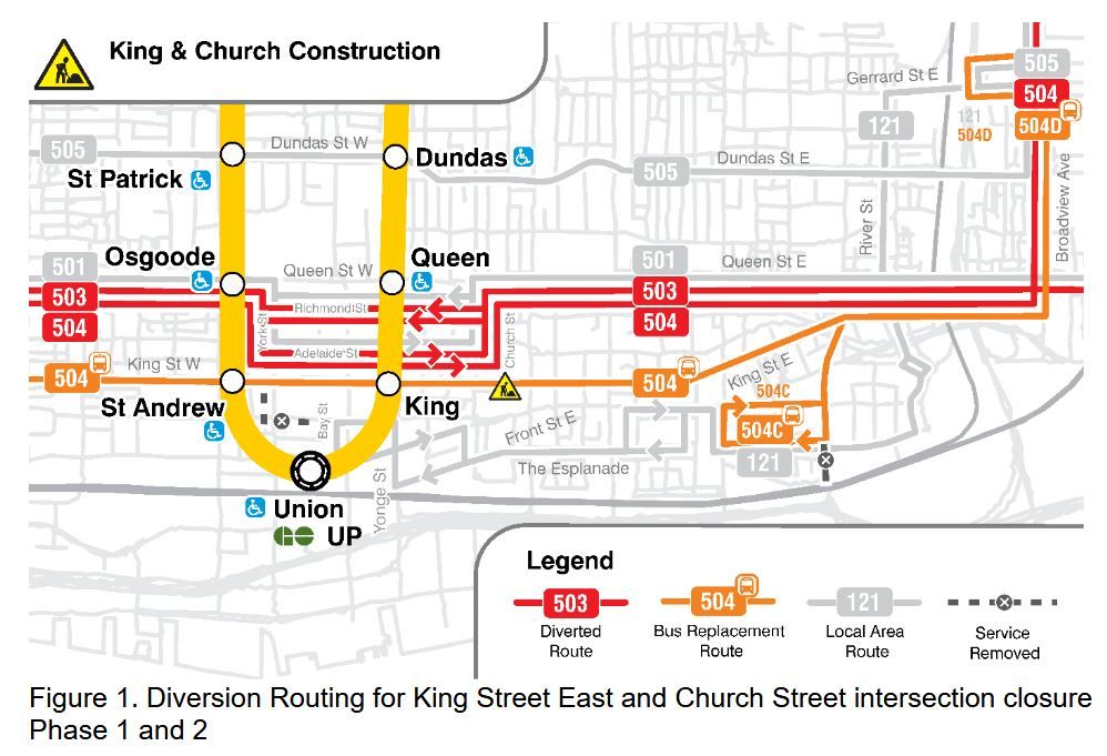
King-Church Construction and Traffic Effects
Major changes are coming to downtown streetcar routes on May 11 with the next schedule change. This will accommodate a combination of water main replacement, track reconstruction and streetcar overhead upgrades mainly at King and Church. Work is expected to require diversions until the October schedule change on Thanksgiving weekend.
The TTC has not yet issued the details from which I would build the usual service change article, but the effects of work an King and Church have been known for some time through the Annual Service Plan and through a City report on the project. (The original report and recommendations were amended at the recent Council meeting to lessen the effect of various proposed lane closures.) Service levels have been published via the electronic version of schedules used by trip planning apps. The information about vehicles/hour at various locations is taken from those schedules.
(As an aside, the TTC website has still not been updated to include the 2025 Service Plan even though it was approved by the Board in January.)
With the concentration of transit service through various intersections, and the added complexity that most vehicles will make turns at these locations, there simply will not be enough capacity even under ideal conditions. It is no secret that “ideal” is a word rarely appropriate for transit operations downtown thanks to the lack of robust traffic management and real transit priority.
In past years, the diversion of services from King Street around the TIFF street fair created problems for transit travel times and reliability, but this lasted for a brief period. The planned diversions for King/Church will last through the summer.
Many of the water mains in the “old” city have been in service for over a century. Other parts of King Street have seen renewal, occasionally on an emergency basis following a break and sink hole.
The special trackwork at the King/Church intersection has been in bad shape for some time, and was overdue for replacement. Previous reconstructions were in 1983 and 2003. Other competing construction projects got in the way, and the track conditions have worsened year by year. There are many patches, and a well-deserved slow order unlike the standing practice even at freshly rebuilt junctions.
This intersection is also old enough that it predates the era of panel track construction where pre-welded sections are trucked in and assembled on site. This replaced the older style of tracks assembled piece-by-piece and often not welded robustly if at all. TTC has not yet been through its entire inventory of “old” track given the 20-30 year cycle depending on the level of service, wear, and disintegration at intersections.
Other work planned for this period of suspended streetcar service is the reconstruction of overhead on King and on the Distillery branch for pantograph-only operation.
Closing King & Church for an extended period concurrently with the Ontario Line construction at Queen & Yonge will add to the traffic snarls downtown. The City talks about using Traffic Agents to manage key intersections, but whether they provide enough people at enough places at enough times remains to be seen.
**_Routes Diverting off of King Street_**
Three routes are affected: 504 King, 503 Kingston Road and 508 Lake Shore.
The 504 King service will be broken into three sections:
* A 504 streetcar service between Broadview to Dundas West Stations operating via the same route as 501 Queen between the Don Bridge and Spadina.
* A 504C bus shuttle from Wolseley Loop south on Bathurst and east on King terminating at Broadview & Gerrard.
* A 504D bus shuttle from Wolseley Loop south on Bathurst, east on King and south on Sumach to Front & Cherry. Buses will loop via [to be announced] and will _not_ serve Distillery Loop.
The 503 Kingston Road service will be changed so that its western terminus shifts from York Street to Dufferin Loop. Cars will follow the same route as the 504 King via Queen from the Don Bridge to Spadina, then shift south onto King to follow the pre-diversion 504B route to Dufferin.
508 Lake Shore cars will follow the same route as 504 King.
Source: City Report at p. 5
For part of the construction period, King/Church will be impassible even to the replacement bus service and it will divert south to Wellington and Front.
Source: City Report at p. 5
These maps do not tell the whole story because another set of construction diversions will overlap the King/Church changes until the next schedule change in late June.
Although water main work at Bathurst/Fleet/Lakeshore is now complete, track work continues there and on Bathurst Street further north. 511 Bathurst streetcars will continue to divert east via King to Spadina looping via Adelaide and Charlotte. The 511B shuttle bus will be shortened from Wolseley Loop at Queen to an on-street loop via King, Portland and Richmond to Bathurst Street.
509 shuttle buses continue operating between Exhibition Loop and Queens Quay Loop at Spadina. 510 streetcars continue operating to Union Station.
The combined effect of the diversions will be greater than during the total meltdown of King service in 2024 when all cars diverted north via Church to Queen because volumes of other routes (510 Spadina, 511 Bathurst and 501 Queen) will be added to the King services, and more intersections will be affected over a wider area.
### **_Vehicle Congestion on King/Church Diversions_**
Several routes will overlap in the diversion area, especially at Spadina and at Bathurst, and their routes will involve many turns that, even with some transit priority assistance, will tax intersection capacity.
In addition, the 511 Bathurst service will loop via King, Spadina, Adelaide and Charlotte, and the 511B Bathurst shuttle will loop via King, Portland and Richmond. This will add to the turning demand at Spadina and at Bathurst, at least until the construction on Bathurst at Fleet and associated diversions end in late June.
The intersections affected by substantially increased transit turning volumes are:
* King & Bathurst
* King & Spadina
* Spadina & Adelaide
* Spadina & Queen
* Queen & York
* York & Richmond
* York & Adelaide
* Church & Richmond
* Church & Adelaide
* Queen & Church
The number of vehicles scheduled per hour will be much higher than the intersections now handle. The City plans to provide Traffic Agents at key intersections, but the large volumes of transit vehicles continue outside of peak periods when Agents are usually deployed, and weekend numbers are similar. This is not a problem for a few hours a day, nor for a few locations.
At **_King and Spadina_** , there will be from 18-24 left turns per hour eastbound. There is no transit priority signal to assist these turns.
In addition, there will be the through north-south service on 510 Spadina (yellow, top band below). Collectively 25-36 cars/hour will attempt to use the farside stop northbound on Spadina.
For technical reasons related to intersection geometry, a white bar signal cannot be implemented in the standard way used by the City/TTC at turns. However, the volume of transit left turns all day is such that a transit left turn should simply be provided at all times without the complexity of vehicle detection. There is a similar issue at Queen westbound where the detection point for left turning streetcars is beyond the stop line. A further problem at King is that the eastbound electric switch will be disabled and detection of turning streetcars through it will be impossible.
At **_Adelaide and Spadina_** , the 511 Bathurst cars (green, second stripe from the top) will turn off Spadina to Adelaide. There is a white bar priority signal to assist the turn, but the intersection is often clogged, and turning cars could block the northbound streetcar traffic.
At **_King and Spadina_** southbound the situation is similar to northbound except that there are no turning 511 Bathurst cars (they come straight west on King from Charlotte Loop). From 12-18 cars/hour will make the turn south to west onto King and the rest, the 510 Spadina service (yellow, top band below), will run straight through. However, cars will stop at the passenger island adding to the time they occupy the area near the intersection.
At **_Queen and Spadina_** northbound, there will be a combination of 510 Spadina cars (yellow, top band below) and the routes diverting from King Street. There is a transit priority white bar for turns at this location of which there will be 12-18/hour.
Eastbound from **_Queen and Spadina_** , the diverting routes will join 501 Queen for their trip via Queen, York, Adelaide and Church back to Queen Street. The vehicle volumes will be substantially higher than those now operated by only the 501 Queen (yellow, top band) today with 18-25 streetcars/hour making all of the turns enroute.
At **_Queen and Spadina_** westbound, the volumes will be similar to eastbound. The 501 Queen cars will use the westbound stop on Queen adding a potential delay to diverting cars on other routes waiting to make the left turn. There is no transit priority signal to assist with this turn.
The volume of streetcars shown here also applies to the turns enroute on the diversion at Church, Richmond, York and Queen, and far more streetcars will attempt these turns than today’s service with only the 501 Queen.
At **_Bathurst and King_** , most of the vehicles arriving southbound will turn east. This includes the 511 Bathurst streetcars, and the 504C/D replacement buses which will use Wolseley Loop at Queen Street as their turnaround. The northbound 511B shuttle bus will loop via King, Portland and Richmond.
The chart below shows the number of vehicles. Only the 511B bus will operate straight through north-south. All other vehicles, from 18-27 per hour, will turn south to east. There is no transit priority signal.
Eastbound on **_King east of Bathurst_** there will be many overlapping services. Of these, the 511B Bathurst bus (green, top stripe) will turn left at Portland. All others will run through. The 504C/D King buses (light blue, second stripe) will continue east on King from Spadina, but the streetcar services will all turn left there.
All vehicle counts shown here are taken from the GTFS version of TTC schedules published on May 1, 2025 for implementation on May 11.
### Share this:
* Click to share on X (Opens in new window) X
* Click to share on Facebook (Opens in new window) Facebook
*
Like Loading...
Read about the diversions and challenges in detail from @swanboatsteve.bsky.social here: https://stevemunro.ca/2025/05/05/king-church-construction-and-traffic-effects/
05.05.2025 12:13 — 👍 0 🔁 1 💬 1 📌 0
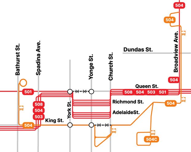
Downtown Toronto streetcar map showing all Queen and King streetcars funneled onto (from west to east) Queen, York, Richmond & Adelaide, Church, and Queen again, while King street from Spadina to Broadview is served by replacement buses.
Significant streetcar diversions through downtown May-August will disrupt busiest surface transit route in Canada.
Poor line management by TTC and lack of modern switches and transit signal priority means this detour will delay riders and make surface transit less […]
[Original post on mstdn.ca]
05.05.2025 11:42 — 👍 0 🔁 2 💬 1 📌 0
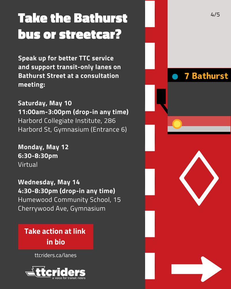
graphic titled: "Take the Bathurst bus or streetcar?"
Text content is same as in corresponding tweet
Do you take the Bathurst bus or streetcar? Speak at a consultation:
Saturday May 10, 11am-3pm, Harbord Collegiate Institute, 286 Harbord St, Gymnasium
Monday, May 12, 6:30-8:30pm, Virtual
Wednesday, May 14, 4:30-8:30pm, Humewood Community School, 15 Cherrywood Ave, Gymnasium
02.05.2025 00:46 — 👍 10 🔁 8 💬 2 📌 1
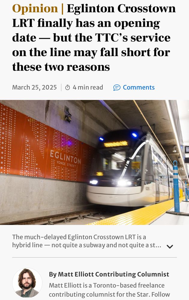
Screenshot of linked article headline:
Eglinton Crosstown LRT finally has an opening date — but the TTC's service
on the line may fall short for these two reasons.
Underneath the headline is a photo of a light rail vehicle in an Eglinton Crosstown underground station. Under that, a photo of the author Matt Elliott and his bio blurb.
In the Star, @GraphicMatt on risks to Eglinton Crosstown success:
“Together, these two failures — poor route management and bad or non-existent transit priority — could easily spell disaster for the Eglinton LRT once it starts service. I hope I’m wrong. Especially […]
[Original post on mstdn.ca]
25.03.2025 11:07 — 👍 0 🔁 2 💬 0 📌 0
Screenshot of linked Toronto Star article, showing the headline quoted in the post, and a photo of a streetcar which is derailed on a sunny winter day. The photo is taken from about 25m ahead of the streetcar, at ground level, so snow is blurry in the foreground and we can't see the streetcar's wheels or the rails.
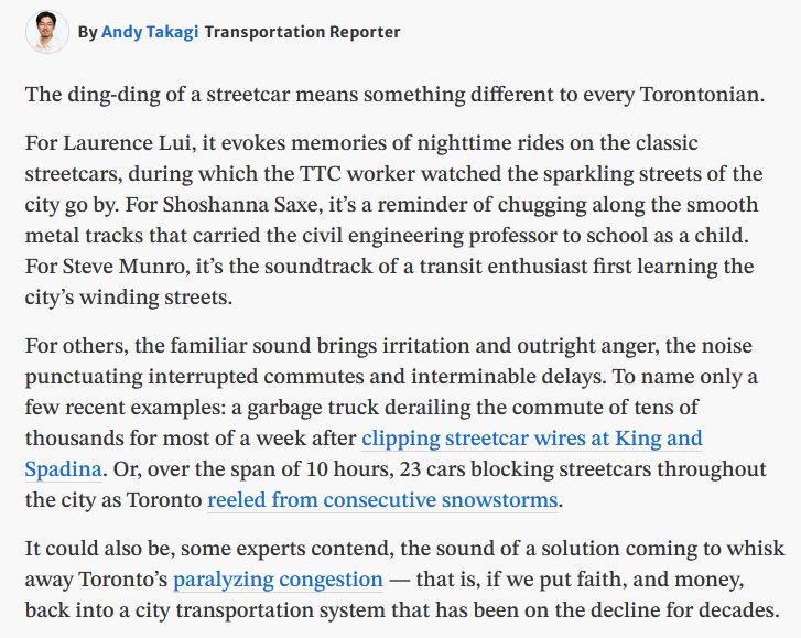
By Andy TakagiTransportation Reporter
The ding-ding of a streetcar means something different to every Torontonian.
For Laurence Lui, it evokes memories of nighttime rides on the classic streetcars, during which the TTC worker watched the sparkling streets of the city go by. For Shoshanna Saxe, it’s a reminder of chugging along the smooth metal tracks that carried the civil engineering professor to school as a child. For Steve Munro, it’s the soundtrack of a transit enthusiast first learning the city’s winding streets.
For others, the familiar sound brings irritation and outright anger, the noise punctuating interrupted commutes and interminable delays. To name only a few recent examples: a garbage truck derailing the commute of tens of thousands for most of a week after clipping streetcar wires at King and Spadina. Or, over the span of 10 hours, 23 cars blocking streetcars throughout the city as Toronto reeled from consecutive snowstorms.
It could also be, some experts contend, the sound of a solution coming to whisk away Toronto’s paralyzing congestion — that is, if we put faith, and money, back into a city transportation system that has been on the decline for decades.
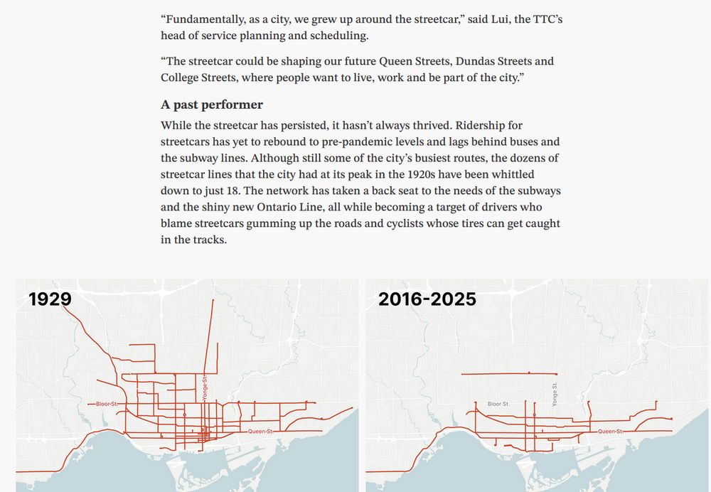
Article excerpt followed by two maps of the streetcar network. The 1929 map shows a huge network of red lines across Toronto, while the map of 2016-2025 is far more limited. The excerpt reads:
“Fundamentally, as a city, we grew up around the streetcar,” said Lui, the TTC’s head of service planning and scheduling.
“The streetcar could be shaping our future Queen Streets, Dundas Streets and College Streets, where people want to live, work and be part of the city.”
A past performer
While the streetcar has persisted, it hasn’t always thrived. Ridership for streetcars has yet to rebound to pre-pandemic levels and lags behind buses and the subway lines. Although still some of the city’s busiest routes, the dozens of streetcar lines that the city had at its peak in the 1920s have been whittled down to just 18. The network has taken a back seat to the needs of the subways and the shiny new Ontario Line, all while becoming a target of drivers who blame streetcars gumming up the roads and cyclists whose tires can get caught in the tracks.
“Streetcars carry more people, more consistently, faster, more evenly. It feels better,” Saxe said. “Getting rid of the streetcar is just talking about making the city smaller (and) worse.”
Lui agreed, emphasizing the important role the streetcar continues to play as part of the city’s transit network.
“If one streetcar is carrying close to 200 people when it’s full, imagine if that was four or five buses and what that would mean in terms of congestion levels,” Lui said.
In the short term, the city’s transit solutions lie in the realm of buses and bike lanes, Saxe said — “things that we can do this decade to make (transit) better.”
That longer-term future includes LRTs, which depending on who you ask, is essentially the same as a streetcar. (Others argue that LRTs have distinct features, like right-of-ways and more distance between stops.) On top of the long-awaited — and long-delayed — Eglinton Crosstown and Finch West LRTs, the city has plans for Eglinton East and Waterfront East LRT, both of which remain in the design stage without long-term funding.
The problem, as with most services in the city, is money, Lui said. With the TTC’s existing streetcar fleet, he explained, the city could run five-minute service throughout Toronto — if it had the money to pay drivers.
All the while, the streetcar is one of the TTC’s most profitable modes of transit.
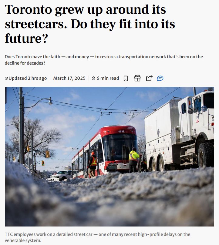
Toronto Star feature article on the history and potential of Toronto's streetcar network.
"Toronto grew up around its streetcars. Do they fit into its future? Does Toronto have the faith — and money — to restore a transportation network that’s been on the decline […]
[Original post on mstdn.ca]
17.03.2025 19:55 — 👍 2 🔁 3 💬 0 📌 0
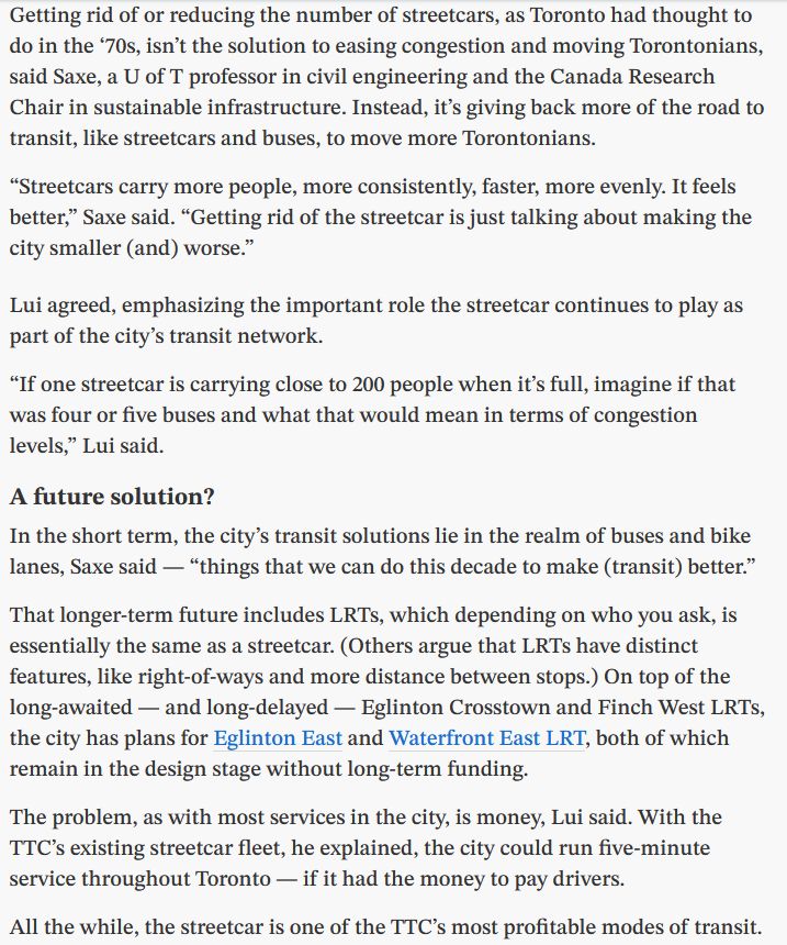
Screenshot of linked video showing young boy in front of TTC buses, pointing at his book titled "Have you seen a TTC bus?"
Front cover of Luis-Mario Carrington's book, "Have you seen a TTC bus?" which features a large photo of a TTC bus on route 65 Parliament.
"Meet this 11-year-old boy who is an expert in all things TTC" - CP24 https://www.youtube.com/watch?v=9kwKAjeEB2s
You can buy Luis-Mario Carrington's book about TTC buses from CodeRedTO and transit supporter Spacing […]
[Original post on mstdn.ca]
14.03.2025 17:43 — 👍 0 🔁 3 💬 0 📌 0
Screenshot of Toronto Star headline over image of a Crosstown LRV
“After 13 years, sources close to the Eglinton Crosstown LRT project say the long-awaited line is finally expected to welcome transit riders in September.” - Toronto Star […]
[Original post on mstdn.ca]
13.03.2025 22:08 — 👍 0 🔁 0 💬 2 📌 1
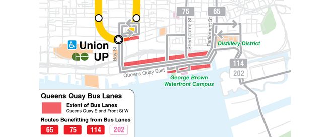
TTC route map showing the eastern harbourfront from around the SkyDome to Cherry Beach. Existing bus routes are shown, and the section of Queen’s Quay East which would gain bus lanes is highlighted. The routes which would benefit from the bus lanes are 65, 75, 114, and 202.
The TTC has plans to install bus-only lanes along Queens Quay East and Front Street to get buses out of traffic congestion. New bus lanes would reduce travel times by 30% and could be rolled out in May 2025 if approved - but will need your support!
Fill out the […]
[Original post on mstdn.ca]
17.02.2025 22:28 — 👍 6 🔁 3 💬 1 📌 0
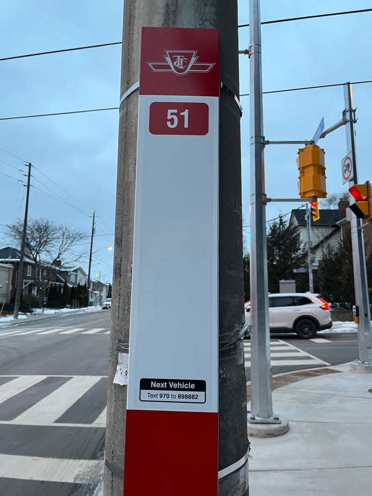
TTC bus stop sign with route 51 listed.
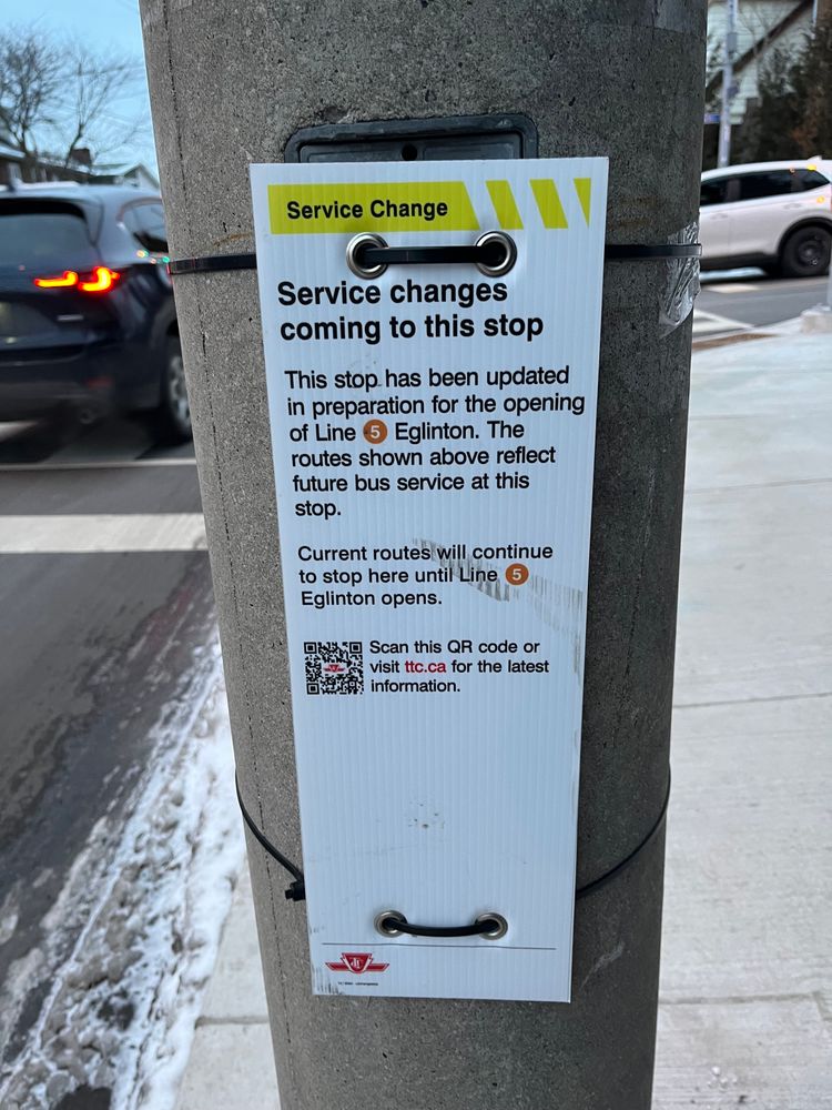
Temporary TTC sign attached to telephone pole which reads:
Service Change
Service changes
coming to this stop
This stop has been updated
in preparation for the opening
of Line 5 Eglinton. The
routes shown above reflect
future bus service at this
stop.
Current routes will continue
to stop here until Line
Eglinton opens.
Scan this QR code or
visit ttc.ca for the latest
information.
10 / 1-1
Updated bus route signage beginning to appear around Toronto to prepare for the opening of Line 5, surprisingly early given lack of government communication.
In an interesting wayfinding choice, in this location only the future route number is listed, not the […]
[Original post on mstdn.ca]
15.01.2025 02:14 — 👍 0 🔁 2 💬 1 📌 0
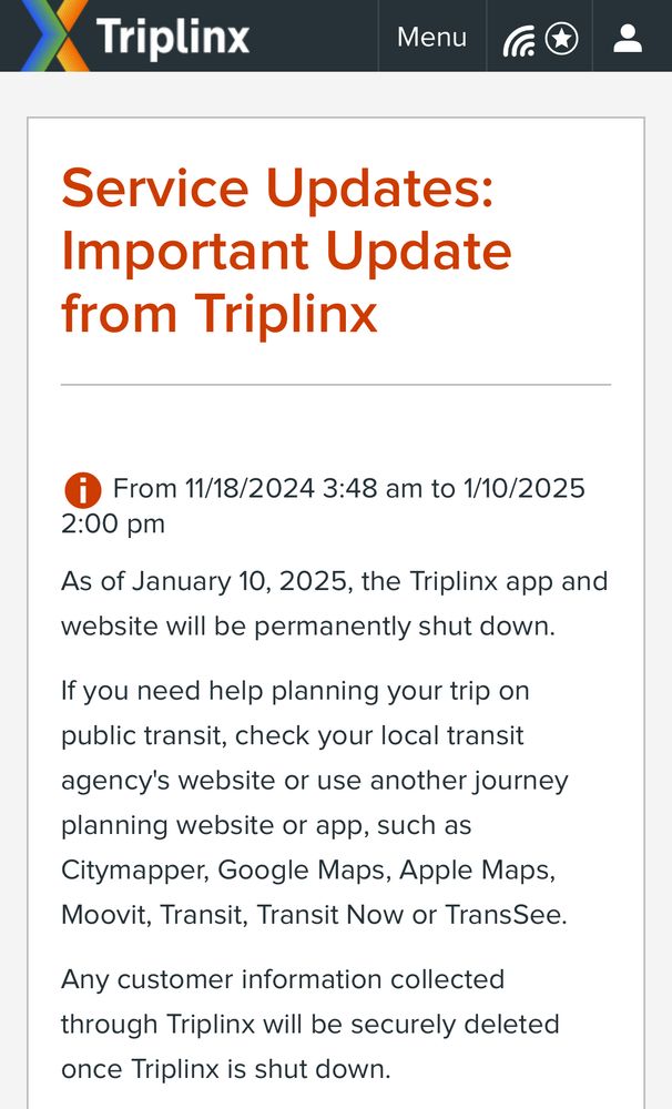
Screenshot of notice at linked website, which reads:
Important Update
from Triplinx
As of January 10, 2025, the Triplinx app and
website will be permanently shut down.
If you need help planning your trip on
public transit, check your local transit
agency's website or use another journey
planning website or app, such as
Citymapper, Google Maps, Apple Maps,
Moovit, Transit, Transit Now or TransSee.
Any customer information collected
through Triplinx will be securely deleted
once Triplinx is shut down.
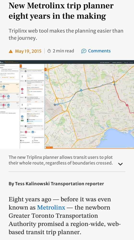
Screenshot of Toronto Star article heralding the arrival of trip planning website triplinx.ca in 2015
GTHA Transit Trip Planning: Metrolinx is quietly shutting down their centralized trip planning Triplinx.ca website and app on January 10, 2025.
Transit riders seeking trip planning are now directed to individual agency websites, or private sector offerings for […]
[Original post on mstdn.ca]
02.01.2025 01:27 — 👍 2 🔁 1 💬 0 📌 0
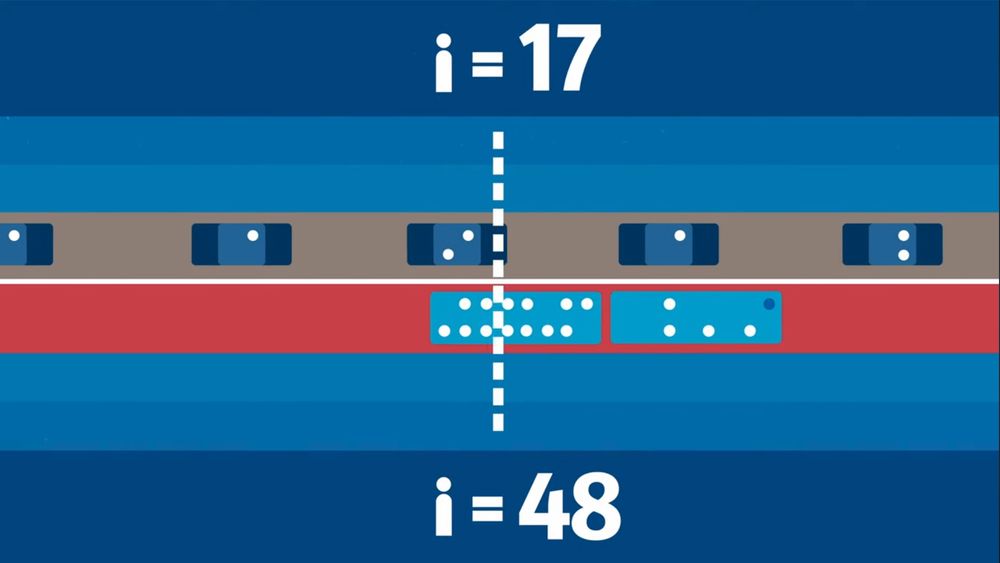
An illustration of a two lane roadway, with private cars containing 1-2 people in one lane, and a dedicated red bus lane carrying only buses with 25+ passengers each. A counter is displayed for each lane, showing how the crowded car lane only has allowed through 17 people so far, while the allegedly empty bus lane has allowed through 48.
This is an excellent short video from BC Translink showing how dedicated transit lanes move more people than mixed traffic lanes, allowing those who have an option to choose transit.
This same concept applies to dedicated space for active transportation like […]
[Original post on mstdn.ca]
23.12.2024 13:18 — 👍 1 🔁 2 💬 0 📌 0