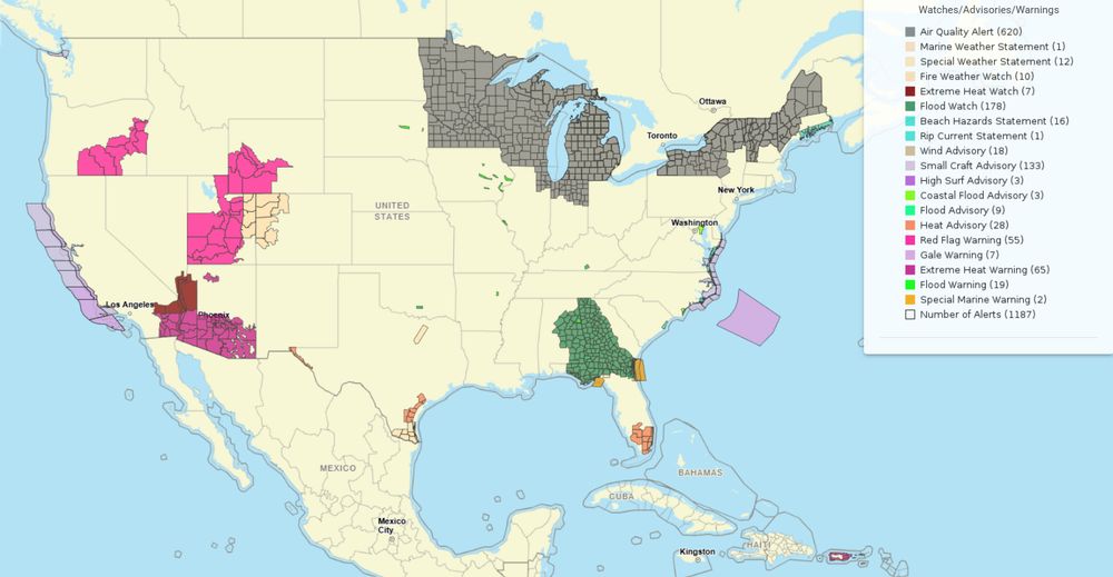
Active weather map highlights air quality concerns in the upper Midwest and Northeast, extreme heat and wildfire risks in the 4-Corners region and central Great Basin, with Red Flag Warnings in Hawaii. Heavy rain and flash flood potential in the Southeast. Visit Weather.gov.
03.08.2025 18:16 — 👍 113 🔁 18 💬 5 📌 5
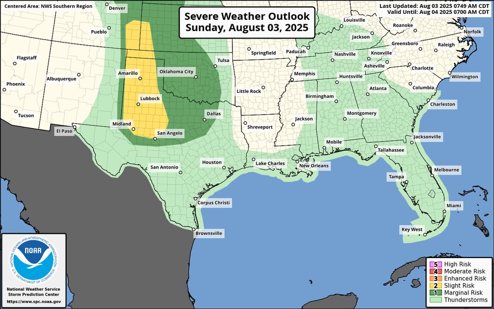
A Severe Weather Outlook map for Sunday, August 03, 2025, shows a widespread area of "Slight Risk" (level 2) for severe weather across the Southern U.S., from Texas to the Carolinas and Florida. A more significant "Enhanced Risk" (level 3) is focused on the Texas and Oklahoma panhandles, with a small "Moderate Risk" (level 4) zone within that area in the northern Texas Panhandle.
Large to very large hail and damaging winds will be possible this afternoon and evening over parts of the central/southern High Plains. Additional strong to severe storms are probable in the Northwest during the afternoon. Visit weather.gov for the latest in your area.
03.08.2025 15:21 — 👍 87 🔁 26 💬 2 📌 1
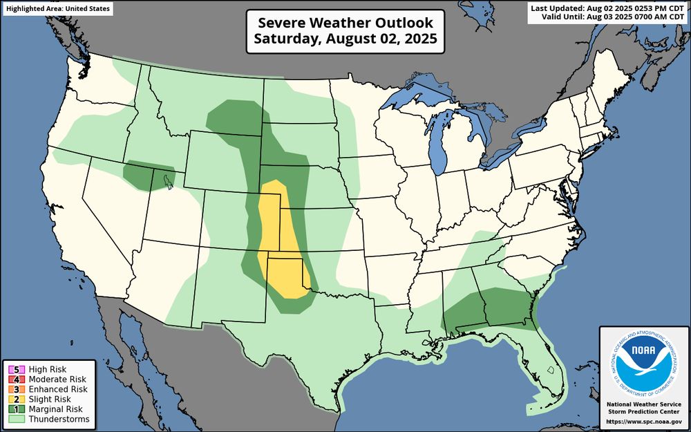
A U.S. map showing a severe weather outlook for Saturday, August 2, 2025. A 'slight risk' (level 2 of 5) of severe weather is shown in a broad area that includes much of the central and southern High Plains, extending from portions of western South Dakota down through western Nebraska, eastern Colorado, western Kansas, the Texas Panhandle, and central Oklahoma. A smaller, separate area of 'slight risk' is also shown across southern Georgia, southern Alabama, and the Florida Panhandle.
Scattered severe thunderstorms are possible in parts of the central and southern High Plains late this afternoon into tonight. Large to very large hail and severe wind gusts (60-80 mph) are the primary threats. Visit weather.gov for your local forecast.
02.08.2025 20:50 — 👍 95 🔁 20 💬 1 📌 1
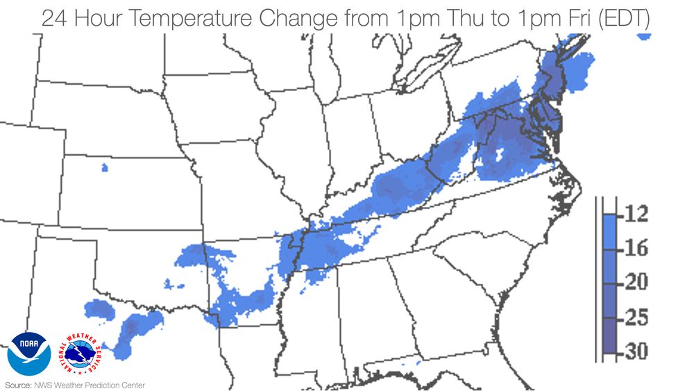
Map showing 24-hour temperature drops from 1pm Thursday to 1pm Friday (EDT), with the largest decreases (up to 30°F) in the central Appalachians and Mid-Atlantic
There was a big temperature swing for a large part of the eastern U.S. over the last 24 hours behind a cold front. Blues highlight the biggest swings, including Washington/Dulles Airport which was 92°F yesterday at 1pm and only 69°F today. Visit weather.gov for your weekend.
01.08.2025 19:12 — 👍 122 🔁 20 💬 8 📌 2
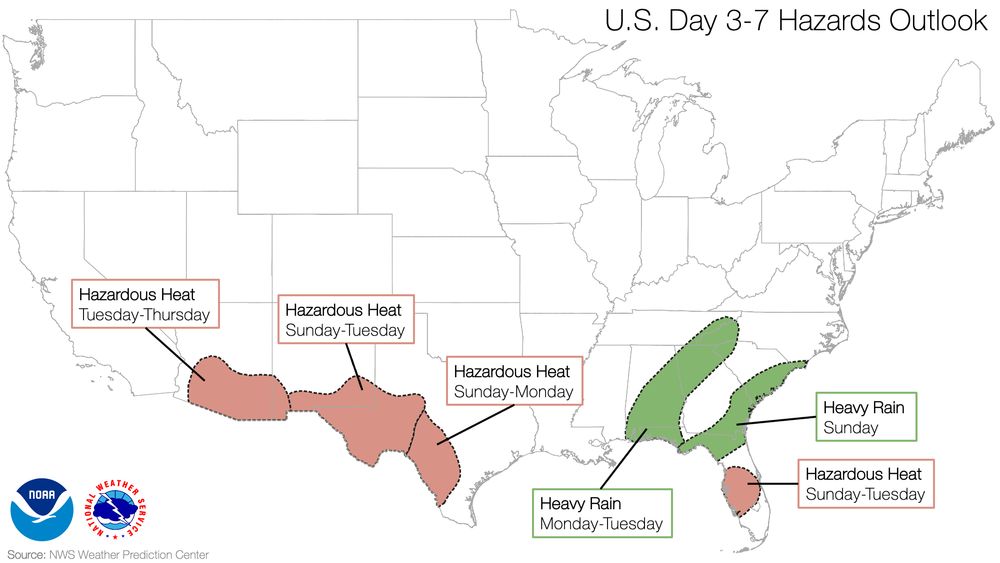
Map showing U.S. hazards outlook for Days 3–7, highlighting areas of hazardous heat across the Southwest, southern Plains, Gulf Coast, and central Florida, and heavy rain across parts of the Southeast.
As parts of the U.S. Southwest, far southern Plains, and central Florida see more hazardous heat next week, a stalled frontal system will bring the potential for heavy rain to the Southeast Sunday through Tuesday. You can always get your latest, local weather forecast updates at weather.gov.
01.08.2025 17:27 — 👍 72 🔁 17 💬 2 📌 2
The view from our GOES East satellite at sunrise revealed widespread wildfire smoke that is resulting in large areas of unhealthy air quality, and Air Quality Alerts for at least portions of eight U.S. states. Take precautions. Learn how at weather.gov/safety/airquality
01.08.2025 14:21 — 👍 1207 🔁 335 💬 48 📌 20
Scattered strong to severe storms are possible across parts of the High Plains this afternoon/evening, and isolated severe storms capable of large hail and severe wind gusts are expected in the High Plains on Saturday.
If you're planning outdoor activities, also plan on where to shelter in a storm.
01.08.2025 14:06 — 👍 64 🔁 13 💬 1 📌 1
Thunderstorms and heavy rainfall are expected to bring the potential for flooding across the Carolinas, Southern Plains, and the front-range of the Rockies on Friday. Fire weather concerns will persist in the northwestern Great Basin. Air quality will continue to be impacted in the Midwest.
01.08.2025 00:26 — 👍 130 🔁 20 💬 6 📌 5
🚨🚗 Kids & pets die in hot cars every year. Temps can hit 140°F in minutes! Partnering with Herndon, VA Police, we urge: Look before you lock. Save a life! heat.gov #CheckTheBackSeat #BeatTheHeat
31.07.2025 22:03 — 👍 100 🔁 20 💬 2 📌 2
On Tuesday, an 8.8 magnitude #earthquake struck off the coast of Russia, triggering multiple #tsunami alerts along the U.S. west coast. Learn how NOAA scientists monitor, detect, and research tsunamis: noaa.gov/explainers/science-behind-tsunamis
31.07.2025 16:23 — 👍 290 🔁 98 💬 8 📌 12
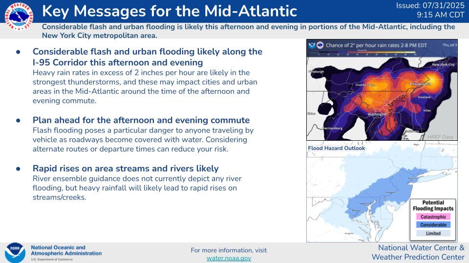
The National Water Center has issued updated Key Messages for the Mid-Atlantic, including the I-95 Corridor. More info: water.noaa.gov
31.07.2025 14:25 — 👍 80 🔁 22 💬 2 📌 7
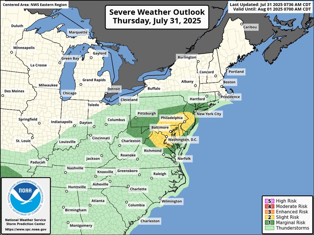
Slight risk of severe storms from Washington, D.C. to southern Pennsylvania and New Jersey. Marginal risk stretches across the Mid-Atlantic and Southeast.
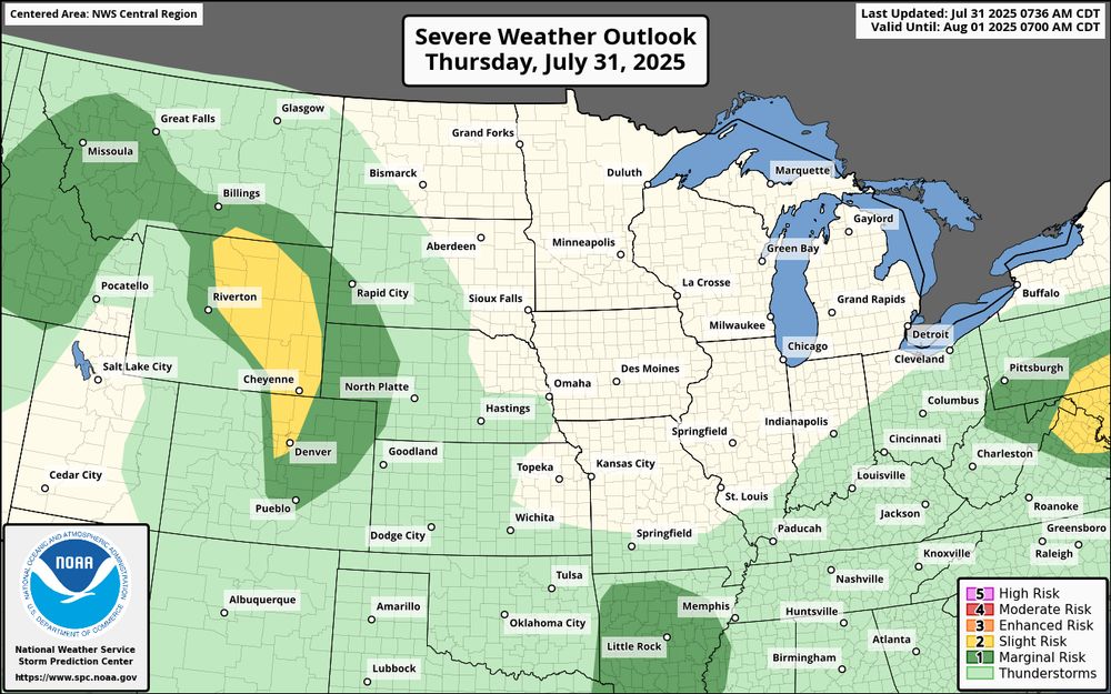
Slight risk of severe storms in parts of Wyoming, Colorado, and western Nebraska. Marginal risk extends from Utah to Missouri and into the Northern Plains.
A few severe storms capable of damaging winds are possible this afternoon across the Mid-Atlantic region. Other severe wind and hail producing storms are also possible across the central/northern High Plains. Visit weather.gov for the latest, local forecast.
31.07.2025 13:53 — 👍 115 🔁 20 💬 3 📌 2
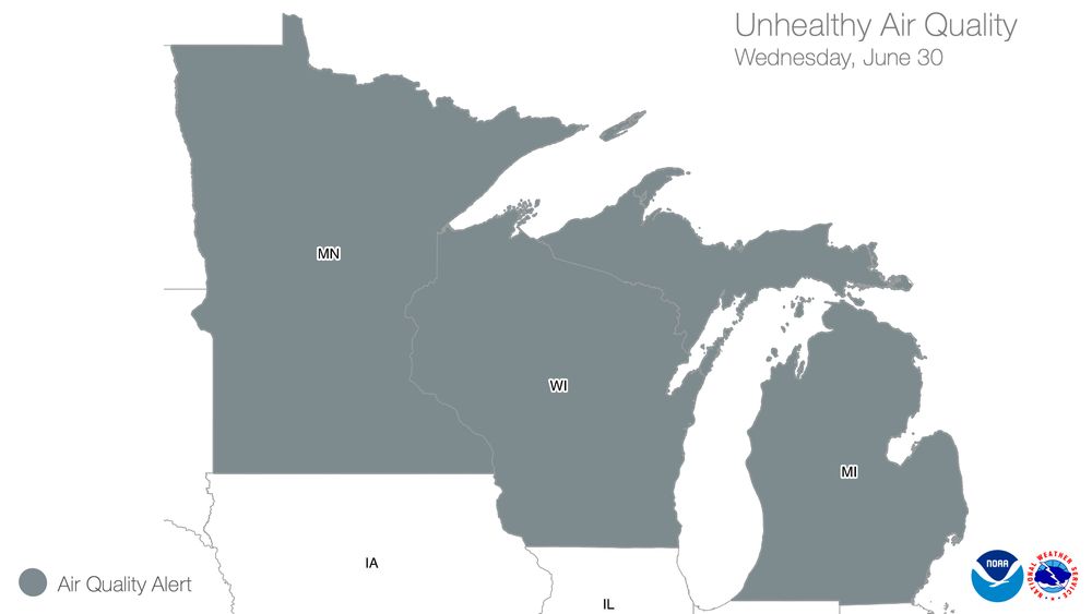
Map showing air quality alerts for Wednesday, June 30, with unhealthy air quality across Minnesota, Wisconsin, and Michigan.
Northerly winds will continue to transport smoke from wildfires south into Minnesota, Wisconsin, and Michigan today. Sensitive groups, such as people with lung disease, heart disease, and children and older adults, may experience health effects. Learn more: weather.gov/safety/airquality
30.07.2025 18:49 — 👍 86 🔁 20 💬 1 📌 2
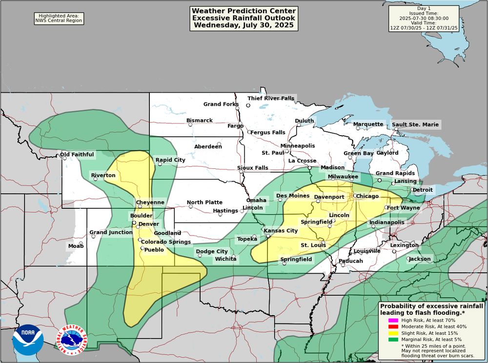
Map showing the Weather Prediction Center's excessive rainfall outlook for July 30, 2025, with slight (yellow) and marginal (green) risk areas for flash flooding across parts of the Central U.S., including Colorado, Missouri, and Illinois.
Monsoonal thunderstorms producing heavy rainfall and the potential for flash flooding is expected across New Mexico into the Rockies today. Recently burned areas will be most susceptible to flash flooding. Strong thunderstorms may also bring a flooding threat to the Mid-Mississippi Valley today.
30.07.2025 14:49 — 👍 140 🔁 32 💬 1 📌 5
🚗☀️ NEVER leave kids or pets in a hot car—it can hit 140°F in seconds! Always check the back seat to save a life. heat.gov #CheckTheBackSeat
30.07.2025 11:03 — 👍 193 🔁 38 💬 1 📌 2

U.S. Tsunami Warning Centers
TSUNAMI WARNING 3: See tsunami.gov for alert areas. M8.7 080mi SE Petropavlovsk, Kamchatka 1625PDT Jul 29
30.07.2025 01:36 — 👍 178 🔁 103 💬 7 📌 18
U.S. Tsunami Warning Centers
As of 8:25 PM EDT July 29, 2025: Please visit tsunami.gov for the latest updates on expanding watches, warnings and advisories across the Pacific and western U.S.
30.07.2025 00:29 — 👍 217 🔁 147 💬 1 📌 32

U.S. Tsunami Warning Centers
TSUNAMI ADVISORY 1: See tsunami.gov for alert areas. M8.0 080mi SE Petropavlovsk, Kamchatka 1625PDT Jul 29
30.07.2025 00:00 — 👍 154 🔁 74 💬 3 📌 14
🌡️🚨 A dangerous heat wave is ongoing across the central & eastern U.S.! Heat is the #1 weather killer. Stay safe: wear light clothing, stay in shade, hydrate, & NEVER leave kids/pets in cars. Visit heat.gov!
29.07.2025 19:00 — 👍 209 🔁 53 💬 4 📌 6
GOES West captured von Kármán vortices streaming around Guadalupe Island this morning. These cloud formations typically occur when the prevailing wind is diverted by elevated land features such as islands, mountaintops, or volcanoes. More cloud science at: noaa.gov/jetstream/clouds
29.07.2025 18:02 — 👍 195 🔁 32 💬 2 📌 6
Though relief is on the horizon, HeatRisk will still be in the Major and Extreme category for the next few days for broad swaths of the eastern portions of the nation. If you're not inside in AC, make sure to hydrate well and take frequent breaks in the shade. Heat illness can sneak up on you.
29.07.2025 17:09 — 👍 199 🔁 44 💬 1 📌 10
Happy 67th Birthday to NOAA and NWS partner NASA! At NWS, the Space Weather Prediction Center works hand-in-hand with NASA to understand and prepare for space weather events, like solar radiation storms.
29.07.2025 16:03 — 👍 243 🔁 42 💬 3 📌 5
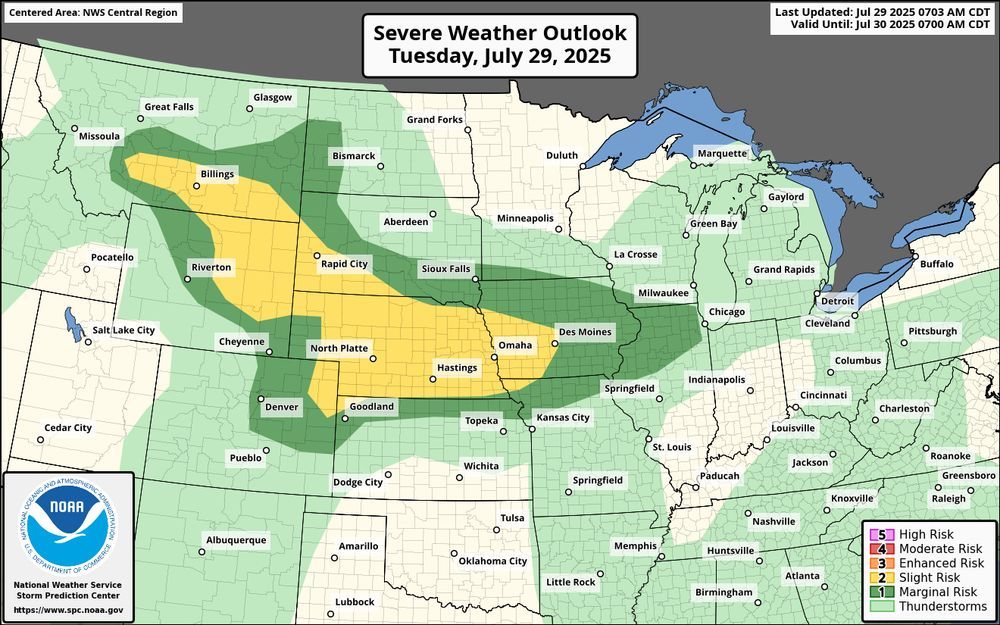
Severe weather outlook for Tuesday, July 29, 2025, showing a slight risk (yellow) from eastern Montana through Nebraska to western Iowa. Marginal risk (dark green) surrounds this area, with general thunderstorms (light green) expected across much of the central and eastern U.S.
Today: Severe thunderstorms are expected from southern Montana into the central High Plains, and across much of Nebraska and western Iowa. Areas of damaging winds will be possible, with hail most likely over western areas. Visit weather.gov for the latest.
29.07.2025 13:32 — 👍 128 🔁 13 💬 1 📌 4
Image of the NWS logo. Cloud with a lightning bolt and the lettering "National Weather Service"
NWS is hiring! The first of several top-priority, mission-critical positions posted Friday on USAJobs.gov! Others will follow soon. Visit USAJobs.gov and search “NWS” to learn more.
28.07.2025 17:37 — 👍 210 🔁 80 💬 12 📌 12
Clouds are science in action! Interested in learning more about weather and the science behind it? Visit Jetstream, the NWS online weather school! weather.gov/jetstream
28.07.2025 15:32 — 👍 456 🔁 54 💬 7 📌 14
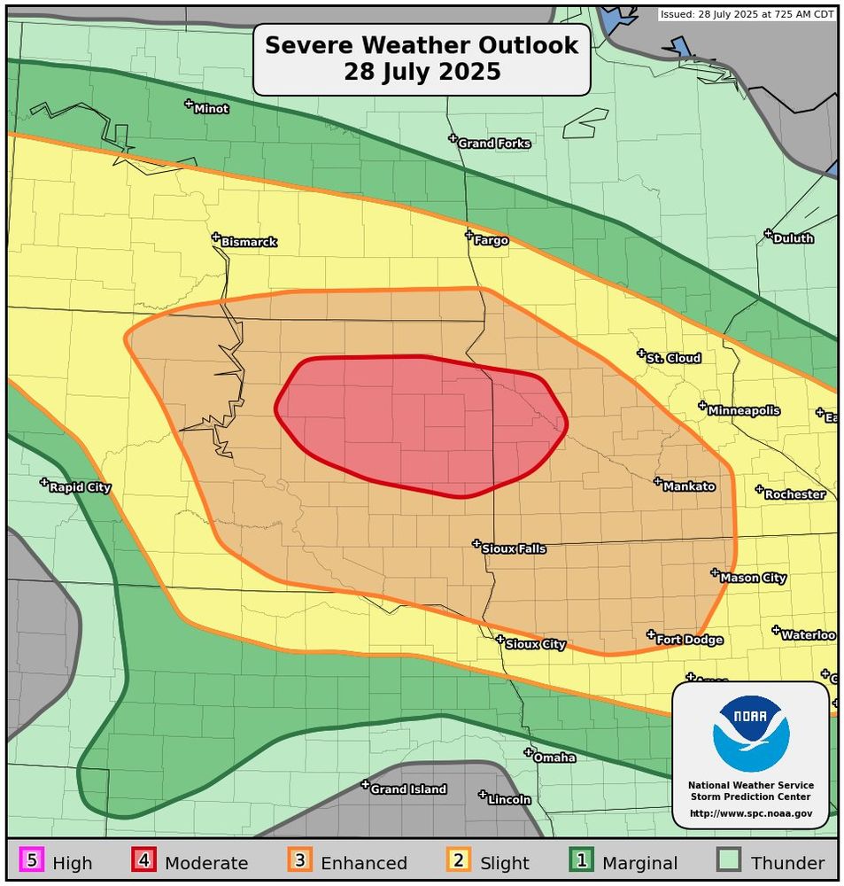
Severe Weather Outlook - July 28, 2025
Map showing the severe weather outlook across the Norther Plains and Upper Mississippi River Valley. The highest risk areas, the Moderate Risk (red, 4 out of 5) and Enhanced Risk (orange, 3 out of 5) are located across South Dakota, far southern North Dakota, Minnesota, and Iowa.
⚠️Severe storms expected this Afternoon & Tonight...
* LOCATIONS...
Eastern South Dakota
Southwest Minnesota
Northwest Iowa
* HAZARDS...
Widespread damaging winds, some hurricane force
A couple of tornadoes
Isolated large hail
More: spc.noaa.gov/products/out...
28.07.2025 15:12 — 👍 201 🔁 52 💬 2 📌 9
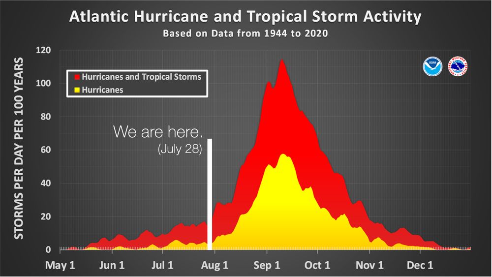
Chart showing average Atlantic hurricane and tropical storm activity from May to December based on data from 1944 to 2020. Activity increases sharply in August, peaking in mid-September. A marker indicates the current date as July 28, just before activity begins to rise.
On average, 86% of all named tropical systems in the Atlantic occur after August 2, and the first hurricane doesn't form until August 11.
We have a long season to go. Prepare now – Learn how at weather.gov/safety/hurricane
28.07.2025 11:27 — 👍 1271 🔁 329 💬 67 📌 78