GRR issues Area Forecast Discussion (AFD) at Aug 13, 7:45 PM EDT
at Wed, 13 Aug 2025 23:46:28 +0000 via IEMbot
Additional Details Here.
14.08.2025 00:06 — 👍 0 🔁 0 💬 0 📌 0
HOLLAND Aug 13
Climate Report:
High: None
Low: None
Precip: 0.0"
Snow: Missing
at Wed, 13 Aug 2025 21:28:58 +0000 via IEMbot
Additional Details Here.
13.08.2025 21:46 — 👍 0 🔁 0 💬 0 📌 0
GRAND RAPIDS Aug 13
Climate Report:
High: 85
Low: 69
Precip: 0.0"
Snow: 0.0" Snow Depth: 0"
at Wed, 13 Aug 2025 21:28:58 +0000 via IEMbot
Additional Details Here.
13.08.2025 21:46 — 👍 1 🔁 0 💬 0 📌 0
GRR issues Area Forecast Discussion (AFD) at Aug 13, 3:12 PM EDT
at Wed, 13 Aug 2025 19:12:19 +0000 via IEMbot
Additional Details Here.
13.08.2025 19:26 — 👍 0 🔁 0 💬 0 📌 0
GRR issues Area Forecast Discussion (AFD) at Aug 13, 1:42 PM EDT
at Wed, 13 Aug 2025 17:43:03 +0000 via IEMbot
Additional Details Here.
13.08.2025 17:46 — 👍 0 🔁 0 💬 0 📌 0
GRR issues Public Information Statement (PNS) at Aug 13, 9:00 AM EDT ...PRECIPITATION REPORTS... via IEMbot
Additional Details Here.
13.08.2025 13:06 — 👍 0 🔁 0 💬 0 📌 0
GRR issues Area Forecast Discussion (AFD) at Aug 13, 7:41 AM EDT
at Wed, 13 Aug 2025 11:42:03 +0000 via IEMbot
Additional Details Here.
13.08.2025 11:46 — 👍 0 🔁 0 💬 0 📌 0
GRR issues Area Forecast Discussion (AFD) at Aug 13, 3:48 AM EDT
at Wed, 13 Aug 2025 07:48:37 +0000 via IEMbot
Additional Details Here.
13.08.2025 08:06 — 👍 0 🔁 0 💬 0 📌 0
BATTLE CREEK Aug 12
Climate Report:
High: 88
Low: 68
Precip: 3.73"
Snow: Missing
at Wed, 13 Aug 2025 06:47:36 +0000 via IEMbot
Additional Details Here.
13.08.2025 07:06 — 👍 0 🔁 0 💬 0 📌 0
KALAMAZOO Aug 12
Climate Report:
High: 87
Low: 69
Precip: 1.2"
Snow: 0.0" Snow Depth: 0"
at Wed, 13 Aug 2025 06:47:36 +0000 via IEMbot
Additional Details Here.
13.08.2025 07:06 — 👍 0 🔁 0 💬 0 📌 0
GRR issues Area Forecast Discussion (AFD) at Aug 13, 1:53 AM EDT
at Wed, 13 Aug 2025 05:53:30 +0000 via IEMbot
Additional Details Here.
13.08.2025 06:06 — 👍 0 🔁 0 💬 0 📌 0
GRR cancels Flood Warning for Calhoun, Kalamazoo [MI]
at Wed, 13 Aug 2025 03:52:00 +0000 via IEMbot
Additional Details Here.
13.08.2025 04:06 — 👍 0 🔁 0 💬 0 📌 0
GRR issues Summary Local Storm Report
at Wed, 13 Aug 2025 02:34:17 +0000 via IEMbot
Additional Details Here.
13.08.2025 02:46 — 👍 0 🔁 0 💬 0 📌 0
GRR issues Hazardous Weather Outlook (HWO) at Aug 12, 10:14 PM EDT
at Wed, 13 Aug 2025 02:15:47 +0000 via IEMbot
Additional Details Here.
13.08.2025 02:26 — 👍 0 🔁 0 💬 0 📌 0
GRR cancels Flood Advisory for Barry [MI]
at Wed, 13 Aug 2025 01:38:27 +0000 via IEMbot
Additional Details Here.
13.08.2025 01:46 — 👍 0 🔁 0 💬 0 📌 0
GRR cancels Flood Advisory for Kent, Ottawa [MI]
at Wed, 13 Aug 2025 00:48:33 +0000 via IEMbot
Additional Details Here.
13.08.2025 01:06 — 👍 0 🔁 0 💬 0 📌 0
GRR expires Severe Thunderstorm Warning for Calhoun [MI]
at Tue, 12 Aug 2025 23:52:26 +0000 via IEMbot
Additional Details Here.
13.08.2025 00:06 — 👍 0 🔁 0 💬 0 📌 0
Hastings [Barry Co, MI] CO-OP Observer reports Rain of 2.35 Inch at 12 Aug, 8:00 PM EDT -- Total since 4 PM.
at Wed, 13 Aug 2025 00:03:32 +0000 via IEMbot
Additional Details Here.
13.08.2025 00:06 — 👍 0 🔁 0 💬 0 📌 0
GRR issues Area Forecast Discussion (AFD) at Aug 12, 7:26 PM EDT
at Tue, 12 Aug 2025 23:26:55 +0000 via IEMbot
Additional Details Here.
12.08.2025 23:46 — 👍 0 🔁 0 💬 0 📌 0
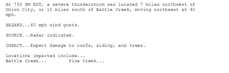
At 730 PM EDT, a severe thunderstorm was located 7 miles northwest of
Union City, or 10 miles south of Battle Creek, moving northeast at 40
mph.
HAZARD...60 mph wind gusts.
SOURCE...Radar indicated.
IMPACT...Expect damage to roofs, siding, and trees.
Locations impacted include...
Battle Creek... Pine Creek...
🚨 Severe Thunderstorm Warning issued August 12 at 7:30PM EDT until August 12 at 8:00PM EDT by NWS Grand Rapids MI 🚨
Additional Details Here.
12.08.2025 23:45 — 👍 0 🔁 0 💬 0 📌 0
GRR issues Severe Thunderstorm Warning [tornado: POSSIBLE, wind: 60 MPH (RADAR INDICATED), hail: <.75 IN (RADAR INDICATED)] for Calhoun, Kalamazoo [MI] till 8:00 PM EDT
at Tue,... at Tue, 12 Aug 2025 23:08:33 +0000 via IEMbot
Additional Details Here.
12.08.2025 23:26 — 👍 0 🔁 0 💬 0 📌 0
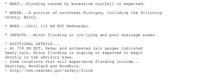
* WHAT...Flooding caused by excessive rainfall is expected.
* WHERE...A portion of southwest Michigan, including the following
county, Barry.
* WHEN...Until 115 AM EDT Wednesday.
* IMPACTS...Minor flooding in low-lying and poor drainage areas.
* ADDITIONAL DETAILS...
- At 708 PM EDT, Radar and automated rain gauges indicated
heavy rain. Minor flooding is ongoing or expected to begin
shortly in the advisory area.
- Some locations that will experience flooding include...
Hastings, Woodland and Woodbury.
- http://www.weather.gov/safety/flood
Flood Advisory issued August 12 at 7:08PM EDT until August 13 at 1:15AM EDT by NWS Grand Rapids MI
Additional Details Here.
12.08.2025 23:15 — 👍 0 🔁 0 💬 0 📌 0
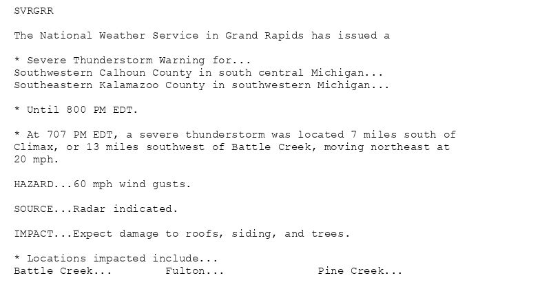
SVRGRR
The National Weather Service in Grand Rapids has issued a
* Severe Thunderstorm Warning for...
Southwestern Calhoun County in south central Michigan...
Southeastern Kalamazoo County in southwestern Michigan...
* Until 800 PM EDT.
* At 707 PM EDT, a severe thunderstorm was located 7 miles south of
Climax, or 13 miles southwest of Battle Creek, moving northeast at
20 mph.
HAZARD...60 mph wind gusts.
SOURCE...Radar indicated.
IMPACT...Expect damage to roofs, siding, and trees.
* Locations impacted include...
Battle Creek... Fulton... Pine Creek...
🚨 Severe Thunderstorm Warning issued August 12 at 7:08PM EDT until August 12 at 8:00PM EDT by NWS Grand Rapids MI 🚨
Additional Details Here.
12.08.2025 23:15 — 👍 0 🔁 0 💬 0 📌 0
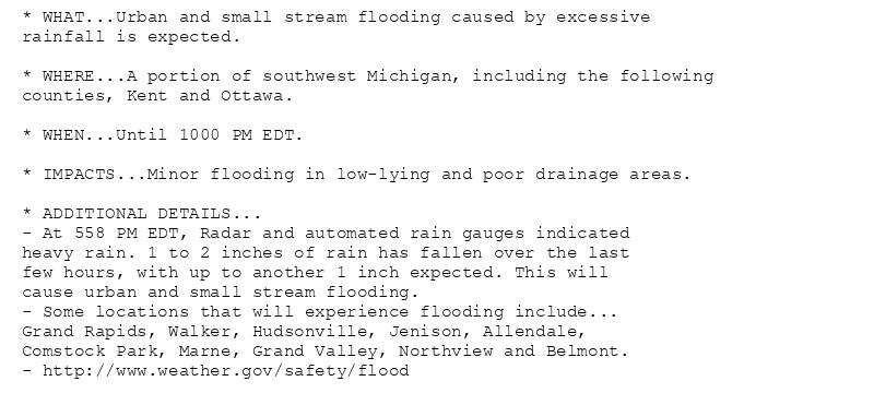
* WHAT...Urban and small stream flooding caused by excessive
rainfall is expected.
* WHERE...A portion of southwest Michigan, including the following
counties, Kent and Ottawa.
* WHEN...Until 1000 PM EDT.
* IMPACTS...Minor flooding in low-lying and poor drainage areas.
* ADDITIONAL DETAILS...
- At 558 PM EDT, Radar and automated rain gauges indicated
heavy rain. 1 to 2 inches of rain has fallen over the last
few hours, with up to another 1 inch expected. This will
cause urban and small stream flooding.
- Some locations that will experience flooding include...
Grand Rapids, Walker, Hudsonville, Jenison, Allendale,
Comstock Park, Marne, Grand Valley, Northview and Belmont.
- http://www.weather.gov/safety/flood
Flood Advisory issued August 12 at 5:58PM EDT until August 12 at 10:00PM EDT by NWS Grand Rapids MI
Additional Details Here.
12.08.2025 22:15 — 👍 0 🔁 0 💬 0 📌 0
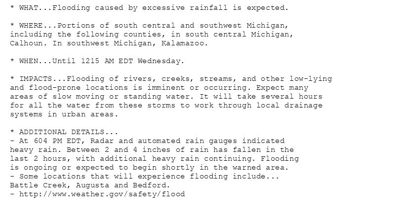
* WHAT...Flooding caused by excessive rainfall is expected.
* WHERE...Portions of south central and southwest Michigan,
including the following counties, in south central Michigan,
Calhoun. In southwest Michigan, Kalamazoo.
* WHEN...Until 1215 AM EDT Wednesday.
* IMPACTS...Flooding of rivers, creeks, streams, and other low-lying
and flood-prone locations is imminent or occurring. Expect many
areas of slow moving or standing water. It will take several hours
for all the water from these storms to work through local drainage
systems in urban areas.
* ADDITIONAL DETAILS...
- At 604 PM EDT, Radar and automated rain gauges indicated
heavy rain. Between 2 and 4 inches of rain has fallen in the
last 2 hours, with additional heavy rain continuing. Flooding
is ongoing or expected to begin shortly in the warned area.
- Some locations that will experience flooding include...
Battle Creek, Augusta and Bedford.
- http://www.weather.gov/safety/flood
🚨 Flood Warning issued August 12 at 6:05PM EDT until August 13 at 12:15AM EDT by NWS Grand Rapids MI 🚨
Additional Details Here.
12.08.2025 22:15 — 👍 0 🔁 0 💬 0 📌 0
GRR issues Flood Advisory for Kent, Ottawa [MI] till Aug 12, 10:00 PM EDT
at Tue, 12 Aug 2025 21:59:01 +0000 via IEMbot
Additional Details Here.
12.08.2025 22:06 — 👍 0 🔁 0 💬 0 📌 0
BATTLE CREEK Aug 12
Climate Report:
High: 88
Low: 70
Precip: 0.04"
Snow: Missing
at Tue, 12 Aug 2025 21:34:46 +0000 via IEMbot
Additional Details Here.
12.08.2025 21:46 — 👍 0 🔁 0 💬 0 📌 0
KALAMAZOO Aug 12
Climate Report:
High: 87
Low: 69
Precip: 0.12"
Snow: 0.0" Snow Depth: 0"
at Tue, 12 Aug 2025 21:34:46 +0000 via IEMbot
Additional Details Here.
12.08.2025 21:46 — 👍 0 🔁 0 💬 0 📌 0
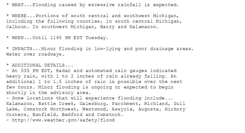
* WHAT...Flooding caused by excessive rainfall is expected.
* WHERE...Portions of south central and southwest Michigan,
including the following counties, in south central Michigan,
Calhoun. In southwest Michigan, Barry and Kalamazoo.
* WHEN...Until 1145 PM EDT Tuesday.
* IMPACTS...Minor flooding in low-lying and poor drainage areas.
Water over roadways.
* ADDITIONAL DETAILS...
- At 535 PM EDT, Radar and automated rain gauges indicated
heavy rain, with 1 to 2 inches of rain already falling. An
additional 1 to 1.5 inches of rain is possible over the next
few hours. Minor flooding is ongoing or expected to begin
shortly in the advisory area.
- Some locations that will experience flooding include...
Kalamazoo, Battle Creek, Galesburg, Parchment, Richland, Gull
Lake, Comstock Northwest, Westwood, Assyria, Augusta, Hickory
Corners, Banfield, Bedford and Comstock.
- http://www.weather.gov/safety/flood
Flood Advisory issued August 12 at 5:37PM EDT until August 12 at 11:45PM EDT by NWS Grand Rapids MI
Additional Details Here.
12.08.2025 21:45 — 👍 0 🔁 0 💬 0 📌 0
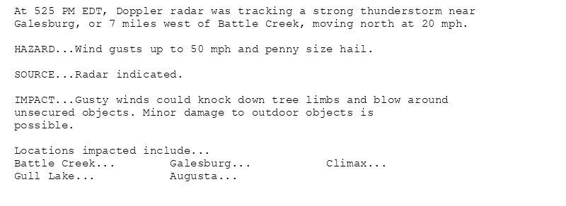
At 525 PM EDT, Doppler radar was tracking a strong thunderstorm near
Galesburg, or 7 miles west of Battle Creek, moving north at 20 mph.
HAZARD...Wind gusts up to 50 mph and penny size hail.
SOURCE...Radar indicated.
IMPACT...Gusty winds could knock down tree limbs and blow around
unsecured objects. Minor damage to outdoor objects is
possible.
Locations impacted include...
Battle Creek... Galesburg... Climax...
Gull Lake... Augusta...
Special Weather Statement issued August 12 at 5:25PM EDT by NWS Grand Rapids MI
Additional Details Here.
12.08.2025 21:30 — 👍 0 🔁 0 💬 0 📌 0