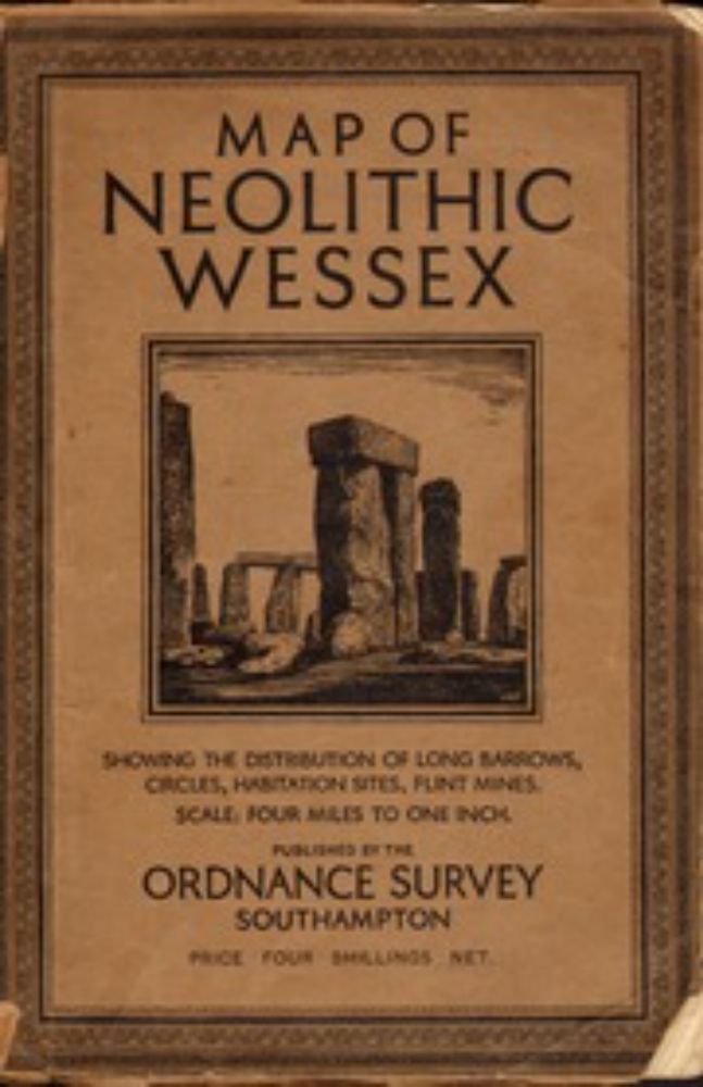
2/2 The map and gazetteer listing the sites numbered on the map can be viewed on archive org here: archive.org/details/Neol...
26.05.2025 10:59 — 👍 1 🔁 0 💬 0 📌 0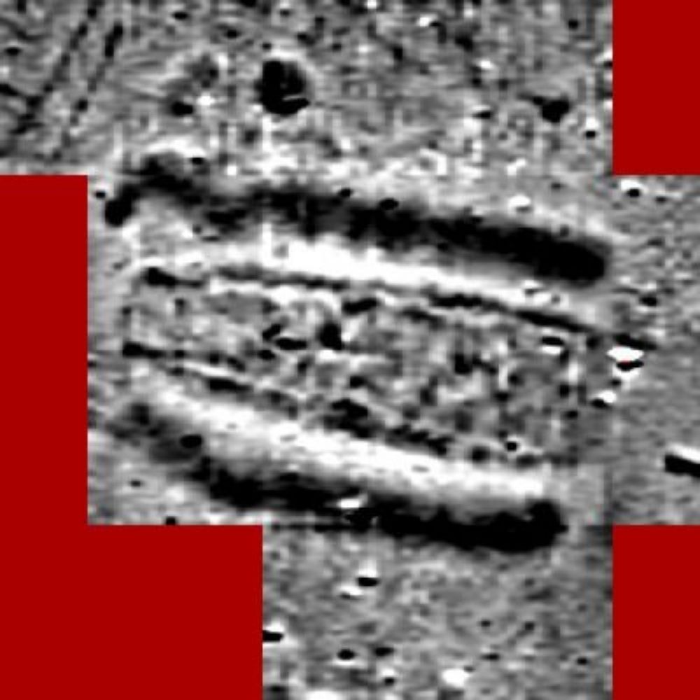
@mikegill.bsky.social
Archaeology, Neolithic, long barrows, landscape, GIS, geophysics. Community archaeology. Everton fan. Visiting Fellow Bournemouth University.
2/2 The map and gazetteer listing the sites numbered on the map can be viewed on archive org here: archive.org/details/Neol...
26.05.2025 10:59 — 👍 1 🔁 0 💬 0 📌 0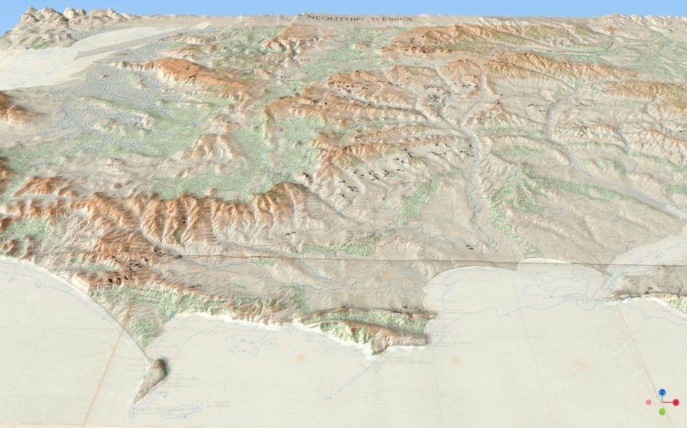
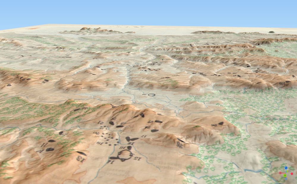
For #MapMonday, here is the fantastic Ordnance Survey 1932 Map of Neolithic Wessex in 3D. I've uploaded a copy of the model to #Sketchfab so anyone can zoom in and out, spin the map around etc: skfb.ly/pxySs. #Archaeology #OrdnanceSurvey #Neolithic #Wessex 1/2
26.05.2025 10:59 — 👍 6 🔁 3 💬 1 📌 0
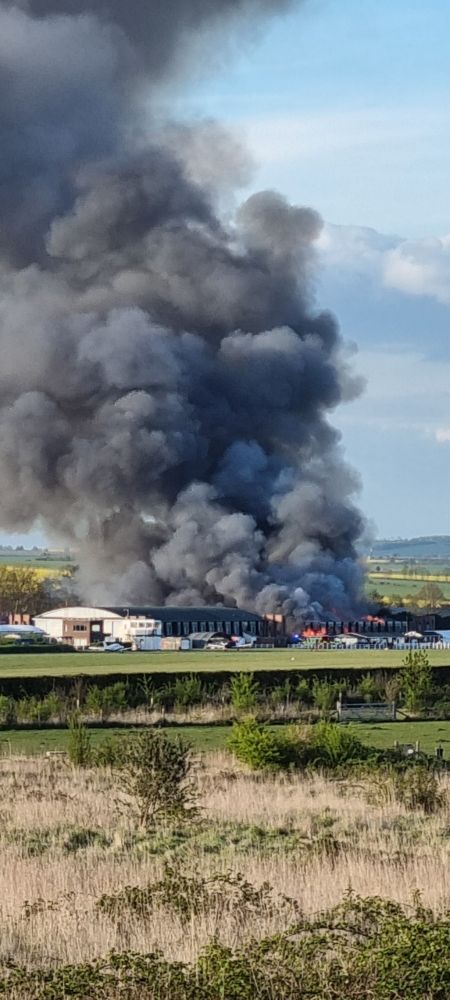
Big fire at Old Sarum #Salisbury now
17.04.2025 18:07 — 👍 2 🔁 1 💬 0 📌 0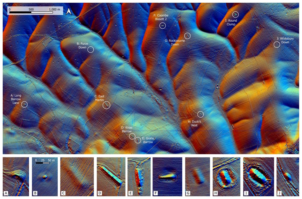
Lidar map of long barrows north east of the village of Martin, Hampshire
Here is a #Lidar map of the #Neolithic long barrows north-east of the village of Martin #Hampshire, up on Cranborne Chase. The insets are all at the same scale and allow a comparison of the extant mounds, which are diverse in shape and size. #Archaeology
02.03.2025 21:37 — 👍 9 🔁 2 💬 0 📌 0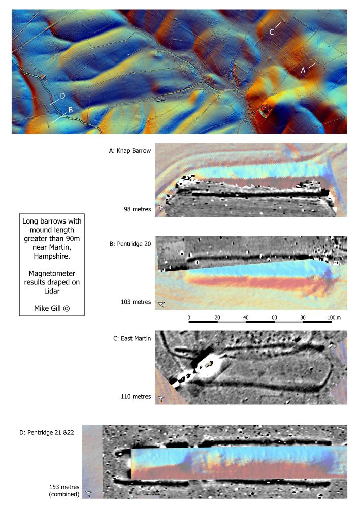
Magnetometer surveys of Neolithic long barrows near Martin. Results plotted on Lidar visualisations of the mounds.
There are some very 'long' #Neolithic long barrows on Cranborne Chase near Martin, #Hampshire. Buried ditches shown in magnetometer survey results, draped on #Lidar. #Archaeology #TombTuesday
03.02.2025 20:33 — 👍 12 🔁 0 💬 0 📌 0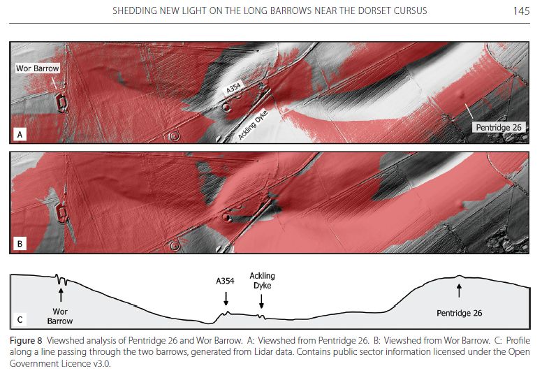
5/5 Pentridge 26 not only shares a similar morphology to Wor Barrow. Each are intervisible across a chalk valley, and act as local horizon features when viewed from each other. Discussed in Gill 2021 'Shedding new light on the long barrows near the Dorset Cursus' Dorset DNHAS Proceedings 142.
31.01.2025 17:28 — 👍 1 🔁 0 💬 0 📌 0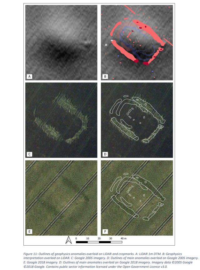
4/5 The survey results for Pentridge 26 can be compared with cropmarks and the LiDAR representation of the ploughed out mound ...
31.01.2025 17:28 — 👍 2 🔁 0 💬 1 📌 0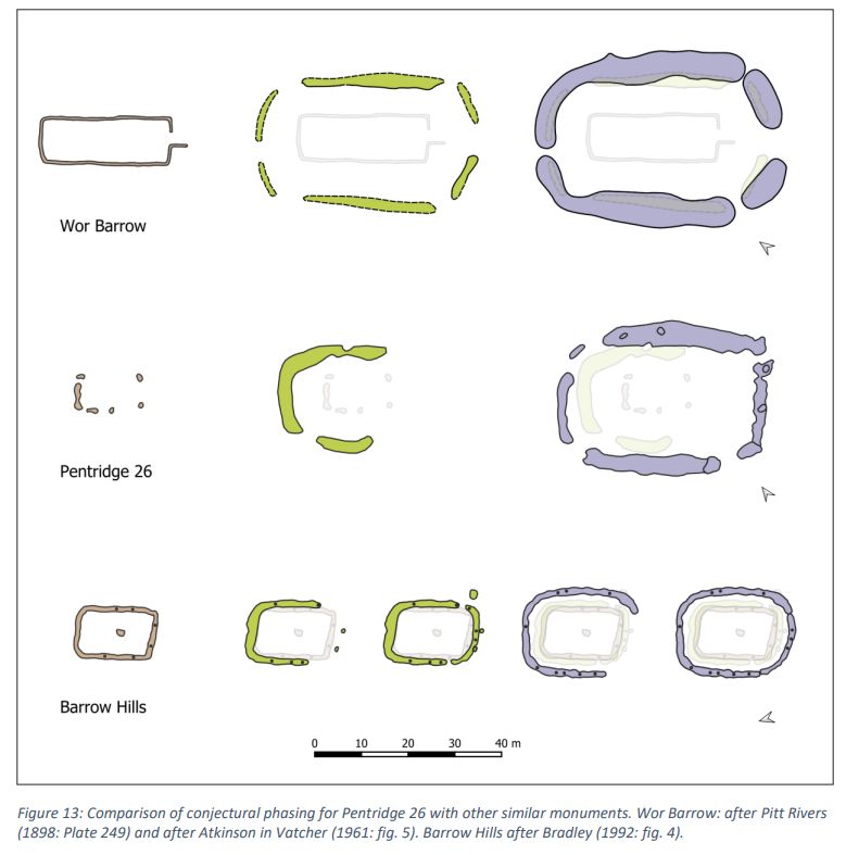
3/5 The survey of Pentridge 26 suggests it was built in a number of phases, similar to Wor Barrow and other Neolithic monuments, such as that at Barrow Hills in Oxfordshire ...
31.01.2025 17:28 — 👍 0 🔁 0 💬 1 📌 0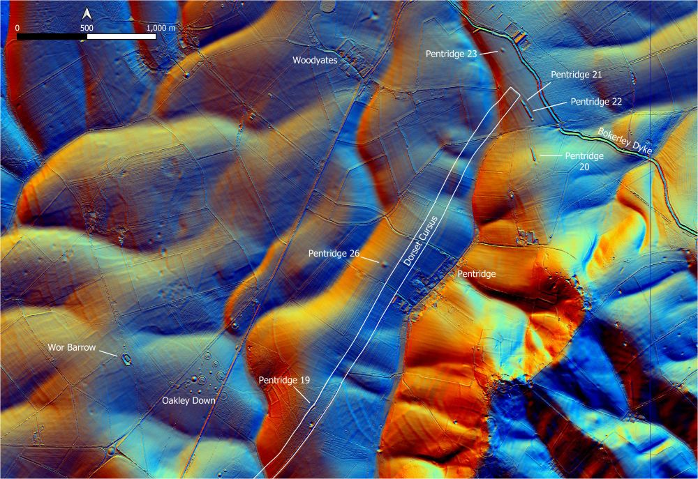
Location map of Pentridge 26
2/5 The location of Pentridge 26 can be seen in the following Lidar plot, which shows it is adjacent to the Dorset Cursus, as well as near other long barrows, including Wor Barrow, another similar long barrow that was excavated by Pitt Rivers in the 19th Century ...
31.01.2025 17:28 — 👍 0 🔁 0 💬 1 📌 0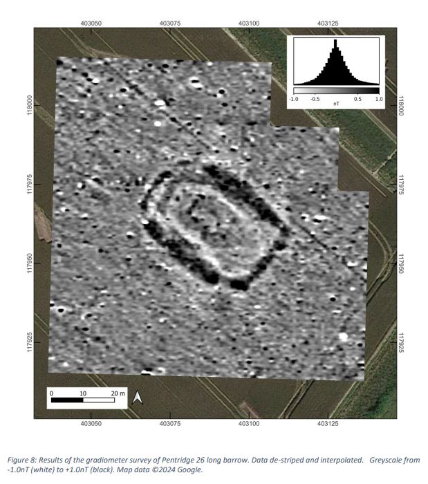
Plot of magnetometer survey of Pentridge 26 long barrow
1/5 Just finished the report for a #geophysics survey of ploughed out barrow 'Pentridge 26'. Located next to the Dorset Cursus, it is scheduled as a bowl barrow, but the survey shows it is in fact a much earlier #Neolithic long barrow. Download from: avonvalleyarchsoc.wordpress.com/reports/ ...
31.01.2025 17:28 — 👍 3 🔁 0 💬 1 📌 0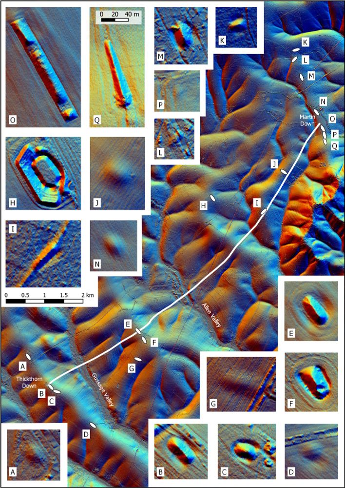
Lidar map of the Dorset Cursus with insets showing long barrow mounds
A quick #Lidar map showing the positions of #Neolithic long barrows near the Dorset Cursus, with the long barrows shown as insets. #Archaeology
11.12.2024 22:33 — 👍 36 🔁 9 💬 0 📌 1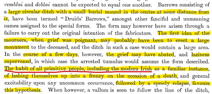
Outrageous comments from Pitt Rivers in Excavations in Cranborne Chase v4 p145, re disc barrows. "The habit of all primitive people, including the modern Irish... of lashing themselves up into a frenzy on the occasion of a death ... followed by a speedy relapse, favours this hypothesis" #Archaeology
26.11.2024 21:56 — 👍 3 🔁 0 💬 1 📌 0
🌟⭐️GIVE AWAY ⭐️🌟
Get your hands on a copy of the 2nd Edition of my book 'Cumbria's Prehistoric Monuments.
🌟⭐️🌟⭐️🌟⭐️🌟
TO ENTER, LIKE AND REPOST THIS POST!! 🤩
[A winner will be randomly selected a week from now! Good luck!]
#archaeology #StandingStoneSunday #giveaway
Just in case it wasn't seen the first time, reposting this for #HillfortsWednesday 🙂
20.11.2024 09:56 — 👍 12 🔁 2 💬 0 📌 0
Geophysics results draped on a 3D plot of a long barrow
I've been out surveying around a #Neolithic long barrow with AVAS this weekend. The results are superb, particularly as we were using an old Geoscan single sensor FM36, kindly loaned by Bournemouth University via the LoCATE project. Surveyed under a Section 42 licence. #Archaeology #Geophysics
17.11.2024 17:21 — 👍 15 🔁 2 💬 0 📌 0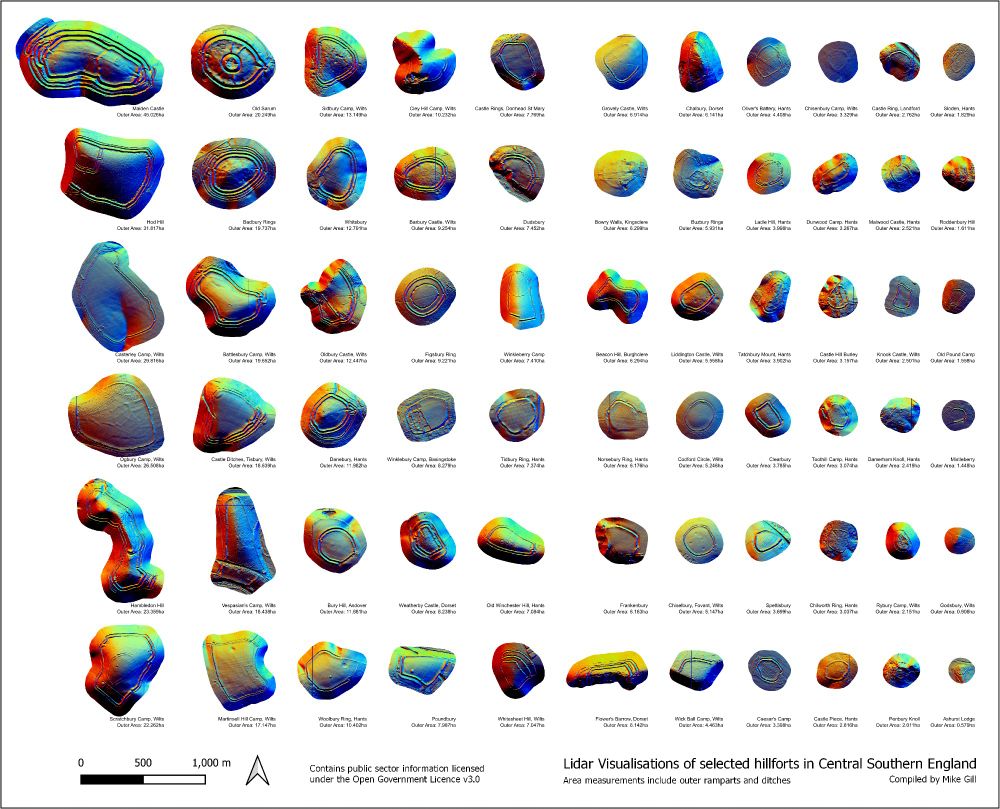
Picture of 66 Lidar snippets showing hillforts in central Southern England
Just made the jump from X! To test the water, I am posting some #LiDAR snippets of #hillforts from central southern England. This image was my most popular post on X, let's see how many views and followers I can get on here 🙂. #Archaeology
15.11.2024 16:12 — 👍 73 🔁 11 💬 3 📌 1