
The current active gale pattern across the Atlantic is making for a challenging start for trans-Atlantic voyages from the W'rn Mediterranean. Contact WRI for an updated forecast!
13.11.2025 22:06 — 👍 0 🔁 0 💬 0 📌 0
@weatherrouting.bsky.social
Weather Routing provides customized forecasts and routing guidance for marine clients worldwide
The current active gale pattern across the Atlantic is making for a challenging start for trans-Atlantic voyages from the W'rn Mediterranean. Contact WRI for an updated forecast!
13.11.2025 22:06 — 👍 0 🔁 0 💬 0 📌 0
Set sail with confidence! WRI's prepaid forecast packages offer discounted rates and flexibility as they never expire- you can roll over what's left to use for future trips. Contact WRI for pricing and more info!
09.11.2025 03:45 — 👍 0 🔁 0 💬 0 📌 0
The last day of FLIBS is today from 10am-5pm. Meteorologists Alex Avalos and Cara Czech will be at both Oasis Lounge locations, Bahia Mar and Superyacht Village. Complimentary lunch and drinks are served for captain and crew here!
02.11.2025 15:22 — 👍 0 🔁 0 💬 0 📌 0
Day 1 of FLIBS is off to a rainy start! If you find yourself at the show, WRI meteorologists Alex Avalos and Cara Czech are at the Oasis Lounge and would love to have you stop by!
29.10.2025 15:44 — 👍 0 🔁 0 💬 0 📌 0

The Fort Lauderdale Boat Show is just around the corner starting on Oct 29! You can find Meteorologists Alex Avalos and Cara Czech at both Oasis Lounge locations. Reach out to WRI for any questions and forecasting assistance, see you there!
25.10.2025 17:17 — 👍 0 🔁 0 💬 0 📌 0
Will you be in Fort Lauderdale later this month? Meteorologists Alex Avalos and Cara Czech will be attending FLIBS Oct 29th-Nov 02nd! You can find us at the Oasis Lounge in the Superyacht Village and at Bahia Mar near the Swimming Hall of Fame. We'd love to see you there!

As Hurricane Humberto and Potential Tropical Cyclone 9 continue to track towards the SE'rn US, there currently remains large uncertainty with respect to the tracks and strength, particularly with 9's track once it reaches offshore South Carolina. Contact WRI for the latest!
27.09.2025 02:42 — 👍 0 🔁 0 💬 0 📌 0
The tropics are heating up quickly as the E'rn US faces a dual threat from two tropical systems! Are you looking to head down the East Coast in the near future? Contact WRI for information on the next long range window!
26.09.2025 01:43 — 👍 0 🔁 0 💬 0 📌 0
The Annapolis Boat Show is coming up! Be sure to stop by our booth, Tent K, Booth 14 where you can meet Director Jeremy Davis, and Operations Manager Brian Whitley who will be happy to discuss our services with you. The show will run from October 09-12. We hope to see you there!
23.09.2025 18:43 — 👍 0 🔁 0 💬 0 📌 0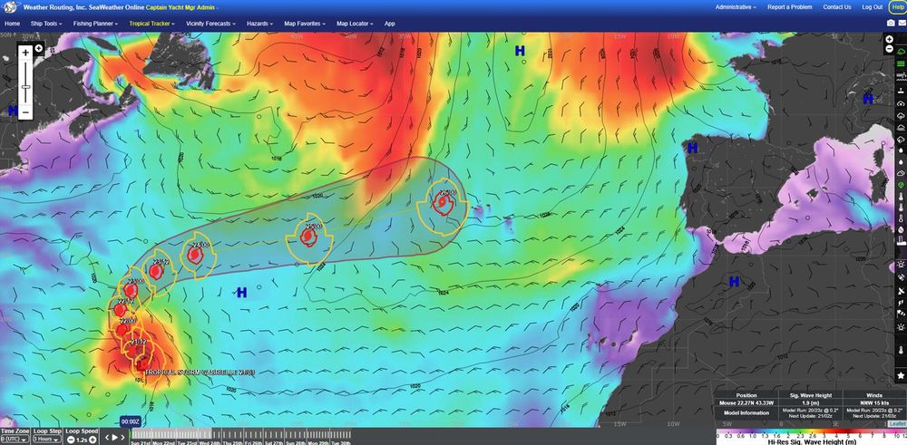
While not expected to impact any mainland areas, Tropical Storm Gabrielle's extra-tropical remnants could potentially threaten the Azores in the latter half of this week. Vessels in the Azores or heading Westbound across the N'rn Atlantic should continue to monitor this threat!
21.09.2025 02:56 — 👍 0 🔁 0 💬 0 📌 0

The latest threat to Trans-ATL crossings is currently developing Tropical Disturbance 24, and the NHC has increased its potential for development over the last few days. This system is currently becoming a better organized batch of showers/squalls. Contact WRI for the latest!
15.09.2025 03:00 — 👍 0 🔁 0 💬 0 📌 0
Are you attending this year's Newport International Boat Show? Say hello to Senior Meteorologists Kyle Petroziello and Jared Young!They're located in the same booth again this year at Corner Booth #41, Tent A, and are happy to discuss all the great services WRI has to offer!
11.09.2025 20:58 — 👍 1 🔁 0 💬 0 📌 0
Tropical Low 16 is tracking W'ward in the Atlantic basin, and further development remains possible as the system looks to approach to Windward Islands near the middle part of next week. Those with interests across the E-NE'rn Caribbean should continue to monitor this closely.
05.09.2025 22:21 — 👍 0 🔁 0 💬 0 📌 0
We'll be located in the same booth again this year at Corner Booth #41, Tent A, with branded giveaway items and flyers for new clients as well. We look forward to seeing you there!
3/3
WRI will be attending again this year, with Senior Meteorologists Kyle Petroziello and Jared Young eager to discuss our customized forecasting services with both new and longtime clients!
2/3
Do you plan on attending the 2025 Newport International Boat Show in Rhode Island from September 11th-14th?
1/3

WRI has recently designated a new Tropical Wave offshore W'rn Africa as Tropical Disturbance 23, which is currently a disorganized batch of thunderstorms. Tropical Disturbance 23 will be the next focus for vessels making Trans-Atlantic passages in the near future!
01.09.2025 16:58 — 👍 0 🔁 0 💬 0 📌 0
WRI has issued severe weather alerts for large portions of the N'rn Mediterranean Sea and S'rn Europe, as a series of cold fronts have brought persistent squall activity to the region. Contact WRI for the latest on severe weather in the Mediterranean region!
29.08.2025 17:10 — 👍 0 🔁 0 💬 0 📌 0
While the rest of the Mediterranean Sea benefits from a great late-season weather window, that is not so much the case in Greece. Persistent Etesian Troughing continues to generate strong conditions across the Cyclades and Aegean Sea. Contact WRI for routing assistance in Greece!
25.08.2025 02:55 — 👍 1 🔁 0 💬 0 📌 0
While having weakened over the past few days, Erin remains a powerful hurricane in the W'rn Atlantic. Erin will make its closest point of approach to Cape Hatteras, NC within the next 24hrs, and Tropical Storm Warnings remain in effect for much of the Outer Banks.
21.08.2025 02:36 — 👍 0 🔁 0 💬 0 📌 0

Erin remains a powerful hurricane over the N'rn Atlantic, and its residual conditions will be affecting the US East coast throughout the week. Tropical Storm Watches have already been issued for Cape Hatteras and the Outer Banks. Contact WRI for the latest tropical concerns!
19.08.2025 02:59 — 👍 0 🔁 0 💬 0 📌 0Our phone system is now working again. Thank you everyone for your patience and understanding, and we apologize for the inconvenience this has caused.
17.08.2025 14:15 — 👍 0 🔁 0 💬 0 📌 0

Erin has been upgraded to Hurricane status per the latest advisory, making it the first hurricane in the Atlantic Basin this season! Riding out the storm in the Virgin Islands? Contact WRI for the latest information and expected conditions for the region as Erin passes north!
15.08.2025 16:41 — 👍 0 🔁 0 💬 0 📌 0
As the Mediterranean Sea charter season nears its end, now is a great time to begin planning your W'bound trans-Atlantic crossing. Contact WRI for ocean-crossing assistance to avoid the tropics this season!
13.08.2025 21:56 — 👍 0 🔁 0 💬 0 📌 0
The E'rn Pacific tropics have been heating up lately as well! Tropical Storm Henriette has officially gained Post-Tropical status as it aims north of Hawaii, while newly developed Tropical Storm Ivo continues W'ward as it gains strength. Contact WRI for the latest on the tropics!
08.08.2025 23:30 — 👍 0 🔁 0 💬 0 📌 0
In the wake of Tropical Storm Dexter another disturbance has been slowly developing, and WRI has designated this as Tropical Low 09. Currently located in the Carolinas, or have a trip planned along the East Coast? Contact WRI for the latest on the Atlantic Tropics!
07.08.2025 00:08 — 👍 0 🔁 0 💬 0 📌 0
As expected the North Atlantic tropics have begun to heat up, headlined by Tropical Storm Dexter! Contact WRI for vital forecasting assistance this tropical season as we approach its peak in September!
05.08.2025 19:57 — 👍 0 🔁 0 💬 0 📌 0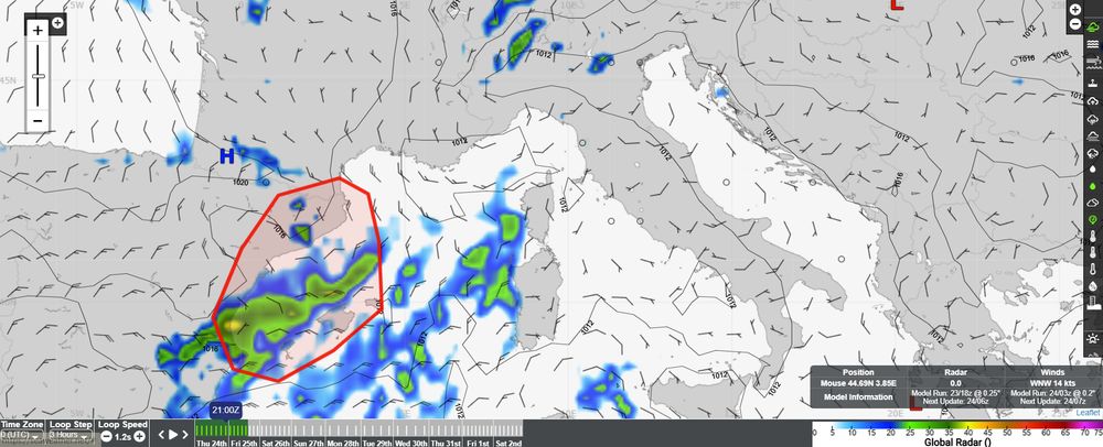

Enhanced squall activity is expected to develop across the Balearic Sea throughout the 24th, then tracking E'ward across the Mediterranean Sea through the 25th. Currently on a Mediterranean charter? Be on the lookout for severe weather alerts issued by WRI!
24.07.2025 05:51 — 👍 0 🔁 0 💬 0 📌 0

The W'rn Pacific Tropical Basin is heating up, with a strengthening tropical low expected to approach the Luzon Strait in about 24hrs. Then, the tropics remain active as the latest data suggests the development of another tropical low early next week. Contact WRI for assistance!
17.07.2025 18:06 — 👍 0 🔁 0 💬 0 📌 0
A disorganized area of widespread showers and squalls offshore NE'rn Florida has just been designated as a Tropical Disturbance. This area of concern is expected to meander W'ward over the next several days into the Gulf of Mexico. Contact WRI for the latest on the tropics!
14.07.2025 17:02 — 👍 0 🔁 0 💬 0 📌 0