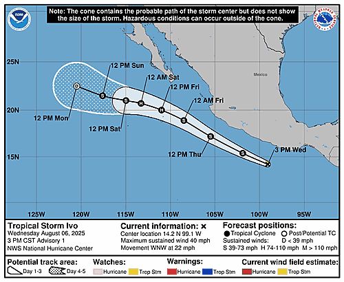
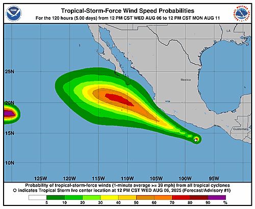
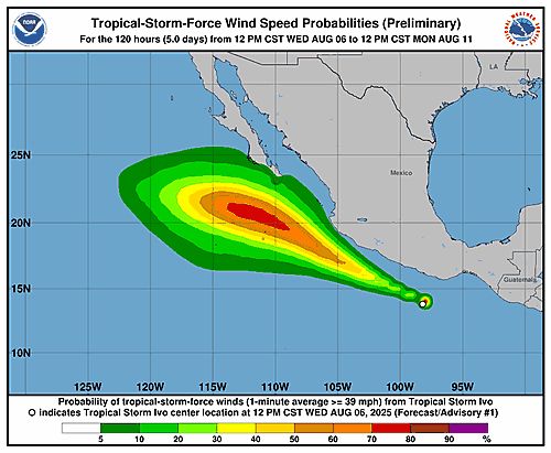
000WTPZ34 KNHC 072053TCPEP4 BULLETINTropical Storm Ivo Advisory Number 5NWS National Hurricane Center Miami FL EP092025300 PM CST Thu Aug 07 2025 ...IVO INTENSIFYING AS IT MAKES ITS CLOSEST APPROACH TO MEXICO... SUMMARY OF 300 PM CST...2100 UTC...INFORMATION----------------------------------------------LOCATION...18.8N 105.8WABOUT 410 MI...660 KM WNW OF ACAPULCO MEXICOABOUT 385 MI...625 KM SE OF THE SOUTHERN TIP OF BAJA CALIFORNIAMAXIMUM SUSTAINED WINDS...60 MPH...95 KM/HPRESENT MOVEMENT...NW OR 305 DEGREES AT 21 MPH...33 KM/HMINIMUM CENTRAL PRESSURE...1001 MB...29.56 INCHES WATCHES AND WARNINGS--------------------Interests along the coast of southwestern Mexico should continue tomonitor the progress of Ivo. DISCUSSION AND OUTLOOK----------------------At 300 PM CST (2100 UTC), the center of Tropical Storm Ivo was located near latitude 18.8 North, longitude 105.8 West. Ivo is moving toward the northwest near 21 mph (33 km/h). On the forecast track, Ivo is expected to start moving away from the coast of Mexico over the next day or so. The storm is forecast to turn more westward by the weekend. Maximum sustained winds are near 60 mph (95 km/h) with higher gusts. Strengthening is forecast for the next day or so, and Ivo could become a hurricane on Friday. Tropical-storm-force winds extend outward up to 45 miles (75 km)from the center. The estimated minimum central pressure is 1001 mb (29.56 inches). HAZARDS AFFECTING LAND----------------------RAINFALL: Tropical Storm Ivo is expected to produce storm totalrainfall of 2 to 4 inches, with isolated maximum totals of 6 inches,across portions of the Mexican states of Guerrero, Michoacan deOcampo and Colima through Friday. This would result in an elevatedrisk for flash flooding. For a complete depiction of forecast rainfall associated withTropical Storm Ivo please see the National Weather Service StormTotal Rainfall Graphic available athurricanes.gov/graphics_ep4.shtml?rainqpf SURF: Swells generated by Ivo will be affecting the southwesterncoast of Mexico during the next couple of days. These swells arelikely to cause life-threatening surf and rip current conditions.Please consult products from your local weather office. A depiction of rip current risk for the United States can be foundat: hurricanes.gov/graphics_ep4.shtml?ripCurrnets NEXT ADVISORY-------------Next complete advisory at 900 PM CST. $$Forecaster Papin
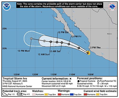
Tropical Storm Ivo 5-Day Uncertainty Track Image
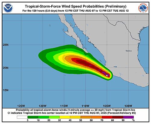
Tropical Storm Ivo 34-Knot Wind Speed Probabilities
Eastern North Pacific Tropical Storm Ivo Advisory Number 5 issued at Thu, 07 Aug 2025 20:53:56 +0000
...IVO INTENSIFYING AS IT MAKES ITS CLOSEST APPROACH TO MEXICO...
Additional Details Here.
07.08.2025 21:00 — 👍 1 🔁 0 💬 0 📌 0
065 WTPZ33 KNHC 072054TCPEP3 BULLETINTropical Storm Henriette Advisory Number 15NWS National Hurricane Center Miami FL EP0820251100 AM HST Thu Aug 07 2025 ...HENRIETTE EXPECTED TO PASS WELL TO THE NORTHEAST OF HAWAII ONSUNDAY... SUMMARY OF 1100 AM HST...2100 UTC...INFORMATION-----------------------------------------------LOCATION...18.9N 136.8WABOUT 1195 MI...1920 KM E OF HILO HAWAIIMAXIMUM SUSTAINED WINDS...45 MPH...75 KM/HPRESENT MOVEMENT...W OR 280 DEGREES AT 16 MPH...26 KM/HMINIMUM CENTRAL PRESSURE...1006 MB...29.71 INCHES WATCHES AND WARNINGS--------------------There are no coastal watches or warnings in effect. DISCUSSION AND OUTLOOK----------------------At 1100 AM HST (2100 UTC), the center of Tropical Storm Henriettewas located near latitude 18.9 North, longitude 136.8 West.Henriette is moving toward the west near 16 mph (26 km/h). Thisgeneral motion is expected to continue through today, followed by agradual turn toward the northwest Friday and over the weekend,keeping the center well to the north of the Hawaiian Islands. Maximum sustained winds have decreased to near 45 mph (75 km/h) with higher gusts. Little change in strength is forecast during the next couple of days followed by gradual intensification. Tropical-storm-force winds extend outward up to 80 miles (130 km)from the center. The estimated minimum central pressure is 1006 mb (29.71 inches). HAZARDS AFFECTING LAND----------------------None. NEXT ADVISORY-------------Next complete advisory at 500 PM HST. $$Forecaster Hagen
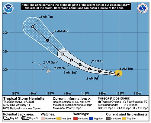
Tropical Storm Henriette 5-Day Uncertainty Track Image
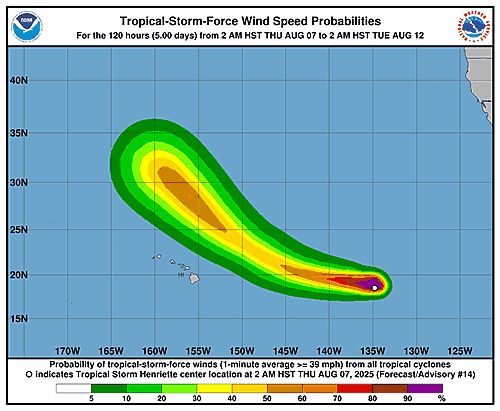
Tropical Storm Henriette 34-Knot Wind Speed Probabilities
Eastern North Pacific Tropical Storm Henriette Advisory Number 15 issued at Thu, 07 Aug 2025 20:54:54 +0000
...HENRIETTE EXPECTED TO PASS WELL TO THE NORTHEAST OF HAWAII ON SUNDAY...
Additional Details Here.
07.08.2025 21:00 — 👍 0 🔁 0 💬 0 📌 0
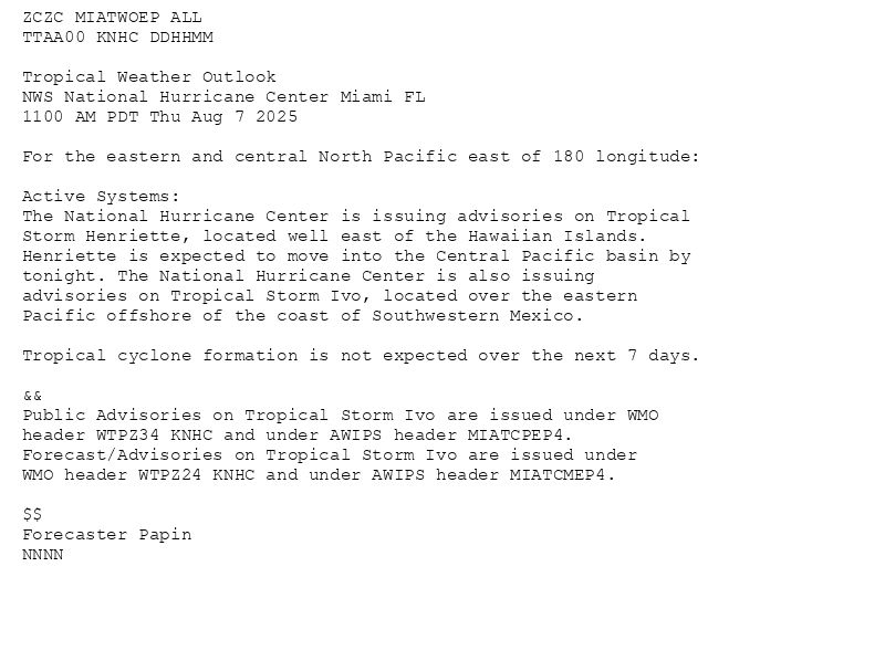
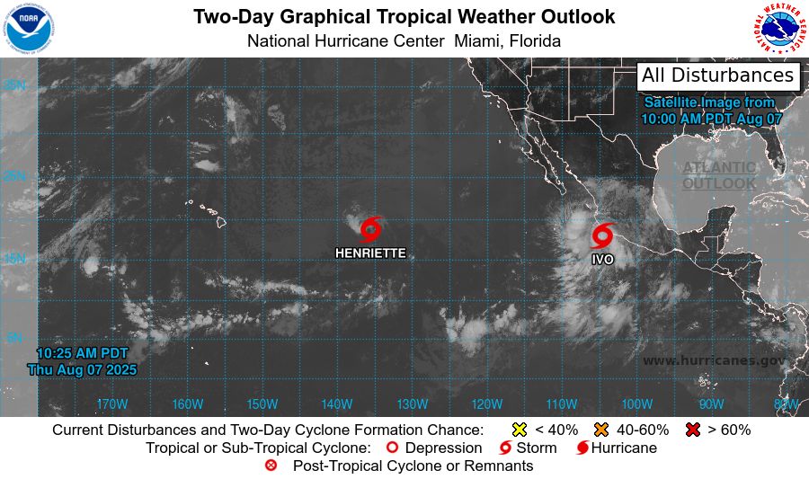
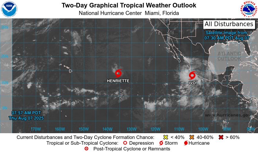
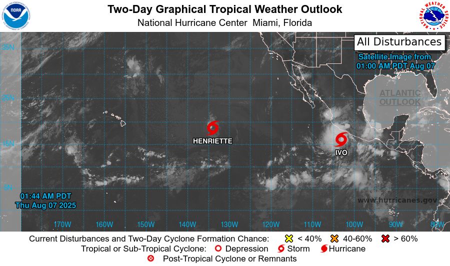
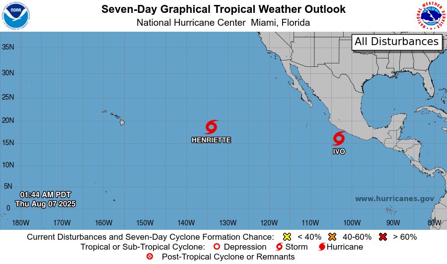
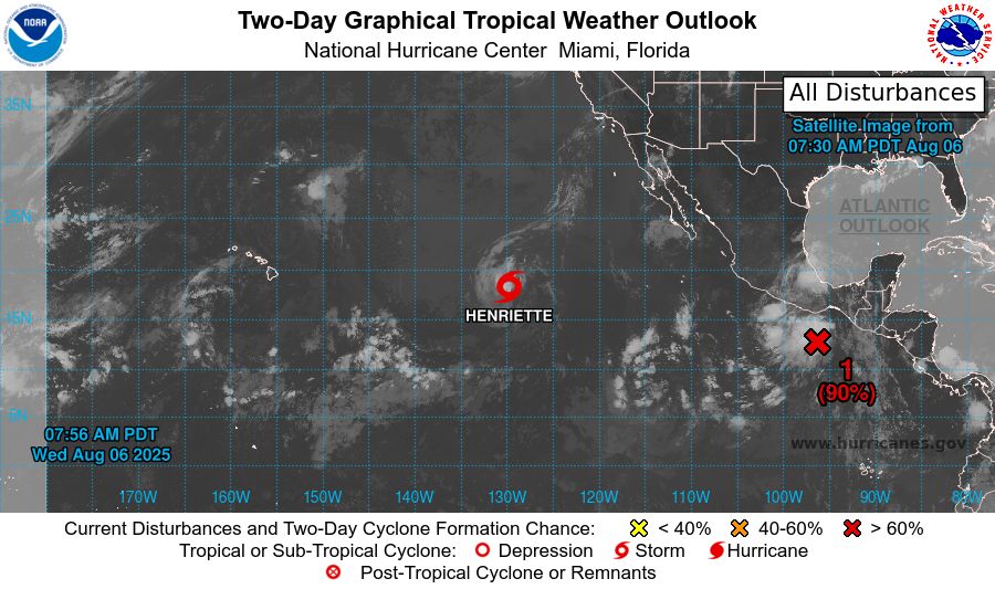
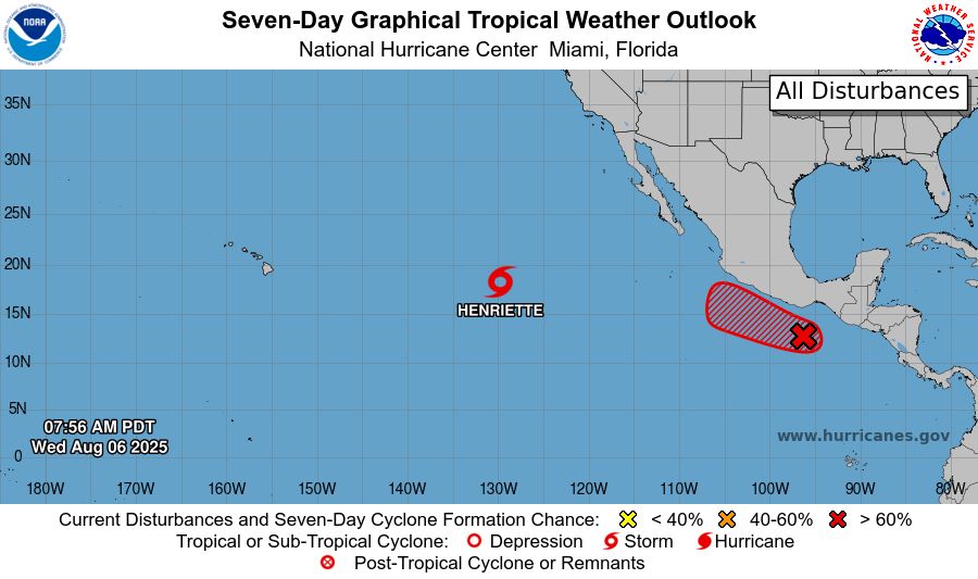
ZCZC MIATWOEP ALL<br>TTAA00 KNHC DDHHMM<br><br>Tropical Weather Outlook<br>NWS National Hurricane Center Miami FL<br>1100 AM PDT Thu Aug 7 2025<br><br>For the eastern and central North Pacific east of 180 longitude:<br><br>Active Systems: <br>The National Hurricane Center is issuing advisories on Tropical <br>Storm Henriette, located well east of the Hawaiian Islands. <br>Henriette is expected to move into the Central Pacific basin by <br>tonight. The National Hurricane Center is also issuing <br>advisories on Tropical Storm Ivo, located over the eastern <br>Pacific offshore of the coast of Southwestern Mexico. <br><br>Tropical cyclone formation is not expected over the next 7 days. <br><br>&&<br>Public Advisories on Tropical Storm Ivo are issued under WMO <br>header WTPZ34 KNHC and under AWIPS header MIATCPEP4. <br>Forecast/Advisories on Tropical Storm Ivo are issued under <br>WMO header WTPZ24 KNHC and under AWIPS header MIATCMEP4. <br><br>$$<br>Forecaster Papin<br>NNNN<br><br><br>
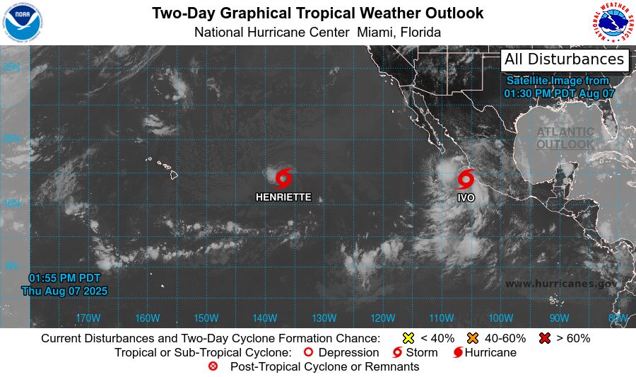
Eastern North Pacific 2-Day Graphical Outlook Image
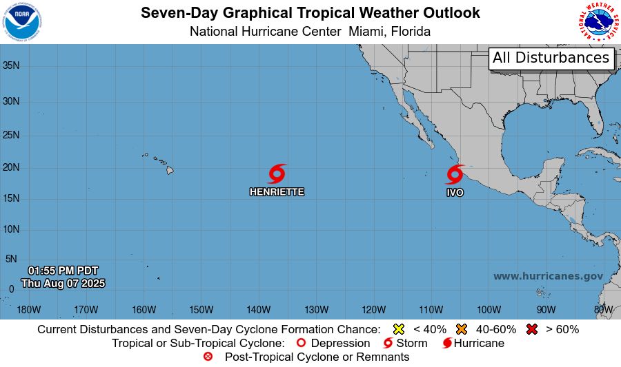
Eastern North Pacific 7-Day Graphical Outlook Image
NHC Eastern North Pacific Outlook update for Thu, 07 Aug 2025 20:55:17 UTC
Additional Details Here.
07.08.2025 21:00 — 👍 0 🔁 0 💬 0 📌 0
ZCZC MIATWOEP ALL<br>TTAA00 KNHC DDHHMM<br><br>Tropical Weather Outlook<br>NWS National Hurricane Center Miami FL<br>1100 AM PDT Thu Aug 7 2025<br><br>For the eastern and central North Pacific east of 180 longitude:<br><br>Active Systems: <br>The National Hurricane Center is issuing advisories on Tropical <br>Storm Henriette, located well east of the Hawaiian Islands. <br>Henriette is expected to move into the Central Pacific basin by <br>tonight. The National Hurricane Center is also issuing <br>advisories on Tropical Storm Ivo, located over the eastern <br>Pacific offshore of the coast of Southwestern Mexico. <br><br>Tropical cyclone formation is not expected over the next 7 days. <br><br>&&<br>Public Advisories on Tropical Storm Ivo are issued under WMO <br>header WTPZ34 KNHC and under AWIPS header MIATCPEP4. <br>Forecast/Advisories on Tropical Storm Ivo are issued under <br>WMO header WTPZ24 KNHC and under AWIPS header MIATCMEP4. <br><br>$$<br>Forecaster Papin<br>NNNN<br><br><br>
Eastern North Pacific 2-Day Graphical Outlook Image

Eastern North Pacific 7-Day Graphical Outlook Image
NHC Eastern North Pacific Outlook update for Thu, 07 Aug 2025 17:25:57 UTC
Additional Details Here.
07.08.2025 17:30 — 👍 0 🔁 0 💬 0 📌 0
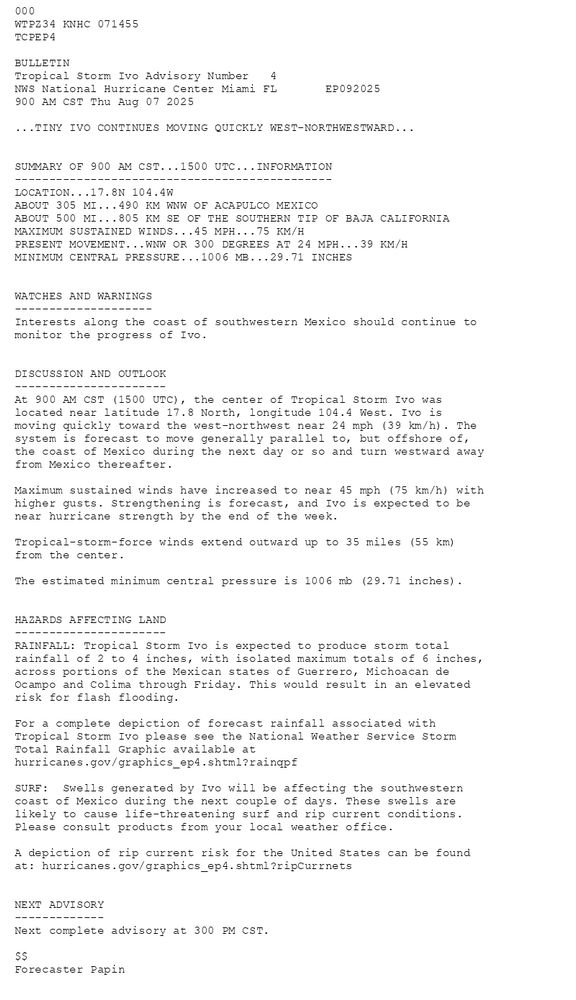
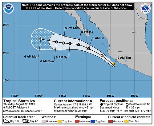
000WTPZ34 KNHC 071455TCPEP4 BULLETINTropical Storm Ivo Advisory Number 4NWS National Hurricane Center Miami FL EP092025900 AM CST Thu Aug 07 2025 ...TINY IVO CONTINUES MOVING QUICKLY WEST-NORTHWESTWARD... SUMMARY OF 900 AM CST...1500 UTC...INFORMATION----------------------------------------------LOCATION...17.8N 104.4WABOUT 305 MI...490 KM WNW OF ACAPULCO MEXICOABOUT 500 MI...805 KM SE OF THE SOUTHERN TIP OF BAJA CALIFORNIAMAXIMUM SUSTAINED WINDS...45 MPH...75 KM/HPRESENT MOVEMENT...WNW OR 300 DEGREES AT 24 MPH...39 KM/HMINIMUM CENTRAL PRESSURE...1006 MB...29.71 INCHES WATCHES AND WARNINGS--------------------Interests along the coast of southwestern Mexico should continue tomonitor the progress of Ivo. DISCUSSION AND OUTLOOK----------------------At 900 AM CST (1500 UTC), the center of Tropical Storm Ivo was located near latitude 17.8 North, longitude 104.4 West. Ivo is moving quickly toward the west-northwest near 24 mph (39 km/h). The system is forecast to move generally parallel to, but offshore of, the coast of Mexico during the next day or so and turn westward away from Mexico thereafter. Maximum sustained winds have increased to near 45 mph (75 km/h) withhigher gusts. Strengthening is forecast, and Ivo is expected to benear hurricane strength by the end of the week. Tropical-storm-force winds extend outward up to 35 miles (55 km)from the center. The estimated minimum central pressure is 1006 mb (29.71 inches). HAZARDS AFFECTING LAND----------------------RAINFALL: Tropical Storm Ivo is expected to produce storm totalrainfall of 2 to 4 inches, with isolated maximum totals of 6 inches,across portions of the Mexican states of Guerrero, Michoacan deOcampo and Colima through Friday. This would result in an elevatedrisk for flash flooding. For a complete depiction of forecast rainfall associated withTropical Storm Ivo please see the National Weather Service StormTotal Rainfall Graphic available athurricanes.gov/graphics_ep4.shtml?rainqpf SURF: Swells generated by Ivo will be affecting the southwesterncoast of Mexico during the next couple of days. These swells arelikely to cause life-threatening surf and rip current conditions.Please consult products from your local weather office. A depiction of rip current risk for the United States can be foundat: hurricanes.gov/graphics_ep4.shtml?ripCurrnets NEXT ADVISORY-------------Next complete advisory at 300 PM CST. $$Forecaster Papin
Tropical Storm Ivo 5-Day Uncertainty Track Image
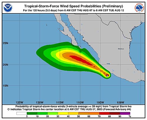
Tropical Storm Ivo 34-Knot Wind Speed Probabilities
Eastern North Pacific Tropical Storm Ivo Advisory Number 4 issued at Thu, 07 Aug 2025 14:55:21 +0000
...TINY IVO CONTINUES MOVING QUICKLY WEST-NORTHWESTWARD...
Additional Details Here.
07.08.2025 15:00 — 👍 0 🔁 0 💬 0 📌 0
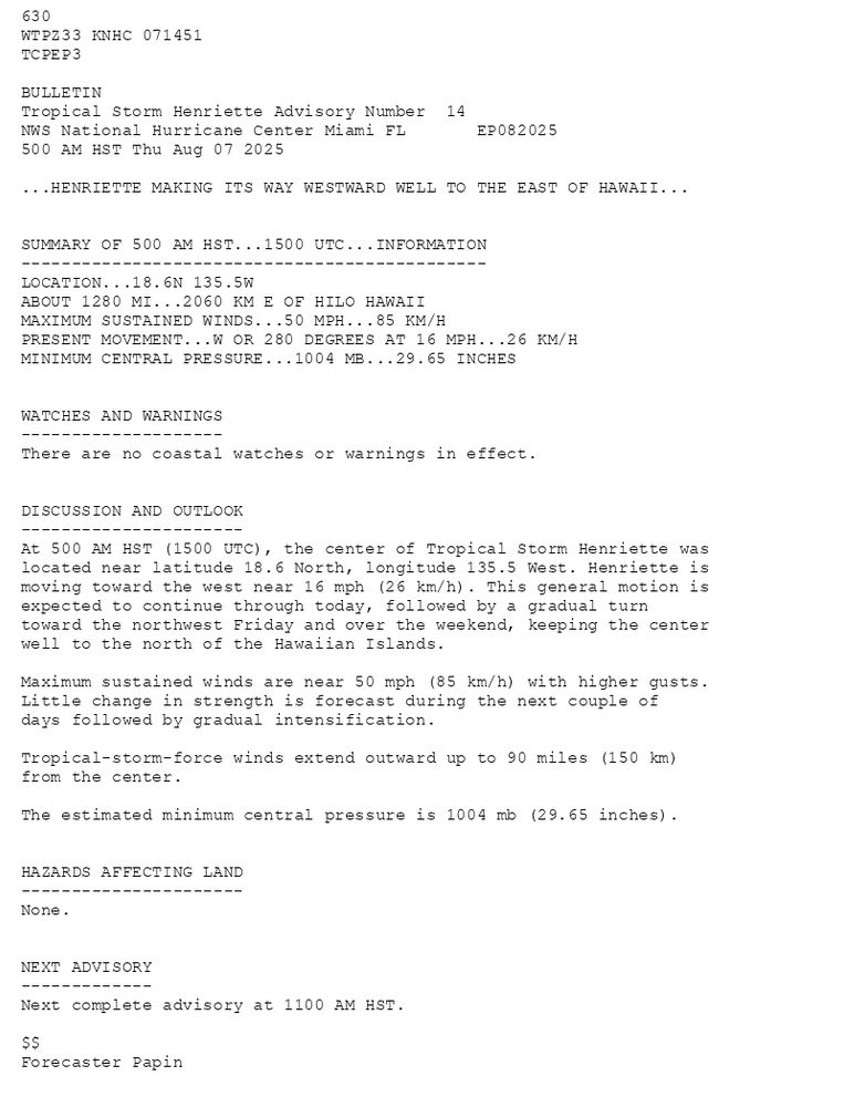
630 WTPZ33 KNHC 071451TCPEP3 BULLETINTropical Storm Henriette Advisory Number 14NWS National Hurricane Center Miami FL EP082025500 AM HST Thu Aug 07 2025 ...HENRIETTE MAKING ITS WAY WESTWARD WELL TO THE EAST OF HAWAII... SUMMARY OF 500 AM HST...1500 UTC...INFORMATION----------------------------------------------LOCATION...18.6N 135.5WABOUT 1280 MI...2060 KM E OF HILO HAWAIIMAXIMUM SUSTAINED WINDS...50 MPH...85 KM/HPRESENT MOVEMENT...W OR 280 DEGREES AT 16 MPH...26 KM/HMINIMUM CENTRAL PRESSURE...1004 MB...29.65 INCHES WATCHES AND WARNINGS--------------------There are no coastal watches or warnings in effect. DISCUSSION AND OUTLOOK----------------------At 500 AM HST (1500 UTC), the center of Tropical Storm Henriette was located near latitude 18.6 North, longitude 135.5 West. Henriette is moving toward the west near 16 mph (26 km/h). This general motion is expected to continue through today, followed by a gradual turn toward the northwest Friday and over the weekend, keeping the center well to the north of the Hawaiian Islands. Maximum sustained winds are near 50 mph (85 km/h) with higher gusts.Little change in strength is forecast during the next couple of days followed by gradual intensification. Tropical-storm-force winds extend outward up to 90 miles (150 km)from the center. The estimated minimum central pressure is 1004 mb (29.65 inches). HAZARDS AFFECTING LAND----------------------None. NEXT ADVISORY-------------Next complete advisory at 1100 AM HST. $$Forecaster Papin
Tropical Storm Henriette 5-Day Uncertainty Track Image
Tropical Storm Henriette 34-Knot Wind Speed Probabilities
Eastern North Pacific Tropical Storm Henriette Advisory Number 14 issued at Thu, 07 Aug 2025 14:51:35 +0000
...HENRIETTE MAKING ITS WAY WESTWARD WELL TO THE EAST OF HAWAII...
Additional Details Here.
07.08.2025 15:00 — 👍 0 🔁 0 💬 0 📌 0
ZCZC MIATWOEP ALL<br>TTAA00 KNHC DDHHMM<br><br>Tropical Weather Outlook<br>NWS National Hurricane Center Miami FL<br>500 AM PDT Thu Aug 7 2025<br><br>For the eastern and central North Pacific east of 180 longitude:<br><br>Active Systems: <br>The National Hurricane Center is issuing advisories on Tropical <br>Storm Henriette, located well east of the Hawaiian Islands. <br>Henriette is expected to move into the Central Pacific basin <br>Thursday night. The National Hurricane Center is also issuing <br>advisories on Tropical Storm Ivo, located offshore of the coast of <br>Southwestern Mexico. <br><br>Tropical cyclone formation is not expected over the next 7 days. <br><br>&&<br>Public Advisories on Tropical Storm Ivo are issued under WMO <br>header WTPZ34 KNHC and under AWIPS header MIATCPEP4. <br>Forecast/Advisories on Tropical Storm Ivo are issued under <br>WMO header WTPZ24 KNHC and under AWIPS header MIATCMEP4. <br><br>$$<br>Forecaster Papin<br>NNNN<br><br><br>
Eastern North Pacific 2-Day Graphical Outlook Image

Eastern North Pacific 7-Day Graphical Outlook Image
NHC Eastern North Pacific Outlook update for Thu, 07 Aug 2025 14:57:17 UTC
Additional Details Here.
07.08.2025 15:00 — 👍 0 🔁 0 💬 0 📌 0
ZCZC MIATWOEP ALL<br>TTAA00 KNHC DDHHMM<br><br>Tropical Weather Outlook<br>NWS National Hurricane Center Miami FL<br>500 AM PDT Thu Aug 7 2025<br><br>For the eastern and central North Pacific east of 180 longitude:<br><br>Active Systems: <br>The National Hurricane Center is issuing advisories on Tropical <br>Storm Henriette, located well east of the Hawaiian Islands. <br>Henriette is expected to move into the Central Pacific basin <br>Thursday night. The National Hurricane Center is also issuing <br>advisories on Tropical Storm Ivo, located offshore of the coast of <br>Southwestern Mexico. <br><br>Tropical cyclone formation is not expected over the next 7 days. <br><br>&&<br>Public Advisories on Tropical Storm Ivo are issued under WMO <br>header WTPZ34 KNHC and under AWIPS header MIATCPEP4. <br>Forecast/Advisories on Tropical Storm Ivo are issued under <br>WMO header WTPZ24 KNHC and under AWIPS header MIATCMEP4. <br><br>$$<br>Forecaster Papin<br>NNNN<br><br><br>
Eastern North Pacific 2-Day Graphical Outlook Image

Eastern North Pacific 7-Day Graphical Outlook Image
NHC Eastern North Pacific Outlook update for Thu, 07 Aug 2025 11:33:42 UTC
Additional Details Here.
07.08.2025 11:40 — 👍 0 🔁 0 💬 0 📌 0
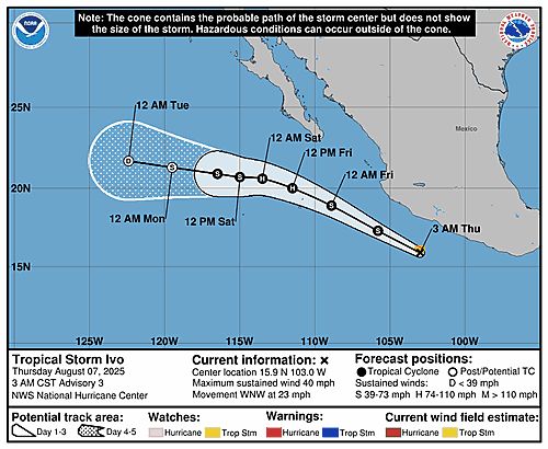
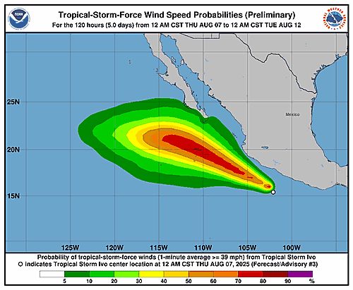
![306 WTPZ34 KNHC 070844TCPEP4 BULLETINTropical Storm Ivo Advisory Number 3NWS National Hurricane Center Miami FL EP092025300 AM CST Thu Aug 07 2025 ...IVO RACING WEST-NORTHWESTWARD OFF THE SOUTHWESTERN MEXICANCOASTLINE... SUMMARY OF 300 AM CST...0900 UTC...INFORMATION----------------------------------------------LOCATION...15.9N 103.0WABOUT 215 MI...350 KM WSW OF ACAPULCO MEXICOMAXIMUM SUSTAINED WINDS...40 MPH...65 KM/HPRESENT MOVEMENT...WNW OR 295 DEGREES AT 23 MPH...37 KM/HMINIMUM CENTRAL PRESSURE...1008 MB...29.77 INCHES WATCHES AND WARNINGS--------------------Interests along the coast of southwestern Mexico should monitor theprogress of Ivo. DISCUSSION AND OUTLOOK----------------------At 300 AM CST (0900 UTC), the center of Tropical Storm Ivo was located near latitude 15.9 North, longitude 103.0 West. Ivo is moving toward the west-northwest near 23 mph (37 km/h). The system is forecast to move generally parallel to, but offshore of, the coast of Mexico during the next day or so and turn westward away from Mexico thereafter. Maximum sustained winds are near 40 mph (65 km/h) with higher gusts.Strengthening is forecast, and Ivo is expected to be near hurricanestrength by the end of the week. Tropical-storm-force winds extend outward up to 35 miles (55 km)from the center. The estimated minimum central pressure is 1008 mb (29.77 inches). HAZARDS AFFECTING LAND----------------------RAINFALL: Tropical Storm Ivo is expected to produce storm totalrainfall of 2 to 4 inches, with isolated maximum totals of 6 inches,across portions of the Mexican states of Guerrero, Michoacan deOcampo and Colima through Friday. This would result in an elevatedrisk for flash flooding. For a complete depiction of forecast rainfall associated withTropical Depression Nine-E, please see the National Weather ServiceStorm Total Rainfall Graphic available athurricanes.gov/graphics_ep4.shtml?rainqpf SURF: Swells generated by Ivo will be affecting the southwesterncoast of Mexico during the next couple of days. These swells arelikely to cause life-threatening surf and rip current conditions.Please consult products from your local weather office. A depiction of rip current risk for the United States can be foundat: hurricanes.gov/graphics_at[X].shtml?ripCurrnets NEXT ADVISORY-------------Next complete advisory at 900 AM CST. $$Forecaster Bucci](https://cdn.bsky.app/img/feed_thumbnail/plain/did:plc:6dctdb6hkovpvazy5r2t6ofg/bafkreidti43nuejpjpdzas6ytgmr7tjcf54eg5xm7dxluwh7ssvhkblx7m@jpeg)
306 WTPZ34 KNHC 070844TCPEP4 BULLETINTropical Storm Ivo Advisory Number 3NWS National Hurricane Center Miami FL EP092025300 AM CST Thu Aug 07 2025 ...IVO RACING WEST-NORTHWESTWARD OFF THE SOUTHWESTERN MEXICANCOASTLINE... SUMMARY OF 300 AM CST...0900 UTC...INFORMATION----------------------------------------------LOCATION...15.9N 103.0WABOUT 215 MI...350 KM WSW OF ACAPULCO MEXICOMAXIMUM SUSTAINED WINDS...40 MPH...65 KM/HPRESENT MOVEMENT...WNW OR 295 DEGREES AT 23 MPH...37 KM/HMINIMUM CENTRAL PRESSURE...1008 MB...29.77 INCHES WATCHES AND WARNINGS--------------------Interests along the coast of southwestern Mexico should monitor theprogress of Ivo. DISCUSSION AND OUTLOOK----------------------At 300 AM CST (0900 UTC), the center of Tropical Storm Ivo was located near latitude 15.9 North, longitude 103.0 West. Ivo is moving toward the west-northwest near 23 mph (37 km/h). The system is forecast to move generally parallel to, but offshore of, the coast of Mexico during the next day or so and turn westward away from Mexico thereafter. Maximum sustained winds are near 40 mph (65 km/h) with higher gusts.Strengthening is forecast, and Ivo is expected to be near hurricanestrength by the end of the week. Tropical-storm-force winds extend outward up to 35 miles (55 km)from the center. The estimated minimum central pressure is 1008 mb (29.77 inches). HAZARDS AFFECTING LAND----------------------RAINFALL: Tropical Storm Ivo is expected to produce storm totalrainfall of 2 to 4 inches, with isolated maximum totals of 6 inches,across portions of the Mexican states of Guerrero, Michoacan deOcampo and Colima through Friday. This would result in an elevatedrisk for flash flooding. For a complete depiction of forecast rainfall associated withTropical Depression Nine-E, please see the National Weather ServiceStorm Total Rainfall Graphic available athurricanes.gov/graphics_ep4.shtml?rainqpf SURF: Swells generated by Ivo will be affecting the southwesterncoast of Mexico during the next couple of days. These swells arelikely to cause life-threatening surf and rip current conditions.Please consult products from your local weather office. A depiction of rip current risk for the United States can be foundat: hurricanes.gov/graphics_at[X].shtml?ripCurrnets NEXT ADVISORY-------------Next complete advisory at 900 AM CST. $$Forecaster Bucci
Tropical Storm Ivo 5-Day Uncertainty Track Image
Tropical Storm Ivo 34-Knot Wind Speed Probabilities
Eastern North Pacific Tropical Storm Ivo Advisory Number 3 issued at Thu, 07 Aug 2025 08:44:35 +0000
...IVO RACING WEST-NORTHWESTWARD OFF THE SOUTHWESTERN MEXICAN COASTLINE...
Additional Details Here.
07.08.2025 08:50 — 👍 1 🔁 0 💬 0 📌 0
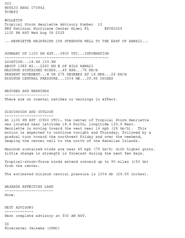
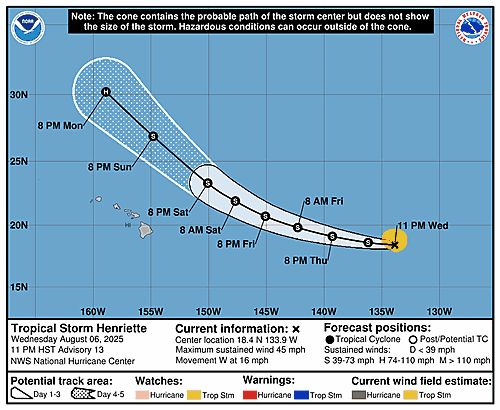
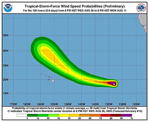
000WTPZ33 KNHC 070842TCPEP3 BULLETINTropical Storm Henriette Advisory Number 13NWS National Hurricane Center Miami FL EP0820251100 PM HST Wed Aug 06 2025 ...HENRIETTE MAINTAINS ITS STRENGTH WELL TO THE EAST OF HAWAII... SUMMARY OF 1100 PM HST...0900 UTC...INFORMATION-----------------------------------------------LOCATION...18.4N 133.9WABOUT 1385 MI...2230 KM E OF HILO HAWAIIMAXIMUM SUSTAINED WINDS...45 MPH...75 KM/HPRESENT MOVEMENT...W OR 275 DEGREES AT 16 MPH...26 KM/HMINIMUM CENTRAL PRESSURE...1004 MB...29.65 INCHES WATCHES AND WARNINGS--------------------There are no coastal watches or warnings in effect. DISCUSSION AND OUTLOOK----------------------At 1100 PM HST (0900 UTC), the center of Tropical Storm Henriette was located near latitude 18.4 North, longitude 133.9 West. Henriette is moving toward the west near 16 mph (26 km/h). This motion is expected to continue tonight and Thursday, followed by a gradual turn toward the northwest Friday and over the weekend, keeping the center well to the north of the Hawaiian Islands. Maximum sustained winds are near 45 mph (75 km/h) with higher gusts.Little change in strength is forecast during the next few days. Tropical-storm-force winds extend outward up to 90 miles (150 km)from the center. The estimated minimum central pressure is 1004 mb (29.65 inches). HAZARDS AFFECTING LAND----------------------None. NEXT ADVISORY-------------Next complete advisory at 500 AM HST. $$Forecaster Jelsema (CPHC)
Tropical Storm Henriette 5-Day Uncertainty Track Image
Tropical Storm Henriette 34-Knot Wind Speed Probabilities
Eastern North Pacific Tropical Storm Henriette Advisory Number 13 issued at Thu, 07 Aug 2025 08:42:45 +0000
...HENRIETTE MAINTAINS ITS STRENGTH WELL TO THE EAST OF HAWAII...
Additional Details Here.
07.08.2025 08:50 — 👍 0 🔁 0 💬 0 📌 0
ZCZC MIATWOEP ALL<br>TTAA00 KNHC DDHHMM<br><br>Tropical Weather Outlook<br>NWS National Hurricane Center Miami FL<br>1100 PM PDT Wed Aug 6 2025<br><br>For the eastern and central North Pacific east of 180 longitude:<br><br>Active Systems: <br>The National Hurricane Center is issuing advisories on Tropical <br>Storm Henriette, located well east of the Hawaiian Islands. <br>Henriette is expected to move into the Central Pacific basin <br>Thursday night. <br><br>The National Hurricane Center is also issuing <br>advisories on Tropical Storm Ivo, located about 150 miles offshore <br>the coast of Southwestern Mexico. <br><br>Tropical cyclone formation is not expected over the next 7 days. <br><br>&&<br><br>Public Advisories on Tropical Storm Ivo are issued under WMO <br>header WTPZ34 KNHC and under AWIPS header MIATCPEP4. <br>Forecast/Advisories on Tropical Storm Ivo are issued under <br>WMO header WTPZ24 KNHC and under AWIPS header MIATCMEP4. <br><br>$$<br>Forecaster Jelsema/Bucci<br>NNNN<br><br><br>
Eastern North Pacific 2-Day Graphical Outlook Image
Eastern North Pacific 7-Day Graphical Outlook Image
NHC Eastern North Pacific Outlook update for Thu, 07 Aug 2025 08:44:17 UTC
Additional Details Here.
07.08.2025 08:50 — 👍 0 🔁 0 💬 0 📌 0
ZCZC MIATWOEP ALL<br>TTAA00 KNHC DDHHMM<br><br>Tropical Weather Outlook<br>NWS National Hurricane Center Miami FL<br>1100 PM PDT Wed Aug 6 2025<br><br>For the eastern and central North Pacific east of 180 longitude:<br><br>Active Systems: <br>The National Hurricane Center is issuing advisories on Tropical <br>Storm Henriette, located well east of the Hawaiian Islands. <br>Henriette is expected to move into the Central Pacific basin <br>Thursday night. <br><br>The National Hurricane Center is also issuing <br>advisories on Tropical Storm Ivo, located about 150 miles offshore <br>the coast of Southwestern Mexico. <br><br>Tropical cyclone formation is not expected over the next 7 days. <br><br>&&<br><br>Public Advisories on Tropical Storm Ivo are issued under WMO <br>header WTPZ34 KNHC and under AWIPS header MIATCPEP4. <br>Forecast/Advisories on Tropical Storm Ivo are issued under <br>WMO header WTPZ24 KNHC and under AWIPS header MIATCMEP4. <br><br>$$<br>Forecaster Jelsema/Bucci<br>NNNN<br><br><br>
Eastern North Pacific 2-Day Graphical Outlook Image

Eastern North Pacific 7-Day Graphical Outlook Image
NHC Eastern North Pacific Outlook update for Thu, 07 Aug 2025 05:06:43 UTC
Additional Details Here.
07.08.2025 05:10 — 👍 0 🔁 0 💬 0 📌 0
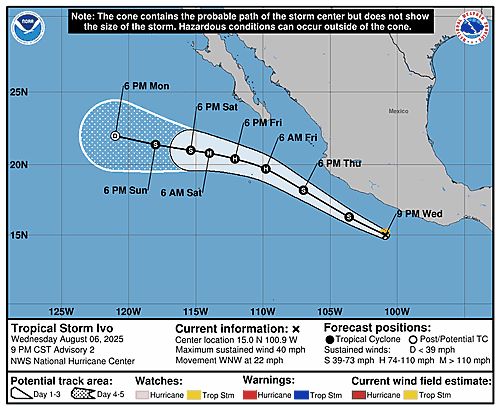
![998 WTPZ34 KNHC 070239TCPEP4 BULLETINTropical Storm Ivo Advisory Number 2NWS National Hurricane Center Miami FL EP092025900 PM CST Wed Aug 06 2025 ...IVO BRINGING LOCALLY HEAVY RAINS TO PORTIONS OF THE COAST OFSOUTHWESTERN MEXICO... SUMMARY OF 900 PM CST...0300 UTC...INFORMATION----------------------------------------------LOCATION...15.0N 100.9WABOUT 145 MI...235 KM SSW OF ACAPULCO MEXICOMAXIMUM SUSTAINED WINDS...40 MPH...65 KM/HPRESENT MOVEMENT...WNW OR 295 DEGREES AT 22 MPH...35 KM/HMINIMUM CENTRAL PRESSURE...1008 MB...29.77 INCHES WATCHES AND WARNINGS--------------------Interests along the coast of southwestern Mexico should monitor theprogress of Ivo. DISCUSSION AND OUTLOOK----------------------At 900 PM CST (0300 UTC), the center of Tropical Storm Ivo waslocated near latitude 15.0 North, longitude 100.9 West. Ivo ismoving toward the west-northwest near 22 mph (35 km/h). The system is forecast to move generally parallel to, but offshore of, the coast of Mexico during the next day or two and move away from Mexico thereafter.Maximum sustained winds are near 40 mph (65 km/h) with higher gusts.Strengthening is forecast, and Ivo is expected to be near hurricane strength by the end of the week. Tropical-storm-force winds extend outward up to 35 miles (55 km)from the center. The estimated minimum central pressure is 1008 mb (29.77 inches). HAZARDS AFFECTING LAND----------------------RAINFALL: Tropical Storm Ivo is expected to produce storm totalrainfall of 2 to 4 inches, with isolated maximum totals of 6 inches,across portions of the Mexican states of Guerrero, Michoacan andsouthwestern Oaxaca through Saturday. This rainfall could lead toflash flooding. For a complete depiction of forecast rainfall associated withTropical Storm Ivo, please see the National Weather ServiceStorm Total Rainfall Graphic available athurricanes.gov/graphics_ep4.shtml?rainqpf SURF: Swells generated by Ivo will be affecting the southwesterncoast of Mexico during the next couple of days. These swells arelikely to cause life-threatening surf and rip current conditions.Please consult products from your local weather office. A depiction of rip current risk for the United States can be foundat:hurricanes.gov/graphics_at[X].shtml?ripCurrnets NEXT ADVISORY-------------Next complete advisory at 300 AM CST. $$Forecaster Pasch](https://cdn.bsky.app/img/feed_thumbnail/plain/did:plc:6dctdb6hkovpvazy5r2t6ofg/bafkreiezvw6p5swryoyh3hldmbyiymj76x4ipk5sbwe2mtdbdconye5gvu@jpeg)
998 WTPZ34 KNHC 070239TCPEP4 BULLETINTropical Storm Ivo Advisory Number 2NWS National Hurricane Center Miami FL EP092025900 PM CST Wed Aug 06 2025 ...IVO BRINGING LOCALLY HEAVY RAINS TO PORTIONS OF THE COAST OFSOUTHWESTERN MEXICO... SUMMARY OF 900 PM CST...0300 UTC...INFORMATION----------------------------------------------LOCATION...15.0N 100.9WABOUT 145 MI...235 KM SSW OF ACAPULCO MEXICOMAXIMUM SUSTAINED WINDS...40 MPH...65 KM/HPRESENT MOVEMENT...WNW OR 295 DEGREES AT 22 MPH...35 KM/HMINIMUM CENTRAL PRESSURE...1008 MB...29.77 INCHES WATCHES AND WARNINGS--------------------Interests along the coast of southwestern Mexico should monitor theprogress of Ivo. DISCUSSION AND OUTLOOK----------------------At 900 PM CST (0300 UTC), the center of Tropical Storm Ivo waslocated near latitude 15.0 North, longitude 100.9 West. Ivo ismoving toward the west-northwest near 22 mph (35 km/h). The system is forecast to move generally parallel to, but offshore of, the coast of Mexico during the next day or two and move away from Mexico thereafter.Maximum sustained winds are near 40 mph (65 km/h) with higher gusts.Strengthening is forecast, and Ivo is expected to be near hurricane strength by the end of the week. Tropical-storm-force winds extend outward up to 35 miles (55 km)from the center. The estimated minimum central pressure is 1008 mb (29.77 inches). HAZARDS AFFECTING LAND----------------------RAINFALL: Tropical Storm Ivo is expected to produce storm totalrainfall of 2 to 4 inches, with isolated maximum totals of 6 inches,across portions of the Mexican states of Guerrero, Michoacan andsouthwestern Oaxaca through Saturday. This rainfall could lead toflash flooding. For a complete depiction of forecast rainfall associated withTropical Storm Ivo, please see the National Weather ServiceStorm Total Rainfall Graphic available athurricanes.gov/graphics_ep4.shtml?rainqpf SURF: Swells generated by Ivo will be affecting the southwesterncoast of Mexico during the next couple of days. These swells arelikely to cause life-threatening surf and rip current conditions.Please consult products from your local weather office. A depiction of rip current risk for the United States can be foundat:hurricanes.gov/graphics_at[X].shtml?ripCurrnets NEXT ADVISORY-------------Next complete advisory at 300 AM CST. $$Forecaster Pasch
Tropical Storm Ivo 5-Day Uncertainty Track Image
Tropical Storm Ivo 34-Knot Wind Speed Probabilities
Eastern North Pacific Tropical Storm Ivo Advisory Number 2 issued at Thu, 07 Aug 2025 02:40:11 +0000
...IVO BRINGING LOCALLY HEAVY RAINS TO PORTIONS OF THE COAST OF SOUTHWESTERN MEXICO...
Additional Details Here.
07.08.2025 02:50 — 👍 2 🔁 0 💬 0 📌 0
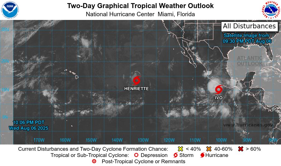
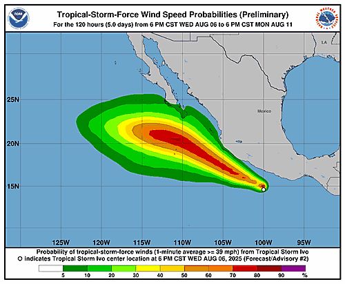
ZCZC MIATWOEP ALL<br>TTAA00 KNHC DDHHMM<br><br>Tropical Weather Outlook<br>NWS National Hurricane Center Miami FL<br>500 PM PDT Wed Aug 6 2025<br><br>For the eastern and central North Pacific east of 180 longitude:<br><br>Active Systems: <br>The National Hurricane Center is issuing advisories on Tropical <br>Storm Henriette, located well east of the Hawaiian Islands. <br>Henriette is expected to move into the Central Pacific basin <br>Thursday night. <br><br>The National Hurricane Center is also issuing advisories on Tropical <br>Storm Ivo, located a couple hundred miles offshore the coast of <br>Southern Mexico. <br><br>Tropical cyclone formation is not expected over the next 7 days. <br><br>&&<br><br>Public Advisories on Tropical Storm Ivo are issued under WMO <br>header WTPZ34 KNHC and under AWIPS header MIATCPEP4. <br>Forecast/Advisories on Tropical Storm Ivo are issued under <br>WMO header WTPZ24 KNHC and under AWIPS header MIATCMEP4. <br><br>$$<br>Forecaster Jelsema<br>NNNN<br><br><br>

Eastern North Pacific 2-Day Graphical Outlook Image

Eastern North Pacific 7-Day Graphical Outlook Image
NHC Eastern North Pacific Outlook update for Thu, 07 Aug 2025 02:40:24 UTC
Additional Details Here.
07.08.2025 02:50 — 👍 0 🔁 0 💬 0 📌 0
![ZCZC MIATCPEP4 ALLTTAA00 KNHC DDHHMM BULLETINTropical Storm Ivo Advisory Number 2NWS National Hurricane Center Miami FL EP092025900 PM CST Wed Aug 06 2025 ...IVO BRINGING LOCALLY HEAVY RAINS TO PORTIONS OF THE COAST OFSOUTHWESTERN MEXICO... SUMMARY OF 900 PM CST...0300 UTC...INFORMATION----------------------------------------------LOCATION...15.0N 100.9WABOUT 145 MI...235 KM SSW OF ACAPULCO MEXICOMAXIMUM SUSTAINED WINDS...40 MPH...65 KM/HPRESENT MOVEMENT...WNW OR 295 DEGREES AT 22 MPH...35 KM/HMINIMUM CENTRAL PRESSURE...1008 MB...29.77 INCHES WATCHES AND WARNINGS--------------------Interests along the coast of southwestern Mexico should monitor theprogress of Ivo. DISCUSSION AND OUTLOOK----------------------At 900 PM CST (0300 UTC), the center of Tropical Storm Ivo waslocated near latitude 15.0 North, longitude 100.9 West. Ivo ismoving toward the west-northwest near 22 mph (35 km/h). The system is forecast to move generally parallel to, but offshore of, the coast of Mexico during the next day or two and move away from Mexico thereafter.Maximum sustained winds are near 40 mph (65 km/h) with higher gusts.Strengthening is forecast, and Ivo is expected to be near hurricane strength by the end of the week. Tropical-storm-force winds extend outward up to 35 miles (55 km)from the center. The estimated minimum central pressure is 1008 mb (29.77 inches). HAZARDS AFFECTING LAND----------------------RAINFALL: Tropical Storm Ivo is expected to produce storm totalrainfall of 2 to 4 inches, with isolated maximum totals of 6 inches,across portions of the Mexican states of Guerrero, Michoacan andsouthwestern Oaxaca through Saturday. This rainfall could lead toflash flooding. For a complete depiction of forecast rainfall associated withTropical Storm Ivo, please see the National Weather ServiceStorm Total Rainfall Graphic available athurricanes.gov/graphics_ep4.shtml?rainqpf SURF: Swells generated by Ivo will be affecting the southwesterncoast of Mexico during the next couple of days. These swells arelikely to cause life-threatening surf and rip current conditions.Please consult products from your local weather office. A depiction of rip current risk for the United States can be foundat:hurricanes.gov/graphics_at[X].shtml?ripCurrnets NEXT ADVISORY-------------Next complete advisory at 300 AM CST. $$Forecaster Pasch NNNN](https://cdn.bsky.app/img/feed_thumbnail/plain/did:plc:6dctdb6hkovpvazy5r2t6ofg/bafkreige2m2iievik42as6l7ggfqvhfs6kfevzt3nnkj3xaaga6xi3x2vq@jpeg)
ZCZC MIATCPEP4 ALLTTAA00 KNHC DDHHMM BULLETINTropical Storm Ivo Advisory Number 2NWS National Hurricane Center Miami FL EP092025900 PM CST Wed Aug 06 2025 ...IVO BRINGING LOCALLY HEAVY RAINS TO PORTIONS OF THE COAST OFSOUTHWESTERN MEXICO... SUMMARY OF 900 PM CST...0300 UTC...INFORMATION----------------------------------------------LOCATION...15.0N 100.9WABOUT 145 MI...235 KM SSW OF ACAPULCO MEXICOMAXIMUM SUSTAINED WINDS...40 MPH...65 KM/HPRESENT MOVEMENT...WNW OR 295 DEGREES AT 22 MPH...35 KM/HMINIMUM CENTRAL PRESSURE...1008 MB...29.77 INCHES WATCHES AND WARNINGS--------------------Interests along the coast of southwestern Mexico should monitor theprogress of Ivo. DISCUSSION AND OUTLOOK----------------------At 900 PM CST (0300 UTC), the center of Tropical Storm Ivo waslocated near latitude 15.0 North, longitude 100.9 West. Ivo ismoving toward the west-northwest near 22 mph (35 km/h). The system is forecast to move generally parallel to, but offshore of, the coast of Mexico during the next day or two and move away from Mexico thereafter.Maximum sustained winds are near 40 mph (65 km/h) with higher gusts.Strengthening is forecast, and Ivo is expected to be near hurricane strength by the end of the week. Tropical-storm-force winds extend outward up to 35 miles (55 km)from the center. The estimated minimum central pressure is 1008 mb (29.77 inches). HAZARDS AFFECTING LAND----------------------RAINFALL: Tropical Storm Ivo is expected to produce storm totalrainfall of 2 to 4 inches, with isolated maximum totals of 6 inches,across portions of the Mexican states of Guerrero, Michoacan andsouthwestern Oaxaca through Saturday. This rainfall could lead toflash flooding. For a complete depiction of forecast rainfall associated withTropical Storm Ivo, please see the National Weather ServiceStorm Total Rainfall Graphic available athurricanes.gov/graphics_ep4.shtml?rainqpf SURF: Swells generated by Ivo will be affecting the southwesterncoast of Mexico during the next couple of days. These swells arelikely to cause life-threatening surf and rip current conditions.Please consult products from your local weather office. A depiction of rip current risk for the United States can be foundat:hurricanes.gov/graphics_at[X].shtml?ripCurrnets NEXT ADVISORY-------------Next complete advisory at 300 AM CST. $$Forecaster Pasch NNNN
Tropical Storm Ivo 5-Day Uncertainty Track Image
Tropical Storm Ivo 34-Knot Wind Speed Probabilities
Eastern North Pacific Tropical Storm Ivo Advisory Number 2 issued at Thu, 07 Aug 2025 02:39:19 +0000
...IVO BRINGING LOCALLY HEAVY RAINS TO PORTIONS OF THE COAST OF SOUTHWESTERN MEXICO...
Additional Details Here.
07.08.2025 02:40 — 👍 1 🔁 0 💬 0 📌 0
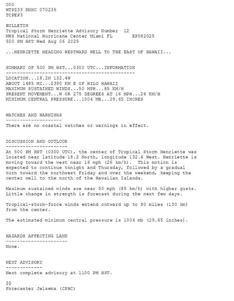
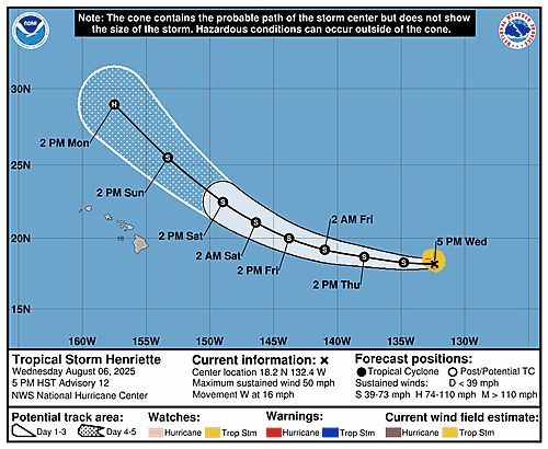
000WTPZ33 KNHC 070235TCPEP3 BULLETINTropical Storm Henriette Advisory Number 12NWS National Hurricane Center Miami FL EP082025500 PM HST Wed Aug 06 2025 ...HENRIETTE HEADING WESTWARD WELL TO THE EAST OF HAWAII... SUMMARY OF 500 PM HST...0300 UTC...INFORMATION----------------------------------------------LOCATION...18.2N 132.4WABOUT 1485 MI...2390 KM E OF HILO HAWAIIMAXIMUM SUSTAINED WINDS...50 MPH...85 KM/HPRESENT MOVEMENT...W OR 275 DEGREES AT 16 MPH...26 KM/HMINIMUM CENTRAL PRESSURE...1004 MB...29.65 INCHES WATCHES AND WARNINGS--------------------There are no coastal watches or warnings in effect. DISCUSSION AND OUTLOOK----------------------At 500 PM HST (0300 UTC), the center of Tropical Storm Henriette was located near latitude 18.2 North, longitude 132.4 West. Henriette is moving toward the west near 16 mph (26 km/h). This motion is expected to continue tonight and Thursday, followed by a gradual turn toward the northwest Friday and over the weekend, keeping the center well to the north of the Hawaiian Islands. Maximum sustained winds are near 50 mph (85 km/h) with higher gusts.Little change in strength is forecast during the next few days. Tropical-storm-force winds extend outward up to 80 miles (130 km)from the center. The estimated minimum central pressure is 1004 mb (29.65 inches). HAZARDS AFFECTING LAND----------------------None. NEXT ADVISORY-------------Next complete advisory at 1100 PM HST. $$Forecaster Jelsema (CPHC)
Tropical Storm Henriette 5-Day Uncertainty Track Image
Tropical Storm Henriette 34-Knot Wind Speed Probabilities
Eastern North Pacific Tropical Storm Henriette Advisory Number 12 issued at Thu, 07 Aug 2025 02:35:33 +0000
...HENRIETTE HEADING WESTWARD WELL TO THE EAST OF HAWAII...
Additional Details Here.
07.08.2025 02:40 — 👍 0 🔁 0 💬 0 📌 0
ZCZC MIATWOEP ALL<br>TTAA00 KNHC DDHHMM<br><br>Tropical Weather Outlook<br>NWS National Hurricane Center Miami FL<br>500 PM PDT Wed Aug 6 2025<br><br>For the eastern and central North Pacific east of 180 longitude:<br><br>Active Systems: <br>The National Hurricane Center is issuing advisories on Tropical <br>Storm Henriette, located well east of the Hawaiian Islands. <br>Henriette is expected to move into the Central Pacific basin <br>Thursday night. <br><br>The National Hurricane Center is also issuing advisories on Tropical <br>Storm Ivo, located a couple hundred miles offshore the coast of <br>Southern Mexico. <br><br>Tropical cyclone formation is not expected over the next 7 days. <br><br>&&<br><br>Public Advisories on Tropical Storm Ivo are issued under WMO <br>header WTPZ34 KNHC and under AWIPS header MIATCPEP4. <br>Forecast/Advisories on Tropical Storm Ivo are issued under <br>WMO header WTPZ24 KNHC and under AWIPS header MIATCMEP4. <br><br>$$<br>Forecaster Jelsema<br>NNNN<br><br><br>
Eastern North Pacific 2-Day Graphical Outlook Image

Eastern North Pacific 7-Day Graphical Outlook Image
NHC Eastern North Pacific Outlook update for Thu, 07 Aug 2025 02:34:18 UTC
Additional Details Here.
07.08.2025 02:40 — 👍 0 🔁 0 💬 0 📌 0
ZCZC MIATWOEP ALL<br>TTAA00 KNHC DDHHMM<br><br>Tropical Weather Outlook<br>NWS National Hurricane Center Miami FL<br>500 PM PDT Wed Aug 6 2025<br><br>For the eastern and central North Pacific east of 180 longitude:<br><br>Active Systems: <br>The National Hurricane Center is issuing advisories on Tropical <br>Storm Henriette, located well east of the Hawaiian Islands. <br>Henriette is expected to move into the Central Pacific basin <br>Thursday night. <br><br>The National Hurricane Center is also issuing advisories on Tropical <br>Storm Ivo, located a couple hundred miles offshore the coast of <br>Southern Mexico. <br><br>Tropical cyclone formation is not expected over the next 7 days. <br><br>&&<br><br>Public Advisories on Tropical Storm Ivo are issued under WMO <br>header WTPZ34 KNHC and under AWIPS header MIATCPEP4. <br>Forecast/Advisories on Tropical Storm Ivo are issued under <br>WMO header WTPZ24 KNHC and under AWIPS header MIATCMEP4. <br><br>$$<br>Forecaster Jelsema<br>NNNN<br><br><br>
Eastern North Pacific 2-Day Graphical Outlook Image

Eastern North Pacific 7-Day Graphical Outlook Image
NHC Eastern North Pacific Outlook update for Wed, 06 Aug 2025 23:12:42 UTC
Additional Details Here.
06.08.2025 23:20 — 👍 0 🔁 0 💬 0 📌 0
![073 WTPZ34 KNHC 062053TCPEP4 BULLETINTropical Storm Ivo Advisory Number 1NWS National Hurricane Center Miami FL EP092025300 PM CST Wed Aug 06 2025 ...TROPICAL STORM IVO FORMS SOUTH OF MEXICO......LOCALLY HEAVY RAINS AND ROUGH SURF WILL AFFECT COASTAL SECTIONS OF SOUTHWESTERN MEXICO... SUMMARY OF 300 PM CST...2100 UTC...INFORMATION----------------------------------------------LOCATION...14.2N 99.1WABOUT 195 MI...310 KM SSE OF ACAPULCO MEXICOMAXIMUM SUSTAINED WINDS...40 MPH...65 KM/HPRESENT MOVEMENT...WNW OR 295 DEGREES AT 22 MPH...35 KM/HMINIMUM CENTRAL PRESSURE...1008 MB...29.77 INCHES WATCHES AND WARNINGS--------------------There are no coastal watches or warnings in effect. DISCUSSION AND OUTLOOK----------------------At 300 PM CST (2100 UTC), the center of Tropical Storm Ivo waslocated near latitude 14.2 North, longitude 99.1 West. Ivo is movingtoward the west-northwest near 22 mph (35 km/h). The tropical storm is forecast to move generally parallel, but offshore of the coast of Mexico during the couple of days, and then turn westward, moving further from land. Maximum sustained winds are near 40 mph (65 km/h) with higher gusts.Strengthening is anticipated for the next couple of days. Ivo is forecast to be near hurricane strength by the end of the week. Tropical-storm-force winds extend outward up to 25 miles (35 km)from the center. The estimated minimum central pressure is 1008 mb (29.77 inches). HAZARDS AFFECTING LAND----------------------RAINFALL: Tropical Storm Ivo is expected to produce storm total rainfall of 2 to 4 inches, with isolated maximum totals of 6 inches, across portions of the Mexican states of Guerrero, Michoacan and southwestern Oaxaca through Saturday. This rainfall could lead to flash flooding. For a complete depiction of forecast rainfall associated with Tropical Depression Nine-E, please see the National Weather Service Storm Total Rainfall Graphic available at hurricanes.gov/graphics_ep4.shtml?rainqpfSURF: Swells generated by Ivo will be affecting the southwestern coast of Mexico during the next couple of days. These swells are likely to cause life-threatening surf and rip current conditions. Please consult products from your local weather office.A depiction of rip current risk for the United States can be found at:hurricanes.gov/graphics_at[X].shtml?ripCurrnets NEXT ADVISORY-------------Next complete advisory at 900 PM CST. $$Forecaster D. Zelinsky](https://cdn.bsky.app/img/feed_thumbnail/plain/did:plc:6dctdb6hkovpvazy5r2t6ofg/bafkreic73wl72wfyjenhu7rswfdb5yhjox2mvyaqoie7md3pqexrerzwta@jpeg)
073 WTPZ34 KNHC 062053TCPEP4 BULLETINTropical Storm Ivo Advisory Number 1NWS National Hurricane Center Miami FL EP092025300 PM CST Wed Aug 06 2025 ...TROPICAL STORM IVO FORMS SOUTH OF MEXICO......LOCALLY HEAVY RAINS AND ROUGH SURF WILL AFFECT COASTAL SECTIONS OF SOUTHWESTERN MEXICO... SUMMARY OF 300 PM CST...2100 UTC...INFORMATION----------------------------------------------LOCATION...14.2N 99.1WABOUT 195 MI...310 KM SSE OF ACAPULCO MEXICOMAXIMUM SUSTAINED WINDS...40 MPH...65 KM/HPRESENT MOVEMENT...WNW OR 295 DEGREES AT 22 MPH...35 KM/HMINIMUM CENTRAL PRESSURE...1008 MB...29.77 INCHES WATCHES AND WARNINGS--------------------There are no coastal watches or warnings in effect. DISCUSSION AND OUTLOOK----------------------At 300 PM CST (2100 UTC), the center of Tropical Storm Ivo waslocated near latitude 14.2 North, longitude 99.1 West. Ivo is movingtoward the west-northwest near 22 mph (35 km/h). The tropical storm is forecast to move generally parallel, but offshore of the coast of Mexico during the couple of days, and then turn westward, moving further from land. Maximum sustained winds are near 40 mph (65 km/h) with higher gusts.Strengthening is anticipated for the next couple of days. Ivo is forecast to be near hurricane strength by the end of the week. Tropical-storm-force winds extend outward up to 25 miles (35 km)from the center. The estimated minimum central pressure is 1008 mb (29.77 inches). HAZARDS AFFECTING LAND----------------------RAINFALL: Tropical Storm Ivo is expected to produce storm total rainfall of 2 to 4 inches, with isolated maximum totals of 6 inches, across portions of the Mexican states of Guerrero, Michoacan and southwestern Oaxaca through Saturday. This rainfall could lead to flash flooding. For a complete depiction of forecast rainfall associated with Tropical Depression Nine-E, please see the National Weather Service Storm Total Rainfall Graphic available at hurricanes.gov/graphics_ep4.shtml?rainqpfSURF: Swells generated by Ivo will be affecting the southwestern coast of Mexico during the next couple of days. These swells are likely to cause life-threatening surf and rip current conditions. Please consult products from your local weather office.A depiction of rip current risk for the United States can be found at:hurricanes.gov/graphics_at[X].shtml?ripCurrnets NEXT ADVISORY-------------Next complete advisory at 900 PM CST. $$Forecaster D. Zelinsky
Tropical Storm Ivo 5-Day Uncertainty Track Image
Tropical Storm Ivo 34-Knot Wind Speed Probabilities
Eastern North Pacific Tropical Storm Ivo Advisory Number 1 issued at Wed, 06 Aug 2025 20:53:55 +0000
...TROPICAL STORM IVO FORMS SOUTH OF MEXICO... ...LOCALLY HEAVY RAINS AND ROUGH SURF WILL AFFECT COASTAL SECTIONS OF SOUTHWESTERN MEXICO...
Additional Details Here.
06.08.2025 21:00 — 👍 0 🔁 0 💬 0 📌 0
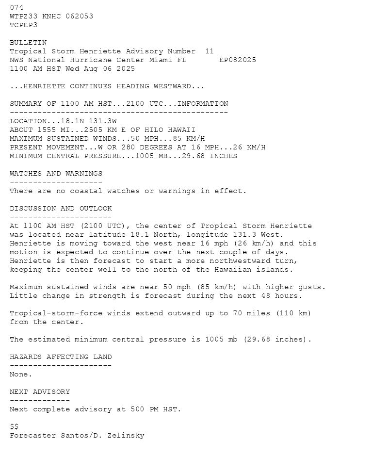
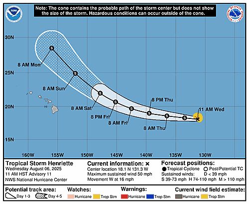
074 WTPZ33 KNHC 062053TCPEP3 BULLETINTropical Storm Henriette Advisory Number 11NWS National Hurricane Center Miami FL EP0820251100 AM HST Wed Aug 06 2025 ...HENRIETTE CONTINUES HEADING WESTWARD... SUMMARY OF 1100 AM HST...2100 UTC...INFORMATION-----------------------------------------------LOCATION...18.1N 131.3WABOUT 1555 MI...2505 KM E OF HILO HAWAIIMAXIMUM SUSTAINED WINDS...50 MPH...85 KM/HPRESENT MOVEMENT...W OR 280 DEGREES AT 16 MPH...26 KM/HMINIMUM CENTRAL PRESSURE...1005 MB...29.68 INCHES WATCHES AND WARNINGS--------------------There are no coastal watches or warnings in effect. DISCUSSION AND OUTLOOK----------------------At 1100 AM HST (2100 UTC), the center of Tropical Storm Henriette was located near latitude 18.1 North, longitude 131.3 West. Henriette is moving toward the west near 16 mph (26 km/h) and this motion is expected to continue over the next couple of days. Henriette is then forecast to start a more northwestward turn, keeping the center well to the north of the Hawaiian islands. Maximum sustained winds are near 50 mph (85 km/h) with higher gusts.Little change in strength is forecast during the next 48 hours. Tropical-storm-force winds extend outward up to 70 miles (110 km)from the center. The estimated minimum central pressure is 1005 mb (29.68 inches). HAZARDS AFFECTING LAND----------------------None. NEXT ADVISORY-------------Next complete advisory at 500 PM HST. $$Forecaster Santos/D. Zelinsky
Tropical Storm Henriette 5-Day Uncertainty Track Image
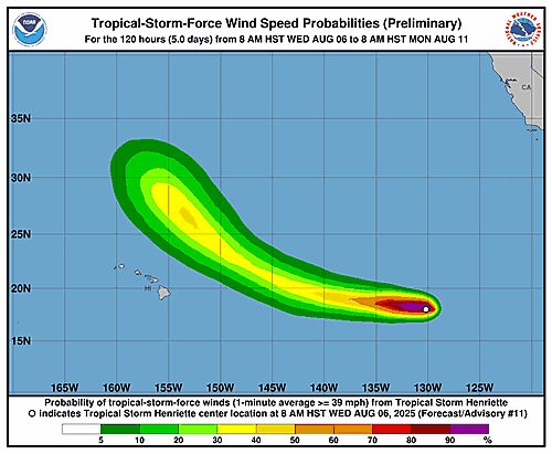
Tropical Storm Henriette 34-Knot Wind Speed Probabilities
Eastern North Pacific Tropical Storm Henriette Advisory Number 11 issued at Wed, 06 Aug 2025 20:53:55 +0000
...HENRIETTE CONTINUES HEADING WESTWARD...
Additional Details Here.
06.08.2025 21:00 — 👍 0 🔁 0 💬 0 📌 0
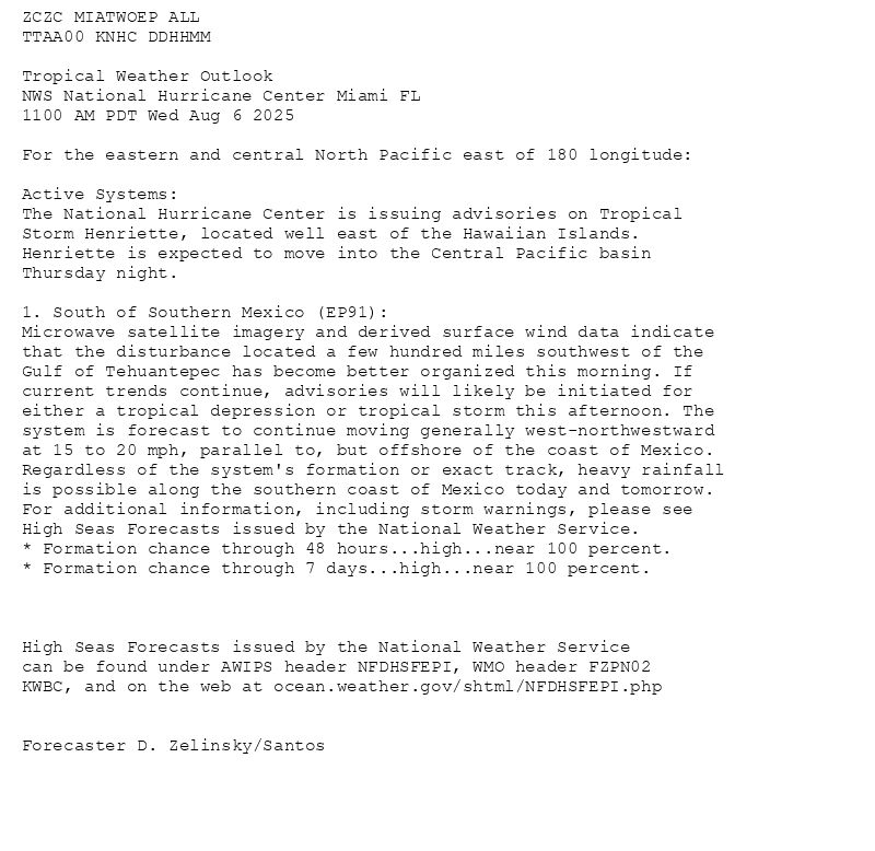
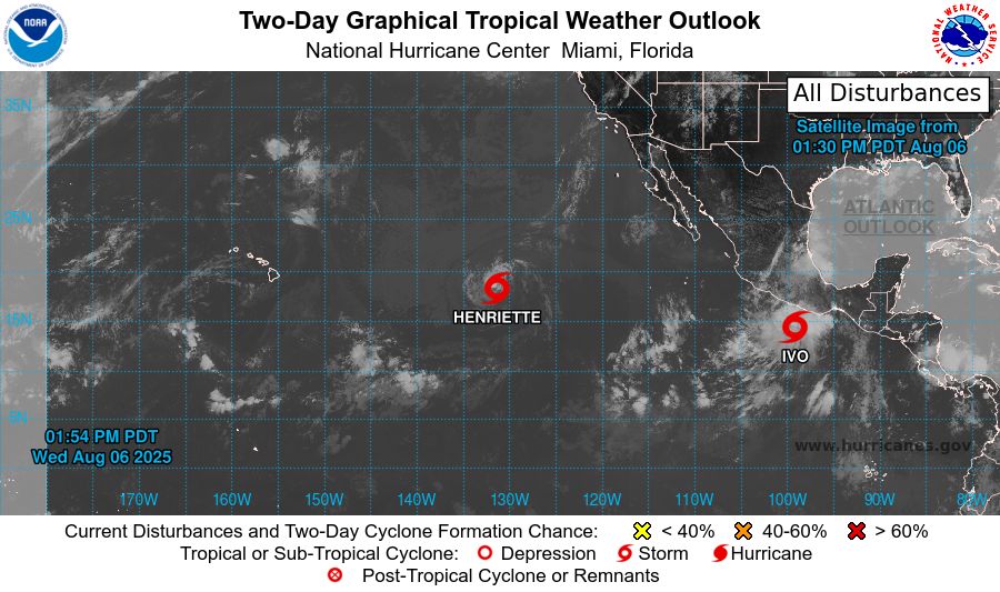
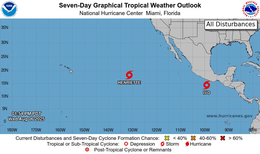
ZCZC MIATWOEP ALL<br>TTAA00 KNHC DDHHMM<br><br>Tropical Weather Outlook<br>NWS National Hurricane Center Miami FL<br>1100 AM PDT Wed Aug 6 2025<br><br>For the eastern and central North Pacific east of 180 longitude:<br><br>Active Systems: <br>The National Hurricane Center is issuing advisories on Tropical <br>Storm Henriette, located well east of the Hawaiian Islands. <br>Henriette is expected to move into the Central Pacific basin <br>Thursday night.<br><br>1. South of Southern Mexico (EP91):<br>Microwave satellite imagery and derived surface wind data indicate <br>that the disturbance located a few hundred miles southwest of the <br>Gulf of Tehuantepec has become better organized this morning. If <br>current trends continue, advisories will likely be initiated for <br>either a tropical depression or tropical storm this afternoon. The <br>system is forecast to continue moving generally west-northwestward <br>at 15 to 20 mph, parallel to, but offshore of the coast of Mexico. <br>Regardless of the system's formation or exact track, heavy rainfall <br>is possible along the southern coast of Mexico today and tomorrow. <br>For additional information, including storm warnings, please see <br>High Seas Forecasts issued by the National Weather Service.<br>* Formation chance through 48 hours...high...near 100 percent.<br>* Formation chance through 7 days...high...near 100 percent.<br><br><br><br>High Seas Forecasts issued by the National Weather Service<br>can be found under AWIPS header NFDHSFEPI, WMO header FZPN02 <br>KWBC, and on the web at ocean.weather.gov/shtml/NFDHSFEPI.php<br><br><br>Forecaster D. Zelinsky/Santos<br><br><br>
Eastern North Pacific 2-Day Graphical Outlook Image
Eastern North Pacific 7-Day Graphical Outlook Image
NHC Eastern North Pacific Outlook update for Wed, 06 Aug 2025 20:54:17 UTC
Additional Details Here.
06.08.2025 21:00 — 👍 0 🔁 0 💬 0 📌 0
ZCZC MIATWOEP ALL<br>TTAA00 KNHC DDHHMM<br><br>Tropical Weather Outlook<br>NWS National Hurricane Center Miami FL<br>1100 AM PDT Wed Aug 6 2025<br><br>For the eastern and central North Pacific east of 180 longitude:<br><br>Active Systems: <br>The National Hurricane Center is issuing advisories on Tropical <br>Storm Henriette, located well east of the Hawaiian Islands. <br>Henriette is expected to move into the Central Pacific basin <br>Thursday night.<br><br>1. South of Southern Mexico (EP91):<br>Microwave satellite imagery and derived surface wind data indicate <br>that the disturbance located a few hundred miles southwest of the <br>Gulf of Tehuantepec has become better organized this morning. If <br>current trends continue, advisories will likely be initiated for <br>either a tropical depression or tropical storm this afternoon. The <br>system is forecast to continue moving generally west-northwestward <br>at 15 to 20 mph, parallel to, but offshore of the coast of Mexico. <br>Regardless of the system's formation or exact track, heavy rainfall <br>is possible along the southern coast of Mexico today and tomorrow. <br>For additional information, including storm warnings, please see <br>High Seas Forecasts issued by the National Weather Service.<br>* Formation chance through 48 hours...high...near 100 percent.<br>* Formation chance through 7 days...high...near 100 percent.<br><br><br><br>High Seas Forecasts issued by the National Weather Service<br>can be found under AWIPS header NFDHSFEPI, WMO header FZPN02 <br>KWBC, and on the web at ocean.weather.gov/shtml/NFDHSFEPI.php<br><br><br>Forecaster D. Zelinsky/Santos<br><br><br>
Eastern North Pacific 2-Day Graphical Outlook Image
Eastern North Pacific 7-Day Graphical Outlook Image
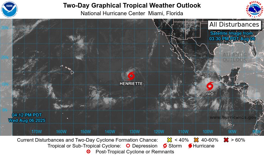
NHC Eastern North Pacific Outlook update for Wed, 06 Aug 2025 17:39:27 UTC
Additional Details Here.
06.08.2025 17:50 — 👍 3 🔁 0 💬 0 📌 0
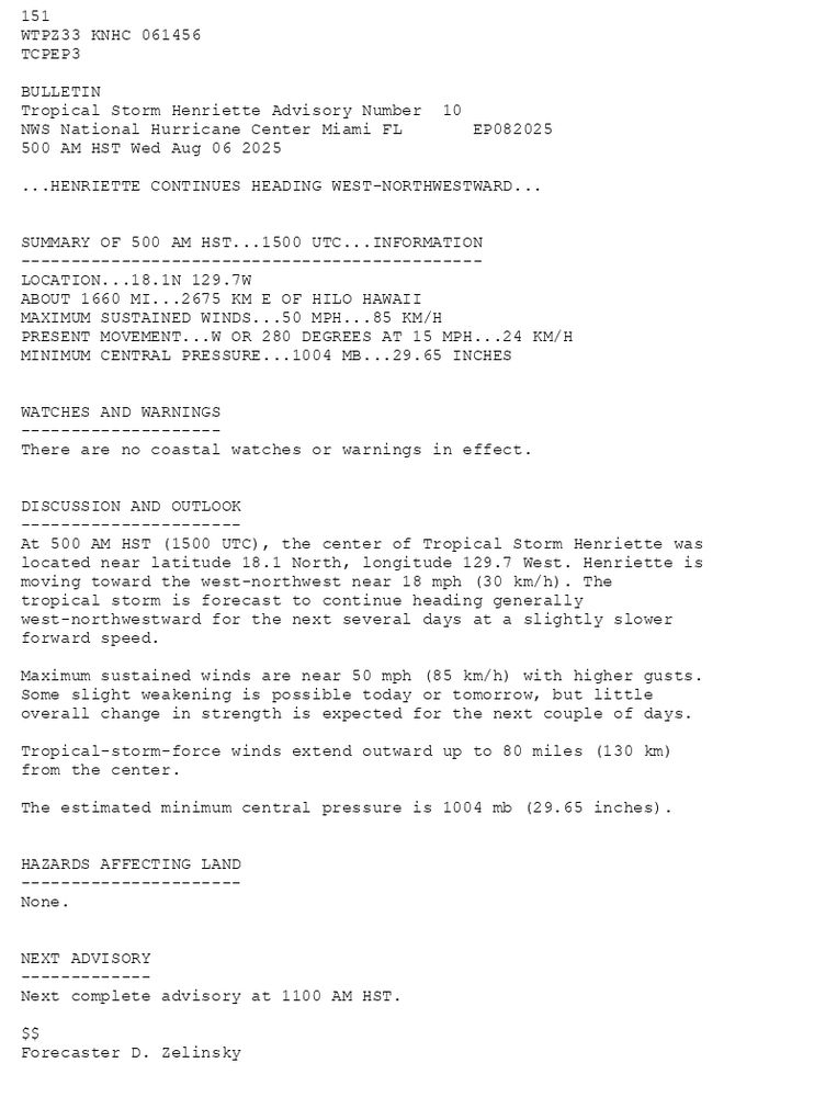
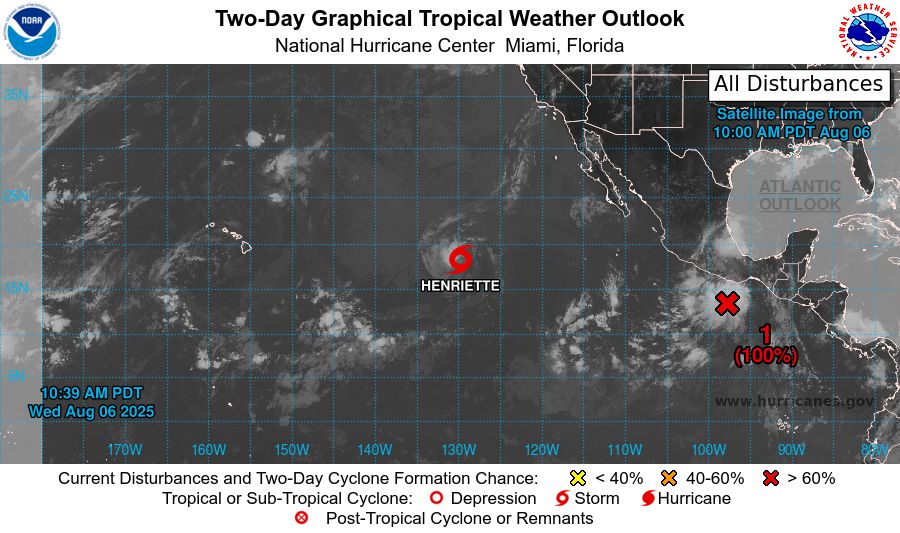
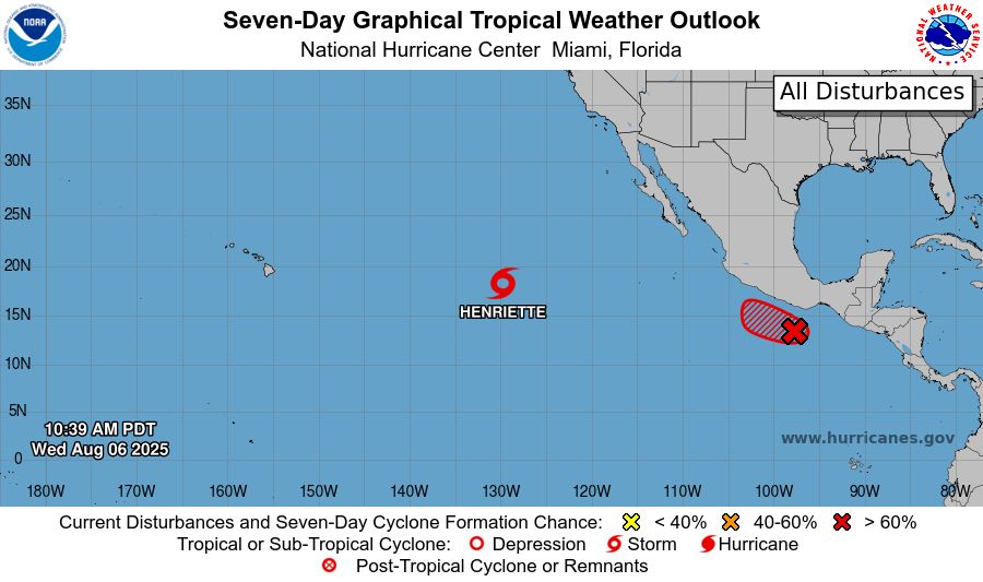
151 WTPZ33 KNHC 061456TCPEP3 BULLETINTropical Storm Henriette Advisory Number 10NWS National Hurricane Center Miami FL EP082025500 AM HST Wed Aug 06 2025 ...HENRIETTE CONTINUES HEADING WEST-NORTHWESTWARD... SUMMARY OF 500 AM HST...1500 UTC...INFORMATION----------------------------------------------LOCATION...18.1N 129.7WABOUT 1660 MI...2675 KM E OF HILO HAWAIIMAXIMUM SUSTAINED WINDS...50 MPH...85 KM/HPRESENT MOVEMENT...W OR 280 DEGREES AT 15 MPH...24 KM/HMINIMUM CENTRAL PRESSURE...1004 MB...29.65 INCHES WATCHES AND WARNINGS--------------------There are no coastal watches or warnings in effect. DISCUSSION AND OUTLOOK----------------------At 500 AM HST (1500 UTC), the center of Tropical Storm Henriette waslocated near latitude 18.1 North, longitude 129.7 West. Henriette ismoving toward the west-northwest near 18 mph (30 km/h). Thetropical storm is forecast to continue heading generallywest-northwestward for the next several days at a slightly slowerforward speed. Maximum sustained winds are near 50 mph (85 km/h) with higher gusts.Some slight weakening is possible today or tomorrow, but littleoverall change in strength is expected for the next couple of days. Tropical-storm-force winds extend outward up to 80 miles (130 km)from the center. The estimated minimum central pressure is 1004 mb (29.65 inches). HAZARDS AFFECTING LAND----------------------None. NEXT ADVISORY-------------Next complete advisory at 1100 AM HST. $$Forecaster D. Zelinsky
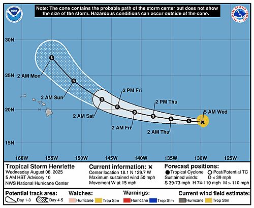
Tropical Storm Henriette 5-Day Uncertainty Track Image
Tropical Storm Henriette 34-Knot Wind Speed Probabilities
Eastern North Pacific Tropical Storm Henriette Advisory Number 10 issued at Wed, 06 Aug 2025 14:56:40 +0000
...HENRIETTE CONTINUES HEADING WEST-NORTHWESTWARD...
Additional Details Here.
06.08.2025 15:00 — 👍 0 🔁 0 💬 0 📌 0
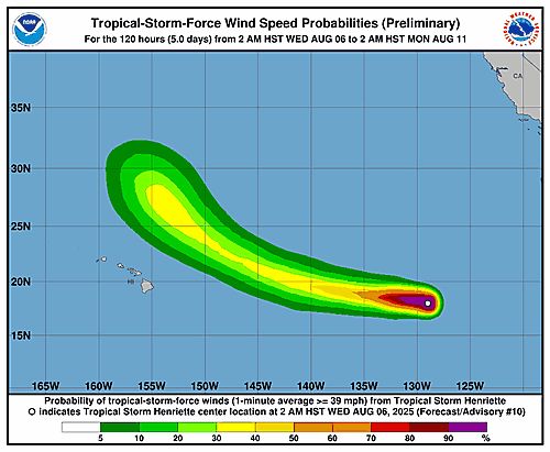
ZCZC MIATWOEP ALL<br>TTAA00 KNHC DDHHMM<br><br>Tropical Weather Outlook<br>NWS National Hurricane Center Miami FL<br>500 AM PDT Wed Aug 6 2025<br><br>For the eastern and central North Pacific east of 180 longitude:<br><br>Active Systems: <br>The National Hurricane Center is issuing advisories on Tropical <br>Storm Henriette, located well east of the Hawaiian Islands. <br>Henriette is expected to move into the Central Pacific basin <br>Thursday night.<br><br>1. South of Southern Mexico (EP91):<br>Shower and thunderstorm activity associated with an area of low <br>pressure located a couple of hundred miles south-southwest of the <br>Gulf of Tehuantepec has increased during the past few hours. <br>Continued development is expected and a tropical depression or <br>tropical storm will likely form during the next day or so. The <br>system is forecast to move generally west-northwestward around 15 <br>mph, parallel to but offshore of the coast of Mexico. For additional <br>information, including gale warnings, please see High Seas Forecasts <br>issued by the National Weather Service.<br>* Formation chance through 48 hours...high...90 percent.<br>* Formation chance through 7 days...high...90 percent.<br><br><br><br>High Seas Forecasts issued by the National Weather Service<br>can be found under AWIPS header NFDHSFEPI, WMO header FZPN02 <br>KWBC, and on the web at ocean.weather.gov/shtml/NFDHSFEPI.php<br><br><br>Forecaster D. Zelinsky/Santos<br><br><br>
Eastern North Pacific 2-Day Graphical Outlook Image
Eastern North Pacific 7-Day Graphical Outlook Image
NHC Eastern North Pacific Outlook update for Wed, 06 Aug 2025 14:56:19 UTC
Additional Details Here.
06.08.2025 15:00 — 👍 0 🔁 0 💬 0 📌 0
ZCZC MIATWOEP ALL<br>TTAA00 KNHC DDHHMM<br><br>Tropical Weather Outlook<br>NWS National Hurricane Center Miami FL<br>500 AM PDT Wed Aug 6 2025<br><br>For the eastern and central North Pacific east of 180 longitude:<br><br>Active Systems: <br>The National Hurricane Center is issuing advisories on Tropical <br>Storm Henriette, located well east of the Hawaiian Islands. <br>Henriette is expected to move into the Central Pacific basin <br>Thursday night.<br><br>1. South of Southern Mexico (EP91):<br>Shower and thunderstorm activity associated with an area of low <br>pressure located a couple of hundred miles south-southwest of the <br>Gulf of Tehuantepec has increased during the past few hours. <br>Continued development is expected and a tropical depression or <br>tropical storm will likely form during the next day or so. The <br>system is forecast to move generally west-northwestward around 15 <br>mph, parallel to but offshore of the coast of Mexico. For additional <br>information, including gale warnings, please see High Seas Forecasts <br>issued by the National Weather Service.<br>* Formation chance through 48 hours...high...90 percent.<br>* Formation chance through 7 days...high...90 percent.<br><br><br><br>High Seas Forecasts issued by the National Weather Service<br>can be found under AWIPS header NFDHSFEPI, WMO header FZPN02 <br>KWBC, and on the web at ocean.weather.gov/shtml/NFDHSFEPI.php<br><br><br>Forecaster D. Zelinsky/Santos<br><br><br>
Eastern North Pacific 2-Day Graphical Outlook Image
Eastern North Pacific 7-Day Graphical Outlook Image
NHC Eastern North Pacific Outlook update for Wed, 06 Aug 2025 11:39:15 UTC
Additional Details Here.
06.08.2025 11:40 — 👍 0 🔁 0 💬 0 📌 0
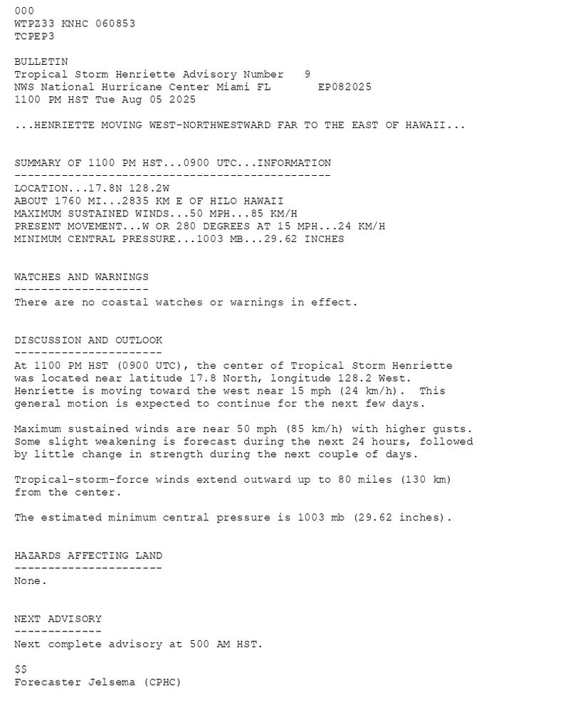
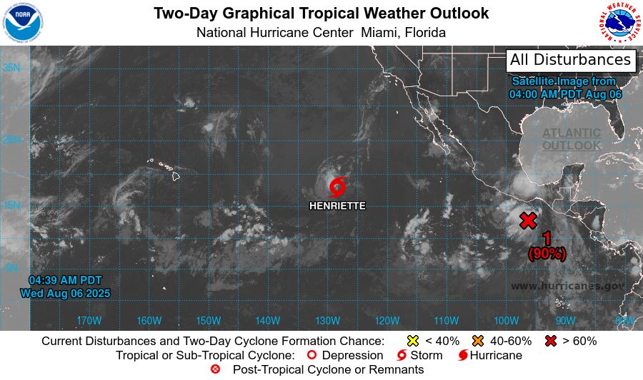
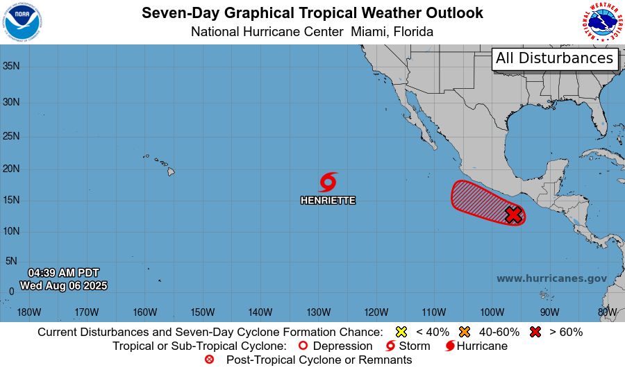
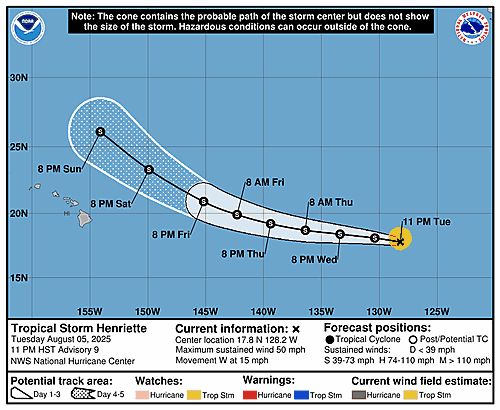
000WTPZ33 KNHC 060853TCPEP3 BULLETINTropical Storm Henriette Advisory Number 9NWS National Hurricane Center Miami FL EP0820251100 PM HST Tue Aug 05 2025 ...HENRIETTE MOVING WEST-NORTHWESTWARD FAR TO THE EAST OF HAWAII... SUMMARY OF 1100 PM HST...0900 UTC...INFORMATION-----------------------------------------------LOCATION...17.8N 128.2WABOUT 1760 MI...2835 KM E OF HILO HAWAIIMAXIMUM SUSTAINED WINDS...50 MPH...85 KM/HPRESENT MOVEMENT...W OR 280 DEGREES AT 15 MPH...24 KM/HMINIMUM CENTRAL PRESSURE...1003 MB...29.62 INCHES WATCHES AND WARNINGS--------------------There are no coastal watches or warnings in effect. DISCUSSION AND OUTLOOK----------------------At 1100 PM HST (0900 UTC), the center of Tropical Storm Henriette was located near latitude 17.8 North, longitude 128.2 West. Henriette is moving toward the west near 15 mph (24 km/h). This general motion is expected to continue for the next few days. Maximum sustained winds are near 50 mph (85 km/h) with higher gusts. Some slight weakening is forecast during the next 24 hours, followed by little change in strength during the next couple of days. Tropical-storm-force winds extend outward up to 80 miles (130 km)from the center. The estimated minimum central pressure is 1003 mb (29.62 inches). HAZARDS AFFECTING LAND----------------------None. NEXT ADVISORY-------------Next complete advisory at 500 AM HST. $$Forecaster Jelsema (CPHC)
Tropical Storm Henriette 5-Day Uncertainty Track Image
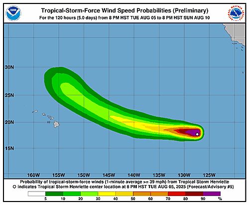
Tropical Storm Henriette 34-Knot Wind Speed Probabilities
Eastern North Pacific Tropical Storm Henriette Advisory Number 9 issued at Wed, 06 Aug 2025 08:53:18 +0000
...HENRIETTE MOVING WEST-NORTHWESTWARD FAR TO THE EAST OF HAWAII...
Additional Details Here.
06.08.2025 09:00 — 👍 0 🔁 0 💬 0 📌 0
ZCZC MIATWOEP ALL<br>TTAA00 KNHC DDHHMM<br><br>Tropical Weather Outlook<br>NWS National Hurricane Center Miami FL<br>1100 PM PDT Tue Aug 5 2025<br><br>For the eastern and central North Pacific east of 180 longitude:<br><br>Active Systems: <br>The National Hurricane Center is issuing advisories on Tropical <br>Storm Henriette, located well east of the Hawaiian Islands. <br>Henriette is expected to move into the Central Pacific basin <br>Thursday night.<br><br>1. South of Southern Mexico (EP91):<br>Showers and thunderstorms associated with an area of low pressure <br>located a few hundred miles south of the Gulf of Tehuantepec <br>continue to show signs of organization. Environmental conditions <br>are conducive for development of this system, and a tropical <br>depression is expected to form during the next day or two while the <br>low moves west-northwestward around 15 mph. For additional <br>information, including gale warnings, please see High Seas Forecasts <br>issued by the National Weather Service.<br>* Formation chance through 48 hours...high...90 percent.<br>* Formation chance through 7 days...high...90 percent.<br><br><br><br><br>High Seas Forecasts issued by the National Weather Service<br>can be found under AWIPS header NFDHSFEPI, WMO header FZPN02 <br>KWBC, and on the web at ocean.weather.gov/shtml/NFDHSFEPI.php<br><br><br>Forecaster Jelsema<br><br><br>
Eastern North Pacific 2-Day Graphical Outlook Image

Eastern North Pacific 7-Day Graphical Outlook Image
NHC Eastern North Pacific Outlook update for Wed, 06 Aug 2025 08:53:18 UTC
Additional Details Here.
06.08.2025 09:00 — 👍 0 🔁 0 💬 0 📌 0
ZCZC MIATWOEP ALL<br>TTAA00 KNHC DDHHMM<br><br>Tropical Weather Outlook<br>NWS National Hurricane Center Miami FL<br>1100 PM PDT Tue Aug 5 2025<br><br>For the eastern and central North Pacific east of 180 longitude:<br><br>Active Systems: <br>The National Hurricane Center is issuing advisories on Tropical <br>Storm Henriette, located well east of the Hawaiian Islands. <br>Henriette is expected to move into the Central Pacific basin <br>Thursday night.<br><br>1. South of Southern Mexico (EP91):<br>Showers and thunderstorms associated with an area of low pressure <br>located a few hundred miles south of the Gulf of Tehuantepec <br>continue to show signs of organization. Environmental conditions <br>are conducive for development of this system, and a tropical <br>depression is expected to form during the next day or two while the <br>low moves west-northwestward around 15 mph. For additional <br>information, including gale warnings, please see High Seas Forecasts <br>issued by the National Weather Service.<br>* Formation chance through 48 hours...high...90 percent.<br>* Formation chance through 7 days...high...90 percent.<br><br><br><br><br>High Seas Forecasts issued by the National Weather Service<br>can be found under AWIPS header NFDHSFEPI, WMO header FZPN02 <br>KWBC, and on the web at ocean.weather.gov/shtml/NFDHSFEPI.php<br><br><br>Forecaster Jelsema<br><br><br>
Eastern North Pacific 2-Day Graphical Outlook Image

Eastern North Pacific 7-Day Graphical Outlook Image
NHC Eastern North Pacific Outlook update for Wed, 06 Aug 2025 05:20:46 UTC
Additional Details Here.
06.08.2025 05:30 — 👍 0 🔁 0 💬 0 📌 0
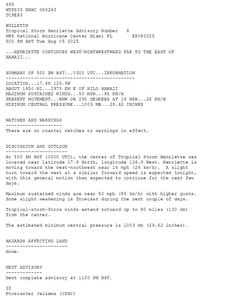
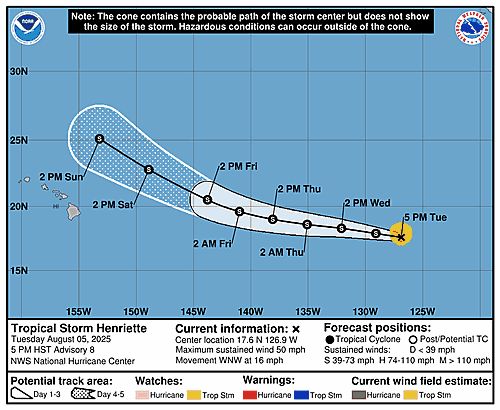
695 WTPZ33 KNHC 060243TCPEP3 BULLETINTropical Storm Henriette Advisory Number 8NWS National Hurricane Center Miami FL EP082025500 PM HST Tue Aug 05 2025 ...HENRIETTE CONTINUES WEST-NORTHWESTWARD FAR TO THE EAST OFHAWAII... SUMMARY OF 500 PM HST...0300 UTC...INFORMATION----------------------------------------------LOCATION...17.6N 126.9WABOUT 1850 MI...2975 KM E OF HILO HAWAIIMAXIMUM SUSTAINED WINDS...50 MPH...85 KM/HPRESENT MOVEMENT...WNW OR 290 DEGREES AT 16 MPH...26 KM/HMINIMUM CENTRAL PRESSURE...1003 MB...29.62 INCHES WATCHES AND WARNINGS--------------------There are no coastal watches or warnings in effect. DISCUSSION AND OUTLOOK----------------------At 500 PM HST (0300 UTC), the center of Tropical Storm Henriette waslocated near latitude 17.6 North, longitude 126.9 West. Henriette is moving toward the west-northwest near 16 mph (26 km/h). A slight turn toward the west at a similar forward speed is expected tonight, with this general motion then expected to continue for the next few days. Maximum sustained winds are near 50 mph (85 km/h) with higher gusts.Some slight weakening is forecast during the next couple of days. Tropical-storm-force winds extend outward up to 80 miles (130 km)from the center. The estimated minimum central pressure is 1003 mb (29.62 inches). HAZARDS AFFECTING LAND----------------------None. NEXT ADVISORY-------------Next complete advisory at 1100 PM HST. $$Forecaster Jelsema (CPHC)
Tropical Storm Henriette 5-Day Uncertainty Track Image
Tropical Storm Henriette 34-Knot Wind Speed Probabilities
Eastern North Pacific Tropical Storm Henriette Advisory Number 8 issued at Wed, 06 Aug 2025 02:43:35 +0000
...HENRIETTE CONTINUES WEST-NORTHWESTWARD FAR TO THE EAST OF HAWAII...
Additional Details Here.
06.08.2025 02:50 — 👍 0 🔁 0 💬 0 📌 0
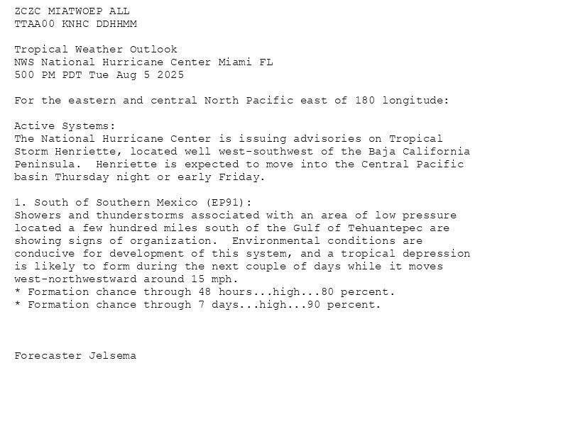
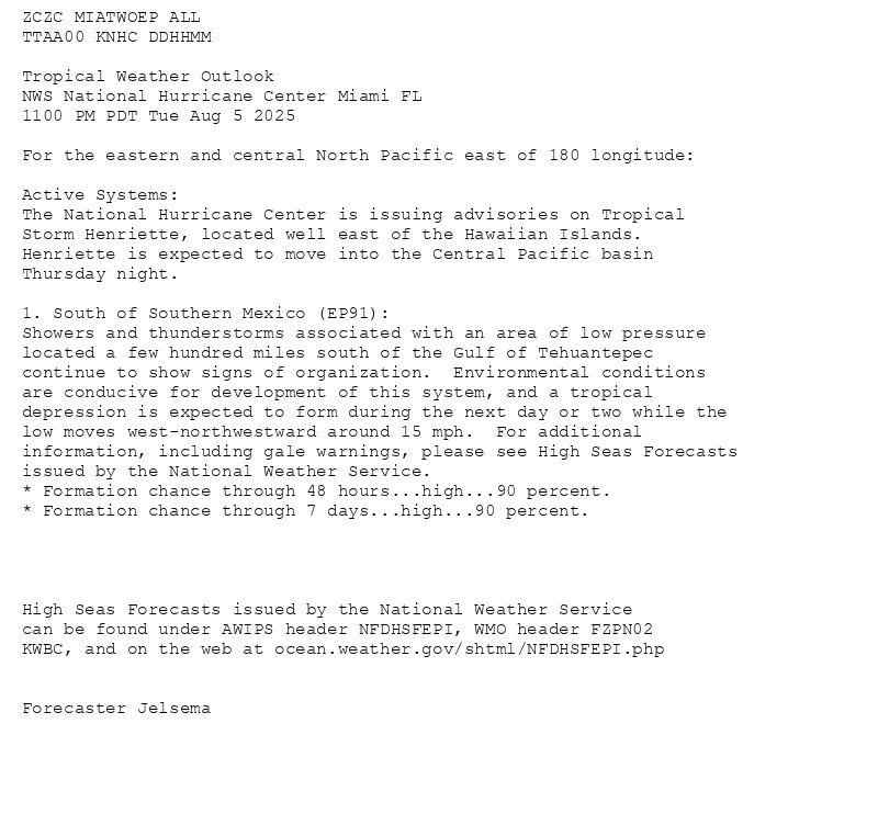
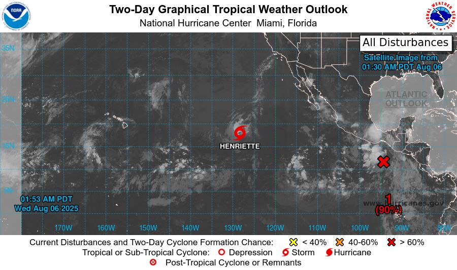
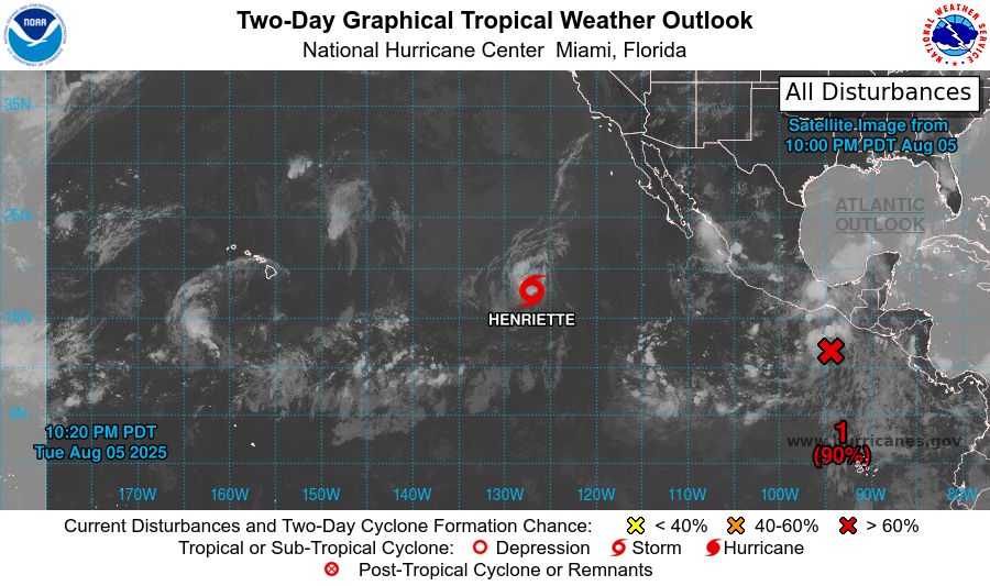
ZCZC MIATWOEP ALL<br>TTAA00 KNHC DDHHMM<br><br>Tropical Weather Outlook<br>NWS National Hurricane Center Miami FL<br>500 PM PDT Tue Aug 5 2025<br><br>For the eastern and central North Pacific east of 180 longitude:<br><br>Active Systems: <br>The National Hurricane Center is issuing advisories on Tropical <br>Storm Henriette, located well west-southwest of the Baja California <br>Peninsula. Henriette is expected to move into the Central Pacific <br>basin Thursday night or early Friday.<br><br>1. South of Southern Mexico (EP91):<br>Showers and thunderstorms associated with an area of low pressure <br>located a few hundred miles south of the Gulf of Tehuantepec are <br>showing signs of organization. Environmental conditions are <br>conducive for development of this system, and a tropical depression <br>is likely to form during the next couple of days while it moves <br>west-northwestward around 15 mph.<br>* Formation chance through 48 hours...high...80 percent.<br>* Formation chance through 7 days...high...90 percent.<br><br><br><br>Forecaster Jelsema<br><br><br>
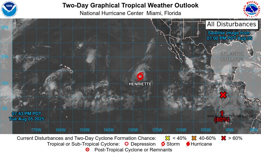
Eastern North Pacific 2-Day Graphical Outlook Image

Eastern North Pacific 7-Day Graphical Outlook Image
NHC Eastern North Pacific Outlook update for Wed, 06 Aug 2025 02:43:17 UTC
Additional Details Here.
06.08.2025 02:50 — 👍 0 🔁 0 💬 0 📌 0