The Storm Prediction Center issues Day 2 Marginal Convective Risk at Aug 4, 17:24z for portions of MPX
at Mon, 04 Aug 2025 17:27:41 +0000 via IEMbot
Additional Details Here.
04.08.2025 17:28 — 👍 0 🔁 0 💬 0 📌 0
MPX issues Area Forecast Discussion (AFD) at Aug 4, 12:00 PM CDT
at Mon, 04 Aug 2025 17:01:00 +0000 via IEMbot
Additional Details Here.
04.08.2025 17:08 — 👍 0 🔁 0 💬 0 📌 0
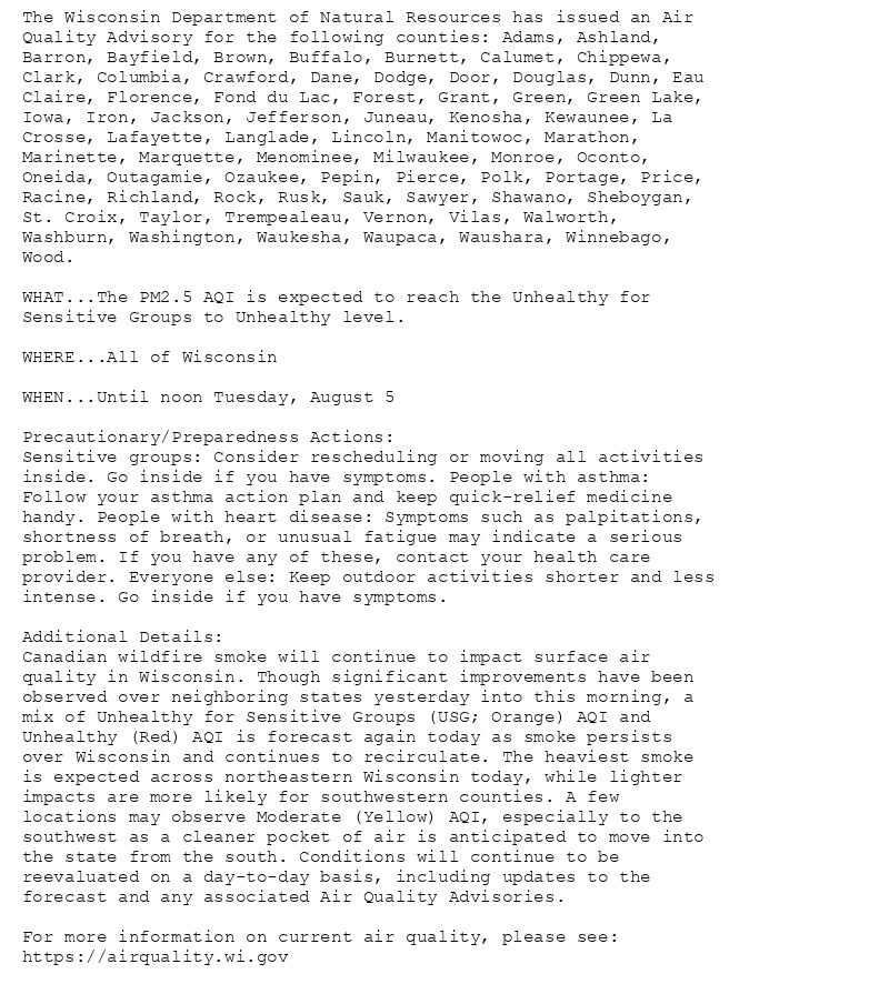
The Wisconsin Department of Natural Resources has issued an Air
Quality Advisory for the following counties: Adams, Ashland,
Barron, Bayfield, Brown, Buffalo, Burnett, Calumet, Chippewa,
Clark, Columbia, Crawford, Dane, Dodge, Door, Douglas, Dunn, Eau
Claire, Florence, Fond du Lac, Forest, Grant, Green, Green Lake,
Iowa, Iron, Jackson, Jefferson, Juneau, Kenosha, Kewaunee, La
Crosse, Lafayette, Langlade, Lincoln, Manitowoc, Marathon,
Marinette, Marquette, Menominee, Milwaukee, Monroe, Oconto,
Oneida, Outagamie, Ozaukee, Pepin, Pierce, Polk, Portage, Price,
Racine, Richland, Rock, Rusk, Sauk, Sawyer, Shawano, Sheboygan,
St. Croix, Taylor, Trempealeau, Vernon, Vilas, Walworth,
Washburn, Washington, Waukesha, Waupaca, Waushara, Winnebago,
Wood.
WHAT...The PM2.5 AQI is expected to reach the Unhealthy for
Sensitive Groups to Unhealthy level.
WHERE...All of Wisconsin
WHEN...Until noon Tuesday, August 5
Precautionary/Preparedness Actions:
Sensitive groups: Consider rescheduling or moving all activities
inside. Go inside if you have symptoms. People with asthma:
Follow your asthma action plan and keep quick-relief medicine
handy. People with heart disease: Symptoms such as palpitations,
shortness of breath, or unusual fatigue may indicate a serious
problem. If you have any of these, contact your health care
provider. Everyone else: Keep outdoor activities shorter and less
intense. Go inside if you have symptoms.
Additional Details:
Canadian wildfire smoke will continue to impact surface air
quality in Wisconsin. Though significant improvements have been
observed over neighboring states yesterday into this morning, a
mix of Unhealthy for Sensitive Groups (USG; Orange) AQI and
Unhealthy (Red) AQI is forecast again today as smoke persists
over Wisconsin and continues to recirculate. The heaviest smoke
is expected across northeastern Wisconsin today, while lighter
impacts are more likely for southwestern counties. A few
locations may observe Moderate (Yellow) AQI, especially to the
southwest as a cleaner pocket of air is anticipated to move into
the state from the south. Conditions will continue to be
reevaluated on a day-to-day basis, including updates to the
forecast and any associated Air Quality Advisories.
For more information on current air quality, please see:
https://airquality.wi.gov
Air Quality Alert issued August 4 at 10:25AM CDT by NWS Twin Cities/Chanhassen MN
Additional Details Here.
04.08.2025 15:30 — 👍 1 🔁 1 💬 0 📌 0
MPX issues Air Quality Alert (AQA) at Aug 4, 10:25 AM CDT
at Mon, 04 Aug 2025 15:25:27 +0000 via IEMbot
Additional Details Here.
04.08.2025 15:28 — 👍 0 🔁 0 💬 0 📌 0
MPX issues Area Forecast Discussion (AFD) at Aug 4, 6:02 AM CDT
at Mon, 04 Aug 2025 11:04:11 +0000 via IEMbot
Additional Details Here.
04.08.2025 11:08 — 👍 0 🔁 0 💬 0 📌 0
The Storm Prediction Center issues Day 5 15% Any Severe Convective Risk at Aug 4, 9:03z for portions of MPX
at Mon, 04 Aug 2025 09:05:07 +0000 via IEMbot
Additional Details Here.
04.08.2025 09:08 — 👍 0 🔁 0 💬 0 📌 0
MPX issues Area Forecast Discussion (AFD) at Aug 4, 3:35 AM CDT
at Mon, 04 Aug 2025 08:36:01 +0000 via IEMbot
Additional Details Here.
04.08.2025 08:48 — 👍 0 🔁 0 💬 0 📌 0
MPX issues Hazardous Weather Outlook (HWO) at Aug 4, 2:45 AM CDT
at Mon, 04 Aug 2025 07:46:41 +0000 via IEMbot
Additional Details Here.
04.08.2025 07:48 — 👍 0 🔁 0 💬 0 📌 0
The Storm Prediction Center issues Day 3 Marginal Convective Risk at Aug 4, 7:16z for portions of MPX
at Mon, 04 Aug 2025 07:17:15 +0000 via IEMbot
Additional Details Here.
04.08.2025 07:28 — 👍 0 🔁 0 💬 0 📌 0
EAU CLAIRE WI Aug 3
Climate Report:
High: 79
Low: 49
Precip: 0.0"
Snow: 0.0" Snow Depth: 0"
at Mon, 04 Aug 2025 06:40:56 +0000 via IEMbot
Additional Details Here.
04.08.2025 06:48 — 👍 0 🔁 0 💬 0 📌 0
MPX issues Area Forecast Discussion (AFD) at Aug 4, 12:46 AM CDT
at Mon, 04 Aug 2025 05:47:09 +0000 via IEMbot
Additional Details Here.
04.08.2025 05:48 — 👍 0 🔁 0 💬 0 📌 0
MPX continues Flood Warning for Minnesota River at Montevideo [MN] until further notice
at Mon, 04 Aug 2025 01:58:54 +0000 via IEMbot
Additional Details Here.
04.08.2025 02:08 — 👍 0 🔁 0 💬 0 📌 0
MPX continues Flood Warning for Minnesota River at Morton [MN] until further notice
at Mon, 04 Aug 2025 01:58:54 +0000 via IEMbot
Additional Details Here.
04.08.2025 02:08 — 👍 0 🔁 0 💬 0 📌 0
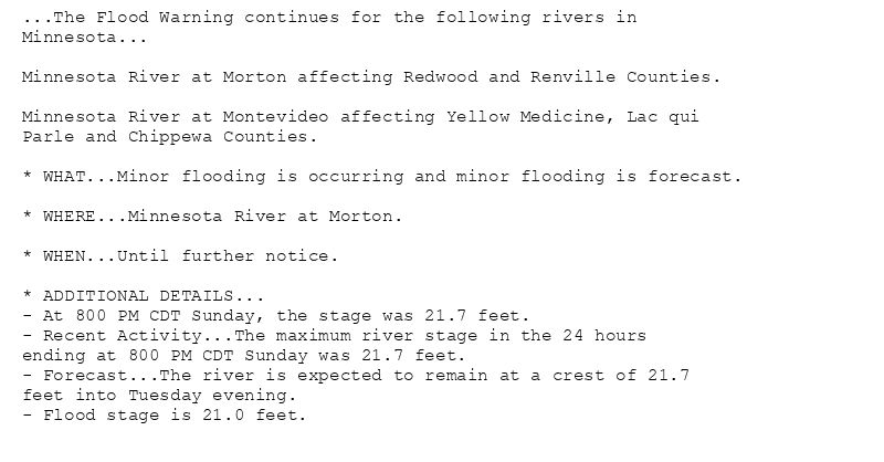
...The Flood Warning continues for the following rivers in
Minnesota...
Minnesota River at Morton affecting Redwood and Renville Counties.
Minnesota River at Montevideo affecting Yellow Medicine, Lac qui
Parle and Chippewa Counties.
* WHAT...Minor flooding is occurring and minor flooding is forecast.
* WHERE...Minnesota River at Morton.
* WHEN...Until further notice.
* ADDITIONAL DETAILS...
- At 800 PM CDT Sunday, the stage was 21.7 feet.
- Recent Activity...The maximum river stage in the 24 hours
ending at 800 PM CDT Sunday was 21.7 feet.
- Forecast...The river is expected to remain at a crest of 21.7
feet into Tuesday evening.
- Flood stage is 21.0 feet.
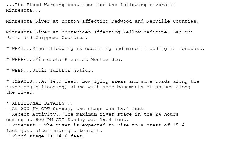
...The Flood Warning continues for the following rivers in
Minnesota...
Minnesota River at Morton affecting Redwood and Renville Counties.
Minnesota River at Montevideo affecting Yellow Medicine, Lac qui
Parle and Chippewa Counties.
* WHAT...Minor flooding is occurring and minor flooding is forecast.
* WHERE...Minnesota River at Montevideo.
* WHEN...Until further notice.
* IMPACTS...At 14.0 feet, Low lying areas and some roads along the
river begin flooding, along with some basements of houses along
the river.
* ADDITIONAL DETAILS...
- At 800 PM CDT Sunday, the stage was 15.4 feet.
- Recent Activity...The maximum river stage in the 24 hours
ending at 800 PM CDT Sunday was 15.4 feet.
- Forecast...The river is expected to rise to a crest of 15.4
feet just after midnight tonight.
- Flood stage is 14.0 feet.
🚨 Flood Warning issued August 3 at 8:58PM CDT by NWS Twin Cities/Chanhassen MN 🚨
Additional Details Here.
04.08.2025 02:00 — 👍 1 🔁 0 💬 0 📌 0
MPX issues Air Quality Alert (AQA) at Aug 3, 7:46 PM CDT ...AIR QUALITY ALERT IS CANCELLED... via IEMbot
Additional Details Here.
04.08.2025 01:08 — 👍 0 🔁 1 💬 0 📌 0
MPX issues Air Quality Alert (AQA) at Aug 3, 7:31 PM CDT ...AIR QUALITY ALERT IS CANCELLED... via IEMbot
Additional Details Here.
04.08.2025 00:49 — 👍 13 🔁 7 💬 0 📌 2
EAU CLAIRE WI Aug 3
Climate Report:
High: 79
Low: 49
Precip: 0.0"
Snow: 0.0" Snow Depth: 0"
at Mon, 04 Aug 2025 00:34:39 +0000 via IEMbot
Additional Details Here.
04.08.2025 00:49 — 👍 0 🔁 0 💬 0 📌 0
MPX issues Area Forecast Discussion (AFD) at Aug 3, 6:30 PM CDT
at Sun, 03 Aug 2025 23:30:22 +0000 via IEMbot
Additional Details Here.
03.08.2025 23:48 — 👍 0 🔁 0 💬 0 📌 0
CHANHASSEN MN Aug 3
Climate Report:
High: 75
Low: 60
Precip: 0.0"
Snow: 0.0" Snow Depth: 0"
at Sun, 03 Aug 2025 21:29:50 +0000 via IEMbot
Additional Details Here.
03.08.2025 21:49 — 👍 0 🔁 0 💬 0 📌 0
MPX issues Hazardous Weather Outlook (HWO) at Aug 3, 2:54 PM CDT
at Sun, 03 Aug 2025 19:54:19 +0000 via IEMbot
Additional Details Here.
03.08.2025 20:08 — 👍 0 🔁 0 💬 0 📌 0
MPX issues Area Forecast Discussion (AFD) at Aug 3, 2:15 PM CDT
at Sun, 03 Aug 2025 19:16:22 +0000 via IEMbot
Additional Details Here.
03.08.2025 19:28 — 👍 0 🔁 0 💬 0 📌 0
The Storm Prediction Center issues Day 3 Marginal Convective Risk at Aug 3, 18:29z for portions of MPX
at Sun, 03 Aug 2025 18:30:36 +0000 via IEMbot
Additional Details Here.
03.08.2025 18:48 — 👍 0 🔁 0 💬 0 📌 0
MPX issues Area Forecast Discussion (AFD) at Aug 3, 12:32 PM CDT
at Sun, 03 Aug 2025 17:34:16 +0000 via IEMbot
Additional Details Here.
03.08.2025 17:48 — 👍 0 🔁 0 💬 0 📌 0
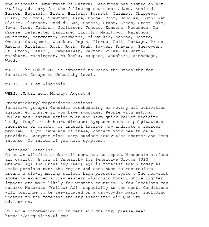
The Wisconsin Department of Natural Resources has issued an Air
Quality Advisory for the following counties: Adams, Ashland,
Barron, Bayfield, Brown, Buffalo, Burnett, Calumet, Chippewa,
Clark, Columbia, Crawford, Dane, Dodge, Door, Douglas, Dunn, Eau
Claire, Florence, Fond du Lac, Forest, Grant, Green, Green Lake,
Iowa, Iron, Jackson, Jefferson, Juneau, Kenosha, Kewaunee, La
Crosse, Lafayette, Langlade, Lincoln, Manitowoc, Marathon,
Marinette, Marquette, Menominee, Milwaukee, Monroe, Oconto,
Oneida, Outagamie, Ozaukee, Pepin, Pierce, Polk, Portage, Price,
Racine, Richland, Rock, Rusk, Sauk, Sawyer, Shawano, Sheboygan,
St. Croix, Taylor, Trempealeau, Vernon, Vilas, Walworth,
Washburn, Washington, Waukesha, Waupaca, Waushara, Winnebago,
Wood.
WHAT...The PM2.5 AQI is expected to reach the Unhealthy for
Sensitive Groups to Unhealthy level.
WHERE...All of Wisconsin
WHEN...Until noon Monday, August 4
Precautionary/Preparedness Actions:
Sensitive groups: Consider rescheduling or moving all activities
inside. Go inside if you have symptoms. People with asthma:
Follow your asthma action plan and keep quick-relief medicine
handy. People with heart disease: Symptoms such as palpitations,
shortness of breath, or unusual fatigue may indicate a serious
problem. If you have any of these, contact your health care
provider. Everyone else: Keep outdoor activities shorter and less
intense. Go inside if you have symptoms.
Additional Details:
Canadian wildfire smoke will continue to impact Wisconsin surface
air quality. A mix of Unhealthy for Sensitive Groups (USG;
Orange) AQI and Unhealthy (Red) AQI is forecast again today as
smoke persists over the region and continues to recirculate
around a slowly moving surface high pressure system. The heaviest
smoke is expected across eastern Wisconsin today, while lighter
impacts are more likely for western counties. A few locations may
observe Moderate (Yellow) AQI, especially to the west. Conditions
will continue to be reevaluated on a day-to-day basis, including
updates to the forecast and any associated Air Quality
Advisories.
For more information on current air quality, please see:
https://airquality.wi.gov
Air Quality Alert issued August 3 at 10:21AM CDT by NWS Twin Cities/Chanhassen MN
Additional Details Here.
03.08.2025 15:30 — 👍 1 🔁 0 💬 0 📌 0
MPX issues Air Quality Alert (AQA) at Aug 3, 10:21 AM CDT
at Sun, 03 Aug 2025 15:22:10 +0000 via IEMbot
Additional Details Here.
03.08.2025 15:28 — 👍 0 🔁 0 💬 0 📌 0
MPX continues Flood Warning for Minnesota River at Montevideo [MN] until further notice
at Sun, 03 Aug 2025 14:14:46 +0000 via IEMbot
Additional Details Here.
03.08.2025 14:28 — 👍 0 🔁 0 💬 0 📌 0
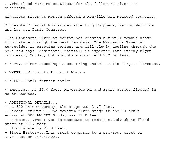
...The Flood Warning continues for the following rivers in
Minnesota...
Minnesota River at Morton affecting Renville and Redwood Counties.
Minnesota River at Montevideo affecting Chippewa, Yellow Medicine
and Lac qui Parle Counties.
.The Minnesota River at Morton has crested but will remain above
flood stage through the next few days. The Minnesota River at
Montevideo is cresting tonight and will slowly decline through the
next few days. Additional rainfall is expected late Sunday night
into early Monday, but amounts should be 0.25" or less.
* WHAT...Minor flooding is occurring and minor flooding is forecast.
* WHERE...Minnesota River at Morton.
* WHEN...Until further notice.
* IMPACTS...At 23.0 feet, Riverside Rd and Front Street flooded in
North Redwood.
* ADDITIONAL DETAILS...
- At 800 AM CDT Sunday, the stage was 21.7 feet.
- Recent Activity...The maximum river stage in the 24 hours
ending at 800 AM CDT Sunday was 21.8 feet.
- Forecast...The river is expected to remain steady above flood
stage at 21.7 feet.
- Flood stage is 21.0 feet.
- Flood History...This crest compares to a previous crest of
21.9 feet on 04/04/2007.
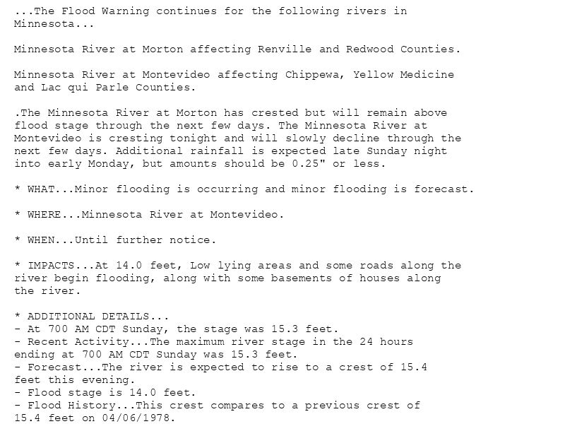
...The Flood Warning continues for the following rivers in
Minnesota...
Minnesota River at Morton affecting Renville and Redwood Counties.
Minnesota River at Montevideo affecting Chippewa, Yellow Medicine
and Lac qui Parle Counties.
.The Minnesota River at Morton has crested but will remain above
flood stage through the next few days. The Minnesota River at
Montevideo is cresting tonight and will slowly decline through the
next few days. Additional rainfall is expected late Sunday night
into early Monday, but amounts should be 0.25" or less.
* WHAT...Minor flooding is occurring and minor flooding is forecast.
* WHERE...Minnesota River at Montevideo.
* WHEN...Until further notice.
* IMPACTS...At 14.0 feet, Low lying areas and some roads along the
river begin flooding, along with some basements of houses along
the river.
* ADDITIONAL DETAILS...
- At 700 AM CDT Sunday, the stage was 15.3 feet.
- Recent Activity...The maximum river stage in the 24 hours
ending at 700 AM CDT Sunday was 15.3 feet.
- Forecast...The river is expected to rise to a crest of 15.4
feet this evening.
- Flood stage is 14.0 feet.
- Flood History...This crest compares to a previous crest of
15.4 feet on 04/06/1978.
🚨 Flood Warning issued August 3 at 9:14AM CDT by NWS Twin Cities/Chanhassen MN 🚨
Additional Details Here.
03.08.2025 14:15 — 👍 0 🔁 0 💬 0 📌 0
MPX issues Area Forecast Discussion (AFD) at Aug 3, 6:05 AM CDT
at Sun, 03 Aug 2025 11:06:07 +0000 via IEMbot
Additional Details Here.
03.08.2025 11:08 — 👍 0 🔁 0 💬 0 📌 0
MPX issues Area Forecast Discussion (AFD) at Aug 3, 4:04 AM CDT
at Sun, 03 Aug 2025 09:04:37 +0000 via IEMbot
Additional Details Here.
03.08.2025 09:08 — 👍 0 🔁 0 💬 0 📌 0
Weather Prediction Center issues Mesoscale Precipitation Discussion #859 concerning HEAVY RAINFALL...FLASH FLOODING LIKELY
at Sun, 03 Aug 2025 08:04:08 +0000 via IEMbot
Additional Details Here.
03.08.2025 08:08 — 👍 0 🔁 0 💬 0 📌 0