STOCKTON AIRPORT CA Aug 4
Climate Report:
High: 90
Low: 59
Precip: 0.0"
Snow: Missing
at Tue, 05 Aug 2025 08:51:22 +0000 via IEMbot
Additional Details Here.
05.08.2025 09:08 — 👍 0 🔁 0 💬 0 📌 0
REDDING CA AIRPORT AND CITY Aug 4
Climate Report:
High: 93
Low: 62
Precip: 0.0"
Snow: Missing
at Tue, 05 Aug 2025 08:51:24 +0000 via IEMbot
Additional Details Here.
05.08.2025 09:08 — 👍 0 🔁 0 💬 0 📌 0
SACRAMENTO EXEC AP AND CITY Aug 4
Climate Report:
High: 90
Low: 59
Precip: 0.0"
Snow: Missing
at Tue, 05 Aug 2025 00:29:27 +0000 via IEMbot
Additional Details Here.
05.08.2025 00:48 — 👍 0 🔁 1 💬 0 📌 0
MODESTO CA Aug 4
Climate Report:
High: 90
Low: 60
Precip: 0.0"
Snow: Missing
at Tue, 05 Aug 2025 00:29:31 +0000 via IEMbot
Additional Details Here.
05.08.2025 00:48 — 👍 0 🔁 0 💬 0 📌 0
STO issues Area Forecast Discussion (AFD) at Aug 4, 1:00 PM PDT
at Mon, 04 Aug 2025 20:00:59 +0000 via IEMbot
Additional Details Here.
04.08.2025 20:08 — 👍 0 🔁 0 💬 0 📌 0
STOCKTON AIRPORT CA Aug 3
Climate Report:
High: 93
Low: 58
Precip: 0.0"
Snow: Missing
at Mon, 04 Aug 2025 08:52:46 +0000 via IEMbot
Additional Details Here.
04.08.2025 09:08 — 👍 0 🔁 0 💬 0 📌 0
MODESTO CA Aug 3
Climate Report:
High: 93
Low: 62
Precip: 0.0"
Snow: Missing
at Mon, 04 Aug 2025 00:29:04 +0000 via IEMbot
Additional Details Here.
04.08.2025 00:49 — 👍 0 🔁 0 💬 0 📌 0
STOCKTON AIRPORT CA Aug 3
Climate Report:
High: 93
Low: 58
Precip: 0.0"
Snow: Missing
at Mon, 04 Aug 2025 00:29:07 +0000 via IEMbot
Additional Details Here.
04.08.2025 00:49 — 👍 0 🔁 0 💬 0 📌 0
STO issues Area Forecast Discussion (AFD) at Aug 3, 1:37 PM PDT
at Sun, 03 Aug 2025 20:37:44 +0000 via IEMbot
Additional Details Here.
03.08.2025 20:48 — 👍 0 🔁 0 💬 0 📌 0
The Storm Prediction Center issues Day 1 Isolated Dry Thunderstorm Fire Weather Risk at Aug 3, 16:41z for portions of STO
at Sun, 03 Aug 2025 16:42:35 +0000 via IEMbot
Additional Details Here.
03.08.2025 16:48 — 👍 0 🔁 0 💬 0 📌 0
STOCKTON AIRPORT CA Aug 2
Climate Report:
High: 94
Low: 60
Precip: 0.0"
Snow: Missing
at Sun, 03 Aug 2025 08:51:39 +0000 via IEMbot
Additional Details Here.
03.08.2025 09:08 — 👍 0 🔁 0 💬 0 📌 0
MODESTO CA Aug 2
Climate Report:
High: 93
Low: 63
Precip: 0.0"
Snow: Missing
at Sun, 03 Aug 2025 08:51:39 +0000 via IEMbot
Additional Details Here.
03.08.2025 09:08 — 👍 0 🔁 0 💬 0 📌 0
The Storm Prediction Center issues Day 1 Isolated Dry Thunderstorm Fire Weather Risk at Aug 3, 7:01z for portions of STO
at Sun, 03 Aug 2025 07:02:01 +0000 via IEMbot
Additional Details Here.
03.08.2025 07:08 — 👍 0 🔁 0 💬 0 📌 0
SACRAMENTO EXEC AP AND CITY Aug 2
Climate Report:
High: 92
Low: 57
Precip: 0.0"
Snow: Missing
at Sun, 03 Aug 2025 00:29:18 +0000 via IEMbot
Additional Details Here.
03.08.2025 00:49 — 👍 0 🔁 0 💬 0 📌 0
STOCKTON AIRPORT CA Aug 2
Climate Report:
High: 94
Low: 60
Precip: 0.0"
Snow: Missing
at Sun, 03 Aug 2025 00:29:21 +0000 via IEMbot
Additional Details Here.
03.08.2025 00:49 — 👍 0 🔁 0 💬 0 📌 0
STO issues Area Forecast Discussion (AFD) at Aug 2, 12:36 PM PDT
at Sat, 02 Aug 2025 19:36:13 +0000 via IEMbot
Additional Details Here.
02.08.2025 19:48 — 👍 0 🔁 0 💬 0 📌 0
The Storm Prediction Center issues Day 1 Isolated Dry Thunderstorm Fire Weather Risk at Aug 2, 16:36z for portions of STO
at Sat, 02 Aug 2025 16:36:56 +0000 via IEMbot
Additional Details Here.
02.08.2025 16:48 — 👍 0 🔁 0 💬 0 📌 0
STOCKTON AIRPORT CA Aug 1
Climate Report:
High: 95
Low: 59
Precip: 0.0"
Snow: Missing
at Sat, 02 Aug 2025 08:52:41 +0000 via IEMbot
Additional Details Here.
02.08.2025 09:08 — 👍 0 🔁 0 💬 0 📌 0
The Storm Prediction Center issues Day 1 Isolated Dry Thunderstorm Fire Weather Risk at Aug 2, 6:58z for portions of STO
at Sat, 02 Aug 2025 06:59:56 +0000 via IEMbot
Additional Details Here.
02.08.2025 07:08 — 👍 0 🔁 0 💬 0 📌 0
SACRAMENTO EXEC AP AND CITY Aug 1
Climate Report:
High: 93
Low: 57
Precip: 0.0"
Snow: Missing
at Sat, 02 Aug 2025 00:29:35 +0000 via IEMbot
Additional Details Here.
02.08.2025 00:49 — 👍 0 🔁 0 💬 0 📌 0
STO issues A STRONG THUNDERSTORM WILL IMPACT SOUTHWESTERN TEHAMA AND NORTHWESTERN GLENN COUNTIES THROUGH 600 PM PDT [wind: 30 MPH, hail: 0.75 IN] for Mountains Southwestern Shasta... at Sat, 02 Aug 2025 00:32:54 +0000 via IEMbot
Additional Details Here.
02.08.2025 00:49 — 👍 0 🔁 0 💬 0 📌 0
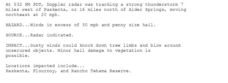
At 532 PM PDT, Doppler radar was tracking a strong thunderstorm 7
miles west of Paskenta, or 16 miles north of Alder Springs, moving
northeast at 20 mph.
HAZARD...Winds in excess of 30 mph and penny size hail.
SOURCE...Radar indicated.
IMPACT...Gusty winds could knock down tree limbs and blow around
unsecured objects. Minor hail damage to vegetation is
possible.
Locations impacted include...
Paskenta, Flournoy, and Rancho Tehama Reserve.
Special Weather Statement issued August 1 at 5:32PM PDT by NWS Sacramento CA
Additional Details Here.
02.08.2025 00:45 — 👍 0 🔁 0 💬 0 📌 0
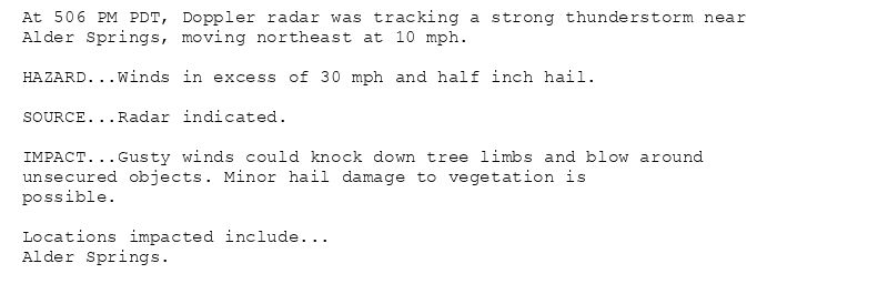
At 506 PM PDT, Doppler radar was tracking a strong thunderstorm near
Alder Springs, moving northeast at 10 mph.
HAZARD...Winds in excess of 30 mph and half inch hail.
SOURCE...Radar indicated.
IMPACT...Gusty winds could knock down tree limbs and blow around
unsecured objects. Minor hail damage to vegetation is
possible.
Locations impacted include...
Alder Springs.
Special Weather Statement issued August 1 at 5:07PM PDT by NWS Sacramento CA
Additional Details Here.
02.08.2025 00:15 — 👍 0 🔁 0 💬 0 📌 0
STO issues A STRONG THUNDERSTORM WILL IMPACT NORTHWESTERN GLENN COUNTY THROUGH 545 PM PDT [wind: 30 MPH, hail: 0.50 IN] for Mountains Southwestern Shasta County to Western Colusa ... at Sat, 02 Aug 2025 00:07:07 +0000 via IEMbot
Additional Details Here.
02.08.2025 00:09 — 👍 0 🔁 0 💬 0 📌 0
STO issues A STRONG THUNDERSTORM WILL IMPACT SOUTHWESTERN TEHAMA COUNTY THROUGH 530 PM PDT [wind: 30 MPH, hail: 0.75 IN] for Mountains Southwestern Shasta County to Western Colusa... at Fri, 01 Aug 2025 23:43:52 +0000 via IEMbot
Additional Details Here.
01.08.2025 23:48 — 👍 1 🔁 0 💬 0 📌 0
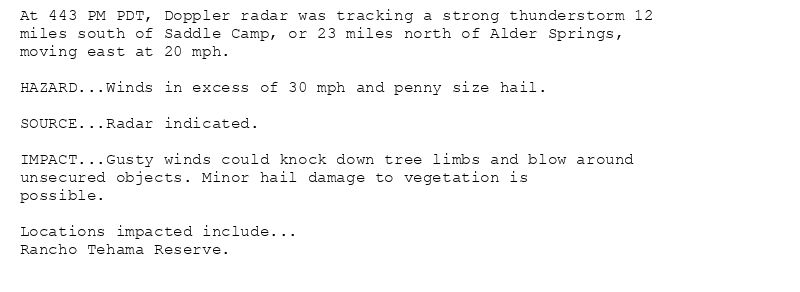
At 443 PM PDT, Doppler radar was tracking a strong thunderstorm 12
miles south of Saddle Camp, or 23 miles north of Alder Springs,
moving east at 20 mph.
HAZARD...Winds in excess of 30 mph and penny size hail.
SOURCE...Radar indicated.
IMPACT...Gusty winds could knock down tree limbs and blow around
unsecured objects. Minor hail damage to vegetation is
possible.
Locations impacted include...
Rancho Tehama Reserve.
Special Weather Statement issued August 1 at 4:43PM PDT by NWS Sacramento CA
Additional Details Here.
01.08.2025 23:45 — 👍 0 🔁 0 💬 0 📌 0
STO issues Area Forecast Discussion (AFD) at Aug 1, 12:34 PM PDT
at Fri, 01 Aug 2025 19:34:39 +0000 via IEMbot
Additional Details Here.
01.08.2025 19:48 — 👍 0 🔁 0 💬 0 📌 0
The Storm Prediction Center issues Day 2 Isolated Dry Thunderstorm Fire Weather Risk at Aug 1, 19:24z for portions of STO
at Fri, 01 Aug 2025 19:24:51 +0000 via IEMbot
Additional Details Here.
01.08.2025 19:28 — 👍 0 🔁 0 💬 0 📌 0
The Storm Prediction Center issues Day 1 Isolated Dry Thunderstorm Fire Weather Risk at Aug 1, 16:43z for portions of STO
at Fri, 01 Aug 2025 16:44:41 +0000 via IEMbot
Additional Details Here.
01.08.2025 16:48 — 👍 0 🔁 0 💬 0 📌 0
MODESTO CA Jul 31
Climate Report:
High: 95
Low: 60
Precip: 0.0"
Snow: Missing
at Fri, 01 Aug 2025 08:53:02 +0000 via IEMbot
Additional Details Here.
01.08.2025 09:08 — 👍 0 🔁 0 💬 0 📌 0