BOU issues Public Information Statement (PNS) at Aug 8, 2:59 AM MDT ...Today in metro Denver weather history... via IEMbot
Additional Details Here.
08.08.2025 09:07 — 👍 0 🔁 0 💬 0 📌 0
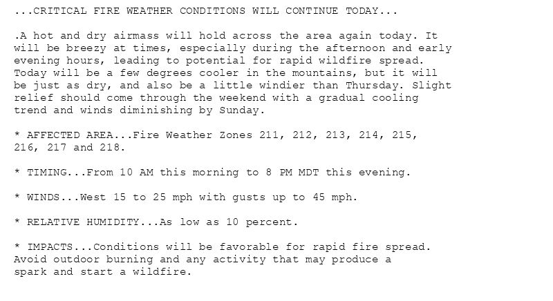
...CRITICAL FIRE WEATHER CONDITIONS WILL CONTINUE TODAY...
.A hot and dry airmass will hold across the area again today. It
will be breezy at times, especially during the afternoon and early
evening hours, leading to potential for rapid wildfire spread.
Today will be a few degrees cooler in the mountains, but it will
be just as dry, and also be a little windier than Thursday. Slight
relief should come through the weekend with a gradual cooling
trend and winds diminishing by Sunday.
* AFFECTED AREA...Fire Weather Zones 211, 212, 213, 214, 215,
216, 217 and 218.
* TIMING...From 10 AM this morning to 8 PM MDT this evening.
* WINDS...West 15 to 25 mph with gusts up to 45 mph.
* RELATIVE HUMIDITY...As low as 10 percent.
* IMPACTS...Conditions will be favorable for rapid fire spread.
Avoid outdoor burning and any activity that may produce a
spark and start a wildfire.
🚨 Red Flag Warning issued August 8 at 2:54AM MDT until August 8 at 8:00PM MDT by NWS Denver CO 🚨
Additional Details Here.
08.08.2025 09:00 — 👍 0 🔁 0 💬 0 📌 0
AKRON CO Aug 7
Climate Report:
High: 99
Low: 58
Precip: 0.0"
Snow: Missing
at Fri, 08 Aug 2025 07:55:03 +0000 via IEMbot
Additional Details Here.
08.08.2025 08:28 — 👍 0 🔁 0 💬 0 📌 0
LIMON CO Aug 7
Climate Report:
High: 99
Low: 51
Precip: 0.0"
Snow: Missing
at Fri, 08 Aug 2025 07:55:02 +0000 via IEMbot
Additional Details Here.
08.08.2025 08:07 — 👍 0 🔁 0 💬 0 📌 0
BOU issues Record Event Report (RER) at Aug 8, 1:53 AM MDT ...RECORD HIGH TEMPERATURE SET AT DENVER CO... via IEMbot
Additional Details Here.
08.08.2025 08:07 — 👍 0 🔁 0 💬 0 📌 0
BOU issues Area Forecast Discussion (AFD) at Aug 8, 1:26 AM MDT
at Fri, 08 Aug 2025 07:29:04 +0000 via IEMbot
Additional Details Here.
08.08.2025 07:47 — 👍 0 🔁 0 💬 0 📌 0
The Storm Prediction Center issues Day 1 Isolated Dry Thunderstorm Fire Weather Risk at Aug 8, 6:32z for portions of BOU
at Fri, 08 Aug 2025 06:34:49 +0000 via IEMbot
Additional Details Here.
08.08.2025 06:48 — 👍 0 🔁 0 💬 0 📌 0
The Storm Prediction Center issues Day 1 Marginal Convective Risk at Aug 8, 6:00z for portions of BOU
at Fri, 08 Aug 2025 06:03:42 +0000 via IEMbot
Additional Details Here.
08.08.2025 06:08 — 👍 0 🔁 0 💬 0 📌 0
The Storm Prediction Center issues Day 2 Marginal Convective Risk at Aug 8, 5:25z for portions of BOU
at Fri, 08 Aug 2025 05:30:02 +0000 via IEMbot
Additional Details Here.
08.08.2025 05:48 — 👍 0 🔁 0 💬 0 📌 0
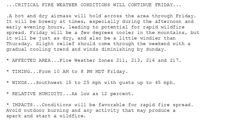
...CRITICAL FIRE WEATHER CONDITIONS WILL CONTINUE FRIDAY...
.A hot and dry airmass will hold across the area through Friday.
It will be breezy at times, especially during the afternoon and
early evening hours, leading to potential for rapid wildfire
spread. Friday will be a few degrees cooler in the mountains, but
it will be just as dry, and also be a little windier than
Thursday. Slight relief should come through the weekend with a
gradual cooling trend and winds diminishing by Sunday.
* AFFECTED AREA...Fire Weather Zones 211, 213, 214 and 217.
* TIMING...From 10 AM to 8 PM MDT Friday.
* WINDS...Southwest 15 to 25 mph with gusts up to 45 mph.
* RELATIVE HUMIDITY...As low as 12 percent.
* IMPACTS...Conditions will be favorable for rapid fire spread.
Avoid outdoor burning and any activity that may produce a
spark and start a wildfire.
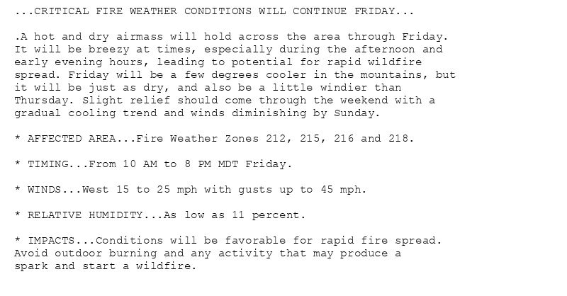
...CRITICAL FIRE WEATHER CONDITIONS WILL CONTINUE FRIDAY...
.A hot and dry airmass will hold across the area through Friday.
It will be breezy at times, especially during the afternoon and
early evening hours, leading to potential for rapid wildfire
spread. Friday will be a few degrees cooler in the mountains, but
it will be just as dry, and also be a little windier than
Thursday. Slight relief should come through the weekend with a
gradual cooling trend and winds diminishing by Sunday.
* AFFECTED AREA...Fire Weather Zones 212, 215, 216 and 218.
* TIMING...From 10 AM to 8 PM MDT Friday.
* WINDS...West 15 to 25 mph with gusts up to 45 mph.
* RELATIVE HUMIDITY...As low as 11 percent.
* IMPACTS...Conditions will be favorable for rapid fire spread.
Avoid outdoor burning and any activity that may produce a
spark and start a wildfire.
🚨 Red Flag Warning issued August 7 at 8:00PM MDT until August 8 at 8:00PM MDT by NWS Denver CO 🚨
Additional Details Here.
08.08.2025 02:15 — 👍 5 🔁 1 💬 0 📌 0
BOU expires Red Flag Warning for Central and Southeast Park County, Grand and Summit Counties Below 9000 Feet, Jackson County Below 9000 Feet, West Jackson and West Grand Counties ... at Fri, 08 Aug 2025 02:00:38 +0000 via IEMbot
Additional Details Here.
08.08.2025 02:08 — 👍 1 🔁 0 💬 0 📌 0
BOU continues Red Flag Warning valid at Aug 8, 10:00 AM MDT for 4 forecast zones in [CO] till Aug 8, 8:00 PM MDT
at Fri, 08 Aug 2025 02:00:39 +0000 via IEMbot
Additional Details Here.
08.08.2025 02:08 — 👍 1 🔁 0 💬 0 📌 0
The Storm Prediction Center issues Day 1 Marginal Convective Risk at Aug 8, 0:59z for portions of BOU
at Fri, 08 Aug 2025 01:01:56 +0000 via IEMbot
Additional Details Here.
08.08.2025 01:08 — 👍 0 🔁 0 💬 0 📌 0
BOU expires Heat Advisory for Boulder And Jefferson Counties Below 6000 Feet/West Broomfield County, Larimer County Below 6000 Feet/Northwest Weld County, North Douglas County Belo... at Fri, 08 Aug 2025 01:07:18 +0000 via IEMbot
Additional Details Here.
08.08.2025 01:08 — 👍 0 🔁 0 💬 0 📌 0
BOU issues Area Forecast Discussion (AFD) at Aug 7, 6:20 PM MDT
at Fri, 08 Aug 2025 00:22:14 +0000 via IEMbot
Additional Details Here.
08.08.2025 00:27 — 👍 0 🔁 0 💬 0 📌 0
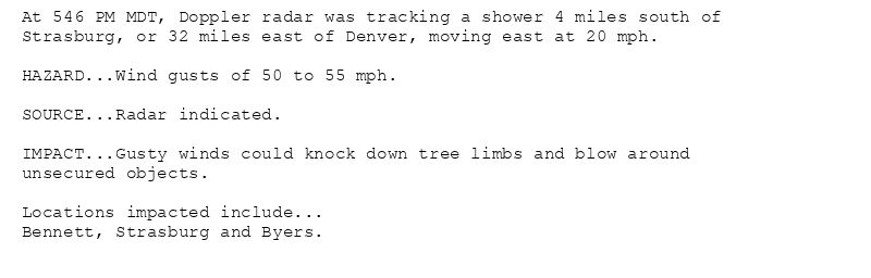
At 546 PM MDT, Doppler radar was tracking a shower 4 miles south of
Strasburg, or 32 miles east of Denver, moving east at 20 mph.
HAZARD...Wind gusts of 50 to 55 mph.
SOURCE...Radar indicated.
IMPACT...Gusty winds could knock down tree limbs and blow around
unsecured objects.
Locations impacted include...
Bennett, Strasburg and Byers.
Special Weather Statement issued August 7 at 5:46PM MDT by NWS Denver CO
Additional Details Here.
08.08.2025 00:00 — 👍 0 🔁 0 💬 0 📌 0
DENVER CO Aug 7
Climate Report:
High: 99
Low: 74
Precip: 0.0"
Snow: Missing
at Thu, 07 Aug 2025 23:30:16 +0000 via IEMbot
Additional Details Here.
07.08.2025 23:48 — 👍 0 🔁 0 💬 0 📌 0
DENVER CO Aug 7
Climate Report:
High: 99
Low: 74
Precip: 0.0"
Snow: Missing
at Thu, 07 Aug 2025 22:31:38 +0000 via IEMbot
Additional Details Here.
07.08.2025 22:48 — 👍 0 🔁 0 💬 0 📌 0
BOU issues Air Quality Alert (AQA) at Aug 7, 4:10 PM MDT ...AIR QUALITY HEALTH ADVISORY FOR WILDFIRE SMOKE FROM 900 AM THURSDAY UNTIL 900 AM FRIDAY... via IEMbot
Additional Details Here.
07.08.2025 22:27 — 👍 0 🔁 0 💬 0 📌 0
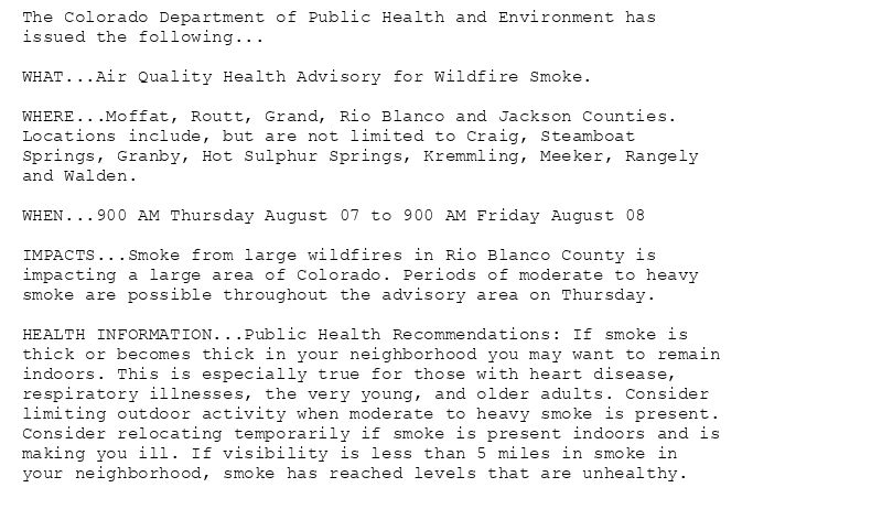
The Colorado Department of Public Health and Environment has
issued the following...
WHAT...Air Quality Health Advisory for Wildfire Smoke.
WHERE...Moffat, Routt, Grand, Rio Blanco and Jackson Counties.
Locations include, but are not limited to Craig, Steamboat
Springs, Granby, Hot Sulphur Springs, Kremmling, Meeker, Rangely
and Walden.
WHEN...900 AM Thursday August 07 to 900 AM Friday August 08
IMPACTS...Smoke from large wildfires in Rio Blanco County is
impacting a large area of Colorado. Periods of moderate to heavy
smoke are possible throughout the advisory area on Thursday.
HEALTH INFORMATION...Public Health Recommendations: If smoke is
thick or becomes thick in your neighborhood you may want to remain
indoors. This is especially true for those with heart disease,
respiratory illnesses, the very young, and older adults. Consider
limiting outdoor activity when moderate to heavy smoke is present.
Consider relocating temporarily if smoke is present indoors and is
making you ill. If visibility is less than 5 miles in smoke in
your neighborhood, smoke has reached levels that are unhealthy.
Air Quality Alert issued August 7 at 4:10PM MDT by NWS Denver CO
Additional Details Here.
07.08.2025 22:15 — 👍 0 🔁 0 💬 0 📌 0
BOU issues Special Weather Statement [wind: 50 MPH, hail: 0.00 IN] for Boulder And Jefferson Counties Below 6000 Feet/West Broomfield County, Central and South Weld County, Elbert... at Thu, 07 Aug 2025 21:34:45 +0000 via IEMbot
Additional Details Here.
07.08.2025 21:48 — 👍 0 🔁 0 💬 0 📌 0
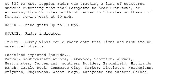
At 334 PM MDT, Doppler radar was tracking a line of scattered
showers extending from near Lafayette to near Franktown, or
extending from 22 miles north of Denver to 29 miles southeast of
Denver, moving east at 15 mph.
HAZARD...Wind gusts up to 50 mph.
SOURCE...Radar indicated.
IMPACT...Gusty winds could knock down tree limbs and blow around
unsecured objects.
Locations impacted include...
Denver, southwestern Aurora, Lakewood, Thornton, Arvada,
Westminster, Centennial, southern Boulder, Broomfield, Highlands
Ranch, Castle Rock, Commerce City, Parker, Littleton, Northglenn,
Brighton, Englewood, Wheat Ridge, Lafayette and eastern Golden.
Special Weather Statement issued August 7 at 3:34PM MDT by NWS Denver CO
Additional Details Here.
07.08.2025 21:45 — 👍 0 🔁 0 💬 0 📌 0
BOU issues Record Event Report (RER) at Aug 7, 3:15 PM MDT ...RECORD HIGH TEMPERATURE TIED AT DENVER CO... via IEMbot
Additional Details Here.
07.08.2025 21:28 — 👍 0 🔁 0 💬 0 📌 0
[Delayed Report] 1 WSW Chatfield Reservo [Jefferson Co, CO] Mesonet reports Non-Tstm Wnd Gst of M59 MPH at 6 Aug, 4:13 PM MDT -- Mesonet station CO007 Littleton C470/Wadsworth.
at... at Thu, 07 Aug 2025 20:10:41 +0000 via IEMbot
Additional Details Here.
07.08.2025 20:27 — 👍 0 🔁 0 💬 0 📌 0
BOU issues Area Forecast Discussion (AFD) at Aug 7, 2:20 PM MDT
at Thu, 07 Aug 2025 20:22:45 +0000 via IEMbot
Additional Details Here.
07.08.2025 20:27 — 👍 0 🔁 0 💬 0 📌 0
The Storm Prediction Center issues Day 3 Marginal Convective Risk at Aug 7, 19:29z for portions of BOU
at Thu, 07 Aug 2025 19:30:34 +0000 via IEMbot
Additional Details Here.
07.08.2025 19:47 — 👍 0 🔁 0 💬 0 📌 0
The Storm Prediction Center issues Day 2 Marginal Convective Risk at Aug 7, 17:30z for portions of BOU
at Thu, 07 Aug 2025 17:32:34 +0000 via IEMbot
Additional Details Here.
07.08.2025 17:48 — 👍 0 🔁 0 💬 0 📌 0
BOU issues Area Forecast Discussion (AFD) at Aug 7, 11:07 AM MDT
at Thu, 07 Aug 2025 17:07:52 +0000 via IEMbot
Additional Details Here.
07.08.2025 17:27 — 👍 0 🔁 0 💬 0 📌 0
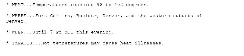
* WHAT...Temperatures reaching 98 to 102 degrees.
* WHERE...Fort Collins, Boulder, Denver, and the western suburbs of
Denver.
* WHEN...Until 7 PM MDT this evening.
* IMPACTS...Hot temperatures may cause heat illnesses.
Heat Advisory issued August 7 at 11:11AM MDT until August 7 at 7:00PM MDT by NWS Denver CO
Additional Details Here.
07.08.2025 17:15 — 👍 0 🔁 0 💬 0 📌 0
The Storm Prediction Center issues Day 1 Isolated Dry Thunderstorm Fire Weather Risk at Aug 7, 16:38z for portions of BOU
at Thu, 07 Aug 2025 16:40:40 +0000 via IEMbot
Additional Details Here.
07.08.2025 16:48 — 👍 0 🔁 0 💬 0 📌 0