Weather community try not to be upset about something 🥺 impossible 💯💯💯
25.11.2025 10:54 — 👍 2 🔁 0 💬 0 📌 0

IEMBot Image TBD
LIX issues Tornado Warning [tornado: RADAR INDICATED, hail: <.75 IN] for St. Tammany [LA] till 5:15 AM CST Link
25.11.2025 10:23 — 👍 0 🔁 1 💬 0 📌 0

What the fuck is weather next gen doing
25.11.2025 09:53 — 👍 1 🔁 0 💬 0 📌 0

Key Messages for Thanksgiving Week Winter Storm
Heavy snowfall to impact Northern Plains to Great Lakes Tuesday and Wednesday
Winter Storm Enters the Northern U.S.
Winter system will enter into the Northern Plains by Tuesday morning, moving east across the Upper Midwest through Wednesday leading to periods of heavy snowfall. Heavy lake effect snow will impact the snow belt downwind of Lake Superior on Wednesday as the main storm moves to the northeast. Lake effect snow will continue into Thanksgiving morning.
Timing and Location of Snowfall
Snowfall will begin Tuesday morning across North Dakota, spreading east into central and northern Minnesota by Tuesday night. Heaviest snow will occur Tuesday night into Wednesday across the Minnesota Arrowhead, northern Wisconsin into the western portions of the Upper Peninsula of Michigan.
Impacts from Heavy Snowfall
Snowfall totals of 4 to 8 inches with locally up to 12 inches are forecast across portions of North Dakota through Minnesota. 1 to 3 feet is forecast downwind of Lake Superior. Heavy snow and gusty winds will help to reduce visibility and allow for icy roads creating hazardous driving conditions.
A winter storm to impact the Northern Plains, Upper Midwest, and Great Lakes this Thanksgiving week. Periods of heavy snow and gusty winds may make travel difficult at times. Be sure to check weather.gov for more information. ❄️
24.11.2025 20:24 — 👍 89 🔁 22 💬 1 📌 6
Could be low end ef2 just based on how populated that area is
25.11.2025 01:53 — 👍 2 🔁 0 💬 0 📌 1
Tor warning! Get to the lowest floor room with no exterior walls, preferably a closet or basement if Ur in this
25.11.2025 01:51 — 👍 0 🔁 0 💬 0 📌 0

Isolated severe thunderstorms are likely across parts of the Southeast/Deep South Tuesday morning into early evening. In the north-central U.S., a storm will bring heavy snow and gusty to high winds over parts of the northern Plains and Upper Midwest Tuesday before impacting the Great Lakes.
25.11.2025 01:49 — 👍 81 🔁 13 💬 2 📌 3
another cyclone hits australia.
22.11.2025 12:24 — 👍 1 🔁 1 💬 0 📌 0

#Fina is now forecast to reach CAT4 #Cyclone intensity, as it impacts #Darwin and surrounds, in #NT and later might impact #WA.
22.11.2025 12:59 — 👍 1 🔁 0 💬 0 📌 0

Cat4 is possible for a brief period. I have updated my forecast track, though this is pretty rough. DO NOT USE FOR LIFE SAVING INFO, INSTEAD VISIT www.bom.gov.au/warning/trop...
FOR OFFICIAL INFO
UPDATED STORMY FORECAST FOR #FINA:
🟦 TROPICAL STORM
🟩 CAT 1
🟨 CAT 2
🟧 CAT 3
🟥 CAT 4
(Aus scale)
22.11.2025 01:51 — 👍 2 🔁 0 💬 0 📌 0

#CYCLONE #FINA is about to make landfall on #Darwin as a cat 3. i could see cat 4 happening if it intensifies just a little bit. take all required preperations, this is a big un'. #weather #australia #tropics
22.11.2025 01:29 — 👍 2 🔁 0 💬 0 📌 0

#Cyclone #Fina Is forecast to impact #Darwin and surrounds at Cat3. Expect heavy impacts. Think tracy, that was of similar intensity. An eye should form pretty soon. Expect some bad flooding, gale force winds and possible loss of power. #weather #australia #forecast #wx #storm
20.11.2025 01:21 — 👍 2 🔁 0 💬 0 📌 0
simply put, it broken :(
19.11.2025 10:49 — 👍 2 🔁 0 💬 1 📌 0

the gfs model is showing a tropical cyclone that uhhh. one on the right would be a normal sized storm. i sure hope its wrong :3
19.11.2025 02:52 — 👍 2 🔁 0 💬 1 📌 0

Isolated strong to severe storms, including a few supercells are possible late this afternoon into this evening. Should stronger storms develop and maintain, hail, and perhaps a tornado or two are possible.
18.11.2025 22:25 — 👍 67 🔁 11 💬 2 📌 2
Intrestingly, the latest model runs and forecasts have it Reintensifying to a Cat two after making landfall. #Weather #Cyclone
18.11.2025 14:48 — 👍 2 🔁 0 💬 0 📌 0

We have our first #Cyclone of the 2025-26 Australian cyclone season. #FINA has formed into a Cat1, and is expected to become a category 2 shortly. Fina is odd in how early it has formed, but its looking spicy.
www.bom.gov.au/weather-and-...
18.11.2025 14:46 — 👍 4 🔁 0 💬 0 📌 1
uh, *boop*
18.11.2025 14:43 — 👍 1 🔁 0 💬 0 📌 0
if you like the weather stuff u can follow me here :3
18.11.2025 12:56 — 👍 2 🔁 0 💬 1 📌 0
HI! this account is WEATHER ONLY. for more silly stuff, and furry stuff, go to @stormysoundfurry.bsky.social :3
please rely on official sources for information first and foremost.
18.11.2025 08:24 — 👍 4 🔁 0 💬 1 📌 0
Furry, shitposter and occasional person who thinks.
https://stormysound.carrd.co
A bit too into meterology :3
WEATHER CONTENT AT @stormysoundwx
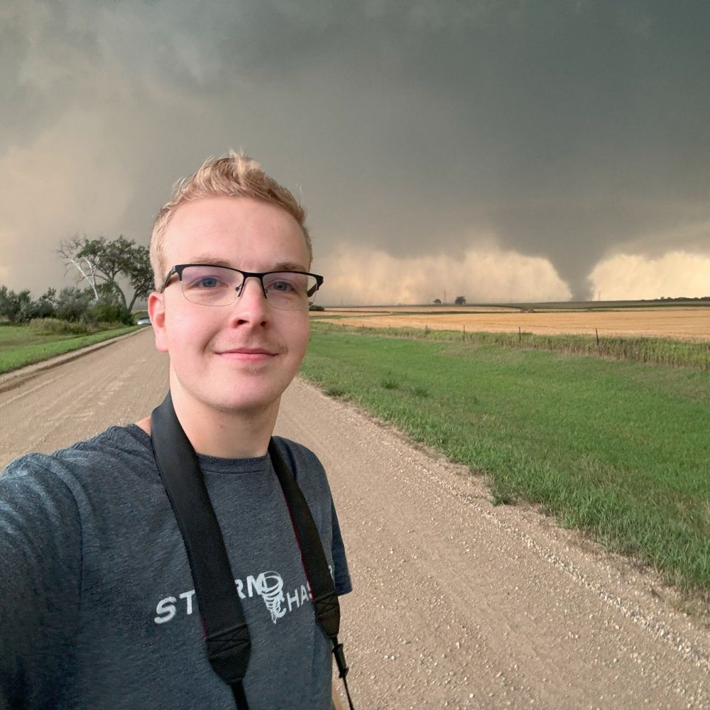
Storm chaser, Aurora hunter, Photographer. Severe storm researcher and M.S. student at UND. SounderPy developer.
MI -> ND
Independent Network covering Weather, Space, & Aviation! TIV 2 Tornado Intercept Vehicle! Random memes! LiveStormChasers.com
Follow along, live & first hand, on exciting storm chases in high definition, for free. Businesses: Use website to contact.
📸 Photographer
🌪️ Storm chaser
🌌 Aurora hunter
📍 South Dakotan
🪪 Licensing options through SevereStudios
🎞️ Check out my work: alexreselwx.com
National News Director at Severe Weather Australia & News Media Network - Storm Spotter & Storm Chaser www.severestorms.com.au
AMS Certified Meteorologist.
Official Bluesky account for NOAA's National Weather Service.
Syndication of NWS Tornado Warnings by IEMBot. @akrherz.bsky.social is my father.
official Bluesky account (check username👆)
Bugs, feature requests, feedback: support@bsky.app