The four longest land borders on Earth.
🔎 Amazing Maps

@civixplorer.bsky.social
𝐓𝐡𝐞 𝐞𝐲𝐞 𝐨𝐟 𝐭𝐡𝐞 𝐰𝐨𝐫𝐥𝐝. 🔎 Keep exploring → www.taplink.cc/civixplorer 🗺️ Get your 3D relief map (𝟭𝟬% 𝗼𝗳𝗳) → www.3dmap.cc/coupon_civixplorer
The four longest land borders on Earth.
🔎 Amazing Maps
The four longest land borders on Earth.
🔎 Amazing Maps

The oldest flags used continuously as the national banner.
13.10.2025 16:46 — 👍 1 🔁 0 💬 0 📌 0
“Map of the Races of Europe”, by National Geographic Magazine (1919)
13.10.2025 14:25 — 👍 3 🔁 1 💬 0 📌 0
⬇️
13.10.2025 12:08 — 👍 2 🔁 0 💬 0 📌 0
💚❤️💛 Green, red and yellow flags, a color scheme deeply rooted in the Pan-African movement — which is your favorite?
13.10.2025 12:08 — 👍 2 🔁 0 💬 1 📌 0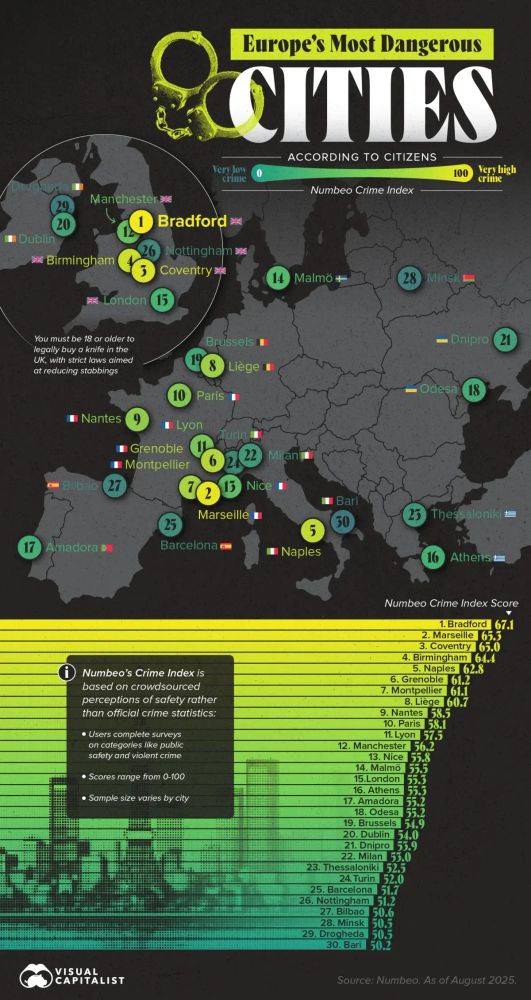
⚠️ The most dangerous cities in Europe according to citizens.
🔎 Visual Capitalist

This map shows the vast extent of Alexander the Great's empire at the time of his death in 323 BC. Spanning over 2 million square miles, the empire stretched from Greece through Anatolia, the Levant, Egypt, Persia, and Central Asia, reaching as far as the Indus River in India. Achieved in just over a decade, it is one of history's largest contiguous empires. Alexander's military genius, combined with his efforts to blend Greek and Eastern cultures, laid the foundation for the Hellenistic era, influencing regions from Egypt to India. However, his empire fragmented after his death, revealing the challenges of sustaining such an immense and diverse territory.
Empire of Alexander the Great.
13.10.2025 06:12 — 👍 1 🔁 0 💬 0 📌 0
💰 Just five countries are responsible for half of Africa’s economy.
13.10.2025 03:22 — 👍 1 🔁 0 💬 0 📌 0
This 1974 map shows Vietnam's division after the Paris Peace Accords, with North Vietnam under communist control and South Vietnam reliant on U.S. support but weakened by corruption and internal struggles. Despite U.S. aid, South Vietnam's leadership faltered, while North Vietnam, led by Le Duan, escalated military efforts for reunification. The map also highlights the broader Cold War context, with communist nations backing the North and the U.S. supporting the South, as conflicts in neighboring Cambodia and Laos intensified. It foreshadows the collapse of South Vietnam in the coming years.
The Vietnam War by 1974.
13.10.2025 00:12 — 👍 4 🔁 1 💬 0 📌 0
What is the best city flag in the United States?
12.10.2025 21:08 — 👍 1 🔁 0 💬 1 📌 0
This WWI Allied propaganda map (1916) imagines a U.S. conquered by the victorious Central Powers.
12.10.2025 18:07 — 👍 3 🔁 0 💬 0 📌 0
Despite 🇻🇪 Venezuela's massive reserves, located in the challenging Orinoco Belt, the country has difficulties extracting its extra-heavy crude oil, investment is insufficient, and there is political instability, preventing it from capitalizing on its natural wealth. Meanwhile, countries like 🇸🇦 Saudi Arabia and 🇦🇪 UAE benefit from abundant, light, sweet crude that is easier and cheaper to extract, contributing to their economic stability and geopolitical influence.
🛢️ Countries with the largest proven oil reserves.
Vast oil reserves don’t always lead to prosperity — factors like oil type, infrastructure, and politics matter.

Land cover of Ukraine 🇺🇦
🔎 Milos Popovic

If interested, we sell 3D relief maps!
🛒 3dmap.cc (code 'civixplorer' for 10% off)

💶 Evolution of the Eurozone.
12.10.2025 12:13 — 👍 1 🔁 1 💬 0 📌 0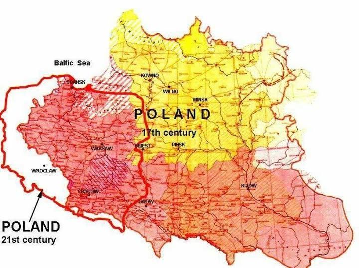
At its 17th-century zenith (around 1619–1620), the Polish–Lithuanian Commonwealth stretched from the Baltic coast (including today’s Lithuania and Latvia) south to the Black Sea shores and east into what is now Belarus, Ukraine and parts of western Russia. In contrast, modern Poland is a more compact state between Germany and Ukraine/Belarus, having lost those vast eastern lands after World War II but gained former German territories to the west.
🇵🇱 Poland at its greatest extent compared to its current borders.
12.10.2025 09:08 — 👍 1 🔁 0 💬 0 📌 0
✍️ Know your cyrillic alphabet — other than Russian.
12.10.2025 06:11 — 👍 3 🔁 0 💬 0 📌 0
The topography of East and Southeast Asia.
12.10.2025 03:18 — 👍 3 🔁 0 💬 1 📌 0
The largest ethnic groups in East Asia.
12.10.2025 00:07 — 👍 3 🔁 0 💬 1 📌 0
It highlights high-value areas, such as major urban centers in the Northeast, California, and the Midwest's fertile agricultural zones, where land prices can exceed $500,000 per hectare. In contrast, remote and arid regions in the Southwest and Western plateaus show significantly lower values, often under $5,000 per hectare. The map illustrates how factors like population density, economic activity, and local policies shape land values, while public lands and Native American reservations are excluded from the private market valuation.
🏘️ The most and least expensive land in the contiguous United States.
11.10.2025 21:08 — 👍 1 🔁 1 💬 0 📌 0
Standard paper sizes in the world.
🟡 A4
🔵 US Letter
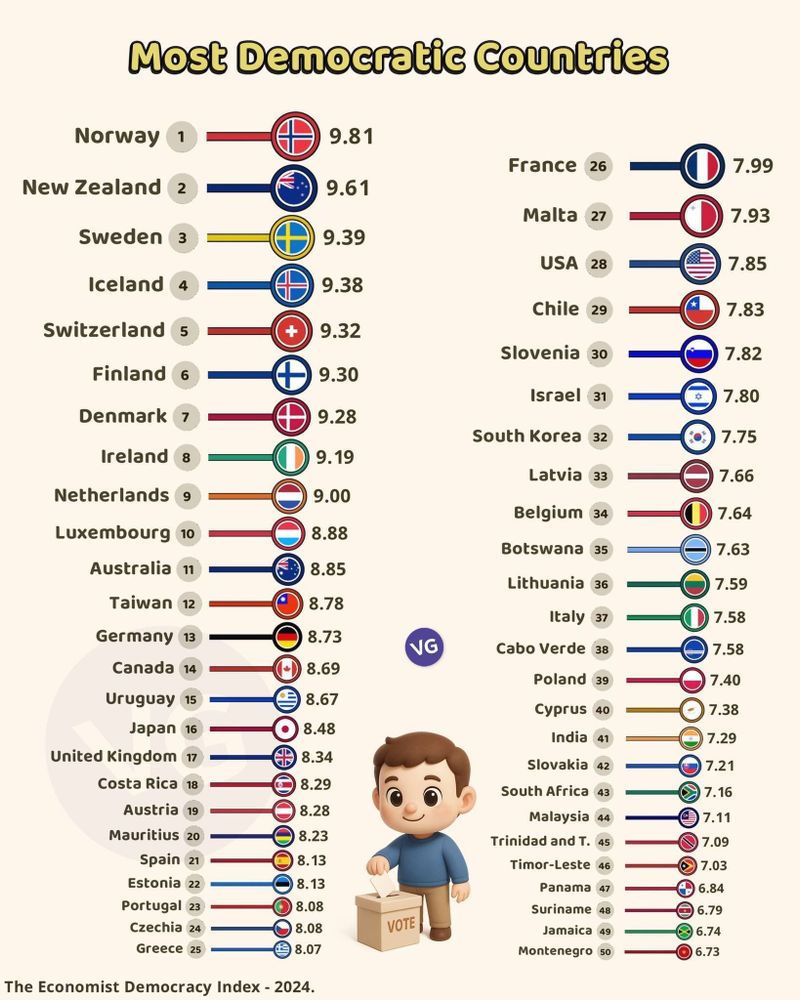
⚖️ The most democratic countries, according to The Economist.
11.10.2025 16:07 — 👍 6 🔁 1 💬 0 📌 1
🎗️ The most commonly diagnosed types of cancer.
🔎 Arciom Antanovič

🚗 Comparing the changing landscape of global car sales.
11.10.2025 12:08 — 👍 6 🔁 2 💬 0 📌 5
Coined in 1989 by geographer Roger Brunet, it highlights Europe's primary hub of industry, finance, and innovation, centered on cities like London, Frankfurt, and Milan. The Blue Banana represents a historical network of trade, industry, and post-WWII integration, though recent shifts in industrial power to Eastern Europe reflect broader economic changes.
🍌 The Blue Banana: Europe’s most densely populated corridor with around 111 million people.
11.10.2025 09:08 — 👍 5 🔁 2 💬 0 📌 0
🇧🇪 Belgium, a linguistically divided country.
🔎 geo.universe

The farthest point on Earth from any ocean.
📍 Xinjiang, China 🇨🇳

The shortest driving route through all 48 contiguous U.S. states.
It takes 113 hours, almost 5 days.

The 144 most populous counties in the United States account for half of the country’s population.
10.10.2025 21:07 — 👍 5 🔁 0 💬 0 📌 1