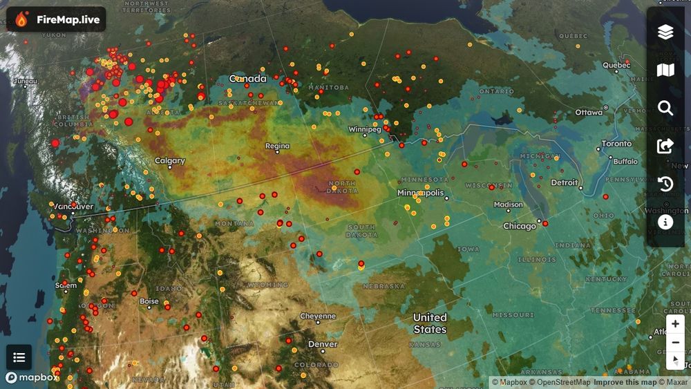
Satellite imagery showing dense wildfire smoke covering southern Canada, particularly heavy over Saskatchewan and Manitoba, extending down into North Dakota. Lighter smoke is visible stretching eastward, reaching cities like Calgary, Edmonton, Toronto, and Chicago. Data from FireMap’s hourly smoke monitoring.
🌬️ Smoke Alert: Ever wonder how wildfire smoke travels so far? Right now, smoke from Alberta & BC wildfires stretches across the Prairies, affecting Calgary & Edmonton, and reaching as far as Chicago & Toronto. Hourly monitoring available now on FireMap
11.06.2025 16:44 — 👍 3 🔁 0 💬 0 📌 0
Lots of interesting maps and data in there. Thank you!
09.06.2025 18:43 — 👍 2 🔁 0 💬 0 📌 0
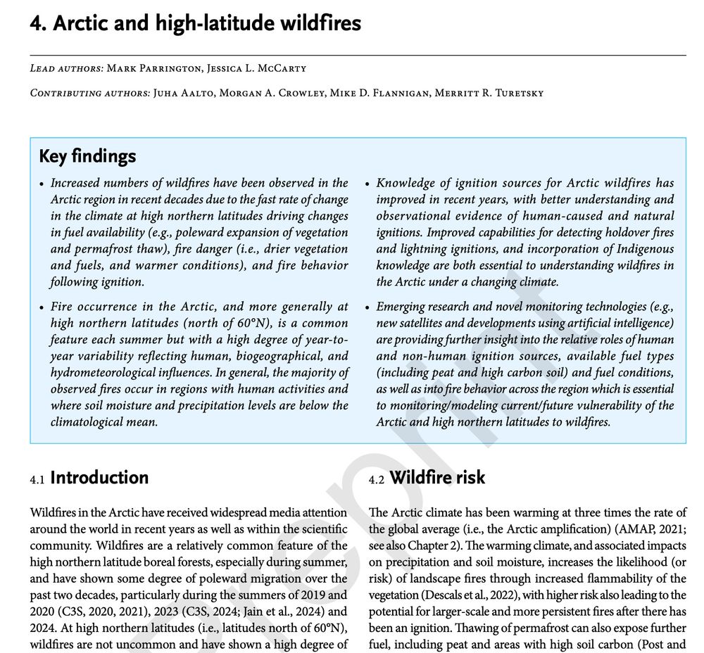
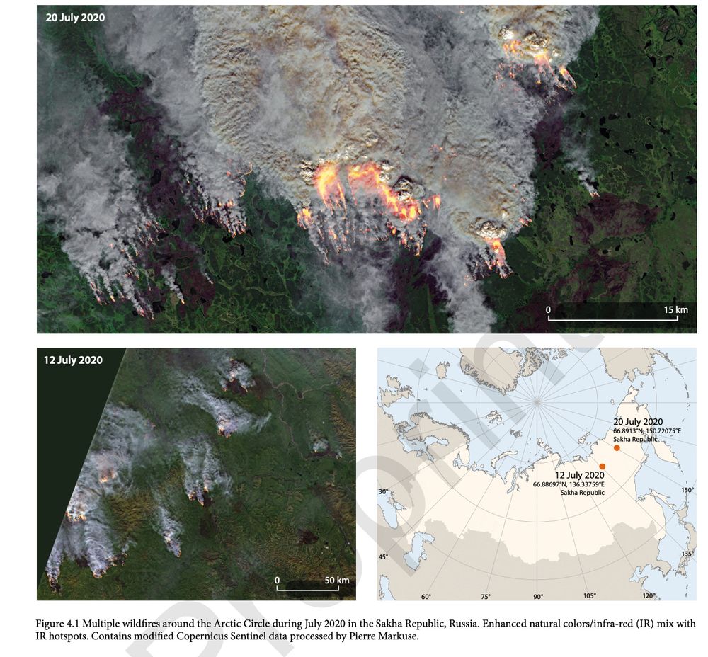
First look at preprint of the AMAP Arctic Climate Change Update 2024 report www.amap.no/documents/do... and Chapter 4 on #Arctic & high-latitude #wildfires with thanks to co-authors @jmccartygeo.bsky.social Juha Aalto @morganahcrowley.bsky.social @queenofpeat.bsky.social & @mikeflannigan.bsky.social
09.06.2025 18:24 — 👍 45 🔁 15 💬 3 📌 1
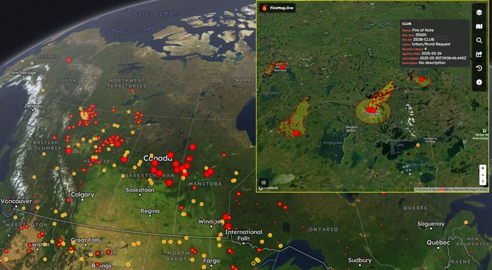
🌲🔥 Wildfires blazing across provincial boundaries in Canada's Prairies—FireMap.live delivers real-time clarity.
Wildfires continue to significantly impact communities across Canada, particularly in Manitoba, Alberta, and Saskatchewan. FireMap provides real-time satellite data and boundary-free tracking, offering critical insights for emergency responders and affected communities.
📍 Explore now: FireMap.live
30.05.2025 20:35 — 👍 3 🔁 1 💬 0 📌 0
Absolutely—tracking these fires is challenging. We've linked authoritative data with real-time satellite sensors on FireMap.live, letting you quickly pinpoint which fires are most active, boundary-free. Stay informed and safe! 🔥🛰️🌎
30.05.2025 20:40 — 👍 4 🔁 1 💬 0 📌 0
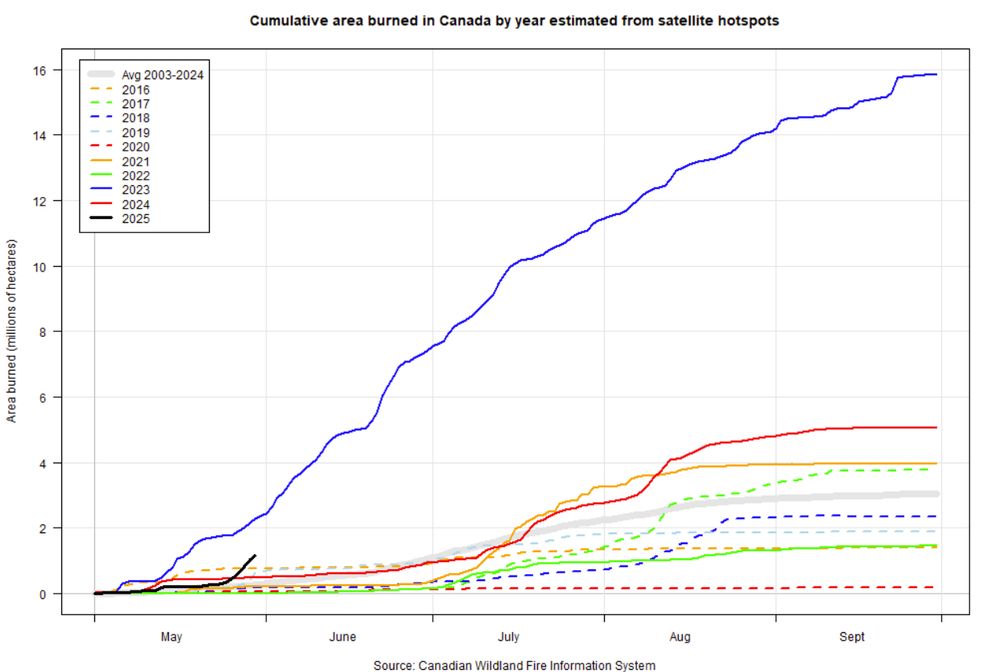
Graph showing area burned in Canada by day of the year
Area burned over 1 million hectares in Canada and increasing. Second only to the 2023 in terms of area burned for this time of year. @ciffc.bsky.social
ciffc.ca
cwfis.cfs.nrcan.gc.ca/maps/fm3?typ...
30.05.2025 20:01 — 👍 115 🔁 79 💬 3 📌 4
🌲🔥 Wildfires blazing across provincial boundaries in Canada's Prairies—FireMap.live delivers real-time clarity.
Wildfires continue to significantly impact communities across Canada, particularly in Manitoba, Alberta, and Saskatchewan. FireMap provides real-time satellite data and boundary-free tracking, offering critical insights for emergency responders and affected communities.
📍 Explore now: FireMap.live
30.05.2025 20:35 — 👍 3 🔁 1 💬 0 📌 0
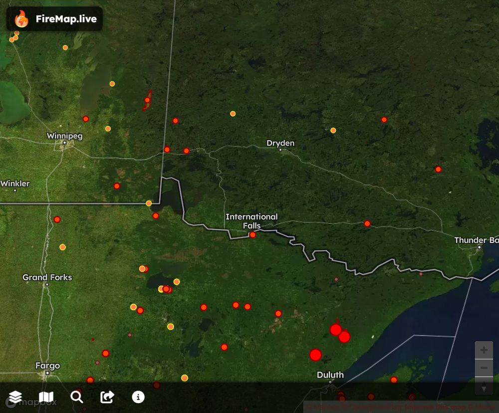
Feel fire to check FireMap for satellite hotspots and burned area boundary updates.
firemap.live?lng=-93.4505...
13.05.2025 22:25 — 👍 3 🔁 0 💬 0 📌 0
When your friend catches a lava fountain on his birthday… shout out to Scott Malis for this insane Kīlauea footage. Volcano gods delivered 🔥🌋
03.04.2025 01:35 — 👍 1 🔁 0 💬 0 📌 0
bsky.app/profile/fire...
28.03.2025 20:37 — 👍 0 🔁 0 💬 0 📌 0
Table Rock, Persimmon Ridge, Big Ridge—& countless others. Wildfires are raging across the Carolinas & Georgia NOW. FireMap.live gives you live satellite hotspots & epic 3D views. We’ve got every blaze here—and worldwide—covered. Watch, share, stay alert—see FireMap
28.03.2025 20:36 — 👍 0 🔁 0 💬 0 📌 1
When it comes to mapping it does seem that BC is more liberal with classifying fires as active than other jurisdictions. I wonder if there is still a heat signature coming off these ones in NE BC?
24.02.2025 20:19 — 👍 0 🔁 0 💬 0 📌 0
A wildfire burning in Alpine National Park, west of Avon Wilderness Area and east of Licola, 200 miles northeast of Melbourne, Australia has reached 3,000+ acres. See the initial 3D boundaries on FireMap. Satellites detected 184 hotspots in the last 24 hours.
24.02.2025 19:45 — 👍 4 🔁 2 💬 0 📌 0
Wildfires in Northwestern Tasmania Australia🔥
Dry lightning has sparked multiple large fires in northwestern Tasmania, including the 8,000-hectare Yellowband Plain Fire and another near Canning Peak, closing the Overland Track. See FireMap.live for 3D burned area boundaries and real-time updates
11.02.2025 23:29 — 👍 0 🔁 0 💬 0 📌 0
A new wildfire, the Laguna Fire, broke out this morning in Ventura County, California.
Officials have called for evacuations, and Cal State University Channel Islands is under an evacuation order.
Hopefully they put it out quickly!
23.01.2025 18:01 — 👍 194 🔁 37 💬 15 📌 3
Here is an overview of the burned area boundary for Laguna Fire
bsky.app/profile/fire...
23.01.2025 18:46 — 👍 1 🔁 0 💬 0 📌 0
Scary how little coverage this is getting.
23.01.2025 18:45 — 👍 1 🔁 0 💬 0 📌 0
Initial burn area boundary mapped for #LagunaFire near California State University Channel Islands campus in Ventura County. See #FireMap for updates
23.01.2025 18:42 — 👍 1 🔁 0 💬 0 📌 1
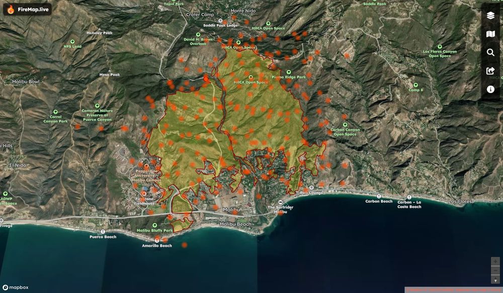
See 3D Franklin Fire Boundaries & Hotspots Mapped
-Malibu’s Franklin Fire Explodes: Residents Flee, Pepperdine Shelters in Place
#FranklinFire #MalibuFire #FireMap
10.12.2024 18:43 — 👍 3 🔁 2 💬 0 📌 0
De novo genomic sequencing of Phlebotaenia cowellii 🧬🌳
(Puerto Rican endemic)
“Reality runs deeper than social media.”
Caribbean 🌊 | SP / EN
Between code, roots, and rhythm.
Watching the Climate Collapse 👀
#Photography Born ~318ppm #pnw #climate #quitflying
Professor, scientist, mom. Chaser of wildfires and permafrost thaw. I love bogs and want you to join me.
Forest Fire Research Scientist with Canadian Forest Service 🔥🌲🌳 and the WildFireSat mission 🚀🛰 📡 | Advancing how we use satellites to monitor fires and their impacts | Woman in Remote Sensing | Mother in Science 💻👩💻👩🔬🧪 | she/hers | celiac | 📚🎵🎶👟☕️ | 🇨🇦🇺🇸
🔥🛰️🌱 Science, mainly.
🔵Nicer online than in-person.
⚪️Actual real-life Kentucky hillbilly, currently California resident.
🔴Personal account. I do not speak for my employer, all posts mine alone.
The Canadian Interagency Forest Fire Centre (CIFFC) is a federally incorporated not-for-profit corporation owned and operated by the federal, provincial, and territorial agencies responsible for wildland fire management in Canada.
🇿🇦 Scientist. Interested in soil science , fire ecology🔥, hydrology 💧, nature conservation 🌍. Cellphone Photographer. Lover of pot plants 🪴 and rugby, obviously.
Understanding and supporting people in their spatial interactions through computational #spatial #data #science #giscience #melbourne 🛶🚵♂️🥾🏊♂️🐕
@unimelb, own views. support 🇺🇦 www.tomko.org
I paint the world with #rstats and teach you how to unleash your inner #map artist. Join my map adventures and tutorials now:
https://youtube.com/@milos-makes-maps
fire guy, weather guy, researcher, professor and research chair.
Thompson Rivers University
Scientist/Adventurer. @CRC_CRC Developmental Origins of Health & Disease. @UManitoba @CHRIManitoba @CHILDStudy #THRiVElab #Breastmilk #Microbiome #NatureSelfies
www.thrivediscovery.ca
Wildfire Mitigation | Emergency Management
I help communities coexist with wildfire
Lillooet, BC | Canada
ECMWF senior scientist working on monitoring global #wildfire emissions, #airquality, atmospheric chemistry & #scicomm for the #CopernicusAtmosphere Monitoring Service @copernicusecmwf.bsky.social @ecmwf.int