Even happier that this work appears in one of the journals of the French Academy of Sciences, which should become an increasingly prominent forum for discussing our science in the years to come!
30.01.2026 10:29 —
👍 0
🔁 0
💬 0
📌 0
An outlook on the rapid decline of carbon sequestration and perspectives for an improved monitoring of French forests
Very happy to be part of the team lead by P. Ciais behind a paper conveying an important message: investing BOTH in remote sensing developments and large-scale field-based monitoring protocols is essential to monitor, and hopefully preserve, the forest carbon sink in France.
➡️ lnkd.in/eQz4dhmT
30.01.2026 10:29 —
👍 1
🔁 0
💬 1
📌 0


My PhD student Selim and I are looking for a motivated Master student to take on a pretty cool challenge: testing the NASA GEDI L4B biomass product across mainland France using a version of the algorithm Selim has been developing in his PhD -building on IGN’s LiDAR HD and NFI data.
Pls share! :)
17.10.2025 05:30 —
👍 3
🔁 2
💬 1
📌 0

Multiple models, one forest: a Bayesian perspective.
Led by Nicolas Picard, we combined climate-sensitive forest models to see where they agree - and where they don’t.
A better way to predict European beech’s future in a changing climate.
Read more 👉 authors.elsevier.com/c/1lrB815DJ-...
27.09.2025 13:10 —
👍 11
🔁 2
💬 0
📌 1

L’océan face au changement climatique | Météo-France
En absorbant la chaleur, l'océan a un important effet modérateur sur le climat et ses changements. Il est aussi particulièrement vulnérable au réchauffement climatique global et à l'augmentation du co...
La Journée mondiale de la mer est aujourd'hui.
Pour l'occasion, un article grand public sur l'importance des océans dans le système climatique :
- une augmentation de l'acidité
- des extrêmes chauds + intenses et + chauds
- un niveau qui ↗️
Avec des conséquences désastreuses
👇
tinyurl.com/bdcmx2hb
25.09.2025 08:10 —
👍 12
🔁 5
💬 0
📌 0


Want to do a PhD in remote sensing? Interested in mountain forest ecosystems? Then apply for a PhD position in our lab! You will be part of the newly founded Centre for Forest Management in the Alps, working on scaling tree productivity from tree to landscape scale. Deadline 21st September.
04.09.2025 11:55 —
👍 19
🔁 10
💬 1
📌 0
Many thanks to Martin, Philippe, and all other co-authors for the great collaboration!
4/4
24.08.2025 19:37 —
👍 0
🔁 0
💬 0
📌 0
🔍 More highlights:
- Height time series captures local forest growth, validated with ALS.
- Species-specific height–age curves consistent with field data.
3/4
24.08.2025 19:37 —
👍 2
🔁 0
💬 1
📌 0
🔍 Highlights:
- Yearly forest height, AGB, and GSV maps (2018–2024) at 10–30 m resolution in France.
- Canopy height validated with NFI data (MAE = 3.07 m).
2/4
24.08.2025 19:37 —
👍 0
🔁 0
💬 1
📌 0

Retrieving yearly forest growth from satellite data: A deep learning based approach
High-resolution mapping of forest attributes is crucial for ecosystem monitoring and carbon budget assessments. Recent advancements have leveraged sat…
Happy to be part of the team led by Martin Schwartz (@lsce-ipsl.bsky.social) behind our new publication:
“Retrieving yearly forest growth from satellite data: A deep learning based approach.”
📖 Published in Remote Sensing of Environment:
www.sciencedirect.com/science/arti...
1/4
24.08.2025 19:37 —
👍 13
🔁 5
💬 1
📌 0
🌳 One of my dearest projects—with brilliant friends and colleagues—is out in @NatureComms
We show that how you plant tree species (not just which) can significantly boost forest functioning.
🔗 rdcu.be/evtXs
👇 A short thread
09.07.2025 12:01 —
👍 15
🔁 8
💬 1
📌 0
Interested in working with a fun and inspiring team? We are looking for a new PhD (mountain forest management) and PostDoc (forest adaptive capacity, w/ @juditlecinadiaz.bsky.social)
Comes along with:
🧗🏻♀️ mountain/ sport buddies
🙃 good + bad jokes
☕️👬amazing social time
💭 great ideas and conversations
04.08.2025 10:25 —
👍 7
🔁 1
💬 0
📌 0
Keep sciencing. We are living through a time when looking at a rock and wondering how old it is qualifies as an act of resistance.
02.08.2025 13:45 —
👍 1047
🔁 259
💬 17
📌 16

#Archives2025 👉En France, la baisse des émissions de gaz à effet de serre prévue en 2025 n’est que de 0,8 % selon le baromètre du Citepa. Un chiffre jugé alarmant par le climatologue Jean Jouzel, qui dénonce un « relâchement » général.
➡️ https://go.publicsenat.fr/Gy7
29.07.2025 15:29 —
👍 60
🔁 33
💬 3
📌 5

[Replay] Séminaire de Valérie Masson-Delmotte - LSCE
Valérie Masson-Delmotte présente les principales conclusions du dernier rapport du Haut Conseil pour le Climat : "Relancer l'action climatique face à l'aggravation des impacts et à l'affaiblissement d...
Replay et diapos du séminaire sont disponibles (lien 🎥)
@valmasdel.bsky.social revient sur les principales conclusions du dernier rapport du @hc-climat.bsky.social qui a été présenté puis remis au premier ministre la semaine dernière.
www.lsce.ipsl.fr/replay-semin...
@cea.fr @ipsl.bsky.social
23.07.2025 07:03 —
👍 36
🔁 18
💬 1
📌 4
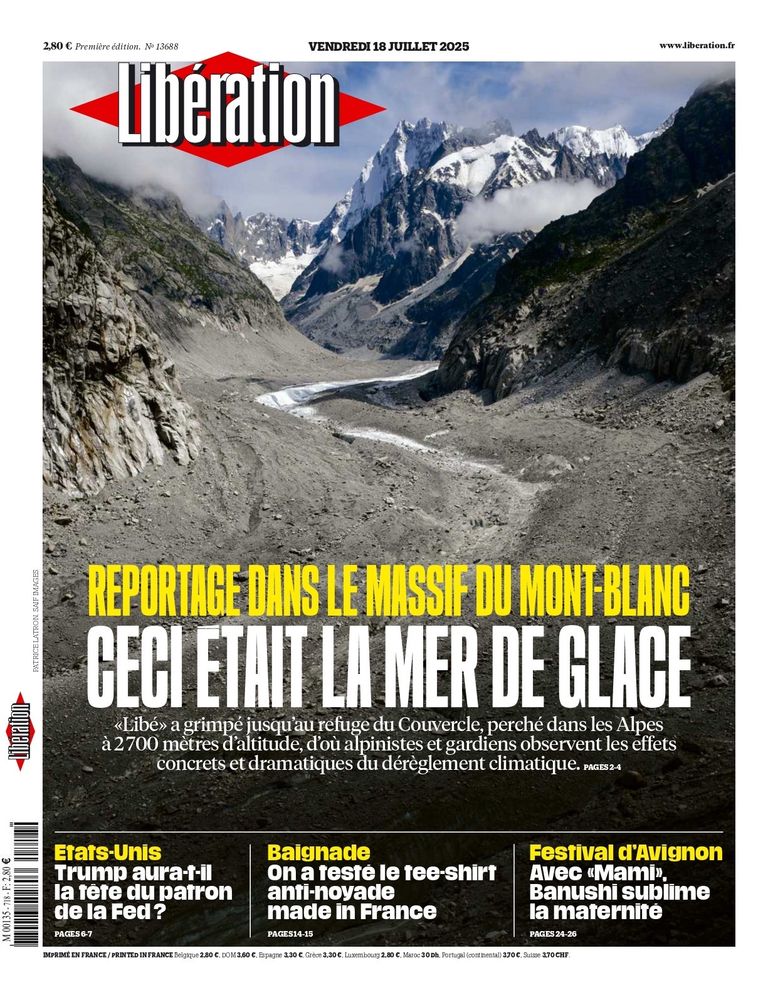
La couv de Libe de demain
Titraille bien triste
17.07.2025 19:50 —
👍 116
🔁 43
💬 5
📌 3
gabdst/TurbulenceFlux.jl: v0.2.0
A Julia package for high resolution flux estimation
🛠️ Try the tool: zenodo.org/records/1531...
Congrats again to @gbrldst.bsky.social for leading this important step toward more accurate and flexible flux measurements!
#EnvironmentalMonitoring #CarbonCycle #EcosystemFluxes #Wavelets
(5/5)
16.07.2025 05:31 —
👍 1
🔁 0
💬 0
📌 0
📍 At the Hesse forest site (FR-Hes @icos-ri.eu), this method reveals:
– higher summer carbon uptake (+2 ± 1 µmol/m²/s)
– better nighttime respiration estimates
– strong agreement with standard EC
Implemented in TurbulenceFlux.jl (Julia)
(4/5)
16.07.2025 05:31 —
👍 1
🔁 0
💬 1
📌 0
@gbrldst.bsky.social introduces a wavelet-based method to analyze turbulent fluxes in time & frequency, using a metric based on the vertical Reynolds stress tensor to adaptively localize turbulence.
This helps separate turbulence from advection.
(3/5)
16.07.2025 05:31 —
👍 0
🔁 0
💬 1
📌 0
🌍 Flux towers are essential for tracking CO₂, water vapor, and heat exchange between ecosystems and the atmosphere.
But traditional 30-min eddy-covariance averaging often misses rapid responses to environmental change.
(2/5)
16.07.2025 05:31 —
👍 0
🔁 0
💬 1
📌 0
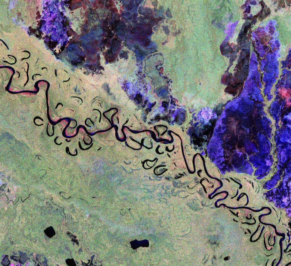
This image features part of Bolivia. This vibrant image was created using the radar instrument’s different polarisation channels, with each colour revealing distinct characteristics of the landscape. For instance, green hues mainly represent rainforest, red hues forested floodplains and wetlands, and blue–purple is indicative of grasslands, while black areas are rivers and lakes. The image spans approximately 90 km along the Biomass satellite's flight path (length) and 60 km across in width, with north oriented to the right.
🆕 The first stunning images from our groundbreaking #Biomass satellite mission have been released – they mark a major leap forward in our ability to understand how Earth’s forests are changing and exactly how they contribute to the global carbon cycle 🌳🌍
www.esa.int/Applications...
23.06.2025 10:55 —
👍 311
🔁 58
💬 4
📌 14
"La France ne s'adaptera pas à un réchauffement climatique de +4°C"
Intervention magistrale de @cassouman40.bsky.social . Chaque phrase prononcée est précise et lourde de sens. Un discours lucide sur le service public qui mériterait d'être entendu de tous les Français.
21.06.2025 07:17 —
👍 1694
🔁 1026
💬 39
📌 56

Schematic diagram showing the major axes of tree crown architecture
So excited to finally share our new paper charting the global spectrum of tree crown architecture, out today at @natcomms.nature.com 🧪🌐
Paper link 🔗: www.nature.com/articles/s41...
A brief thread of what we found 🧵
27.05.2025 10:31 —
👍 145
🔁 63
💬 5
📌 3
🤩💚
01.05.2025 20:01 —
👍 3
🔁 0
💬 0
📌 0
Hi folks! Make sure to have a look at this cool work - it introduces a framework for producing 1.5 m-resolution canopy height maps across metropolitan France, opening the door to numerous exciting applications.
@loicland.bsky.social @ciais-philippe.bsky.social
01.05.2025 07:05 —
👍 3
🔁 0
💬 0
📌 0