Noto coast in Nov. 2023.
Waves come all the way up to a concrete embankment protecting a cliff

Noto Coast after 2 m coseismic uplift.
100 m wide rock platform is now emerged

A road is now built on the bedrock platform, protected by a new sea wall
On Noto Peninsula where coseismic uplift was ~2m.
Sequence pre-earthquake, EQ +3 months, EQ +23 months. I thought we would be able to monitor this nice flat surface for weathering efficiency over the years…
14.11.2025 21:43 —
👍 18
🔁 3
💬 1
📌 0

Landscape changes caused by the 2024 Noto Peninsula earthquake in Japan
Deformation due to the Noto Peninsula earthquake showed that its repetition shaped the Peninsula’s modern landscapes.
Our work on surface deformation by the Noto Earthquake is finally out! Fukushima Yo led a team to create and ground-truth a full 3D deformation field from InSAR on the entire Peninsula. We show that repetition of similar quakes explains the 1st-order landscape features. 1/5
doi.org/10.1126/scia...
05.12.2024 22:38 —
👍 30
🔁 7
💬 2
📌 0
As I mentioned earlier I think Shimosueyoshi is the closest equivalent to Eem in Japan (at least for geomorphologists). And M1 is also commonly used by Ota and other authors for Shimosueyoshi terraces (including earlier work like Yoshikawa et al on Muroto).
03.12.2024 18:51 —
👍 1
🔁 0
💬 0
📌 0
As I mentioned to Luca earlier I think Shimosueyoshi is closest to Eemian equivalent in Japan, at least for geomorphologists. And yes, M1 is also commonly used for Shimosuesoshi terraces, not only by Ota but from earlier studies like Yoshikawa et al 1964 on Muroto.
03.12.2024 18:46 —
👍 3
🔁 0
💬 0
📌 0
I have just checked ‘inventory of quaternary outcrops’ by Japan association of quaternary research. It says that in the topo map of 1982 the outcrop already disappeared…
03.12.2024 12:35 —
👍 3
🔁 0
💬 1
📌 0

A pine tree on a cliff overlooking the coast that extends in the distance. Some km away, a terrace is highlighted by yellow pencil

A vegetated road cut in a flat surface (supposed MIS9 terrace). On the road cut yellow dots highlight the terrace surface. A red dashed line follows the estimated position of the bedrock strath. A pink rectangle outlines a scraped of segment of the road cut surface

Picture of the scraped off surface from the previous image. The upper part is made of soil and scattered cobbles. The lower part is made of pebbles and cobbles in a cemented matrix. Clasts have varying lithologies. They are generally poorly sorted but layers of finer grained material exist.

Same image as previous with pencil annotations highlighting lithologies of clays existing both in bedrock and sediment cover as well as clasts of weak tuff only existing in the bedrock
A recurring question for us: Where do beach cobbles come from?
Here a cool answer on a ~340ka terrace that shows strath & sed cover:
(Salt?) weathering of volcaniclastics frees clasts when it was a coastal (intertidal?) platform. Strongest survive & make up sediment. Or so we think.
14.11.2024 12:05 —
👍 4
🔁 1
💬 0
📌 1

Map of Noto Peninsula and Sado Island, arrows show direction of waves, pink lines represent distribution of terraces, red lines mark main (active) faults. The figure shows that Noto and Sado face the same wave condition but Noto has terraces on its shielded side, while they are on the wave-exposed side of Sado.
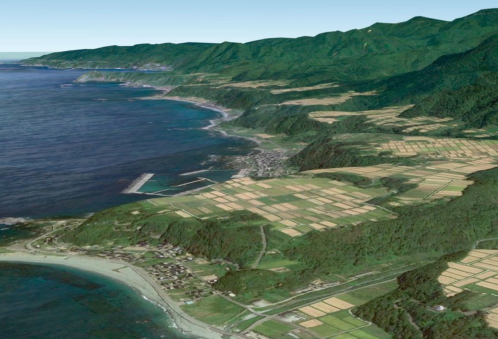
Oblique view from Google Earth of marine terraces covered by rice paddies along the NW coast of Sado Island.
Some context for the 🇯🇵 pictures I am posting. @sumikotsuka.bsky.social & I are working on Sado Island and Noto Peninsula since '23 for the DFG project TEMARI. Both sites face 🌊 on 1 side, are tectonically active (Noto EQ), & have many many marine terraces
*What controls the creation of terraces?
01.11.2024 14:01 —
👍 7
🔁 1
💬 0
📌 0
ちょっと違う😂
28.10.2024 19:00 —
👍 0
🔁 0
💬 0
📌 0
Redirecting
If you have dirty and seemingly ’undatable‘ speleothem samples in your lab - look no further! Isothermal Thermoluminescence (ITL) dating can help you ! Look at our latest study led by Junjie Zhang & Sumiko Tsukamoto of #LIAG and #TuebingenUni : eur02.safelinks.protection.outlook.com?url=https%3A...
29.09.2024 16:17 —
👍 4
🔁 3
💬 0
📌 1

North coast of Noto last November, the water reaches the cliff.

North coast of Noto after the earthquake, the water is 50-100 m away from the cliff.

North coast of Noto last November, the water reaches the cliff.

North coast of Noto after the earthquake, the water is 50-100 m away from the cliff.
We were able to reach the same spot on the north coast of Noto Peninsula where I took pictures last November. That was before the earthquake and the ~1.7m of uplift it caused at this location.
Before/after below
04.03.2024 08:47 —
👍 18
🔁 5
💬 0
📌 0

As a result of liquefaction, we see manholes shooting up across the pavement. At first I thought it was the land sinking around fixed water pipes, but it seems that they do actually move up. Is it a matter of buoyancy? They're mostly empty after all. Does someone here know?
03.03.2024 12:02 —
👍 1
🔁 2
💬 1
📌 0

A steep coast with a large swath of white rocks that separate a settlement and harbor from the coastline a couple hundred metres further.
Back in Noto Peninsula 🇯🇵 for a post earthquake survey. Here you see a bay near Monzenmachi, we measured 4.4m of coseismic uplift. The white rocks are covered by organisms that lived in the sea, now perennially emerged. Note the now dry harbor on the right.
02.03.2024 13:13 —
👍 35
🔁 9
💬 0
📌 0