Arrived in Christchurch, and in summer, for the IAG conference. Good vibes all around.
01.02.2026 06:52 — 👍 2 🔁 0 💬 0 📌 0
Nice Keynote to start day 2 of #ISC2026 from Prof Kyoto Kataoka using sediment cores from lakes and basins to study the volcanic activity from Japanese volcanoes. Looking at tephra, lahar and a range of volcanic erupt I’ve outputs - shows a much more complex and comprehensive volcanic history.
27.01.2026 04:26 — 👍 4 🔁 1 💬 0 📌 0

An airplane panoramic view of Mt Fuji and surrounding. The summit is coated in white snow.
Fuji san upon arrival last Friday.
65x24
🗻
26.01.2026 11:24 — 👍 4 🔁 0 💬 0 📌 0

A de icing machine sprays the wing of an aircraft
Trichromatic de-icing
with Trichromy from @heliographe.studio
23.01.2026 06:00 — 👍 2 🔁 0 💬 1 📌 0

Mass start at the Neues Palais in Potsdam
22.01.2026 07:46 — 👍 4 🔁 0 💬 0 📌 0

A new preprint, led by Bar Oryan, introduces the Coupling Cloud: a community database that curates, standardizes, documents, and disseminates published kinematic coupling models inverted from geodetic data. As of today it brings together 96 coupling datasets drawn from 55 publications spanning
19.01.2026 05:26 — 👍 6 🔁 4 💬 1 📌 0

The regular expression to split text into tokens before identifying and grouping changes. By Frederik Tilmann.
Frederik Tilmann has published an interesting post about the development of `latexdiff` since 2004 as version 1.4.0 is just released. Besides `latexdiff` Frederik also busies himself with being a professor of seismology.
www.linkedin.com/pulse/some-r...
12.01.2026 10:50 — 👍 2 🔁 1 💬 0 📌 0
These cumulative energy release plots are always great visuals
05.01.2026 16:25 — 👍 4 🔁 0 💬 0 📌 0
Fog streams.
Mont Blanc in the top left.
27.12.2025 17:06 — 👍 6 🔁 1 💬 0 📌 0

Mt Blanc in late afternoon light from the Jura
27.12.2025 20:26 — 👍 7 🔁 0 💬 0 📌 0
Fog streams.
Mont Blanc in the top left.
27.12.2025 17:06 — 👍 6 🔁 1 💬 0 📌 0
Beautiful. Missing it. everything remains so crisp in the distance.
25.12.2025 23:08 — 👍 0 🔁 0 💬 0 📌 0
Ho ho ho, Daisuke Ishimura @daisukeishimura.bsky.social has joined bluesky! 🎄
(pssst @earthjay.bsky.social )
25.12.2025 21:50 — 👍 3 🔁 0 💬 1 📌 0
There might be some use in finding answers to a set question. But less in realising that there was a better question. That latter exercise is the hard part.
22.12.2025 08:44 — 👍 0 🔁 0 💬 0 📌 0
I should actually check with Alessio if the terraces on Noto Peninsula are relevant for WALIS (we will soon have radiometric ages for 5e). also working on digitizing all 7k+ 🗾MIS5e terraces from Koike and Machida (2001) Atlas. But only few have radiometric control.
bsky.app/profile/geol...
22.12.2025 08:40 — 👍 1 🔁 0 💬 0 📌 0
Realizing now that by traveling southwest from Berlin to Switzerland, I bought myself an extra 55 minutes of daylight on solstice day!
21.12.2025 14:14 — 👍 4 🔁 0 💬 0 📌 0

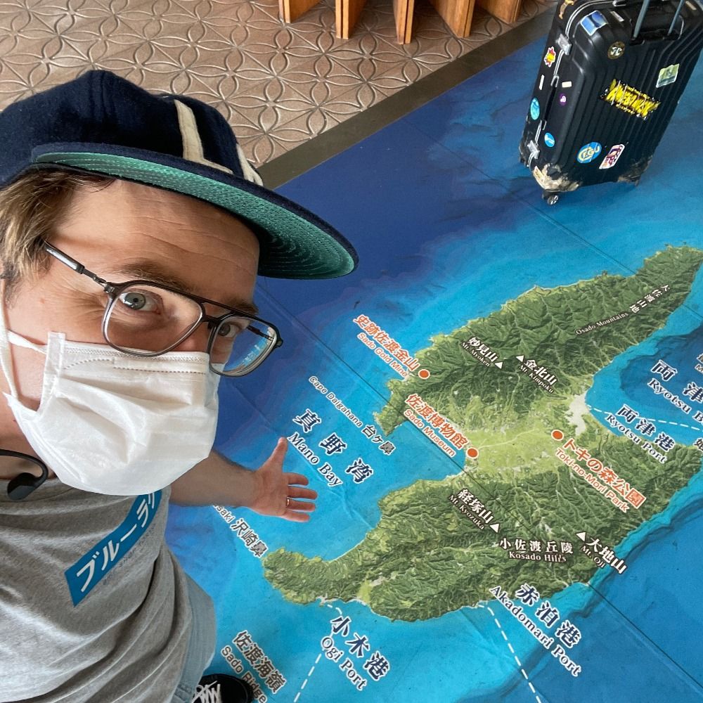
Map of the Noto Peninsula and Sado Island in Central Japan
We'd have loved to share this at #AGU25
With marine terraces (4767 platforms 🖱️💪Nina!) spanning the last Myr we show that the faults of the Noto Peninsula EQ started slipping around 300 ka. A landscape evol. model explains the transient topography of the peninsula. 1/3
doi.org/10.1029/2025...
19.12.2025 16:11 — 👍 13 🔁 4 💬 1 📌 0

The Noto Peninsula overlain with a shapefile of 4767 terrace units.
The digitized marine terrace dataset can be downloaded as a shapefile on Zenodo (🔗 below). 4767 individual platforms distributed across 16 generations from the Atlas of Koike and Machida (2001). Maybe the most extensive erosive terrace record at a single site? 3/3
doi.org/10.5281/zeno...
19.12.2025 16:11 — 👍 2 🔁 0 💬 0 📌 1

Two slope maps of the bathymetry around the Noto Peninsula and Sado Island highlighting the location of a nearshore scarp.
The EQ faults (& scarp) are drowned by the current high stand. Nearby Sado Island shares similar deformation record and is flanked by a similar nearshore scarp. It is the potential location of a large fault system initially suggested by Ota Yoko in 1992 (she was 🎯). 2/3
19.12.2025 16:11 — 👍 2 🔁 1 💬 1 📌 0
Map of the Noto Peninsula and Sado Island in Central Japan
We'd have loved to share this at #AGU25
With marine terraces (4767 platforms 🖱️💪Nina!) spanning the last Myr we show that the faults of the Noto Peninsula EQ started slipping around 300 ka. A landscape evol. model explains the transient topography of the peninsula. 1/3
doi.org/10.1029/2025...
19.12.2025 16:11 — 👍 13 🔁 4 💬 1 📌 0
Very impressive.
Timelapse via #Copernicus Browser
link.dataspace.copernicus.eu/xvxi
09.12.2025 11:18 — 👍 14 🔁 3 💬 1 📌 2

Japan meteorological Agency map showing the shindo intensity.

JMA explanation of the shindo scale
Shaking was strong, up to shindo 6+. I imagine that liquefaction is a bigger concern. We will know more in the morning.
NHK reports 6 injured in Aomori prefecture (falling objects and falls). 2/2
08.12.2025 17:43 — 👍 3 🔁 0 💬 0 📌 0

screen shot of the Japan Meteorological Agency's tsunami advisory with added location of Kushiro and Ofunato

Tide gauge at Kushiro showing tsunami arrival at low tide. Tsunami is ca. 0.25 m.

Tide gauge at Ofunato showing tsunami arrival at low tide. Tsunami is ca. 0.3 m.
Fortunately, the M7.6 earthquake struck at low tide, reducing the impact of the tsunami (itself smaller than feared, max 70cm observed). 1/2
08.12.2025 17:43 — 👍 23 🔁 9 💬 2 📌 0

Current screenshot of Kilauea USGS webcam
Also, you should really check out Kilauea right now! ⚒️🌋
www.youtube.com/live/tk0tfYD...
06.12.2025 21:32 — 👍 29 🔁 6 💬 0 📌 0

Noto coast in Nov. 2023.
Waves come all the way up to a concrete embankment protecting a cliff

Noto Coast after 2 m coseismic uplift.
100 m wide rock platform is now emerged

A road is now built on the bedrock platform, protected by a new sea wall
On Noto Peninsula where coseismic uplift was ~2m.
Sequence pre-earthquake, EQ +3 months, EQ +23 months. I thought we would be able to monitor this nice flat surface for weathering efficiency over the years…
14.11.2025 21:43 — 👍 18 🔁 3 💬 1 📌 0
Noto Earthquake and submarine landscape. After a loooong time looking for reviewers, we received good critical comments which led to notable revisions. Now back in review at GRL hoping that the 2nd round will be shorter than the 6 months of the first: doi.org/10.31223/X53...
30.10.2025 06:59 — 👍 5 🔁 1 💬 0 📌 0
Embark on a journey through the obscure world of forgotten, odd, and obsolete Sony devices.
Associate Professor at Kyoto University/sedimentary geology/morphodynamics/quantitative stratigraphy/geomorphology/turbidity currents/tsunami deposits/Judo
Comedian and writer, year-round iced coffee drinker.
British, But In Las Vegas and NYC
ezitron.76 Sig
Newsletter - wheresyoured.at
https://linktr.ee/betteroffline - podcast w/ iheartradio
Chosen by god, perfected by science
CEO at EZPR.com - Award-Winning Tech PR
Professeur de sciences👨🔬 Animateur dans l'âme⚗️ Fan d'astronomie 🔭 Membre du @cafe_sciences
☕#kidi_Science
📺 https://www.youtube.com/@ProfesseurLouphoque
Health contributor/reporter at Guardian US, contributing editor at the New Republic, freelance elsewhere. Arctic obsessive and book enthusiast.
Email: melodyschreiber@proton.me
Signal: melodyschreiber.06
Newsletter: notadoctor.news
Mostly stoked about science, particularly field geology, active tectonics and subduction zones. Also, road cycling, running and cooking.
Earthquakes, history of science, dogs, travel, democracy, and more. Grandma of 5 boys & 1 spider. Recovering from bird flu.
Ass. Prof. at Université Côte d'Azur - Earth Sciences - Active Tectonics
Associate Prof., Department of Earth Sciences, Chiba Univ.
#geomorphology #paleoseismology #tsunamideposits #tephra #driftpumice
https://orcid.org/0000-0002-4798-3425
https://sites.google.com/view/ishimuradaisukehomepage/english
Journalist. Author. Podcaster. Liberal extremist.
Journalist, podcaster (Origin Story) and author (33 Revolutions Per Minute, The Ministry of Truth, Everything Must Go, Origin Story books). Anti-doomer despite everything. www.dorianlynskey.com
Earthquake/volcano happenings+tidbits, maps, machine learning.
I'm ALomax Scientific: earthquake and volcano monitoring, analysis and research
PhD student, Hokkaido University (北大), Sapporo, Japan
Hurricane inner-core dynamics & observations
Aspiring novelist/singer, nature lover, concertgoer, beach bum, UMiami alum, aracial, nonbinary🌀📡⛈️☀️🌴🦈🌊🐶📚🎸🎤
“It’s a made-up world with real-life consequences”
The real stories behind the most misunderstood and abused ideas in politics. A podcast with Dorian Lynskey and Ian Dunt.
http://patreon.com/originstorypod
Produced by Podmasters
New York Times Opinion writer and New York Times Magazine columnist. Newsletter on climate and the messy future (https://tinyurl.com/dwwnyt). Author of The Uninhabitable Earth.
https://www.nytimes.com/newsletters/david-wallace-wells
De formation en Géographie SIG et Météorologie j'ai aussi travaillé plus de 20 ans en tant qu'ergonome designer et Data Designer. Je suis passionné par les données spatiales et temporelles, par la photo d'animaux. Je travaille pour un ministère régalien.
🇩🇪 born in Graz 🇦🇹, reside & work in Tokyo 🇯🇵.
📍Photographer (Film & Digital)
📍Data Architect
📍Coffee Lover
📍Classic 📽️ Buff
📍Photo Book Hoarder
📍🥁 Apprentice
NFT/AI 🚫
Website: https://www.norbertwoehnl.com
Newsletter: https://buttondown.com/norbertwoehnl
Studying the Earth from ETH Zurich