#sismo #temblor
Las calderas que en estos momentos tienen sismicidad interesante y deformación constante son:
- Laguna del Maule (Chile)
- Campi Flegrei (Italia)
y ahora, #Yellowstone (USA) con un M3.9 a 800m de profundidad focal
Alguna otra que falte por mencionar?
19.08.2025 17:34 — 👍 1 🔁 0 💬 1 📌 0

From EMSC
#Earthquake (#زلزله, #землетрясение) confirmed by seismic data.⚠Preliminary info: M5.2 || 75 km SE of #Fayzabad (#Afghanistan) || 8 min ago (local time 09:49:50). Follow the thread for the updates👇
19.08.2025 05:27 — 👍 1 🔁 2 💬 1 📌 0

Earthquake source parameters
Mw=7.6, DRAKE PASSAGE (Depth: 12 km), 2025/05/02 12:58:26 UTC - Full details here: http://geoscope.ipgp.fr/scripts/seismes/fiche.php?seis=us7000pwkn
02.05.2025 13:38 — 👍 3 🔁 2 💬 0 📌 0
New platform, same passion! 🌋 Just landed on Bluesky and it's time to repopulate my feed—starting with some 'vintage' research! Throwback to our 2024 paper on anisotropic #seismictomography of #EtnaVolcano, unraveling its complex dynamics. Still a hot topic!🔥
#AguPubs #GRL
doi.org/10.1029/2024...
05.03.2025 20:34 — 👍 18 🔁 5 💬 0 📌 0
27.02.2025 13:14 — 👍 1 🔁 0 💬 0 📌 0
Sismo 27 Febrero 2010, Mw 8.8, Chile Central, Piso 10, Santiago.
140 segundos de percepción.
27.02.2025 13:14 — 👍 1 🔁 0 💬 1 📌 0

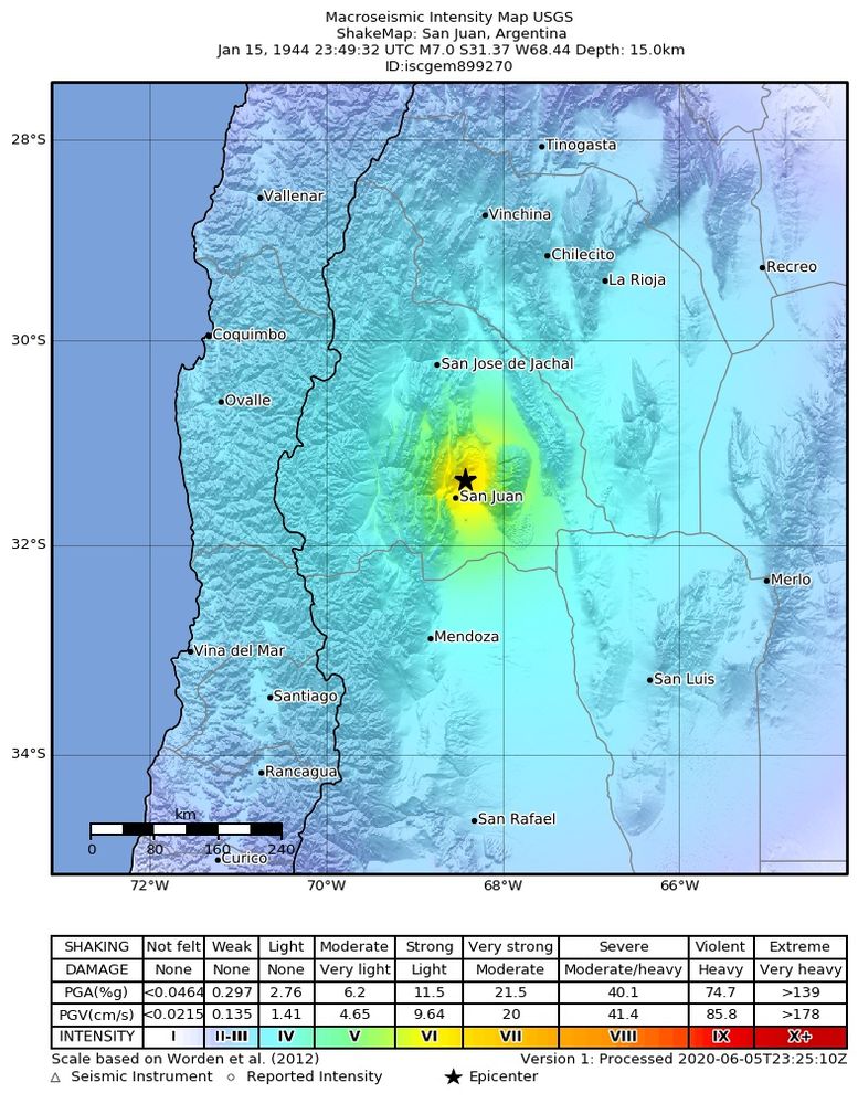
Earthquake intensity map by USGS of the 2010, 27 Feb, M 8.8 Bio-Bio, Chile earthquake.
![Surface projection of the slip distribution superimposed on GEBCO bathymetry. Thick white lines indicate major plate boundaries [Bird, 2003]. Gray circles, if present, are aftershock locations, sized by magnitude.](https://cdn.bsky.app/img/feed_thumbnail/plain/did:plc:ypwk3a2va4sjhf635v2buswn/bafkreih2sigk4jl7al2bkwnop6gy5wlvruksfecuucshaa66wookzvot5i@jpeg)
Surface projection of the slip distribution superimposed on GEBCO bathymetry. Thick white lines indicate major plate boundaries [Bird, 2003]. Gray circles, if present, are aftershock locations, sized by magnitude.
The Feb 27, 2010, M 8.8 Bio-Bio, Chile, #earthquake was caused by shallow thrust faulting along the Nazca and South America plates converging at 71 mm/yr. The fault rupture, over 100 km wide and nearly 500 km long, spread from 25 km deep, causing severe shaking and a tsunami. (1/3) #OTD ⚒🧪
27.02.2025 07:54 — 👍 34 🔁 10 💬 2 📌 0

From EMSC
🔔#Earthquake (#sismo) M4.2 occurred 13 km NW of Acapulco de Juárez (#Mexico) 10 min ago (local time 09:58:19). More info at:
📱https://m.emsc.eu/#app
🌐https://m.emsc.eu/?id=1776716
🖥https://www.emsc-csem.org/Earthquake_information/earthquake.php?id=1776716
26.02.2025 16:08 — 👍 3 🔁 2 💬 1 📌 0

MAJOR SPLIT-TYPE SUDDEN STRATOSPHERIC WARMING IN THE 06Z GFS! 🚨 🤯
Ok, it's at 330 hours, and it's just one member, so this is not a forecast.
BUT, it's inescapable that forecasts are now drifting toward a weaker vortex, consistent with strong wave forcing from the Scandinavia-Greenland pattern.
30.01.2025 15:55 — 👍 51 🔁 6 💬 4 📌 1
From EMSC
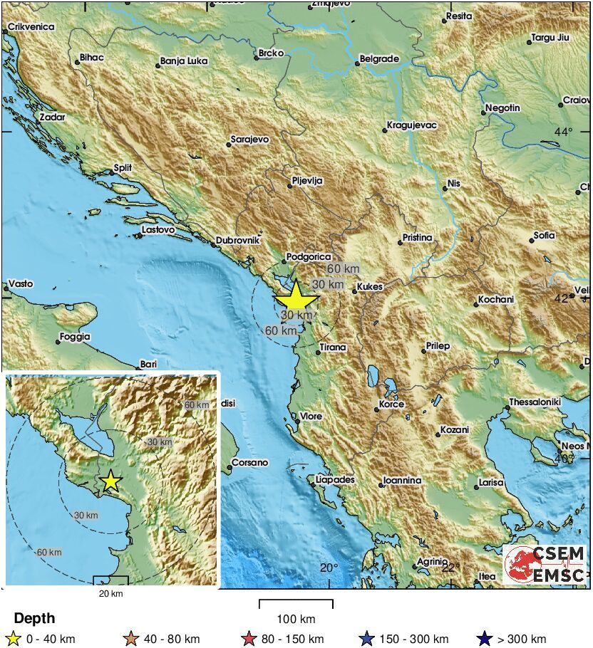
🔔#Earthquake (#tërmet, #земљотрес) M4.4 occurred 16 km S of #Shkodër (#Albania) 2 min ago (local time 14:39:00). More info at:
📱https://m.emsc.eu/#app
🌐https://m.emsc.eu/?id=1760772
🖥https://www.emsc-csem.org/Earthquake_information/earthquake.php?id=1760772
24.01.2025 13:41 — 👍 1 🔁 1 💬 1 📌 0

A M5.8 (local confirmation); M5 .1 USGS. It occurred in Guayaquil-ECU at a depth of 84km and was an interplate EQ. It was a strong tremor due to its depth and epicenter.
Also, I was at the epicenter and I confirm that it was strong as it was interplate and the first +M5 in Ecuador-2025
13.01.2025 04:47 — 👍 2 🔁 1 💬 0 📌 0
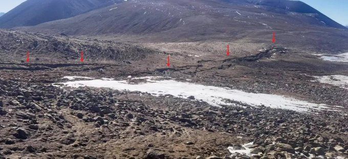
El comunicado con más información técnica se puede consultar en: www.eq-igl.ac.cn/zhxw/info/20...
12.01.2025 03:05 — 👍 1 🔁 0 💬 0 📌 0


#sismo #temblor
El Instituto de Geología, Administración de Terremotos de
#China, ha publicado imágenes de la ruptura en superficie de la falla extensional que generó el reciente sismo M7.1 (USGS) en el sur meseta del Tibet.
Los desplazamientos observados en superficie son de 2 a 3 metros!!
12.01.2025 03:02 — 👍 13 🔁 2 💬 1 📌 0

Is it possible Earth captured the Moon?
Maaaaaaybe. The Giant Impact hypothesis still reigns, but it’s worth looking at other ideas
4.5 billion years ago or so, a planet the size of Mars slammed into Earth and the debris that splashed out eventuially coalesced to form the Moon.
…or did it?
… well, yeah, probably. But a new paper posits Earth-sized planets can capture moons.
badastronomy.beehiiv.com/p/is-it-poss...
🧪🔭
30.12.2024 18:27 — 👍 213 🔁 35 💬 9 📌 3

Early Triassic super-greenhouse climate driven by vegetation collapse
The reduction in terrestrial organic carbon burial and nullication of silicate weathering result in CO₂ levels stabilizing at up to 10,000 ppm..
ui.adsabs.harvard.edu/abs/2023EGUG...
assets-eu.researchsquare.com/files/rs-208...
13.12.2024 22:57 — 👍 68 🔁 23 💬 1 📌 4

Monster wildfires are sending more smoke into the stratosphere
Smoke lofted into the upper atmosphere on towering pyrocumulonimbus clouds can spread around the globe and affect the climate
Monster wildfires are sending more smoke into the stratosphere
Smoke lofted into the upper atmosphere on towering pyrocumulonimbus clouds can spread around the globe and affect the climate
www.newscientist.com/article/2461...
docs.google.com/document/d/1...
23.12.2024 22:16 — 👍 208 🔁 85 💬 6 📌 4
Thank you, President Carter.
Rest in peace.
A short thread on President Carter and energy. 👇 💡🔌
29.12.2024 22:04 — 👍 134 🔁 32 💬 2 📌 0

What happens in China never just stays in China. There is a surge in influenza A in the U.S. as well this winter. We rarely test whether the virus is conventional flu, or H1N1 swine flu, H5N1 bird flu. But the crowded ERs seen in many places are indications something is afoot. 🧵
29.12.2024 13:27 — 👍 715 🔁 327 💬 40 📌 33
100 years of average November temperature anomalies over land areas through 2024...
Data from NOAAGlobalTemp v6.0.0 (www.ncei.noaa.gov/products/lan...)
29.12.2024 22:25 — 👍 88 🔁 40 💬 0 📌 1

Smoke particles from wildfires can erode the ozone layer
csl.noaa.gov/news/2023/37...
docs.google.com/document/d/1...
23.12.2024 23:51 — 👍 221 🔁 77 💬 5 📌 4
'One of the biggest on record'
Ozone hole bigger than North America opens above Antarctica
The hole reached an astounding 26 million square kilometers on September 16, 2023 ― approximately three times the size of Brazil.
x.com/DavidUllrich...
Credit: Copernicus Sentinel-5P satellite
23.12.2024 04:18 — 👍 590 🔁 280 💬 30 📌 23
An old #Chinese #satellite was seen breaking up in the night sky as it entered Earth's #atmosphere over parts of the southern #UnitedStates Saturday night (December 21) w/ numerous reports in #Louisiana #Mississippi and #Arkansas
(WLOX)-TV: "...satellite that came crashing down from the atmosphere"
23.12.2024 00:31 — 👍 2 🔁 2 💬 0 📌 0

Event map showing the location of the earthquake.
Prelim M 4.8, Ethiopia #earthquake (23.12.2024 01:13:55 UTC) at 10.0 km depth.
Check this link for event updates: http://geofon.gfz-potsdam.de/eqinfo/event.php?from=rss&id=gfz2024zcja
23.12.2024 01:28 — 👍 3 🔁 1 💬 0 📌 0
Geophysicist | Postdoc | Exploring Earth & Volcanoes Dynamics at #INGV 🌋 | Animal & Nature Lover 🏞 | Enthusiastic about Traveling and Exploring Cultural Diversity 🌈 | 100% Antifascist, Feminist & Vegetarian 🌱 |
RT alerts for quakes in NC/Vanuatu, Pacific Ocean, East Indian Ocean.
ALL DATE/TIME ARE UTC.
http://www.seisme.nc/
Stations:
https://www.orsnet.org/?page_id=339
#earthquake #seisme #sismo #지진 #地震
Thanks to Geoscience Australia for their constant support :)
Curiosità, news ed articoli sul mondo dei terremoti e dei vulcani.
Profesor Titular UTEM, profesor Asociado IACC. Periodista, ex diplomático. Interesado en avances de la ciencia y la tecnología y su incidencia en temas sociales y educacionales. Desilusionado (pero no desinteresado) de la política contingente.
Geólogo, librero, ahora profe, la vida sigue girando...
Seismologist at European Center for Geodynamics and Seismology (Lux 🇱🇺)
Born in Italy 🤌🏻
Proud European 🇪🇺
Earthquakes | Volcanoes | Nature | Books | Politics
Earth sciences - geology - tectonics - earthquakes - fieldwork - teaching - outreach - Vrije Universiteit Amsterdam - aardbeving - vulkanen - Aardwetenschappen
Also active as
https://bsky.app/profile/berndandeweg.mastodon.nl.ap.brid.gy
Boğaziçi University
Kandilli Observatory and Earthquake Research Institute, Regional Earthquake-Tsunami Monitoring Center
İstanbul, Türkiye 🇹🇷
Seismologist turned fault modeler🧑🏻💻. Taiwanese. Lived and worked on three continents! Former @snsf-ch.bsky.social postdoc.mobility fellow at @eapsmit.bsky.social . Now researcher at ITRI Taiwan.
President of VIENNA goes EUROPE | European Federalist | #StandWithUkraine 💙💛 #RecognizeKosovo
Developing a prototype for a digital twin on geophysical extremes
🇪🇺 HorizonEU project / Led by GEO3BCN_CSIC / Towards #DestinE
🌋 Space weather, earthquakes, auroras
🌵 Twitter: Justice Ginni, Stormy Sessions
❌️👑 American Mafia
🦋 Anti-Fascist
🐸 #Antifa
Survived near death, dementia, homelessness. Healed by camping. 🌞
Passionate about volcanoes, extreme weather & wildfires. If it's exciting, informative, or unique, I'll share it. © to owners! DM for credit/removal/submission.
Studying MPhys Astrophysics with Space Science at The Open University. Aspiring astrobiologist/planetary scientist. FRAS. BSc (Hons) Computing, CertHE Natural Sciences. http://guywatkins.space
#remotesensing @ https://bsky.app/profile/adamplatform.bsky.social
#Climate & #Copernicus Atmospheric Composition training for @eumetsat
@Esa ESAC 2014/15
Former #Copernicus 🇪🇺 Support Office /EMS/DEFIS
#Sentinerd S3B & S6A #Aeolus, #SolarOrbiter #MTGS1
Sterling Professor of Social and Natural Science at Yale University. Sociologist. Network Scientist. Physician. Author of Apollo's Arrow; Blueprint; Connected; and Death Foretold. Director of the Human Nature Lab: https://humannaturelab.net
Prof. Cultura y Literatura Coreanas UCM 🇰🇷 Traductora KO-ES📚🎞 Sin divulgación no hay sentido💫 La de los libros coreanos 💬








![Surface projection of the slip distribution superimposed on GEBCO bathymetry. Thick white lines indicate major plate boundaries [Bird, 2003]. Gray circles, if present, are aftershock locations, sized by magnitude.](https://cdn.bsky.app/img/feed_thumbnail/plain/did:plc:ypwk3a2va4sjhf635v2buswn/bafkreih2sigk4jl7al2bkwnop6gy5wlvruksfecuucshaa66wookzvot5i@jpeg)


