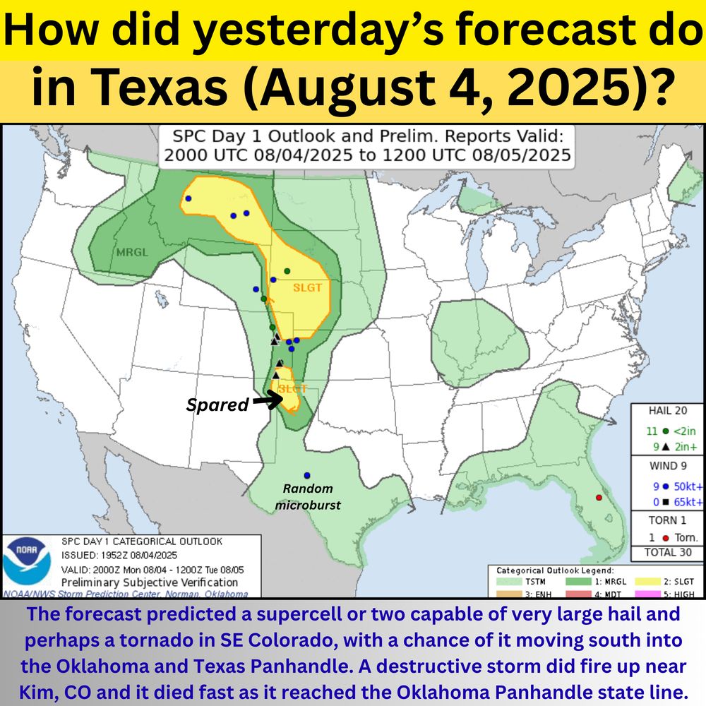
A weather verification graphic titled “How did yesterday’s forecast do in Texas (August 4, 2025)?” shows the SPC Day 1 Outlook and preliminary storm reports from 2000 UTC August 4 to 1200 UTC August 5. The map highlights a Slight Risk (SLGT) area in yellow stretching from southeast Colorado through the Texas Panhandle into north-central Texas, with Marginal Risk (MRGL) areas in surrounding regions. Colored dots mark hail, wind, and tornado reports. Black annotations on the map read “Spared” over the Texas Panhandle and “Random microburst” over west central Texas. A text summary at the bottom explains that a forecasted supercell near Kim, Colorado did develop but weakened as it entered Oklahoma.
Severe storm forecast verification for Monday August 4th (afternoon/evening)
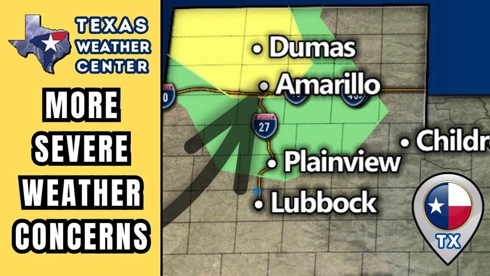
A Slight Risk was in place across the Texas Panhandle yesterday for the threat of a severe storm moving in from the north (Colorado/OK PH), but luckily for Texas this storm died out pretty fast.
05.08.2025 16:26 — 👍 1 🔁 0 💬 0 📌 0
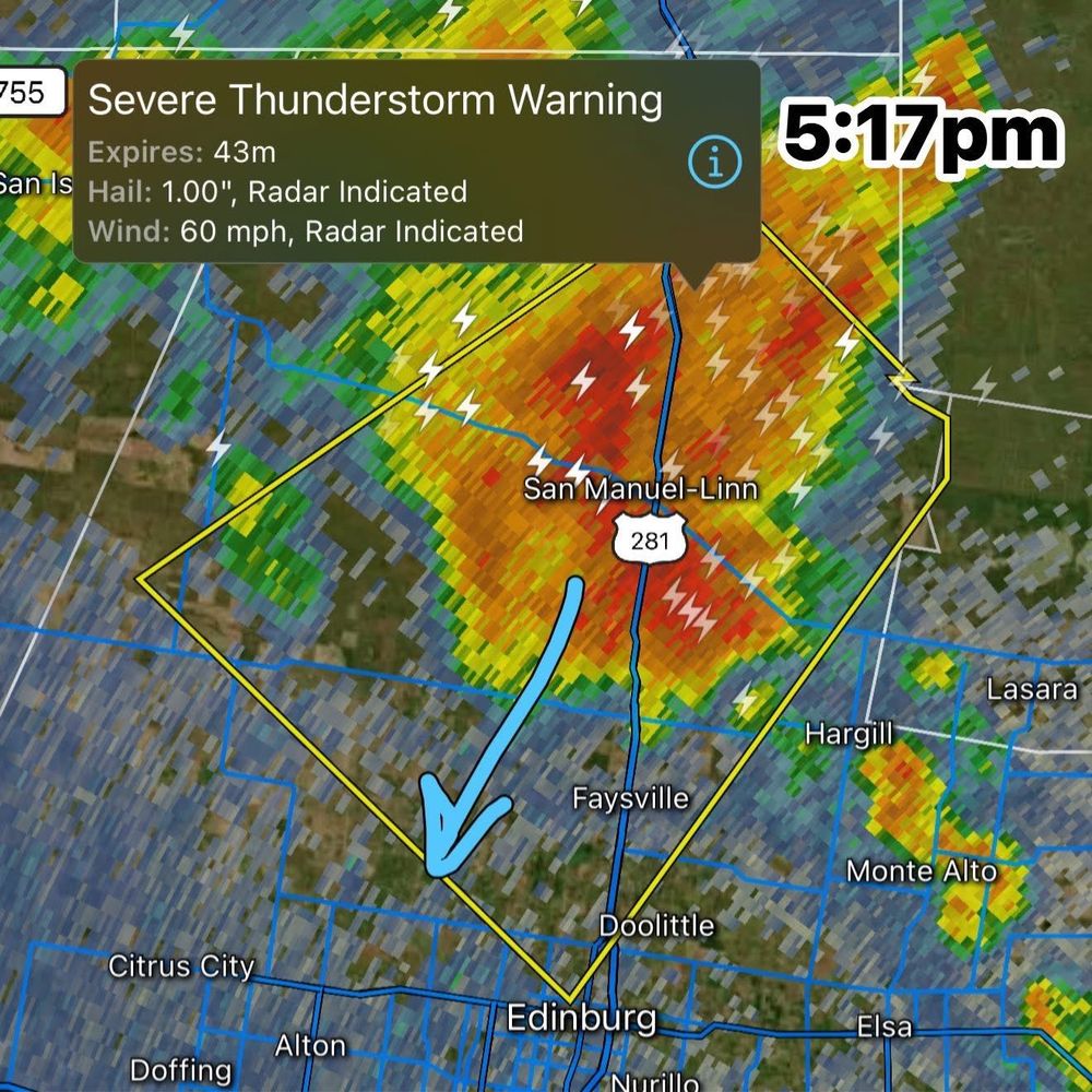
HIDALGO COUNTY - A new Severe Thunderstorm Warning has been reissued for the San Manual-Linn and Faysville TX area for wind gusts up to 60mph and hail up to the size of quarters.
04.08.2025 22:20 — 👍 0 🔁 0 💬 0 📌 0
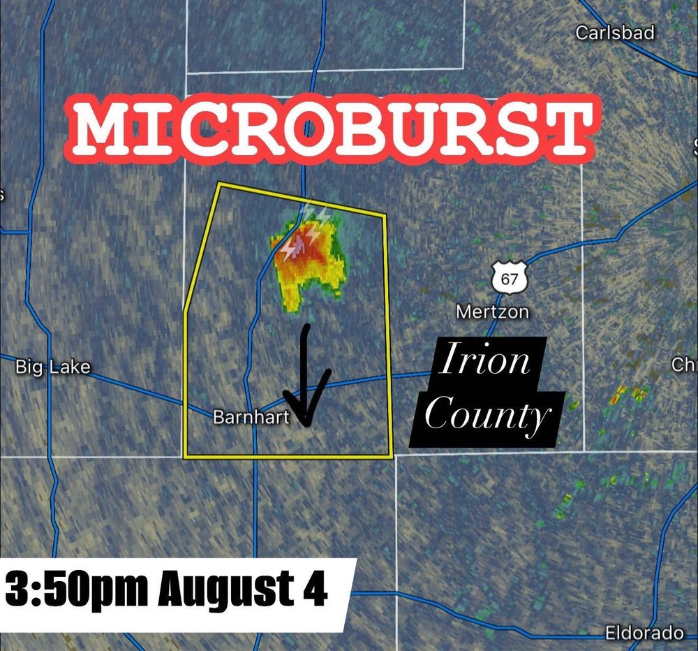
One lone cell has fired up in rural Irion County north of Barnhart TX capable of localized damaging winds. It has a decent microburst signature on radar, and is capable of damaging 60 MPH winds. Storm is moving south.
04.08.2025 20:56 — 👍 5 🔁 0 💬 0 📌 0
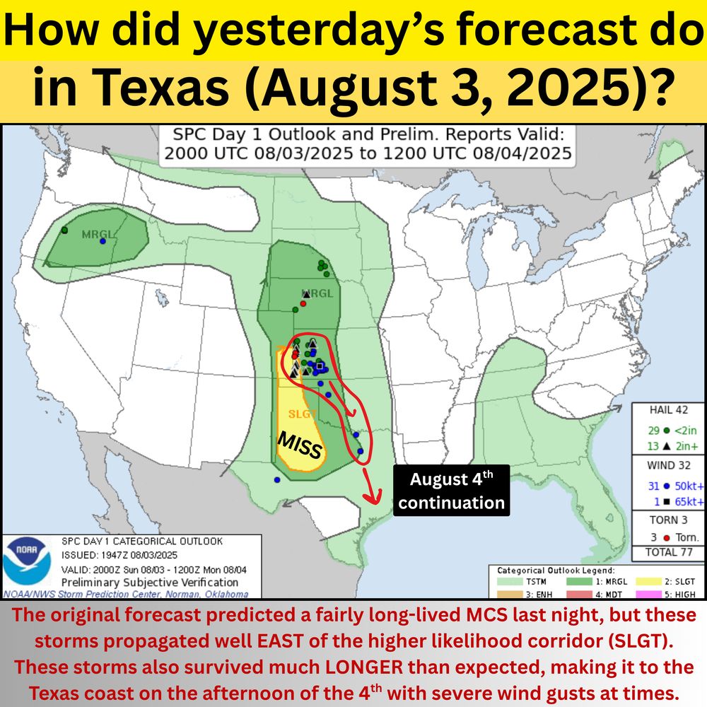
A weather verification graphic titled “How did yesterday’s forecast do in Texas (August 3, 2025)?” shows a Storm Prediction Center Day 1 Outlook map overlaid with storm reports and assessment. The original SLGT (Slight Risk) area missed the main storm activity, which tracked well east of the forecast corridor, labeled “MISS.” An arrow points south toward the Texas coast with a note saying storms continued into August 4th. A caption explains the storms lasted longer than expected and reached the coast with severe wind gusts.
Texas severe storm forecast verification for yesterday August 3rd
Could have been better. The severe storm complex (MCS) unexpectedly turned southeast in SW Kansas toward OKC, then curved more southerly again to reach DFW and even Houston this morning. It did ride on the eastern edge of the Marg...
04.08.2025 18:57 — 👍 4 🔁 0 💬 0 📌 0
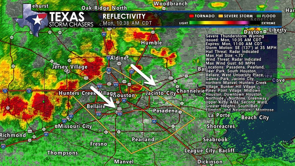
Radar image of a severe thunderstorm moving southeast through the Houston Metro at 10:38 AM CDT on August 4. Storm is impacting areas like Bellaire, Jacinto City, and Pasadena with 60 MPH wind gusts. White arrows indicate storm motion direction. Severe Thunderstorm Warning text overlay is visible.
A strong storm is pushing southeast through the Houston Metro, including Downtown, Bellaire, Jacinto City, Pasadena, and Pearland. A Severe Thunderstorm Warning is in effect until 11:00 AM.
Main threat: 60 MPH wind gusts
Localized damage to trees, roofs, and power lines is possible.
#TXwx
04.08.2025 15:40 — 👍 0 🔁 0 💬 0 📌 0

A complex of severe storms is moving through College Station, Anderson and Shiro #Texas with damaging wind gusts possible! These storms just won’t quit, and may threaten the Houston metro later this morning.
04.08.2025 13:57 — 👍 4 🔁 0 💬 0 📌 0

A microburst is a sudden, powerful downdraft of wind that descends from a thunderstorm and spreads out rapidly when it hits the ground. Microbursts typically last only a few minutes but can be extremely dangerous, especially to aircraft during takeoff or landing.
Good Morning! Did You Know?
04.08.2025 13:01 — 👍 1 🔁 0 💬 0 📌 0
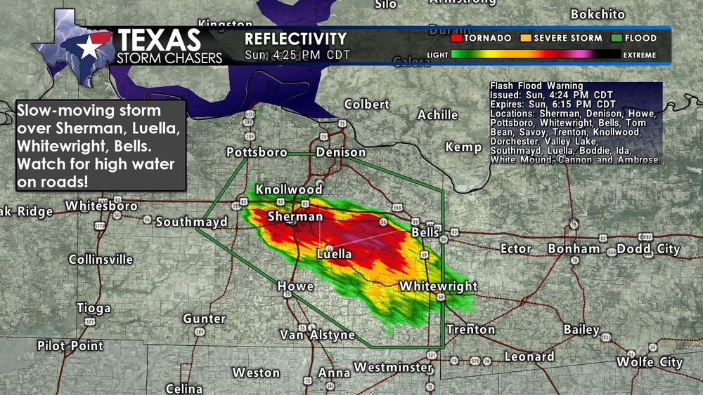
Radar image showing a strong storm producing heavy rain over Sherman, Luella, Whitewright, and Bells in southeastern Grayson County, Texas, at 4:25 PM CDT. Flash Flood Warning is in effect, with up to 2.5 inches of rainfall possible. A text box warns of high water on roads.
427PM: A slow-moving storm is producing very heavy rainfall over Sherman, Luella, Whitewright, and Bells in North Texas. A Flash Flood Warning is in effect until 6:15 PM. Watch for high water on roads, especially in poor drainage areas.
Radar estimates 1–2.5" of rain per hour with more on the way.
03.08.2025 21:28 — 👍 3 🔁 0 💬 0 📌 0
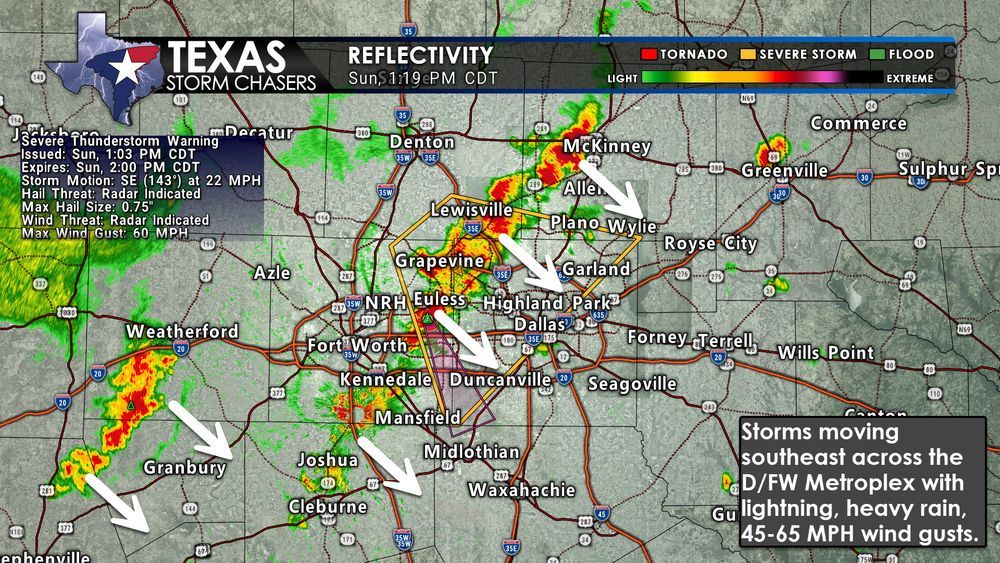
Radar image showing a line of strong storms moving southeast through the Dallas/Fort Worth Metroplex at 1:19 PM CDT on August 3, 2025. The image highlights wind gust threats up to 60 MPH, heavy rain, and frequent lightning. White arrows point to the general southeastward motion of the storms.
121PM: Storms are moving southeast across the D/FW Metroplex early this afternoon. Expect cloud-to-ground lightning, very heavy rain, and wind gusts of 45–65 MPH as they pass through. These storms are not severe for everyone, but gusty winds and brief flooding are possible. #TXwx
03.08.2025 18:22 — 👍 3 🔁 1 💬 0 📌 0

Interactive Weather Radar
Stay informed about Texas weather with our interactive radar. Track storms and monitor precipitation levels for reliable real-time updates to keep you safe.
However, last night’s storms may have left a rain-cooled airmass, limiting today's storm potential. We might not see widespread issues unless the atmosphere can recover.
Stay weather-aware just in case, and check our live radar if storms start firing:
👉 texasstormchasers.com/radar
#TXwx
03.08.2025 16:43 — 👍 1 🔁 0 💬 0 📌 0
Interactive Weather Radar
Stay informed about Texas weather with our interactive radar. Track storms and monitor precipitation levels for reliable real-time updates to keep you safe.
There is a conditional risk for scattered severe storms later today. If storms are able to develop, they could bring:
• Large hail (up to tennis ball size)
• Localized damaging winds (60–75 MPH)
• Heavy rain
03.08.2025 16:43 — 👍 1 🔁 0 💬 1 📌 0
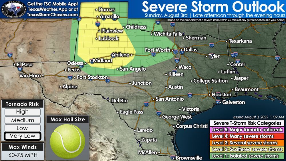
Severe Storm Risk Today – Sunday, August 3
Texas Panhandle • West Texas • Permian Basin • Big Country
🕓 Late Afternoon through Tonight
03.08.2025 16:43 — 👍 2 🔁 0 💬 1 📌 0
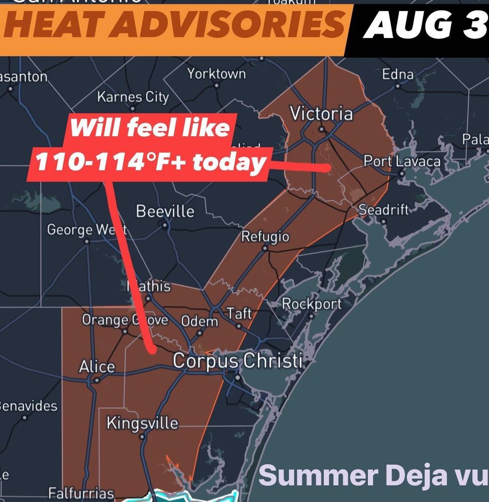
Repeat! Heat Advisories are out again today from Noon to 7 PM for the same places as yesterday from Alice to Victoria TX as the heat index will surpass 110°F across the area this afternoon. Port Lavaca already has a heat index of 110°F as of 10:30am — Gross! #txwx
03.08.2025 15:41 — 👍 3 🔁 0 💬 0 📌 0
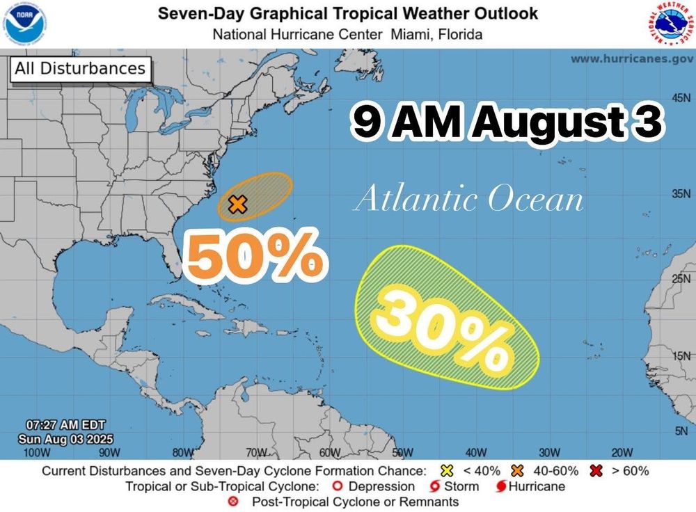
Tracking the #Tropics: Invest 95L off the coast of the NC Outer Banks now has a 50% chance of forming into a named storm by tomorrow. Another area to watch is further east in the tropical Atlantic where there is a 30% chance of formation over the next week.
03.08.2025 14:46 — 👍 8 🔁 1 💬 0 📌 1
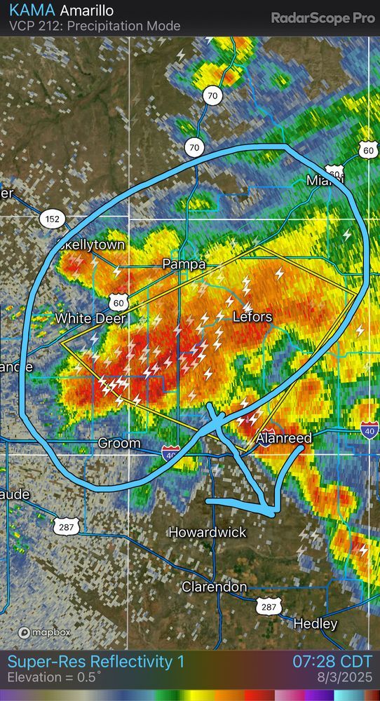
735AM: Severe storm moving south and about to cross I-40 from Groom to Alanreed with damaging winds and hail. Storms also moving south across Northwest Texas with gusty winds, lightning, heavy rain. More storms later today and tonight! #txwx
03.08.2025 12:36 — 👍 2 🔁 0 💬 0 📌 0
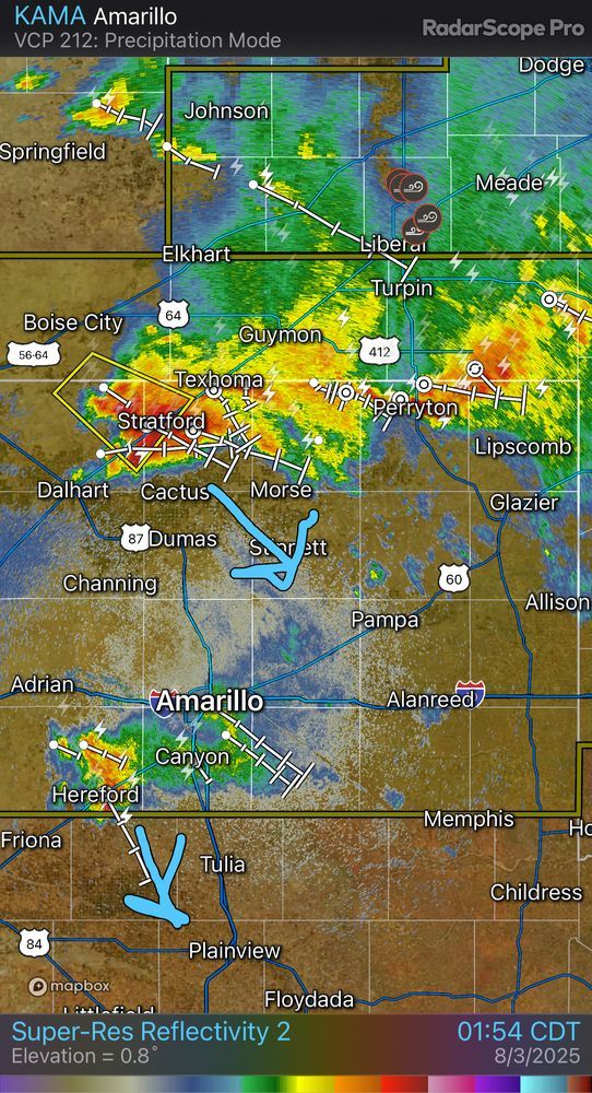
2 AM check-in! A severe storm is over Stratford with damaging winds moving southeast at 25 mph toward Cactus. Other storms east of Perryton are also moving southeast. Stronger storms pose a wind and hail risk. RADAR: texasstormchasers.com/radar #txwx
03.08.2025 07:02 — 👍 1 🔁 0 💬 0 📌 0

🚨 ADRIAN, TX — A nasty supercell capable of 2.75” baseball sized hail and 70 MPH gusts is arriving shortly from the northwest! Get the cars in the garage and don’t get caught outside in it! #txwx
03.08.2025 05:23 — 👍 2 🔁 1 💬 0 📌 0

📞🚨 Rest easy knowing we will call you if a #tornado, destructive storm, or flash #flood emergency is threatening your location with our personalized alert service through WeatherCall NexGen: bit.ly/3CAqCUw
03.08.2025 00:36 — 👍 2 🔁 1 💬 0 📌 0
3:19pm - Strong to severe wind gusts along I-35 between Belton and Temple, and along Route-317 from Belton to Morgan’s Point. A 60mph gust was measured.
02.08.2025 20:23 — 👍 3 🔁 2 💬 0 📌 0
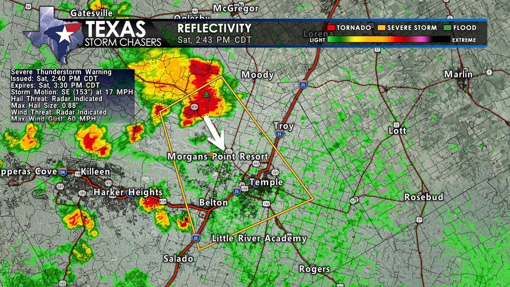
Radar image showing a severe thunderstorm warning in northeastern Bell County, Texas, valid until 3:30 PM CDT. The storm is moving southeast at 17 MPH with winds up to 60 MPH and hail up to 0.88 inches. Notable locations include Temple, Belton, Morgan's Point Resort, and Belton Lake. Radar timestamp is 2:43 PM CDT.
⏰ 2:45 PM CDT – A Severe Thunderstorm Warning is in effect for northeastern Bell County in Central Texas until 3:30 PM. A strong storm near Morgan's Point Resort is moving southeast toward Belton and Temple with 60 MPH wind gusts and nickel-size hail possible.
#TXwx
02.08.2025 19:45 — 👍 1 🔁 0 💬 0 📌 0
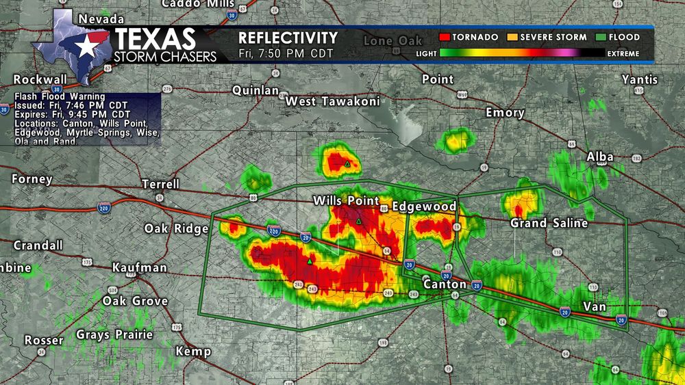
Radar image at 7:50 PM CDT showing heavy rain over parts of eastern Kaufman and northwestern Van Zandt counties. A Flash Flood Warning is in effect for Wills Point, Edgewood, and Canton. Intense red and yellow radar returns show heavy rainfall where 2.5 inches has already fallen. Green outline marks the flash flood warning zone.
7:50 PM Update – North Texas:
Flash Flood Warning for eastern Kaufman County and northwestern Van Zandt County until 9:45 PM. Radar estimates up to 2.5” of rain near Canton, Wills Point, and Edgewood. Flash flooding is likely or ongoing — avoid flooded roads.
📡 texasstormchasers.com/radar
#TXwx
02.08.2025 00:52 — 👍 3 🔁 1 💬 0 📌 0
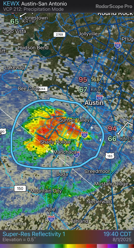
7:45 PM: Stationary storm with heavy rain over southwest Austin, Sunset Valley, and Shady Hollow. Gusty winds and street flooding are likely. When thunder roars, go indoors! #txwx
02.08.2025 00:49 — 👍 3 🔁 0 💬 1 📌 0
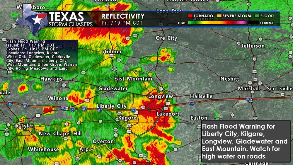
Radar image at 7:19 PM CDT showing heavy rain and flash flood warning for parts of Gregg, Rusk, and Upshur Counties in East Texas. Cities impacted include Longview, Kilgore, Gladewater, Liberty City, and East Mountain. Green outline indicates flash flood warning area. Red/yellow radar returns show very heavy rainfall over urban areas.
7:19 PM Update: A Flash Flood Warning is in effect for Longview, Kilgore, Gladewater, Liberty City, and East Mountain. Heavy rain is causing flooding in low spots—don’t drive through water-covered roads. #TXwx #TXFlood
📡 Track radar at texasstormchasers.com/radar
02.08.2025 00:21 — 👍 1 🔁 0 💬 0 📌 0
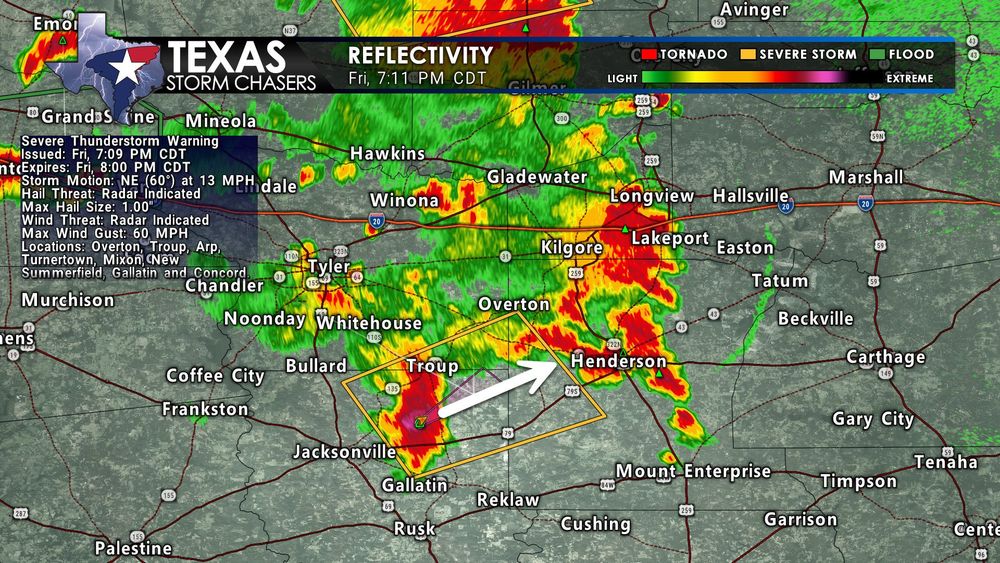
Radar reflectivity from 7:11 PM CDT shows a severe thunderstorm moving northeast through parts of northeastern Cherokee County and southeastern Smith County in East Texas. The storm is approaching Troup and heading toward Overton and Arp. A severe thunderstorm warning is in effect with potential for quarter-size hail and 60 MPH wind gusts.
7:11 PM Update: A severe storm near Troup is pushing northeast toward Overton, Arp, and Henderson. This storm may bring quarter-size hail and 60 MPH winds. Stay indoors and away from windows if you're in the warning!
📡 Track storms live at texasstormchasers.com/radar
02.08.2025 00:13 — 👍 0 🔁 0 💬 0 📌 0
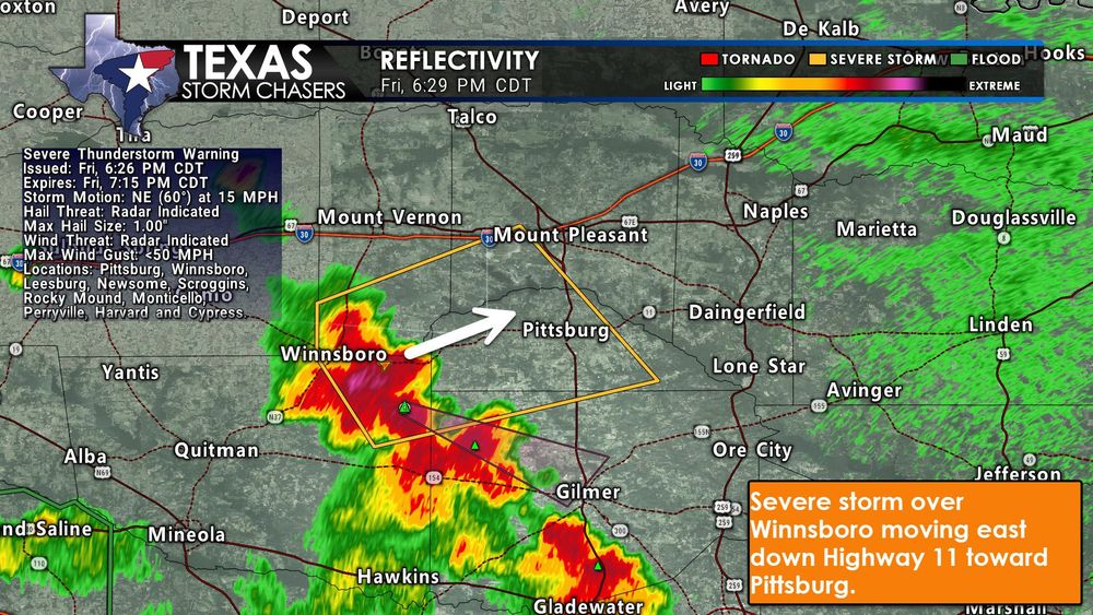
Radar image as of 6:29 PM CDT shows a severe thunderstorm near Winnsboro, TX, moving northeast toward Pittsburg along Highway 11. The storm is within a Severe Thunderstorm Warning area outlined in yellow, with radar reflectivity indicating strong intensity. Locations such as Leesburg, Newsome, Scroggins, and Gilmer are nearby.
📢 Social Media Post (6:30 PM Update):
6:30 PM Update: A severe storm over Winnsboro is moving east along Highway 11 toward Pittsburg. This storm may produce quarter-size hail and heavy rain. Seek shelter if you're in the warning area!
📡 Track it live: texasstormchasers.com/radar #TXwx
01.08.2025 23:32 — 👍 3 🔁 0 💬 0 📌 0
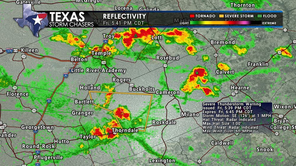
Radar image from 5:41 PM CDT on Friday, August 1, showing a severe thunderstorm warning for west-central Milam and south-central Bell Counties in Central Texas. A strong storm near Granger Dam is nearly stationary, producing quarter-size hail and wind gusts up to 60 MPH. Highlighted warning polygon covers areas near Thorndale, Bartlett, and Buckholts. Storms are scattered across Central Texas with ongoing rain and thunderstorm activity.
5:45 PM Update:
A nearly stationary severe storm near Granger Dam is producing quarter-size hail and 60 MPH winds. Areas impacted include parts of Milam and Bell Counties — near Thorndale, Bartlett, Buckholts, and Davilla. Slow storm movement means localized flooding is possible. #txwx
01.08.2025 22:43 — 👍 2 🔁 0 💬 0 📌 0
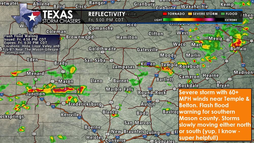
Radar image showing strong thunderstorms across Central Texas at 5:00 PM CDT on Friday, August 1. A severe thunderstorm is located near Temple and Belton, producing 60+ MPH winds. A flash flood warning is in effect for southern Mason County due to slow-moving storms with heavy rain. Additional storm activity is noted near Junction and Blanco. Text box highlights storm motion and safety messaging.
⏰ 5 PM Update – Friday, August 1
⚠️ Severe Thunderstorm Warning for the Temple–Belton area. A storm is crawling north at 5 MPH with 60+ MPH winds and small hail possible.
🌧️ Flash Flood Warning continues for southern Mason County, where 1–2.5 inches of rain has already fallen. #TXwx
01.08.2025 22:04 — 👍 2 🔁 0 💬 0 📌 0
⚠️ A Flash Flood Warning is in effect for southeastern Wichita County in northern Texas until 430 PM CDT.
01.08.2025 18:33 — 👍 3 🔁 1 💬 0 📌 1
Join this channel to get access to perks:
https://www.youtube.com/channel/UCoIfgmxArIATc2EpHD3W9EA/join
Download our FREE Weather App: https://texasweather.app/
Check out the links to our website &…
Storms Multiply across Texas Today & This Weekend
Happy Friday folks! Yes, storms are in the forecast, here is the latest: youtu.be/0mq9DfTjncg
01.08.2025 15:36 — 👍 1 🔁 0 💬 0 📌 0