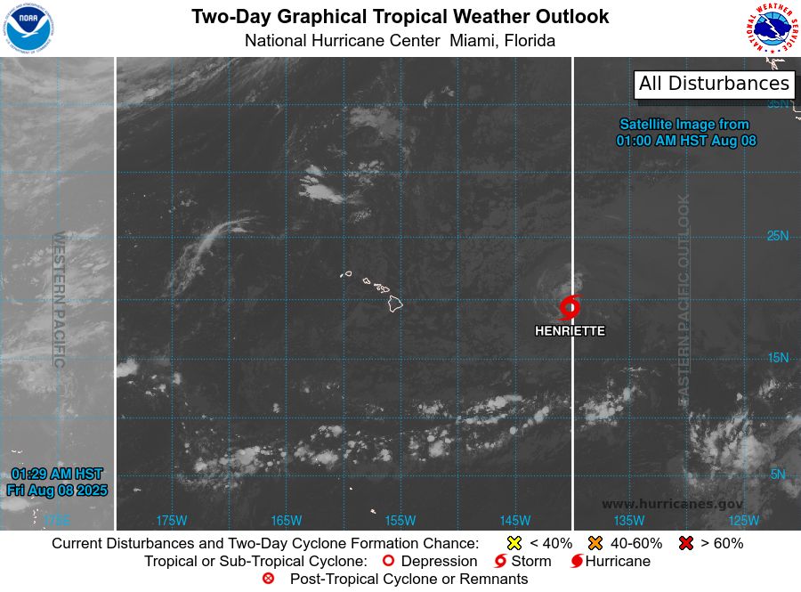
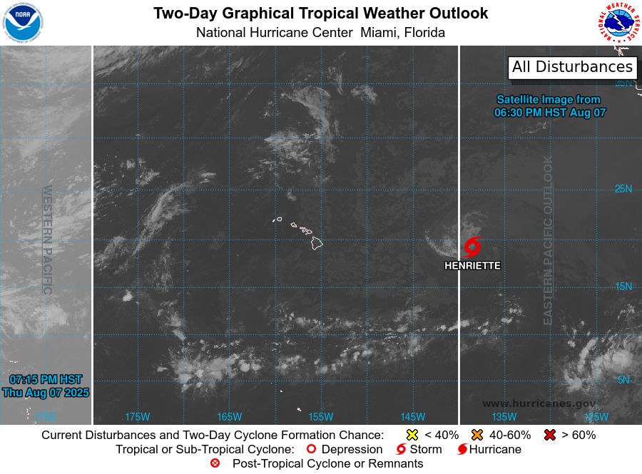
tropical weather outlook over the next 2 days greyscale satellite image of Central Pacific Ocean for
NWS Central Pacific Hurricane Center Honolulu HI
Issued by NWS National Hurricane Center Miami FL
200 AM HST Fri Aug 08 2025
For the central North Pacific...between 140W and 180W:
Active Systems:
The National Hurricane Center is issuing advisories on Tropical
Storm Henriette, located in the Central Pacific basin well east of
the Hawaiian Islands. The National Hurricane Center is also issuing
advisories on Tropical Storm Ivo, located over the Eastern Pacific
basin about 160 miles south of the southern tip of the Baja
California peninsula.
Tropical cyclone formation is not expected during the next 7 days.
$$
Forecaster Hagen
NNNN
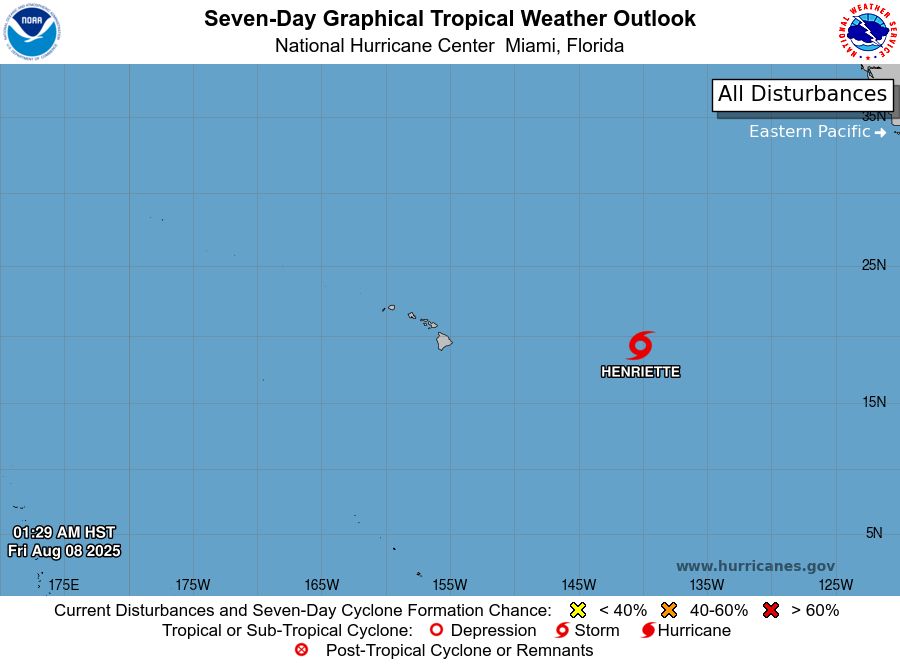
tropical weather outlook over the next 7 days color illustrated image of Central Pacific Ocean for
NWS Central Pacific Hurricane Center Honolulu HI
Issued by NWS National Hurricane Center Miami FL
200 AM HST Fri Aug 08 2025
For the central North Pacific...between 140W and 180W:
Active Systems:
The National Hurricane Center is issuing advisories on Tropical
Storm Henriette, located in the Central Pacific basin well east of
the Hawaiian Islands. The National Hurricane Center is also issuing
advisories on Tropical Storm Ivo, located over the Eastern Pacific
basin about 160 miles south of the southern tip of the Baja
California peninsula.
Tropical cyclone formation is not expected during the next 7 days.
$$
Forecaster Hagen
NNNN
NWS Central Pacific Hurricane Center Honolulu HI
Issued by NWS National Hurricane Center Miami FL
200 AM HST Fri Aug 08 2025
For the central North Pacific...between 140W and 180W:
Active Systems:
The National Hurricane Center is issuing advisories on Tropical
Storm Henriette, located in the Centra
08.08.2025 12:15 — 👍 2 🔁 0 💬 0 📌 0
tropical weather outlook over the next 2 days greyscale satellite image of Central Pacific Ocean for
NWS Central Pacific Hurricane Center Honolulu HI
Issued by NWS National Hurricane Center Miami FL
800 PM HST Thu Aug 07 2025
For the central North Pacific...between 140W and 180W:
Active Systems:
The National Hurricane Center is issuing advisories on Tropical
Storm Henriette, located well east of the Hawaiian Islands.
Henriette is expected to move into the Central Pacific basin later
tonight. The National Hurricane Center is also issuing advisories on
Tropical Storm Ivo, located over the eastern Pacific offshore of the
coast of West-Central Mexico.
Tropical cyclone formation is not expected during the next 7 days.
$$
Forecaster Jelsema
NNNN
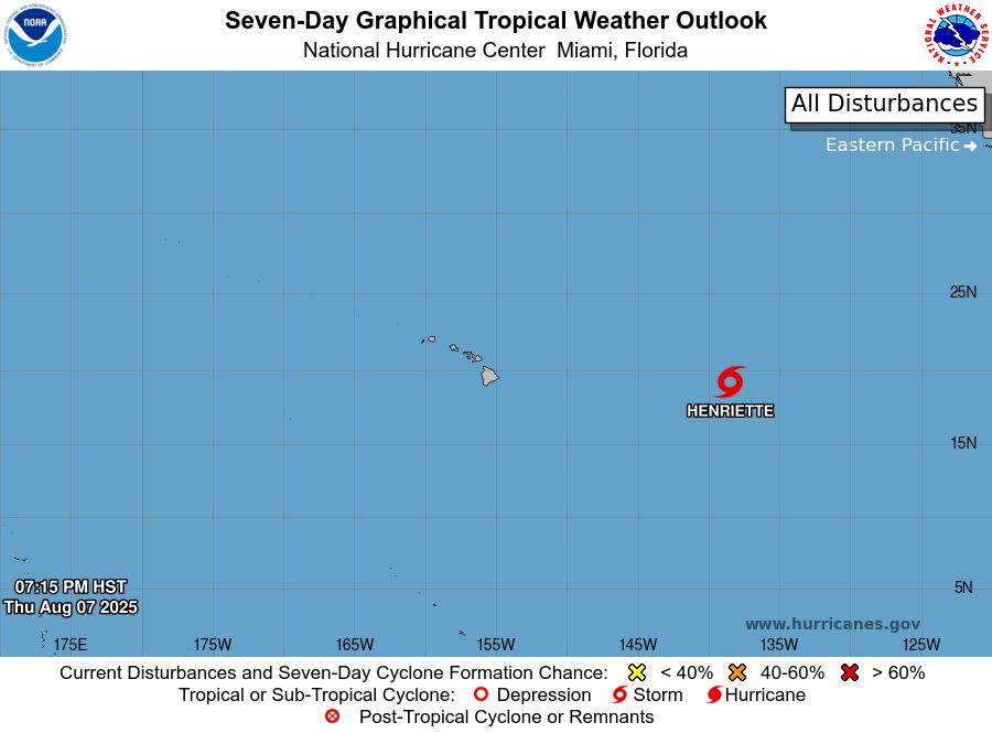
tropical weather outlook over the next 7 days color illustrated image of Central Pacific Ocean for
NWS Central Pacific Hurricane Center Honolulu HI
Issued by NWS National Hurricane Center Miami FL
800 PM HST Thu Aug 07 2025
For the central North Pacific...between 140W and 180W:
Active Systems:
The National Hurricane Center is issuing advisories on Tropical
Storm Henriette, located well east of the Hawaiian Islands.
Henriette is expected to move into the Central Pacific basin later
tonight. The National Hurricane Center is also issuing advisories on
Tropical Storm Ivo, located over the eastern Pacific offshore of the
coast of West-Central Mexico.
Tropical cyclone formation is not expected during the next 7 days.
$$
Forecaster Jelsema
NNNN
NWS Central Pacific Hurricane Center Honolulu HI
Issued by NWS National Hurricane Center Miami FL
800 PM HST Thu Aug 07 2025
For the central North Pacific...between 140W and 180W:
Active Systems:
The National Hurricane Center is issuing advisories on Tropical
Storm Henriette, located well east of
08.08.2025 06:14 — 👍 0 🔁 0 💬 0 📌 0
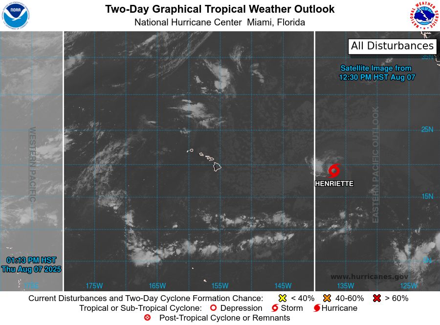
tropical weather outlook over the next 2 days greyscale satellite image of Central Pacific Ocean for
NWS Central Pacific Hurricane Center Honolulu HI
Issued by NWS National Hurricane Center Miami FL
200 PM HST Thu Aug 07 2025
For the central North Pacific...between 140W and 180W:
Active Systems:
The National Hurricane Center is issuing advisories on Tropical
Storm Henriette, located well east of the Hawaiian Islands.
Henriette is expected to move into the Central Pacific basin by
tonight. The National Hurricane Center is also issuing
advisories on Tropical Storm Ivo, located over the eastern
Pacific offshore of the coast of Southwestern Mexico.
Tropical cyclone formation is not expected during the next 7 days.
$$
Forecaster Jelsema
NNNN
tropical weather outlook over the next 7 days color illustrated image of Central Pacific Ocean for
NWS Central Pacific Hurricane Center Honolulu HI
Issued by NWS National Hurricane Center Miami FL
200 PM HST Thu Aug 07 2025
For the central North Pacific...between 140W and 180W:
Active Systems:
The National Hurricane Center is issuing advisories on Tropical
Storm Henriette, located well east of the Hawaiian Islands.
Henriette is expected to move into the Central Pacific basin by
tonight. The National Hurricane Center is also issuing
advisories on Tropical Storm Ivo, located over the eastern
Pacific offshore of the coast of Southwestern Mexico.
Tropical cyclone formation is not expected during the next 7 days.
$$
Forecaster Jelsema
NNNN
NWS Central Pacific Hurricane Center Honolulu HI
Issued by NWS National Hurricane Center Miami FL
200 PM HST Thu Aug 07 2025
For the central North Pacific...between 140W and 180W:
Active Systems:
The National Hurricane Center is issuing advisories on Tropical
Storm Henriette, located well east of
08.08.2025 00:39 — 👍 0 🔁 0 💬 0 📌 0
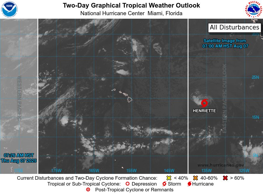
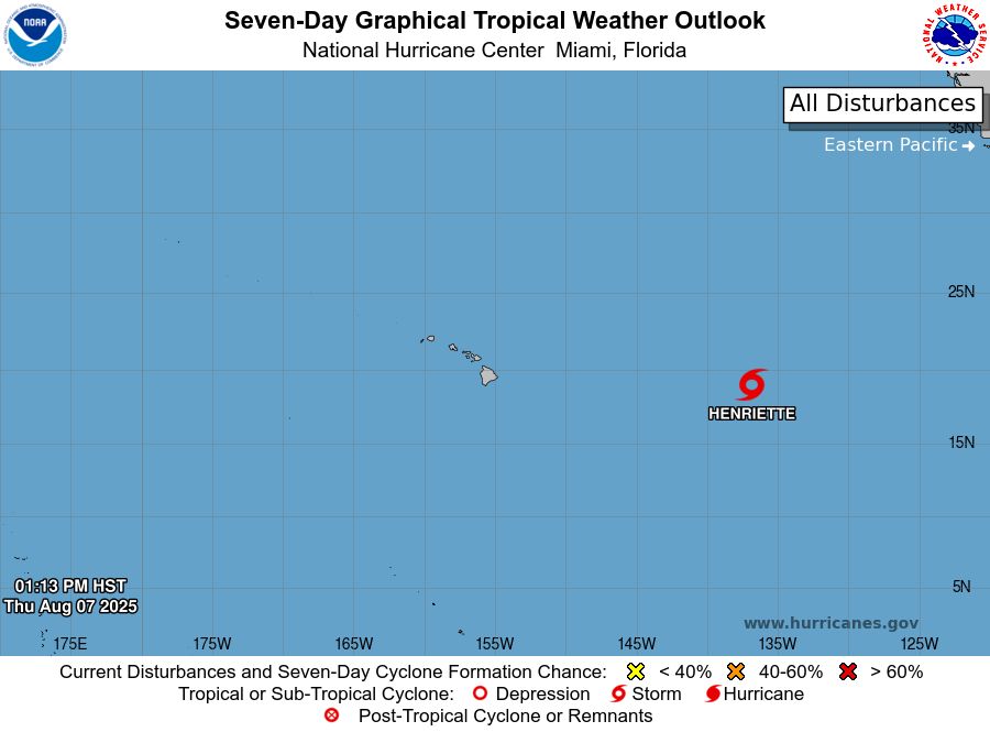
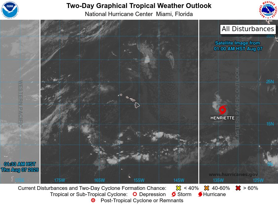
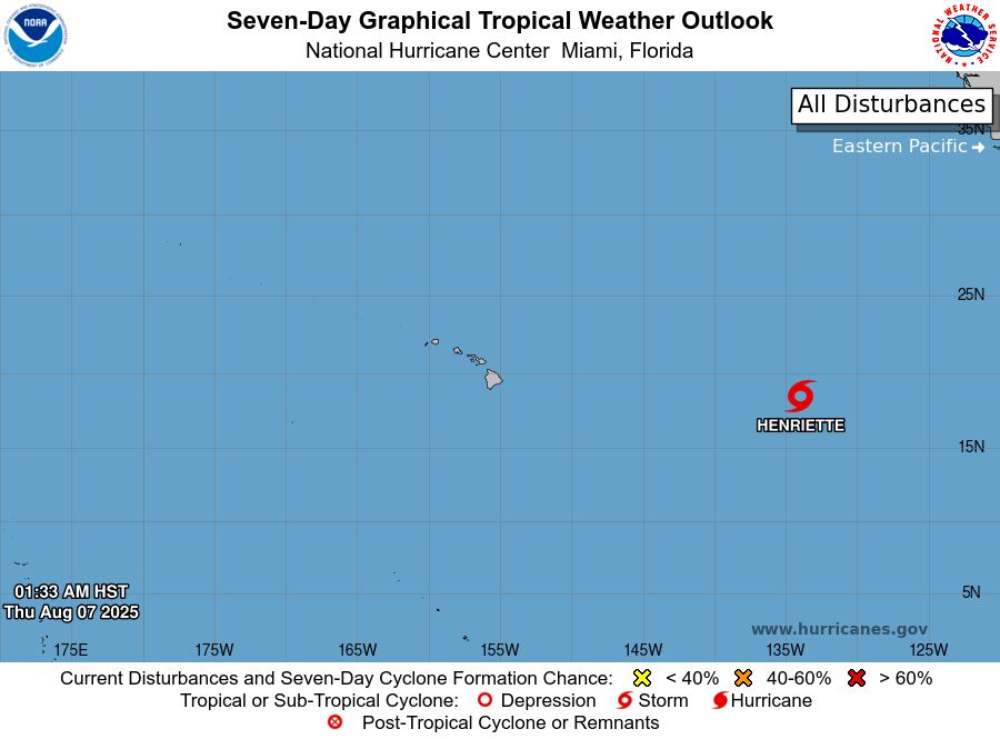
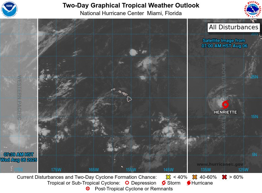
tropical weather outlook over the next 2 days greyscale satellite image of Central Pacific Ocean for
NWS Central Pacific Hurricane Center Honolulu HI
Issued by NWS National Hurricane Center Miami FL
800 AM HST Thu Aug 07 2025
For the central North Pacific...between 140W and 180W:
Active Systems:
The National Hurricane Center is issuing advisories on Tropical
Storm Henriette, located well east of the Hawaiian Islands.
Henriette is expected to move into the Central Pacific basin by
tonight. The National Hurricane Center is also issuing
advisories on Tropical Storm Ivo, located over the eastern
Pacific offshore of the coast of Southwestern Mexico.
Tropical cyclone formation is not expected during the next 7 days.
&&
Public Advisories on Tropical Storm Ivo are issued under WMO
header WTPZ34 KNHC and under AWIPS header MIATCPEP4.
Forecast/Advisories on Tropical Storm Ivo are issued under
WMO header WTPZ24 KNHC and under AWIPS header MIATCMEP4.
$$
Forecaster Papin
NNNN

tropical weather outlook over the next 7 days color illustrated image of Central Pacific Ocean for
NWS Central Pacific Hurricane Center Honolulu HI
Issued by NWS National Hurricane Center Miami FL
800 AM HST Thu Aug 07 2025
For the central North Pacific...between 140W and 180W:
Active Systems:
The National Hurricane Center is issuing advisories on Tropical
Storm Henriette, located well east of the Hawaiian Islands.
Henriette is expected to move into the Central Pacific basin by
tonight. The National Hurricane Center is also issuing
advisories on Tropical Storm Ivo, located over the eastern
Pacific offshore of the coast of Southwestern Mexico.
Tropical cyclone formation is not expected during the next 7 days.
&&
Public Advisories on Tropical Storm Ivo are issued under WMO
header WTPZ34 KNHC and under AWIPS header MIATCPEP4.
Forecast/Advisories on Tropical Storm Ivo are issued under
WMO header WTPZ24 KNHC and under AWIPS header MIATCMEP4.
$$
Forecaster Papin
NNNN
NWS Central Pacific Hurricane Center Honolulu HI
Issued by NWS National Hurricane Center Miami FL
800 AM HST Thu Aug 07 2025
For the central North Pacific...between 140W and 180W:
Active Systems:
The National Hurricane Center is issuing advisories on Tropical
Storm Henriette, located well east of
07.08.2025 18:12 — 👍 1 🔁 0 💬 0 📌 0
tropical weather outlook over the next 2 days greyscale satellite image of Central Pacific Ocean for
NWS Central Pacific Hurricane Center Honolulu HI
Issued by NWS National Hurricane Center Miami FL
200 AM HST Thu Aug 07 2025
For the central North Pacific...between 140W and 180W:
Active Systems:
The National Hurricane Center is issuing advisories on Tropical
Storm Henriette, located well east of the Hawaiian Islands.
Henriette is expected to move into the Central Pacific basin
Thursday night. The National Hurricane Center is also issuing
advisories on Tropical Storm Ivo, located offshore of the coast of
Southwestern Mexico.
Tropical cyclone formation is not expected during the next 7 days.
&&
Public Advisories on Tropical Storm Ivo are issued under WMO
header WTPZ34 KNHC and under AWIPS header MIATCPEP4.
Forecast/Advisories on Tropical Storm Ivo are issued under
WMO header WTPZ24 KNHC and under AWIPS header MIATCMEP4.
$$
Forecaster Papin
NNNN
tropical weather outlook over the next 7 days color illustrated image of Central Pacific Ocean for
NWS Central Pacific Hurricane Center Honolulu HI
Issued by NWS National Hurricane Center Miami FL
200 AM HST Thu Aug 07 2025
For the central North Pacific...between 140W and 180W:
Active Systems:
The National Hurricane Center is issuing advisories on Tropical
Storm Henriette, located well east of the Hawaiian Islands.
Henriette is expected to move into the Central Pacific basin
Thursday night. The National Hurricane Center is also issuing
advisories on Tropical Storm Ivo, located offshore of the coast of
Southwestern Mexico.
Tropical cyclone formation is not expected during the next 7 days.
&&
Public Advisories on Tropical Storm Ivo are issued under WMO
header WTPZ34 KNHC and under AWIPS header MIATCPEP4.
Forecast/Advisories on Tropical Storm Ivo are issued under
WMO header WTPZ24 KNHC and under AWIPS header MIATCMEP4.
$$
Forecaster Papin
NNNN
NWS Central Pacific Hurricane Center Honolulu HI
Issued by NWS National Hurricane Center Miami FL
200 AM HST Thu Aug 07 2025
For the central North Pacific...between 140W and 180W:
Active Systems:
The National Hurricane Center is issuing advisories on Tropical
Storm Henriette, located well east of
07.08.2025 12:15 — 👍 0 🔁 0 💬 0 📌 0
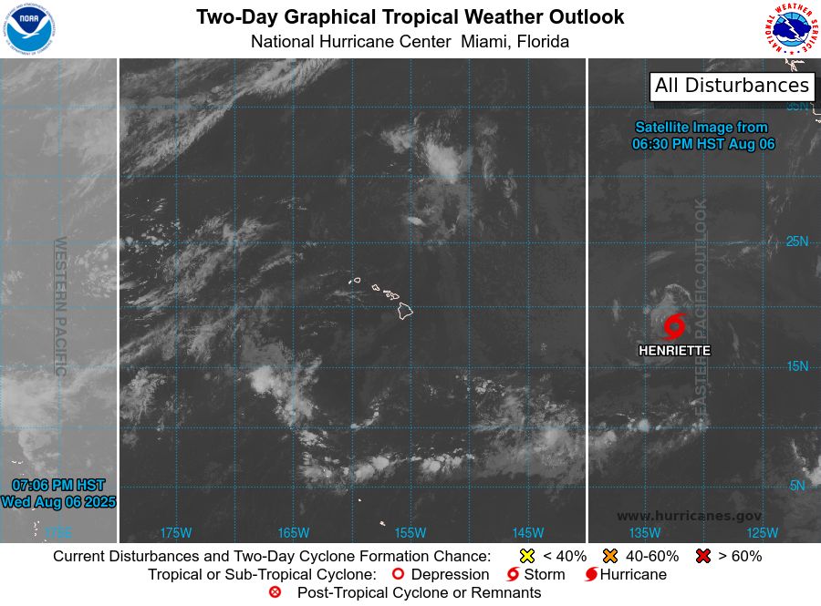
tropical weather outlook over the next 2 days greyscale satellite image of Central Pacific Ocean for
NWS Central Pacific Hurricane Center Honolulu HI
Issued by NWS National Hurricane Center Miami FL
800 PM HST Wed Aug 06 2025
For the central North Pacific...between 140W and 180W:
Active Systems:
The National Hurricane Center is issuing advisories on Tropical
Storm Henriette, located well east of the Hawaiian Islands.
Henriette is expected to move into the Central Pacific basin
Thursday night.
The National Hurricane Center is also issuing
advisories on Tropical Storm Ivo, located about 150 miles offshore
the coast of Southwestern Mexico.
Tropical cyclone formation is not expected during the next 7 days.
&&
Public Advisories on Tropical Storm Ivo are issued under WMO
header WTPZ34 KNHC and under AWIPS header MIATCPEP4.
Forecast/Advisories on Tropical Storm Ivo are issued under
WMO header WTPZ24 KNHC and under AWIPS header MIATCMEP4.
$$
Forecaster Jelsema/Bucci
NNNN

tropical weather outlook over the next 7 days color illustrated image of Central Pacific Ocean for
NWS Central Pacific Hurricane Center Honolulu HI
Issued by NWS National Hurricane Center Miami FL
800 PM HST Wed Aug 06 2025
For the central North Pacific...between 140W and 180W:
Active Systems:
The National Hurricane Center is issuing advisories on Tropical
Storm Henriette, located well east of the Hawaiian Islands.
Henriette is expected to move into the Central Pacific basin
Thursday night.
The National Hurricane Center is also issuing
advisories on Tropical Storm Ivo, located about 150 miles offshore
the coast of Southwestern Mexico.
Tropical cyclone formation is not expected during the next 7 days.
&&
Public Advisories on Tropical Storm Ivo are issued under WMO
header WTPZ34 KNHC and under AWIPS header MIATCPEP4.
Forecast/Advisories on Tropical Storm Ivo are issued under
WMO header WTPZ24 KNHC and under AWIPS header MIATCMEP4.
$$
Forecaster Jelsema/Bucci
NNNN
NWS Central Pacific Hurricane Center Honolulu HI
Issued by NWS National Hurricane Center Miami FL
800 PM HST Wed Aug 06 2025
For the central North Pacific...between 140W and 180W:
Active Systems:
The National Hurricane Center is issuing advisories on Tropical
Storm Henriette, located well east of
07.08.2025 06:14 — 👍 0 🔁 0 💬 0 📌 0
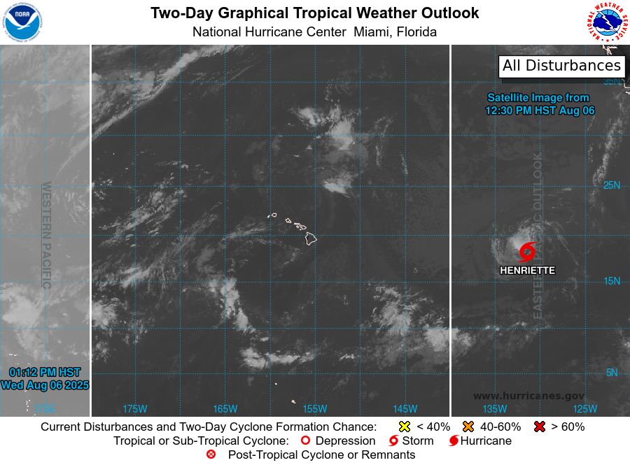
tropical weather outlook over the next 2 days greyscale satellite image of Central Pacific Ocean for
NWS Central Pacific Hurricane Center Honolulu HI
Issued by NWS National Hurricane Center Miami FL
200 PM HST Wed Aug 06 2025
For the central North Pacific...between 140W and 180W:
Active Systems:
The National Hurricane Center is issuing advisories on Tropical
Storm Henriette, located well east of the Hawaiian Islands.
Henriette is expected to move into the Central Pacific basin
Thursday night.
The National Hurricane Center is also issuing advisories on Tropical
Storm Ivo, located a couple hundred miles offshore the coast of
Southern Mexico.
Tropical cyclone formation is not expected during the next 7 days.
&&
Public Advisories on Tropical Storm Ivo are issued under WMO
header WTPZ34 KNHC and under AWIPS header MIATCPEP4.
Forecast/Advisories on Tropical Storm Ivo are issued under
WMO header WTPZ24 KNHC and under AWIPS header MIATCMEP4.
$$
Forecaster Jelsema
NNNN
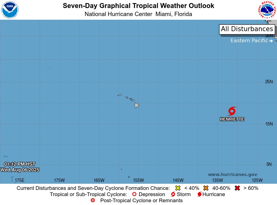
tropical weather outlook over the next 7 days color illustrated image of Central Pacific Ocean for
NWS Central Pacific Hurricane Center Honolulu HI
Issued by NWS National Hurricane Center Miami FL
200 PM HST Wed Aug 06 2025
For the central North Pacific...between 140W and 180W:
Active Systems:
The National Hurricane Center is issuing advisories on Tropical
Storm Henriette, located well east of the Hawaiian Islands.
Henriette is expected to move into the Central Pacific basin
Thursday night.
The National Hurricane Center is also issuing advisories on Tropical
Storm Ivo, located a couple hundred miles offshore the coast of
Southern Mexico.
Tropical cyclone formation is not expected during the next 7 days.
&&
Public Advisories on Tropical Storm Ivo are issued under WMO
header WTPZ34 KNHC and under AWIPS header MIATCPEP4.
Forecast/Advisories on Tropical Storm Ivo are issued under
WMO header WTPZ24 KNHC and under AWIPS header MIATCMEP4.
$$
Forecaster Jelsema
NNNN
NWS Central Pacific Hurricane Center Honolulu HI
Issued by NWS National Hurricane Center Miami FL
200 PM HST Wed Aug 06 2025
For the central North Pacific...between 140W and 180W:
Active Systems:
The National Hurricane Center is issuing advisories on Tropical
Storm Henriette, located well east of
07.08.2025 00:40 — 👍 2 🔁 1 💬 0 📌 0
tropical weather outlook over the next 2 days greyscale satellite image of Central Pacific Ocean for
NWS Central Pacific Hurricane Center Honolulu HI
Issued by NWS National Hurricane Center Miami FL
800 AM HST Wed Aug 06 2025
For the central North Pacific...between 140W and 180W:
Active Systems:
The National Hurricane Center is issuing advisories on Tropical
Storm Henriette, located well east of the Hawaiian Islands.
Henriette is expected to move into the Central Pacific basin
Thursday night.
Tropical cyclone formation is not expected during the next 7 days.
Forecaster D. Zelinsky/Santos

tropical weather outlook over the next 7 days color illustrated image of Central Pacific Ocean for
NWS Central Pacific Hurricane Center Honolulu HI
Issued by NWS National Hurricane Center Miami FL
800 AM HST Wed Aug 06 2025
For the central North Pacific...between 140W and 180W:
Active Systems:
The National Hurricane Center is issuing advisories on Tropical
Storm Henriette, located well east of the Hawaiian Islands.
Henriette is expected to move into the Central Pacific basin
Thursday night.
Tropical cyclone formation is not expected during the next 7 days.
Forecaster D. Zelinsky/Santos
NWS Central Pacific Hurricane Center Honolulu HI
Issued by NWS National Hurricane Center Miami FL
800 AM HST Wed Aug 06 2025
For the central North Pacific...between 140W and 180W:
Active Systems:
The National Hurricane Center is issuing advisories on Tropical
Storm Henriette, located well east of
06.08.2025 18:12 — 👍 1 🔁 0 💬 0 📌 0
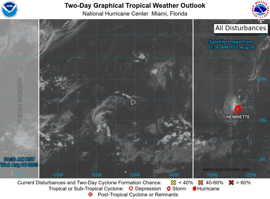
tropical weather outlook over the next 2 days greyscale satellite image of Central Pacific Ocean for
NWS Central Pacific Hurricane Center Honolulu HI
Issued by NWS National Hurricane Center Miami FL
200 AM HST Wed Aug 06 2025
For the central North Pacific...between 140W and 180W:
Active Systems:
The National Hurricane Center is issuing advisories on Tropical
Storm Henriette, located well east of the Hawaiian Islands.
Henriette is expected to move into the Central Pacific basin
Thursday night.
Tropical cyclone formation is not expected during the next 7 days.
Forecaster D. Zelinsky/Santos

tropical weather outlook over the next 7 days color illustrated image of Central Pacific Ocean for
NWS Central Pacific Hurricane Center Honolulu HI
Issued by NWS National Hurricane Center Miami FL
200 AM HST Wed Aug 06 2025
For the central North Pacific...between 140W and 180W:
Active Systems:
The National Hurricane Center is issuing advisories on Tropical
Storm Henriette, located well east of the Hawaiian Islands.
Henriette is expected to move into the Central Pacific basin
Thursday night.
Tropical cyclone formation is not expected during the next 7 days.
Forecaster D. Zelinsky/Santos
NWS Central Pacific Hurricane Center Honolulu HI
Issued by NWS National Hurricane Center Miami FL
200 AM HST Wed Aug 06 2025
For the central North Pacific...between 140W and 180W:
Active Systems:
The National Hurricane Center is issuing advisories on Tropical
Storm Henriette, located well east of
06.08.2025 12:16 — 👍 1 🔁 0 💬 0 📌 0
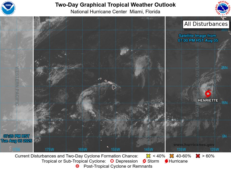
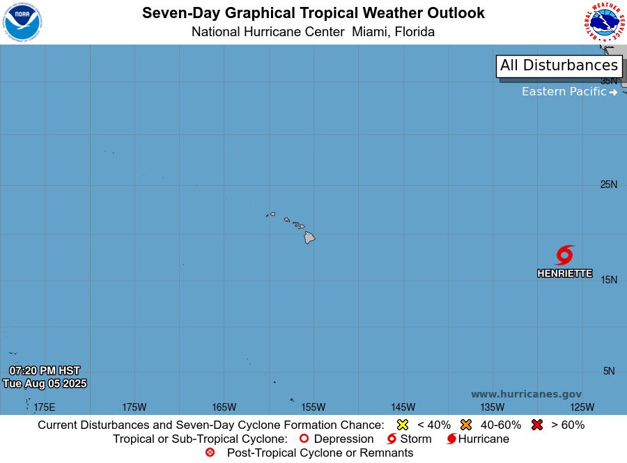
tropical weather outlook over the next 2 days greyscale satellite image of Central Pacific Ocean for
NWS Central Pacific Hurricane Center Honolulu HI
Issued by NWS National Hurricane Center Miami FL
800 PM HST Tue Aug 05 2025
For the central North Pacific...between 140W and 180W:
Active Systems:
The National Hurricane Center is issuing advisories on Tropical
Storm Henriette, located well east of the Hawaiian Islands.
Henriette is expected to move into the Central Pacific basin
Thursday night.
Tropical cyclone formation is not expected during the next 7 days.
Forecaster Jelsema
tropical weather outlook over the next 7 days color illustrated image of Central Pacific Ocean for
NWS Central Pacific Hurricane Center Honolulu HI
Issued by NWS National Hurricane Center Miami FL
800 PM HST Tue Aug 05 2025
For the central North Pacific...between 140W and 180W:
Active Systems:
The National Hurricane Center is issuing advisories on Tropical
Storm Henriette, located well east of the Hawaiian Islands.
Henriette is expected to move into the Central Pacific basin
Thursday night.
Tropical cyclone formation is not expected during the next 7 days.
Forecaster Jelsema
NWS Central Pacific Hurricane Center Honolulu HI
Issued by NWS National Hurricane Center Miami FL
800 PM HST Tue Aug 05 2025
For the central North Pacific...between 140W and 180W:
Active Systems:
The National Hurricane Center is issuing advisories on Tropical
Storm Henriette, located well east of
06.08.2025 06:14 — 👍 1 🔁 0 💬 0 📌 0
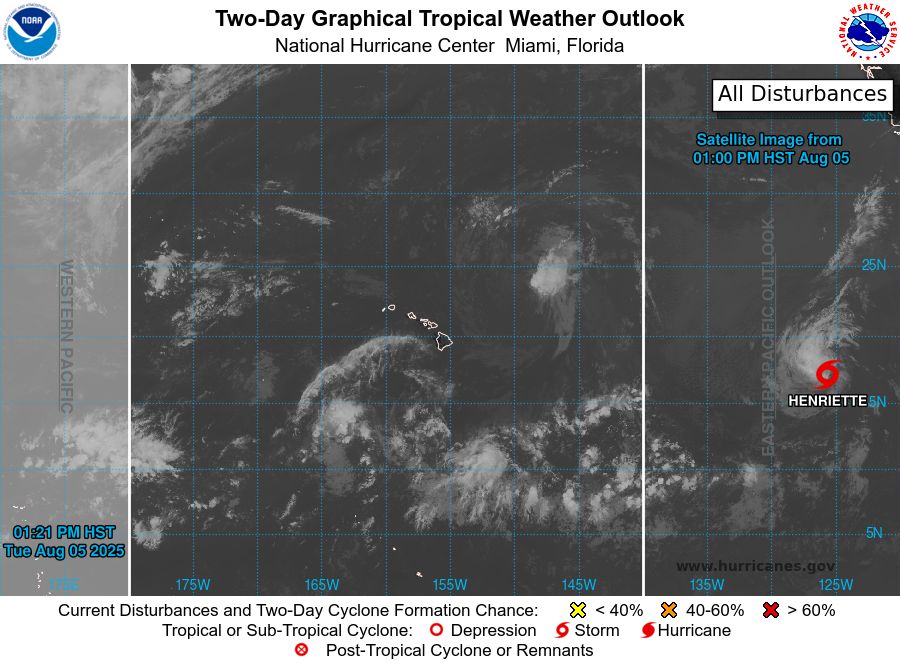
tropical weather outlook over the next 2 days greyscale satellite image of Central Pacific Ocean for
NWS Central Pacific Hurricane Center Honolulu HI
Issued by NWS National Hurricane Center Miami FL
200 PM HST Tue Aug 05 2025
For the central North Pacific...between 140W and 180W:
Active Systems:
The National Hurricane Center is issuing advisories on Tropical
Storm Henriette, located well west-southwest of the Baja California
Peninsula. Henriette is expected to move into the Central Pacific
basin Thursday night or early Friday.
Tropical cyclone formation is not expected during the next 7 days.
Forecaster Jelsema

tropical weather outlook over the next 7 days color illustrated image of Central Pacific Ocean for
NWS Central Pacific Hurricane Center Honolulu HI
Issued by NWS National Hurricane Center Miami FL
200 PM HST Tue Aug 05 2025
For the central North Pacific...between 140W and 180W:
Active Systems:
The National Hurricane Center is issuing advisories on Tropical
Storm Henriette, located well west-southwest of the Baja California
Peninsula. Henriette is expected to move into the Central Pacific
basin Thursday night or early Friday.
Tropical cyclone formation is not expected during the next 7 days.
Forecaster Jelsema
NWS Central Pacific Hurricane Center Honolulu HI
Issued by NWS National Hurricane Center Miami FL
200 PM HST Tue Aug 05 2025
For the central North Pacific...between 140W and 180W:
Active Systems:
The National Hurricane Center is issuing advisories on Tropical
Storm Henriette, located well west-sou
06.08.2025 00:40 — 👍 1 🔁 0 💬 0 📌 0
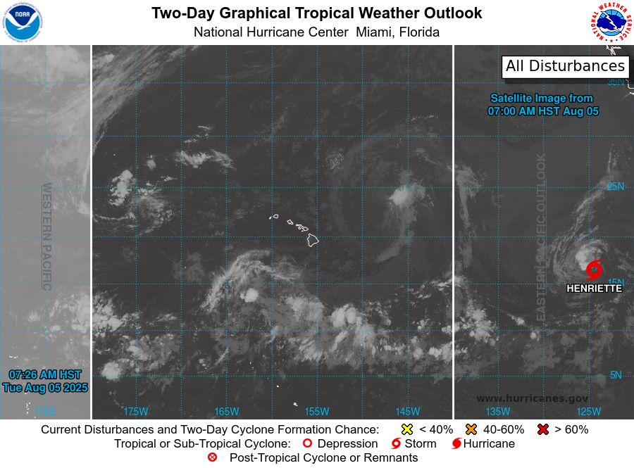
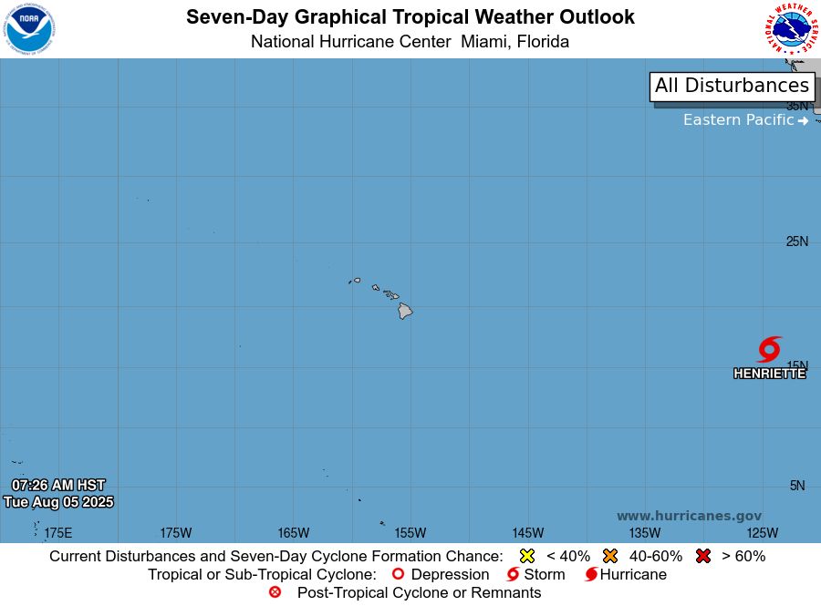
tropical weather outlook over the next 2 days greyscale satellite image of Central Pacific Ocean for
NWS Central Pacific Hurricane Center Honolulu HI
Issued by NWS National Hurricane Center Miami FL
800 AM HST Tue Aug 05 2025
For the central North Pacific...between 140W and 180W:
Active Systems:
The National Hurricane Center is issuing advisories on Tropical
Storm Henriette, located well west-southwest of the Baja California
Peninsula. Henriette is expected to move into the Central Pacific
basin Thursday night or Friday morning.
Tropical cyclone formation is not expected during the next 7 days.
Forecaster Roberts
tropical weather outlook over the next 7 days color illustrated image of Central Pacific Ocean for
NWS Central Pacific Hurricane Center Honolulu HI
Issued by NWS National Hurricane Center Miami FL
800 AM HST Tue Aug 05 2025
For the central North Pacific...between 140W and 180W:
Active Systems:
The National Hurricane Center is issuing advisories on Tropical
Storm Henriette, located well west-southwest of the Baja California
Peninsula. Henriette is expected to move into the Central Pacific
basin Thursday night or Friday morning.
Tropical cyclone formation is not expected during the next 7 days.
Forecaster Roberts
NWS Central Pacific Hurricane Center Honolulu HI
Issued by NWS National Hurricane Center Miami FL
800 AM HST Tue Aug 05 2025
For the central North Pacific...between 140W and 180W:
Active Systems:
The National Hurricane Center is issuing advisories on Tropical
Storm Henriette, located well west-sou
05.08.2025 18:12 — 👍 1 🔁 0 💬 0 📌 0
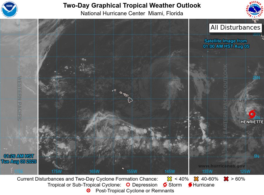
tropical weather outlook over the next 2 days greyscale satellite image of Central Pacific Ocean for
NWS Central Pacific Hurricane Center Honolulu HI
Issued by NWS National Hurricane Center Miami FL
200 AM HST Tue Aug 05 2025
For the central North Pacific...between 140W and 180W:
Active Systems:
The National Hurricane Center is issuing advisories on Tropical
Storm Henriette, located well southwest of the Baja California
Peninsula. Henriette is expected to move into the Central Pacific
basin Thursday night or Friday morning.
Tropical cyclone formation is not expected during the next 7 days.
Forecaster Roberts

tropical weather outlook over the next 7 days color illustrated image of Central Pacific Ocean for
NWS Central Pacific Hurricane Center Honolulu HI
Issued by NWS National Hurricane Center Miami FL
200 AM HST Tue Aug 05 2025
For the central North Pacific...between 140W and 180W:
Active Systems:
The National Hurricane Center is issuing advisories on Tropical
Storm Henriette, located well southwest of the Baja California
Peninsula. Henriette is expected to move into the Central Pacific
basin Thursday night or Friday morning.
Tropical cyclone formation is not expected during the next 7 days.
Forecaster Roberts
NWS Central Pacific Hurricane Center Honolulu HI
Issued by NWS National Hurricane Center Miami FL
200 AM HST Tue Aug 05 2025
For the central North Pacific...between 140W and 180W:
Active Systems:
The National Hurricane Center is issuing advisories on Tropical
Storm Henriette, located well southwes
05.08.2025 12:16 — 👍 0 🔁 0 💬 0 📌 0
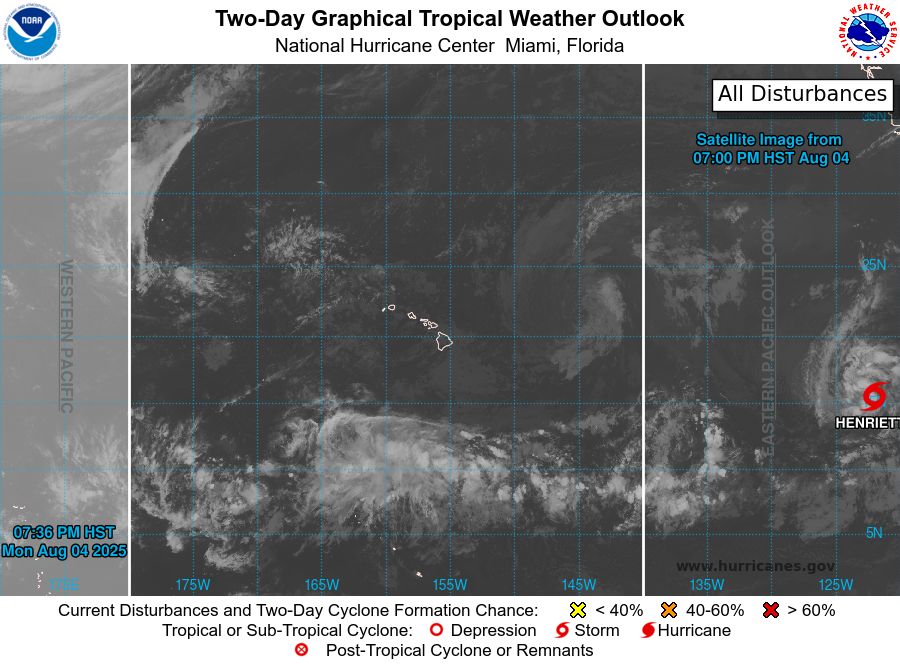
tropical weather outlook over the next 2 days greyscale satellite image of Central Pacific Ocean for
NWS Central Pacific Hurricane Center Honolulu HI
Issued by NWS National Hurricane Center Miami FL
800 PM HST Mon Aug 04 2025
For the central North Pacific...between 140W and 180W:
Active Systems:
The National Hurricane Center is issuing advisories on Tropical
Storm Henriette, located well southwest of the Baja California
Peninsula. Henriette is expected to move into the Central Pacific
basin Thursday night or Friday.
Tropical cyclone formation is not expected during the next 7 days.
Public advisories on Tropical Storm Henriette are issued under
WMO header WTPZ33 KNHC and under AWIPS header MIATCPEP3.
Forecast/Advisories on Tropical Storm Henriette are issued under
WMO header WTPZ23 KNHC and under AWIPS header MIATCMEP3.
Forecaster Jelsema

tropical weather outlook over the next 7 days color illustrated image of Central Pacific Ocean for
NWS Central Pacific Hurricane Center Honolulu HI
Issued by NWS National Hurricane Center Miami FL
800 PM HST Mon Aug 04 2025
For the central North Pacific...between 140W and 180W:
Active Systems:
The National Hurricane Center is issuing advisories on Tropical
Storm Henriette, located well southwest of the Baja California
Peninsula. Henriette is expected to move into the Central Pacific
basin Thursday night or Friday.
Tropical cyclone formation is not expected during the next 7 days.
Public advisories on Tropical Storm Henriette are issued under
WMO header WTPZ33 KNHC and under AWIPS header MIATCPEP3.
Forecast/Advisories on Tropical Storm Henriette are issued under
WMO header WTPZ23 KNHC and under AWIPS header MIATCMEP3.
Forecaster Jelsema
NWS Central Pacific Hurricane Center Honolulu HI
Issued by NWS National Hurricane Center Miami FL
800 PM HST Mon Aug 04 2025
For the central North Pacific...between 140W and 180W:
Active Systems:
The National Hurricane Center is issuing advisories on Tropical
Storm Henriette, located well southwes
05.08.2025 06:14 — 👍 2 🔁 1 💬 0 📌 0
tropical weather outlook over the next 2 days greyscale satellite image of Central Pacific Ocean for
NWS Central Pacific Hurricane Center Honolulu HI
Issued by NWS National Hurricane Center Miami FL
200 PM HST Mon Aug 04 2025
For the central North Pacific...between 140W and 180W:
Active Systems:
The National Hurricane Center is issuing advisories on Tropical
Storm Henriette, located well southwest of the Baja California
Peninsula. Henriette is expected to move into the Central Pacific
basin Thursday night or Friday.
Tropical cyclone formation is not expected during the next 7 days.
Public advisories on Tropical Storm Henriette are issued under
WMO header WTPZ33 KNHC and under AWIPS header MIATCPEP3.
Forecast/Advisories on Tropical Storm Henriette are issued under
WMO header WTPZ23 KNHC and under AWIPS header MIATCMEP3.
Forecaster Jelsema

tropical weather outlook over the next 7 days color illustrated image of Central Pacific Ocean for
NWS Central Pacific Hurricane Center Honolulu HI
Issued by NWS National Hurricane Center Miami FL
200 PM HST Mon Aug 04 2025
For the central North Pacific...between 140W and 180W:
Active Systems:
The National Hurricane Center is issuing advisories on Tropical
Storm Henriette, located well southwest of the Baja California
Peninsula. Henriette is expected to move into the Central Pacific
basin Thursday night or Friday.
Tropical cyclone formation is not expected during the next 7 days.
Public advisories on Tropical Storm Henriette are issued under
WMO header WTPZ33 KNHC and under AWIPS header MIATCPEP3.
Forecast/Advisories on Tropical Storm Henriette are issued under
WMO header WTPZ23 KNHC and under AWIPS header MIATCMEP3.
Forecaster Jelsema
NWS Central Pacific Hurricane Center Honolulu HI
Issued by NWS National Hurricane Center Miami FL
200 PM HST Mon Aug 04 2025
For the central North Pacific...between 140W and 180W:
Active Systems:
The National Hurricane Center is issuing advisories on Tropical
Storm Henriette, located well southwes
05.08.2025 00:40 — 👍 1 🔁 0 💬 0 📌 0
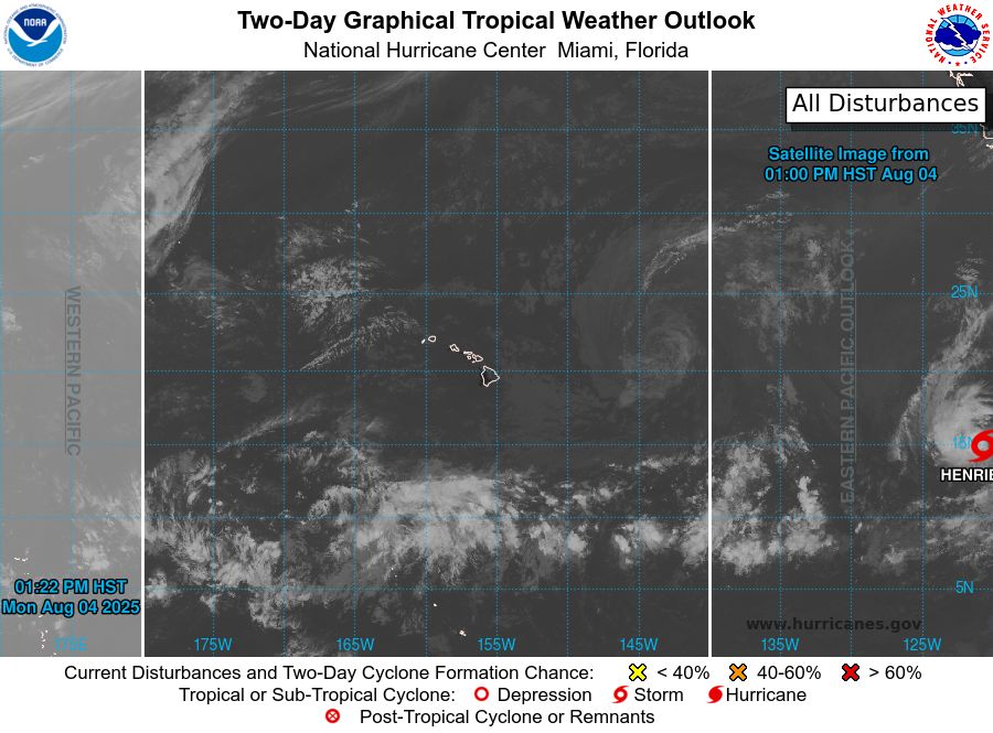
tropical weather outlook over the next 2 days greyscale satellite image of Central Pacific Ocean for
NWS Central Pacific Hurricane Center Honolulu HI
Issued by NWS National Hurricane Center Miami FL
800 AM HST Mon Aug 04 2025
For the central North Pacific...between 140W and 180W:
Active Systems:
The National Hurricane Center is issuing advisories on Tropical
Depression Eight-E, located well southwest of the Baja California
Peninsula.
Tropical cyclone formation is not expected during the next 7 days.
Public advisories on Tropical Depression Eight-E are issued under
WMO header WTPZ33 KNHC and under AWIPS header MIATCPEP3.
Forecast/Advisories on Tropical Depression Eight-E are issued under
WMO header WTPZ23 KNHC and under AWIPS header MIATCMEP3.
Forecaster Roberts

tropical weather outlook over the next 7 days color illustrated image of Central Pacific Ocean for
NWS Central Pacific Hurricane Center Honolulu HI
Issued by NWS National Hurricane Center Miami FL
800 AM HST Mon Aug 04 2025
For the central North Pacific...between 140W and 180W:
Active Systems:
The National Hurricane Center is issuing advisories on Tropical
Depression Eight-E, located well southwest of the Baja California
Peninsula.
Tropical cyclone formation is not expected during the next 7 days.
Public advisories on Tropical Depression Eight-E are issued under
WMO header WTPZ33 KNHC and under AWIPS header MIATCPEP3.
Forecast/Advisories on Tropical Depression Eight-E are issued under
WMO header WTPZ23 KNHC and under AWIPS header MIATCMEP3.
Forecaster Roberts
NWS Central Pacific Hurricane Center Honolulu HI
Issued by NWS National Hurricane Center Miami FL
800 AM HST Mon Aug 04 2025
For the central North Pacific...between 140W and 180W:
Active Systems:
The National Hurricane Center is issuing advisories on Tropical
Depression Eight-E, located well south
04.08.2025 18:12 — 👍 1 🔁 0 💬 0 📌 0
tropical weather outlook over the next 2 days greyscale satellite image of Central Pacific Ocean for
NWS Central Pacific Hurricane Center Honolulu HI
Issued by NWS National Hurricane Center Miami FL
200 AM HST Mon Aug 04 2025
For the central North Pacific...between 140W and 180W:
Active Systems:
The National Hurricane Center is issuing advisories on newly formed
Tropical Depression Eight-E, located well southwest of the Baja
California Peninsula.
Tropical cyclone formation is not expected during the next 7 days.
Public advisories on Tropical Depression Eight-E are issued under
WMO header WTPZ33 KNHC and under AWIPS header MIATCPEP3.
Forecast/Advisories on Tropical Depression Eight-E are issued under
WMO header WTPZ23 KNHC and under AWIPS header MIATCMEP3.
Forecaster Gibbs

tropical weather outlook over the next 7 days color illustrated image of Central Pacific Ocean for
NWS Central Pacific Hurricane Center Honolulu HI
Issued by NWS National Hurricane Center Miami FL
200 AM HST Mon Aug 04 2025
For the central North Pacific...between 140W and 180W:
Active Systems:
The National Hurricane Center is issuing advisories on newly formed
Tropical Depression Eight-E, located well southwest of the Baja
California Peninsula.
Tropical cyclone formation is not expected during the next 7 days.
Public advisories on Tropical Depression Eight-E are issued under
WMO header WTPZ33 KNHC and under AWIPS header MIATCPEP3.
Forecast/Advisories on Tropical Depression Eight-E are issued under
WMO header WTPZ23 KNHC and under AWIPS header MIATCMEP3.
Forecaster Gibbs
NWS Central Pacific Hurricane Center Honolulu HI
Issued by NWS National Hurricane Center Miami FL
200 AM HST Mon Aug 04 2025
For the central North Pacific...between 140W and 180W:
Active Systems:
The National Hurricane Center is issuing advisories on newly formed
Tropical Depression Eight-E, locat
04.08.2025 12:15 — 👍 0 🔁 0 💬 0 📌 0
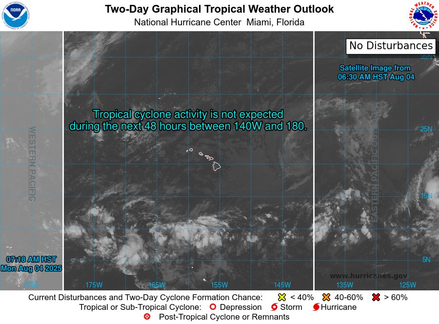
tropical weather outlook over the next 2 days greyscale satellite image of Central Pacific Ocean for
NWS Central Pacific Hurricane Center Honolulu HI
Issued by NWS National Hurricane Center Miami FL
800 PM HST Sun Aug 03 2025
For the central North Pacific...between 140W and 180W:
Tropical cyclone formation is not expected during the next 7 days.
Forecaster Gibbs

tropical weather outlook over the next 7 days color illustrated image of Central Pacific Ocean for
NWS Central Pacific Hurricane Center Honolulu HI
Issued by NWS National Hurricane Center Miami FL
800 PM HST Sun Aug 03 2025
For the central North Pacific...between 140W and 180W:
Tropical cyclone formation is not expected during the next 7 days.
Forecaster Gibbs
NWS Central Pacific Hurricane Center Honolulu HI
Issued by NWS National Hurricane Center Miami FL
800 PM HST Sun Aug 03 2025
For the central North Pacific...between 140W and 180W:
Tropical cyclone formation is not expected during the next 7 days.
Forecaster Gibbs
04.08.2025 06:17 — 👍 2 🔁 0 💬 0 📌 0
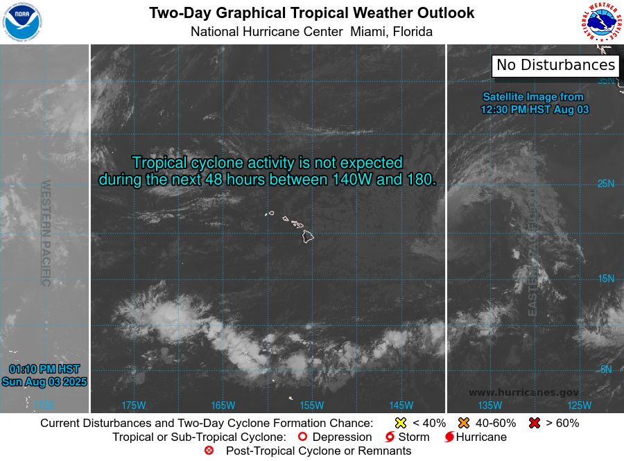
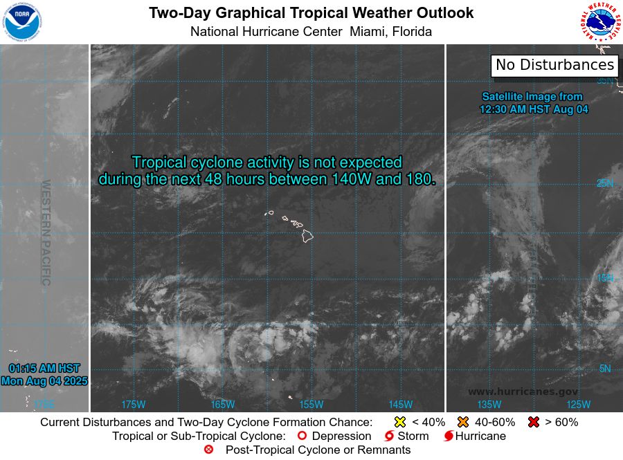
tropical weather outlook over the next 2 days greyscale satellite image of Central Pacific Ocean for
NWS Central Pacific Hurricane Center Honolulu HI
Issued by NWS National Hurricane Center Miami FL
200 PM HST Sun Aug 03 2025
For the central North Pacific...between 140W and 180W:
Tropical cyclone formation is not expected during the next 7 days.
Forecaster Pasch
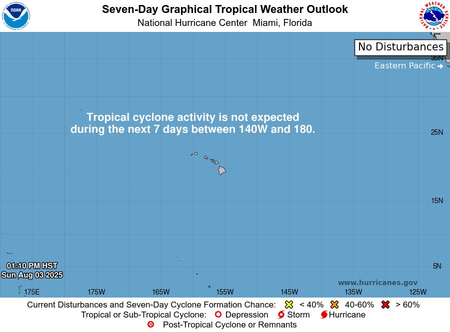
tropical weather outlook over the next 7 days color illustrated image of Central Pacific Ocean for
NWS Central Pacific Hurricane Center Honolulu HI
Issued by NWS National Hurricane Center Miami FL
200 PM HST Sun Aug 03 2025
For the central North Pacific...between 140W and 180W:
Tropical cyclone formation is not expected during the next 7 days.
Forecaster Pasch
NWS Central Pacific Hurricane Center Honolulu HI
Issued by NWS National Hurricane Center Miami FL
200 PM HST Sun Aug 03 2025
For the central North Pacific...between 140W and 180W:
Tropical cyclone formation is not expected during the next 7 days.
Forecaster Pasch
04.08.2025 00:43 — 👍 1 🔁 0 💬 0 📌 0
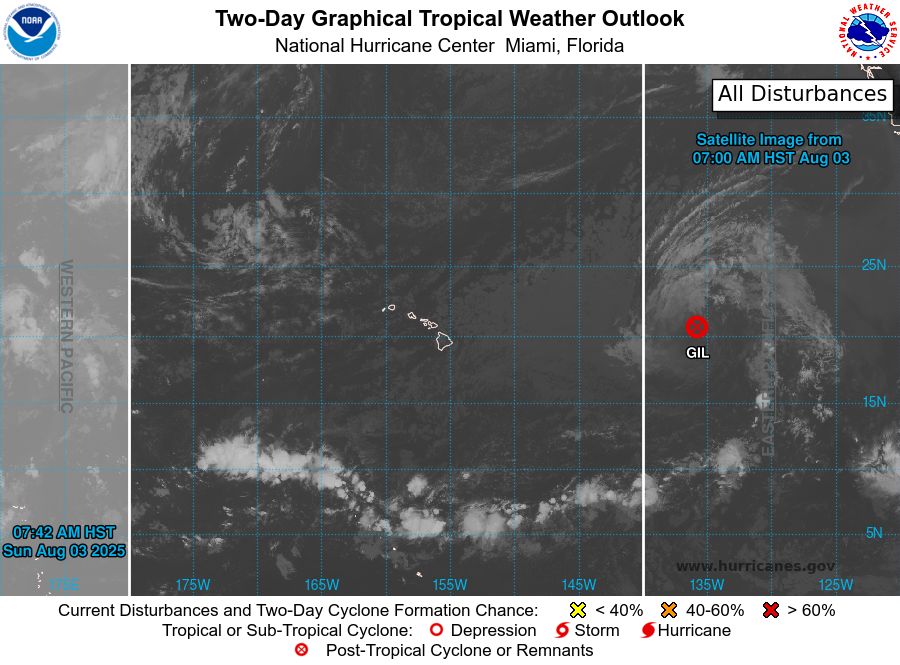
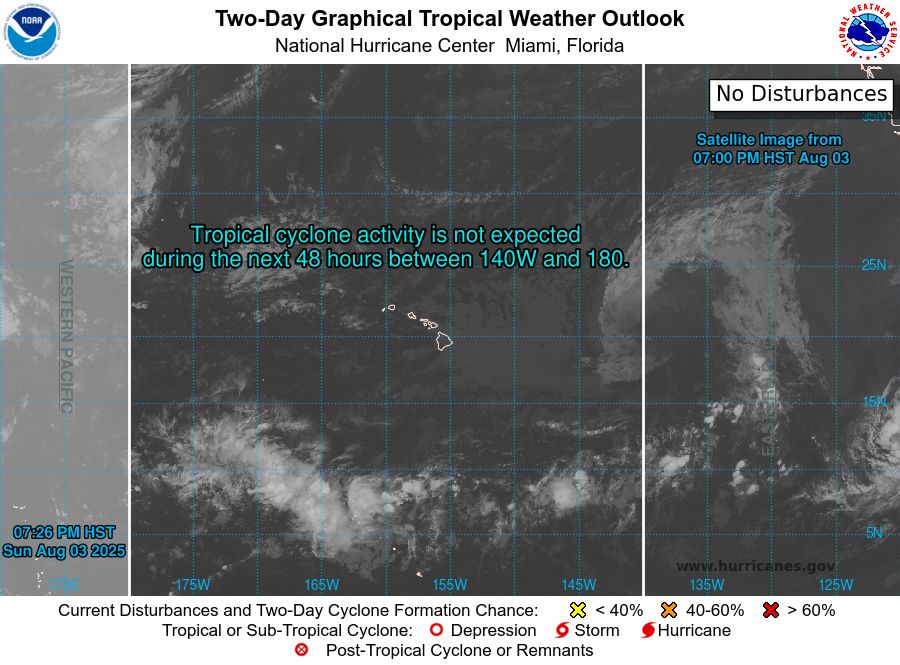
tropical weather outlook over the next 2 days greyscale satellite image of Central Pacific Ocean for
NWS Central Pacific Hurricane Center Honolulu HI
Issued by NWS National Hurricane Center Miami FL
800 AM HST Sun Aug 03 2025
For the central North Pacific...between 140W and 180W:
Active Systems:
The National Hurricane Center has issued the last advisory on
Post-Tropical Cyclone Gil, located well east of the Hawaiian
Islands.
Tropical cyclone formation is not expected during the next 7 days.
Forecaster Bucci/Rosado-Vazquez
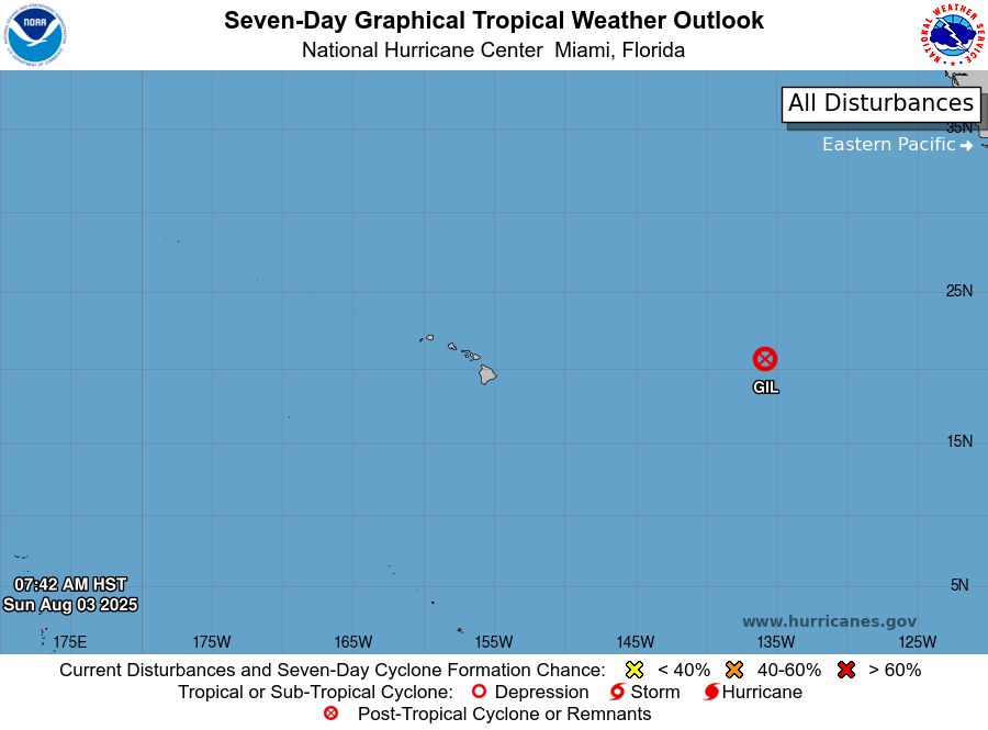
tropical weather outlook over the next 7 days color illustrated image of Central Pacific Ocean for
NWS Central Pacific Hurricane Center Honolulu HI
Issued by NWS National Hurricane Center Miami FL
800 AM HST Sun Aug 03 2025
For the central North Pacific...between 140W and 180W:
Active Systems:
The National Hurricane Center has issued the last advisory on
Post-Tropical Cyclone Gil, located well east of the Hawaiian
Islands.
Tropical cyclone formation is not expected during the next 7 days.
Forecaster Bucci/Rosado-Vazquez
NWS Central Pacific Hurricane Center Honolulu HI
Issued by NWS National Hurricane Center Miami FL
800 AM HST Sun Aug 03 2025
For the central North Pacific...between 140W and 180W:
Active Systems:
The National Hurricane Center has issued the last advisory on
Post-Tropical Cyclone Gil, located well
03.08.2025 18:10 — 👍 2 🔁 0 💬 0 📌 0
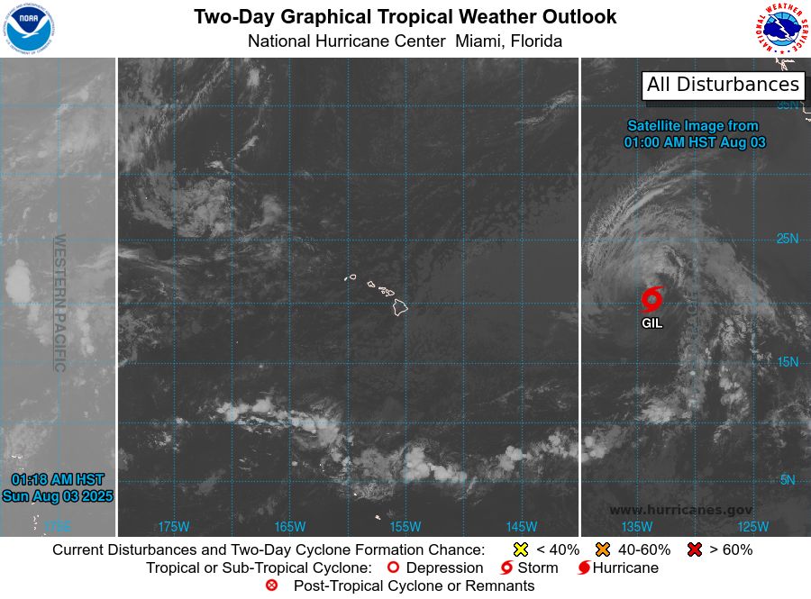
tropical weather outlook over the next 2 days greyscale satellite image of Central Pacific Ocean for
NWS Central Pacific Hurricane Center Honolulu HI
Issued by NWS National Hurricane Center Miami FL
200 AM HST Sun Aug 03 2025
For the central North Pacific...between 140W and 180W:
Active Systems:
The National Hurricane Center is issuing advisories on Tropical
Storm Gil, located well east of the Hawaiian Islands.
Tropical cyclone formation is not expected during the next 7 days.
Forecaster Gibbs
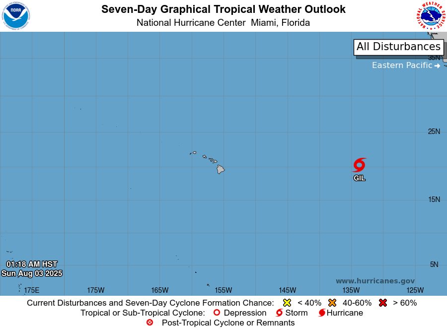
tropical weather outlook over the next 7 days color illustrated image of Central Pacific Ocean for
NWS Central Pacific Hurricane Center Honolulu HI
Issued by NWS National Hurricane Center Miami FL
200 AM HST Sun Aug 03 2025
For the central North Pacific...between 140W and 180W:
Active Systems:
The National Hurricane Center is issuing advisories on Tropical
Storm Gil, located well east of the Hawaiian Islands.
Tropical cyclone formation is not expected during the next 7 days.
Forecaster Gibbs
NWS Central Pacific Hurricane Center Honolulu HI
Issued by NWS National Hurricane Center Miami FL
200 AM HST Sun Aug 03 2025
For the central North Pacific...between 140W and 180W:
Active Systems:
The National Hurricane Center is issuing advisories on Tropical
Storm Gil, located well east of the Ha
03.08.2025 12:13 — 👍 1 🔁 1 💬 0 📌 0
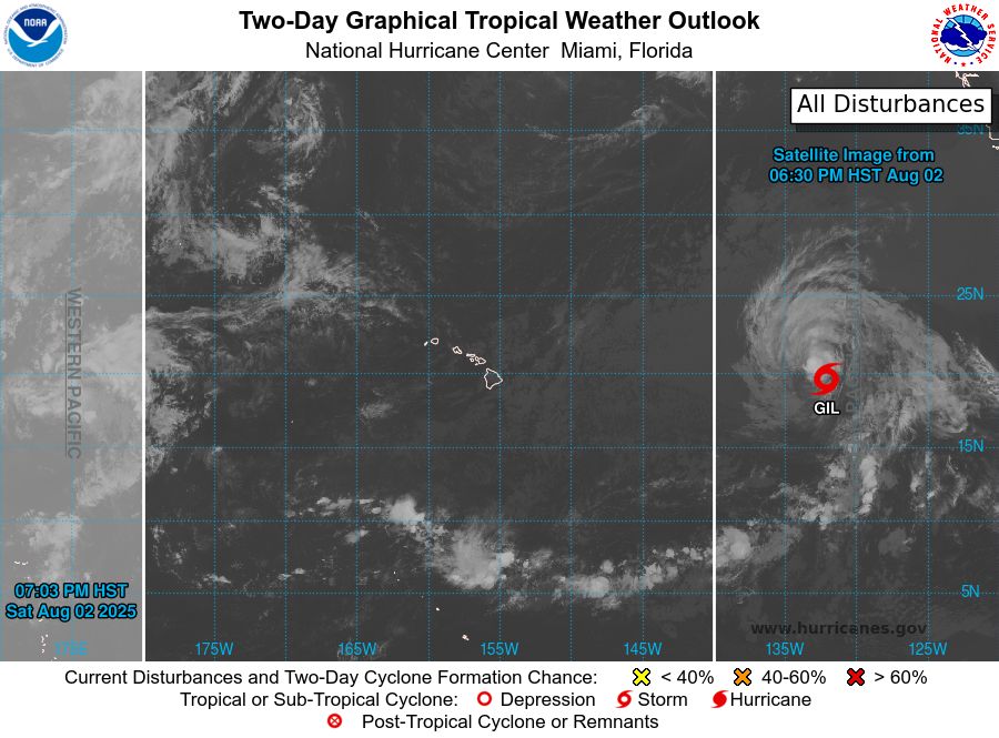
tropical weather outlook over the next 2 days greyscale satellite image of Central Pacific Ocean for
NWS Central Pacific Hurricane Center Honolulu HI
Issued by NWS National Hurricane Center Miami FL
800 PM HST Sat Aug 02 2025
For the central North Pacific...between 140W and 180W:
Active Systems:
The National Hurricane Center is issuing advisories on Tropical
Storm Gil, located well east of the Hawaiian Islands.
Tropical cyclone formation is not expected during the next 7 days.
Forecaster Gibbs
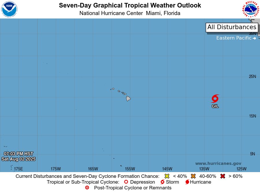
tropical weather outlook over the next 7 days color illustrated image of Central Pacific Ocean for
NWS Central Pacific Hurricane Center Honolulu HI
Issued by NWS National Hurricane Center Miami FL
800 PM HST Sat Aug 02 2025
For the central North Pacific...between 140W and 180W:
Active Systems:
The National Hurricane Center is issuing advisories on Tropical
Storm Gil, located well east of the Hawaiian Islands.
Tropical cyclone formation is not expected during the next 7 days.
Forecaster Gibbs
NWS Central Pacific Hurricane Center Honolulu HI
Issued by NWS National Hurricane Center Miami FL
800 PM HST Sat Aug 02 2025
For the central North Pacific...between 140W and 180W:
Active Systems:
The National Hurricane Center is issuing advisories on Tropical
Storm Gil, located well east of the Ha
03.08.2025 06:12 — 👍 1 🔁 0 💬 0 📌 0
tropical weather outlook over the next 2 days greyscale satellite image of Central Pacific Ocean for
NWS Central Pacific Hurricane Center Honolulu HI
Issued by NWS National Hurricane Center Miami FL
200 PM HST Sat Aug 02 2025
For the central North Pacific...between 140W and 180W:
Active Systems:
The National Hurricane Center is issuing advisories on Tropical
Storm Gil, located well west of the southern tip of the Baja
California peninsula.
Tropical cyclone formation is not expected during the next 7 days.
Forecaster Berg

tropical weather outlook over the next 7 days color illustrated image of Central Pacific Ocean for
NWS Central Pacific Hurricane Center Honolulu HI
Issued by NWS National Hurricane Center Miami FL
200 PM HST Sat Aug 02 2025
For the central North Pacific...between 140W and 180W:
Active Systems:
The National Hurricane Center is issuing advisories on Tropical
Storm Gil, located well west of the southern tip of the Baja
California peninsula.
Tropical cyclone formation is not expected during the next 7 days.
Forecaster Berg
NWS Central Pacific Hurricane Center Honolulu HI
Issued by NWS National Hurricane Center Miami FL
200 PM HST Sat Aug 02 2025
For the central North Pacific...between 140W and 180W:
Active Systems:
The National Hurricane Center is issuing advisories on Tropical
Storm Gil, located well west of the so
03.08.2025 00:44 — 👍 1 🔁 0 💬 0 📌 0
tropical weather outlook over the next 2 days greyscale satellite image of Central Pacific Ocean for
NWS Central Pacific Hurricane Center Honolulu HI
Issued by NWS National Hurricane Center Miami FL
800 AM HST Sat Aug 02 2025
For the central North Pacific...between 140W and 180W:
Active Systems:
The National Hurricane Center is issuing advisories on
recently-downgraded Tropical Storm Gil, located well
west-southwest of the southern Baja California peninsula.
Tropical cyclone formation is not expected during the next 7 days.
Forecaster Hogsett
tropical weather outlook over the next 7 days color illustrated image of Central Pacific Ocean for
NWS Central Pacific Hurricane Center Honolulu HI
Issued by NWS National Hurricane Center Miami FL
800 AM HST Sat Aug 02 2025
For the central North Pacific...between 140W and 180W:
Active Systems:
The National Hurricane Center is issuing advisories on
recently-downgraded Tropical Storm Gil, located well
west-southwest of the southern Baja California peninsula.
Tropical cyclone formation is not expected during the next 7 days.
Forecaster Hogsett
NWS Central Pacific Hurricane Center Honolulu HI
Issued by NWS National Hurricane Center Miami FL
800 AM HST Sat Aug 02 2025
For the central North Pacific...between 140W and 180W:
Active Systems:
The National Hurricane Center is issuing advisories on
recently-downgraded Tropical Storm Gil, located
02.08.2025 18:10 — 👍 2 🔁 0 💬 0 📌 0
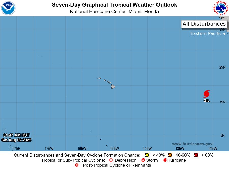
tropical weather outlook over the next 2 days greyscale satellite image of Central Pacific Ocean for
NWS Central Pacific Hurricane Center Honolulu HI
Issued by NWS National Hurricane Center Miami FL
200 AM HST Sat Aug 02 2025
For the central North Pacific...between 140W and 180W:
Active Systems:
The National Hurricane Center is issuing advisories on Hurricane
Gil, located well west-southwest of the southern Baja California
peninsula.
Tropical cyclone formation is not expected during the next 7 days.
Forecaster Hogsett
tropical weather outlook over the next 7 days color illustrated image of Central Pacific Ocean for
NWS Central Pacific Hurricane Center Honolulu HI
Issued by NWS National Hurricane Center Miami FL
200 AM HST Sat Aug 02 2025
For the central North Pacific...between 140W and 180W:
Active Systems:
The National Hurricane Center is issuing advisories on Hurricane
Gil, located well west-southwest of the southern Baja California
peninsula.
Tropical cyclone formation is not expected during the next 7 days.
Forecaster Hogsett
NWS Central Pacific Hurricane Center Honolulu HI
Issued by NWS National Hurricane Center Miami FL
200 AM HST Sat Aug 02 2025
For the central North Pacific...between 140W and 180W:
Active Systems:
The National Hurricane Center is issuing advisories on Hurricane
Gil, located well west-southwest of t
02.08.2025 12:13 — 👍 1 🔁 0 💬 0 📌 0
tropical weather outlook over the next 2 days greyscale satellite image of Central Pacific Ocean for
NWS Central Pacific Hurricane Center Honolulu HI
Issued by NWS National Hurricane Center Miami FL
800 PM HST Fri Aug 01 2025
For the central North Pacific...between 140W and 180W:
Active Systems:
The National Hurricane Center is issuing advisories on Hurricane
Gil, located well west-southwest of the southern Baja California
peninsula. The Central Pacific Hurricane Center has issued its final
advisory on Tropical Depression Iona, which is now located west of
the International Date Line, well west-southwest of the Hawaiian
Islands. Future advisories will be issued by RSMC Tokyo, Japan. For
U.S. interests, refer to Department of Defense warnings issued by
the Joint Typhoon Warning Center in Honolulu, Hawaii.
1. Western East Pacific:
An area of low pressure is expected to form well southwest of
southwestern Mexico within the next day or two. Environmental
conditions appear conducive for some gradual development of this
system, and a tropical depression is likely to form late this
weekend or early next week as the system moves west-northwestward at
10 to 15 mph.
* Formation chance through 48 hours...medium...50 percent.
* Formation chance through 7 days...high...80 percent.
Forecaster Gibbs
tropical weather outlook over the next 7 days color illustrated image of Central Pacific Ocean for
NWS Central Pacific Hurricane Center Honolulu HI
Issued by NWS National Hurricane Center Miami FL
800 PM HST Fri Aug 01 2025
For the central North Pacific...between 140W and 180W:
Active Systems:
The National Hurricane Center is issuing advisories on Hurricane
Gil, located well west-southwest of the southern Baja California
peninsula. The Central Pacific Hurricane Center has issued its final
advisory on Tropical Depression Iona, which is now located west of
the International Date Line, well west-southwest of the Hawaiian
Islands. Future advisories will be issued by RSMC Tokyo, Japan. For
U.S. interests, refer to Department of Defense warnings issued by
the Joint Typhoon Warning Center in Honolulu, Hawaii.
1. Western East Pacific:
An area of low pressure is expected to form well southwest of
southwestern Mexico within the next day or two. Environmental
conditions appear conducive for some gradual development of this
system, and a tropical depression is likely to form late this
weekend or early next week as the system moves west-northwestward at
10 to 15 mph.
* Formation chance through 48 hours...medium...50 percent.
* Formation chance through 7 days...high...80 percent.
Forecaster Gibbs
NWS Central Pacific Hurricane Center Honolulu HI
Issued by NWS National Hurricane Center Miami FL
800 PM HST Fri Aug 01 2025
For the central North Pacific...between 140W and 180W:
Active Systems:
The National Hurricane Center is issuing advisories on Hurricane
Gil, located well west-southwest of t
02.08.2025 06:11 — 👍 0 🔁 0 💬 0 📌 0
tropical weather outlook over the next 2 days greyscale satellite image of Central Pacific Ocean for
NWS Central Pacific Hurricane Center Honolulu HI
Issued by NWS National Hurricane Center Miami FL
200 PM HST Fri Aug 01 2025
For the central North Pacific...between 140W and 180W:
Active Systems:
The National Hurricane Center is issuing advisories on Tropical
Storm Iona, located in the central Pacific basin well west-southwest
of the Hawaiian Islands, and Tropical Storm Gil, located well
west-southwest of the southern Baja California peninsula.
Tropical cyclone formation is not expected during the next 7 days.
Forecaster Gibbs
tropical weather outlook over the next 7 days color illustrated image of Central Pacific Ocean for
NWS Central Pacific Hurricane Center Honolulu HI
Issued by NWS National Hurricane Center Miami FL
200 PM HST Fri Aug 01 2025
For the central North Pacific...between 140W and 180W:
Active Systems:
The National Hurricane Center is issuing advisories on Tropical
Storm Iona, located in the central Pacific basin well west-southwest
of the Hawaiian Islands, and Tropical Storm Gil, located well
west-southwest of the southern Baja California peninsula.
Tropical cyclone formation is not expected during the next 7 days.
Forecaster Gibbs
NWS Central Pacific Hurricane Center Honolulu HI
Issued by NWS National Hurricane Center Miami FL
200 PM HST Fri Aug 01 2025
For the central North Pacific...between 140W and 180W:
Active Systems:
The National Hurricane Center is issuing advisories on Tropical
Storm Iona, located in the central Pac
02.08.2025 00:37 — 👍 1 🔁 0 💬 0 📌 0
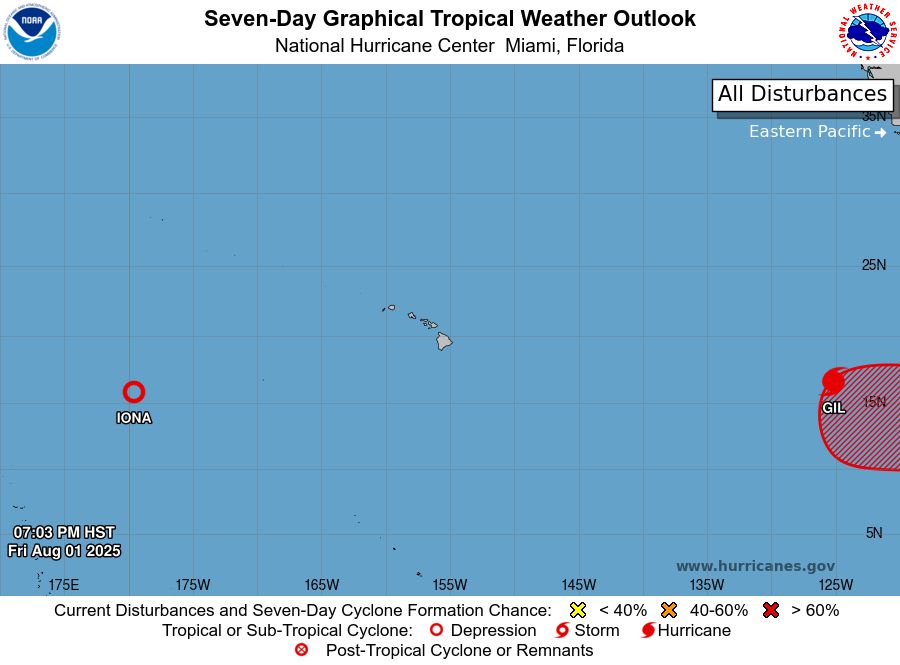
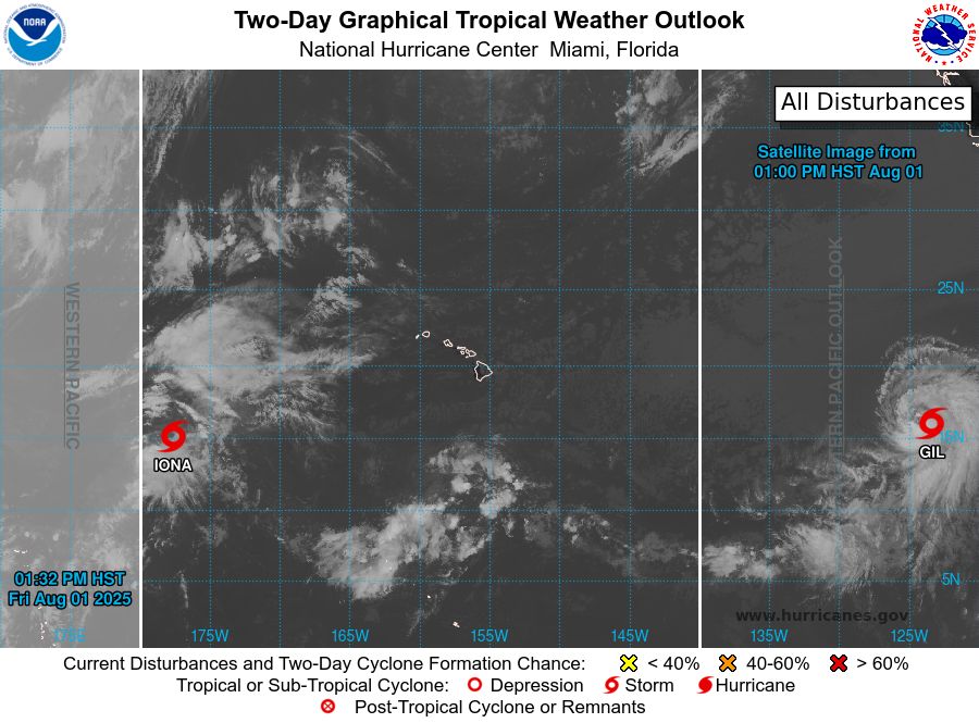
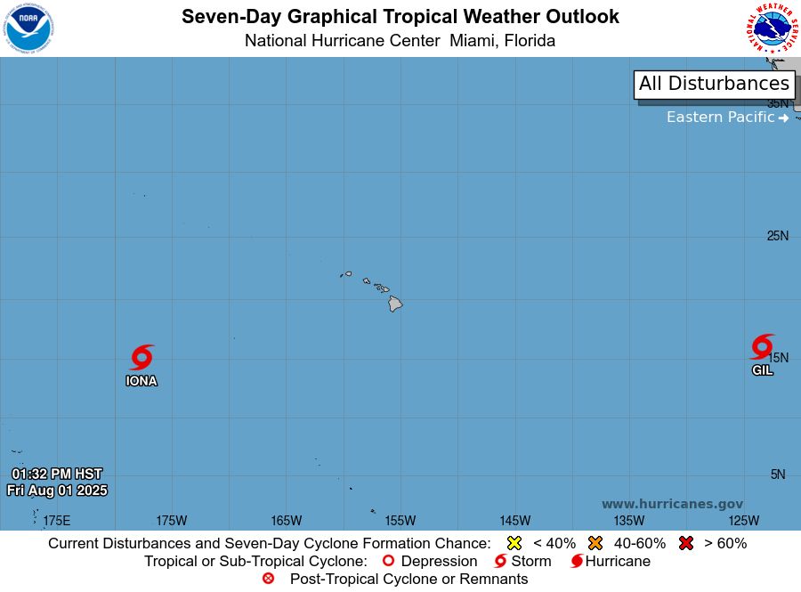
tropical weather outlook over the next 2 days greyscale satellite image of Central Pacific Ocean for
NWS Central Pacific Hurricane Center Honolulu HI
Issued by NWS National Hurricane Center Miami FL
800 AM HST Fri Aug 01 2025
For the central North Pacific...between 140W and 180W:
Active Systems:
The National Hurricane Center is issuing advisories on Tropical
Storm Iona, located in the central Pacific basin well west-southwest
of the Hawaiian Islands and Tropical Storm Gil, located well
west-southwest of the southern Baja California peninsula.
Tropical cyclone formation is not expected during the next 7 days.
Forecaster Bucci

tropical weather outlook over the next 7 days color illustrated image of Central Pacific Ocean for
NWS Central Pacific Hurricane Center Honolulu HI
Issued by NWS National Hurricane Center Miami FL
800 AM HST Fri Aug 01 2025
For the central North Pacific...between 140W and 180W:
Active Systems:
The National Hurricane Center is issuing advisories on Tropical
Storm Iona, located in the central Pacific basin well west-southwest
of the Hawaiian Islands and Tropical Storm Gil, located well
west-southwest of the southern Baja California peninsula.
Tropical cyclone formation is not expected during the next 7 days.
Forecaster Bucci
NWS Central Pacific Hurricane Center Honolulu HI
Issued by NWS National Hurricane Center Miami FL
800 AM HST Fri Aug 01 2025
For the central North Pacific...between 140W and 180W:
Active Systems:
The National Hurricane Center is issuing advisories on Tropical
Storm Iona, located in the central Pac
01.08.2025 18:11 — 👍 1 🔁 0 💬 0 📌 0
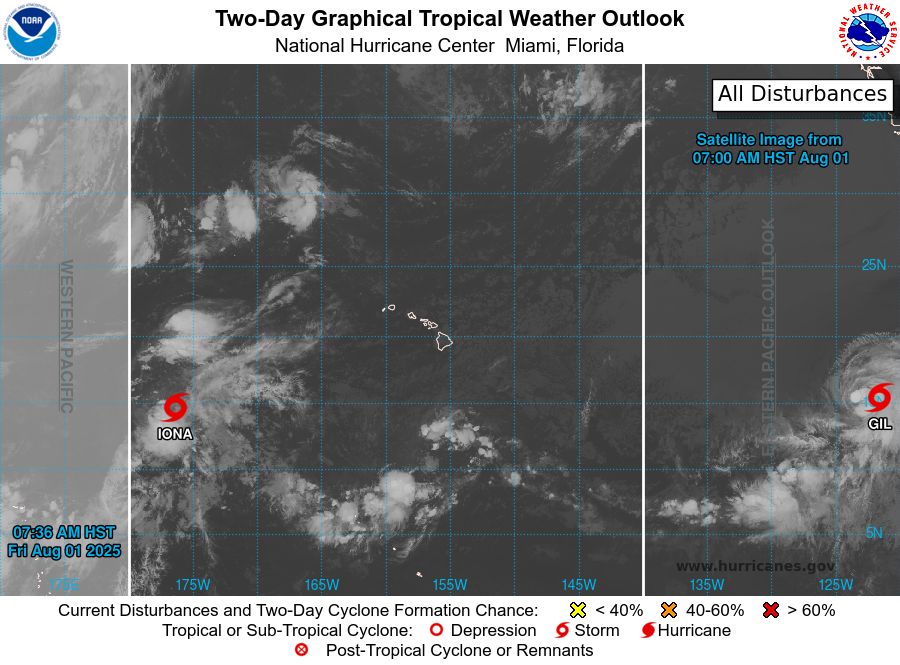
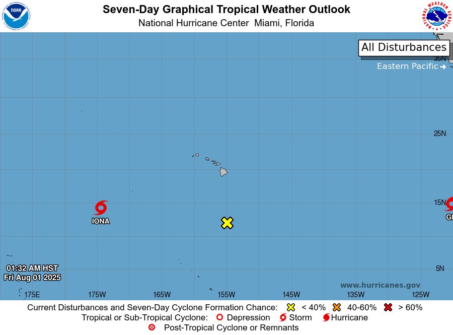
tropical weather outlook over the next 2 days greyscale satellite image of Central Pacific Ocean for
NWS Central Pacific Hurricane Center Honolulu HI
Issued by NWS National Hurricane Center Miami FL
200 AM HST Fri Aug 01 2025
For the central North Pacific...between 140W and 180W:
Active Systems:
The National Hurricane Center is issuing advisories on Tropical
Storm Iona, located in the central Pacific basin well west-southwest
of the Hawaiian Islands and Tropical Storm Gil, located well
southwest of the southern Baja California peninsula.
1. Well South-Southeast of the Hawaiian Islands (CP92):
Disorganized showers and thunderstorms are associated with a trough
of low pressure located well south-southeast of Hilo, Hawaii.
Environmental conditions are becoming increasingly unfavorable, and
development is no longer anticipated.
* Formation chance through 48 hours...low...near 0 percent.
* Formation chance through 7 days...low...near 0 percent.
Forecaster Bucci
tropical weather outlook over the next 7 days color illustrated image of Central Pacific Ocean for
NWS Central Pacific Hurricane Center Honolulu HI
Issued by NWS National Hurricane Center Miami FL
200 AM HST Fri Aug 01 2025
For the central North Pacific...between 140W and 180W:
Active Systems:
The National Hurricane Center is issuing advisories on Tropical
Storm Iona, located in the central Pacific basin well west-southwest
of the Hawaiian Islands and Tropical Storm Gil, located well
southwest of the southern Baja California peninsula.
1. Well South-Southeast of the Hawaiian Islands (CP92):
Disorganized showers and thunderstorms are associated with a trough
of low pressure located well south-southeast of Hilo, Hawaii.
Environmental conditions are becoming increasingly unfavorable, and
development is no longer anticipated.
* Formation chance through 48 hours...low...near 0 percent.
* Formation chance through 7 days...low...near 0 percent.
Forecaster Bucci
NWS Central Pacific Hurricane Center Honolulu HI
Issued by NWS National Hurricane Center Miami FL
200 AM HST Fri Aug 01 2025
For the central North Pacific...between 140W and 180W:
Active Systems:
The National Hurricane Center is issuing advisories on Tropical
Storm Iona, located in the central Pac
01.08.2025 12:15 — 👍 1 🔁 0 💬 0 📌 0
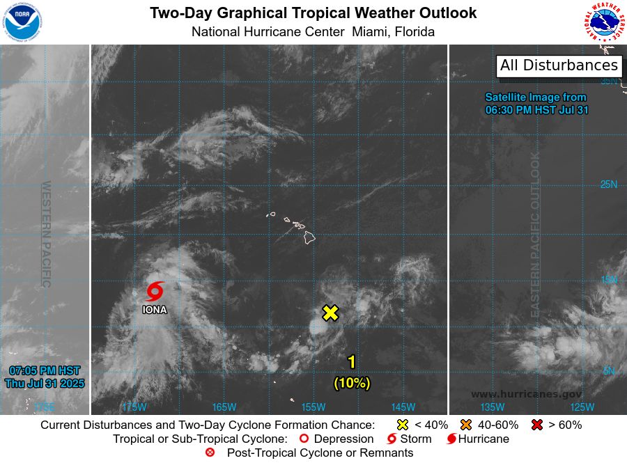
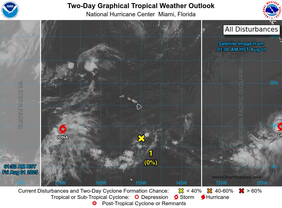
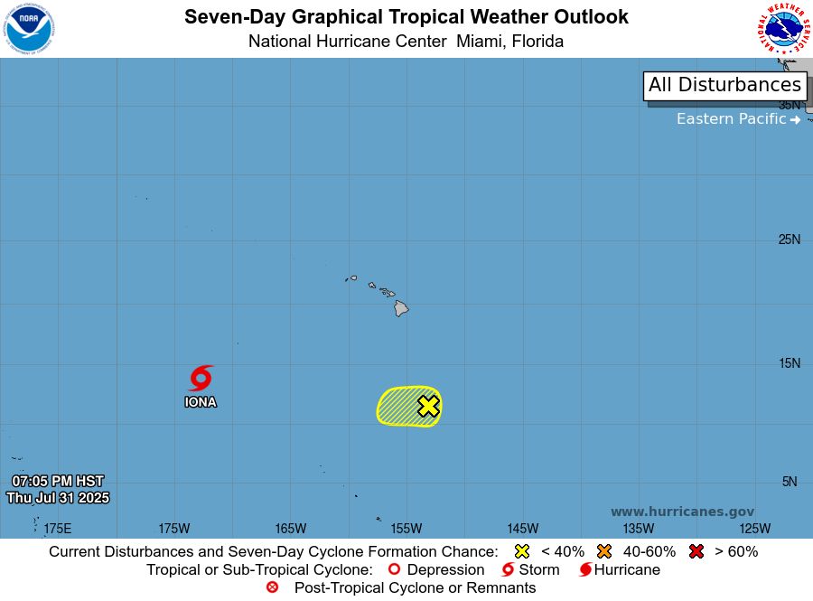
tropical weather outlook over the next 2 days greyscale satellite image of Central Pacific Ocean for
NWS Central Pacific Hurricane Center Honolulu HI
Issued by NWS National Hurricane Center Miami FL
800 PM HST Thu Jul 31 2025
For the central North Pacific...between 140W and 180W:
Active Systems:
The National Hurricane Center is issuing advisories on Tropical
Storm Iona, located in the central Pacific basin well west-southwest
of the Hawaiian Islands and Tropical Storm Gil, located well
southwest of the southern Baja California peninsula.
1. Well South-Southeast of the Hawaiian Islands (CP92):
Disorganized showers and thunderstorms associated with a trough of
low pressure located about 650 miles south-southeast of Hilo,
Hawaii, continue to persist. While the system currently lacks a
well-defined low-level center, some development is possible during
the next day or so. By this weekend, environmental conditions are
expected to become less conducive for further development.
* Formation chance through 48 hours...low...10 percent.
* Formation chance through 7 days...low...10 percent.
Public Advisories on Tropical Storm Gil are issued under WMO header
WTPZ32 KNHC and under AWIPS header MIATCPEP2.
Forecast/Advisories on Tropical Storm Gil are issued under WMO
header WTPZ22 KNHC and under AWIPS header MIATCMEP2.
Forecaster Gibbs/Hagen
tropical weather outlook over the next 7 days color illustrated image of Central Pacific Ocean for
NWS Central Pacific Hurricane Center Honolulu HI
Issued by NWS National Hurricane Center Miami FL
800 PM HST Thu Jul 31 2025
For the central North Pacific...between 140W and 180W:
Active Systems:
The National Hurricane Center is issuing advisories on Tropical
Storm Iona, located in the central Pacific basin well west-southwest
of the Hawaiian Islands and Tropical Storm Gil, located well
southwest of the southern Baja California peninsula.
1. Well South-Southeast of the Hawaiian Islands (CP92):
Disorganized showers and thunderstorms associated with a trough of
low pressure located about 650 miles south-southeast of Hilo,
Hawaii, continue to persist. While the system currently lacks a
well-defined low-level center, some development is possible during
the next day or so. By this weekend, environmental conditions are
expected to become less conducive for further development.
* Formation chance through 48 hours...low...10 percent.
* Formation chance through 7 days...low...10 percent.
Public Advisories on Tropical Storm Gil are issued under WMO header
WTPZ32 KNHC and under AWIPS header MIATCPEP2.
Forecast/Advisories on Tropical Storm Gil are issued under WMO
header WTPZ22 KNHC and under AWIPS header MIATCMEP2.
Forecaster Gibbs/Hagen
NWS Central Pacific Hurricane Center Honolulu HI
Issued by NWS National Hurricane Center Miami FL
800 PM HST Thu Jul 31 2025
For the central North Pacific...between 140W and 180W:
Active Systems:
The National Hurricane Center is issuing advisories on Tropical
Storm Iona, located in the central Pac
01.08.2025 06:14 — 👍 1 🔁 0 💬 0 📌 0