tropical weather outlook over the next 2 days greyscale satellite image of Eastern Pacific Ocean for
NWS National Hurricane Center Miami FL
1100 AM PDT Fri Aug 8 2025
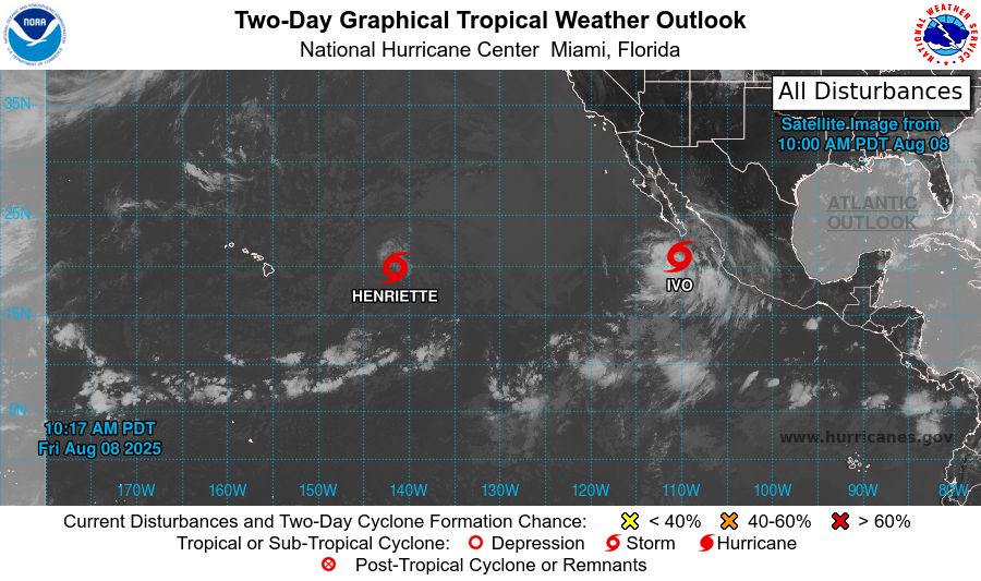
For the eastern and central North Pacific east of 180 longitude:
Active Systems:
The National Hurricane Center is issuing advisories on Tropical
Storm Henriette, located in the Central Pacific basin well east of
the Hawaiian Islands. The National Hurricane Center is also issuing
advisories on Tropical Storm Ivo, located over the Eastern Pacific
basin about 160 miles south-southwest of the southern tip of the
Baja California peninsula.
Tropical cyclone formation is not expected during the next 7 days.
$$
Forecaster Hagen
NNNN
tropical weather outlook over the next 7 days color illustrated image of Eastern Pacific Ocean for
NWS National Hurricane Center Miami FL
1100 AM PDT Fri Aug 8 2025
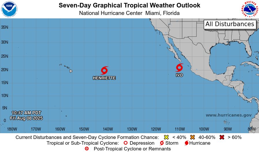
For the eastern and central North Pacific east of 180 longitude:
Active Systems:
The National Hurricane Center is issuing advisories on Tropical
Storm Henriette, located in the Central Pacific basin well east of
the Hawaiian Islands. The National Hurricane Center is also issuing
advisories on Tropical Storm Ivo, located over the Eastern Pacific
basin about 160 miles south-southwest of the southern tip of the
Baja California peninsula.
Tropical cyclone formation is not expected during the next 7 days.
$$
Forecaster Hagen
NNNN
NWS National Hurricane Center Miami FL
1100 AM PDT Fri Aug 8 2025
For the eastern and central North Pacific east of 180 longitude:
Active Systems:
The National Hurricane Center is issuing advisories on Tropical
Storm Henriette, located in the Central Pacific basin well east of
the Hawaiian Isla
08.08.2025 18:09 — 👍 0 🔁 0 💬 0 📌 0
tropical weather outlook over the next 2 days greyscale satellite image of Eastern Pacific Ocean for
NWS National Hurricane Center Miami FL
500 AM PDT Fri Aug 8 2025
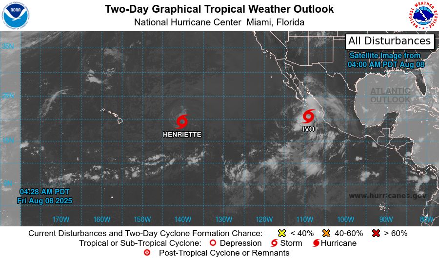
For the eastern and central North Pacific east of 180 longitude:
Active Systems:
The National Hurricane Center is issuing advisories on Tropical
Storm Henriette, located in the Central Pacific basin well east of
the Hawaiian Islands. The National Hurricane Center is also issuing
advisories on Tropical Storm Ivo, located over the Eastern Pacific
basin about 160 miles south of the southern tip of the Baja
California peninsula.
Tropical cyclone formation is not expected during the next 7 days.
$$
Forecaster Hagen
NNNN

tropical weather outlook over the next 7 days color illustrated image of Eastern Pacific Ocean for
NWS National Hurricane Center Miami FL
500 AM PDT Fri Aug 8 2025
For the eastern and central North Pacific east of 180 longitude:
Active Systems:
The National Hurricane Center is issuing advisories on Tropical
Storm Henriette, located in the Central Pacific basin well east of
the Hawaiian Islands. The National Hurricane Center is also issuing
advisories on Tropical Storm Ivo, located over the Eastern Pacific
basin about 160 miles south of the southern tip of the Baja
California peninsula.
Tropical cyclone formation is not expected during the next 7 days.
$$
Forecaster Hagen
NNNN
NWS National Hurricane Center Miami FL
500 AM PDT Fri Aug 8 2025
For the eastern and central North Pacific east of 180 longitude:
Active Systems:
The National Hurricane Center is issuing advisories on Tropical
Storm Henriette, located in the Central Pacific basin well east of
the Hawaiian Islan
08.08.2025 12:15 — 👍 2 🔁 1 💬 0 📌 0
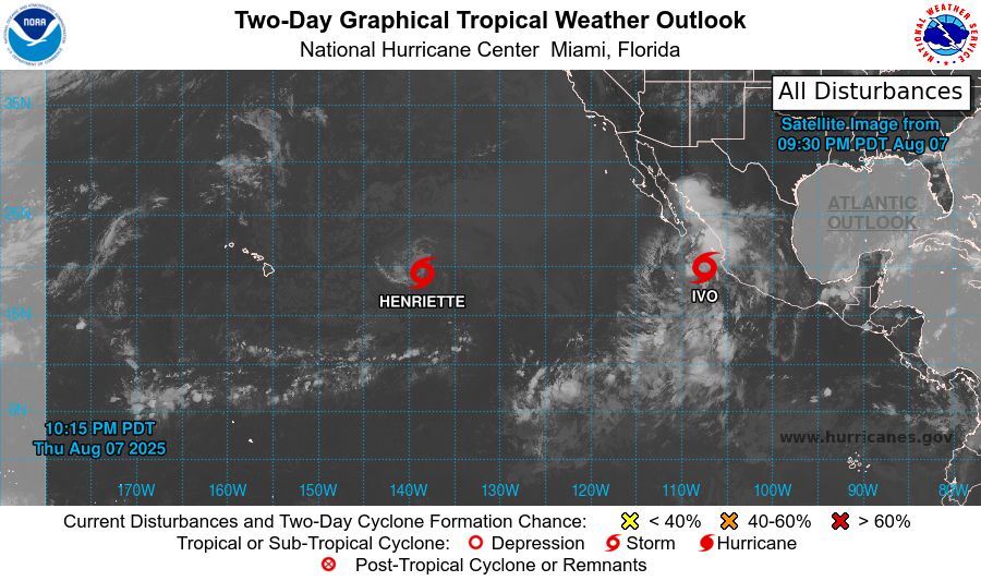
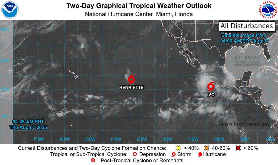
tropical weather outlook over the next 2 days greyscale satellite image of Eastern Pacific Ocean for
NWS National Hurricane Center Miami FL
1100 PM PDT Thu Aug 7 2025
For the eastern and central North Pacific east of 180 longitude:
Active Systems:
The National Hurricane Center is issuing advisories on Tropical
Storm Henriette, located well east of the Hawaiian Islands.
Henriette is expected to move into the Central Pacific basin later
tonight. The National Hurricane Center is also issuing advisories on
Tropical Storm Ivo, located over the eastern Pacific offshore of the
coast of West-Central Mexico.
Tropical cyclone formation is not expected over the next 7 days.
$$
Forecaster Jelsema
NNNN

tropical weather outlook over the next 7 days color illustrated image of Eastern Pacific Ocean for
NWS National Hurricane Center Miami FL
1100 PM PDT Thu Aug 7 2025
For the eastern and central North Pacific east of 180 longitude:
Active Systems:
The National Hurricane Center is issuing advisories on Tropical
Storm Henriette, located well east of the Hawaiian Islands.
Henriette is expected to move into the Central Pacific basin later
tonight. The National Hurricane Center is also issuing advisories on
Tropical Storm Ivo, located over the eastern Pacific offshore of the
coast of West-Central Mexico.
Tropical cyclone formation is not expected over the next 7 days.
$$
Forecaster Jelsema
NNNN
NWS National Hurricane Center Miami FL
1100 PM PDT Thu Aug 7 2025
For the eastern and central North Pacific east of 180 longitude:
Active Systems:
The National Hurricane Center is issuing advisories on Tropical
Storm Henriette, located well east of the Hawaiian Islands.
Henriette is expected to
08.08.2025 06:14 — 👍 0 🔁 0 💬 0 📌 0
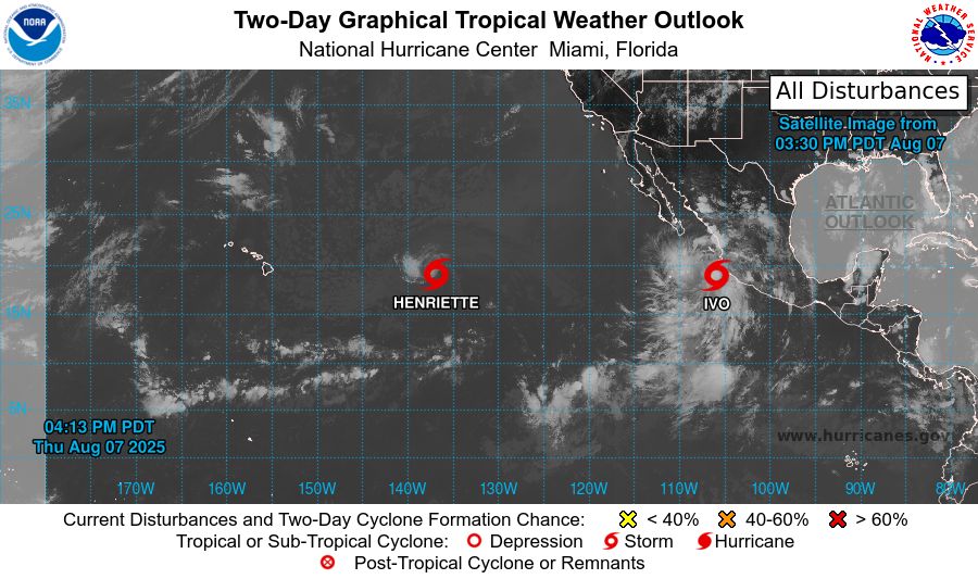
tropical weather outlook over the next 2 days greyscale satellite image of Eastern Pacific Ocean for
NWS National Hurricane Center Miami FL
500 PM PDT Thu Aug 7 2025
For the eastern and central North Pacific east of 180 longitude:
Active Systems:
The National Hurricane Center is issuing advisories on Tropical
Storm Henriette, located well east of the Hawaiian Islands.
Henriette is expected to move into the Central Pacific basin by
tonight. The National Hurricane Center is also issuing
advisories on Tropical Storm Ivo, located over the eastern
Pacific offshore of the coast of Southwestern Mexico.
Tropical cyclone formation is not expected over the next 7 days.
$$
Forecaster Jelsema
NNNN

tropical weather outlook over the next 7 days color illustrated image of Eastern Pacific Ocean for
NWS National Hurricane Center Miami FL
500 PM PDT Thu Aug 7 2025
For the eastern and central North Pacific east of 180 longitude:
Active Systems:
The National Hurricane Center is issuing advisories on Tropical
Storm Henriette, located well east of the Hawaiian Islands.
Henriette is expected to move into the Central Pacific basin by
tonight. The National Hurricane Center is also issuing
advisories on Tropical Storm Ivo, located over the eastern
Pacific offshore of the coast of Southwestern Mexico.
Tropical cyclone formation is not expected over the next 7 days.
$$
Forecaster Jelsema
NNNN
NWS National Hurricane Center Miami FL
500 PM PDT Thu Aug 7 2025
For the eastern and central North Pacific east of 180 longitude:
Active Systems:
The National Hurricane Center is issuing advisories on Tropical
Storm Henriette, located well east of the Hawaiian Islands.
Henriette is expected to
08.08.2025 00:39 — 👍 1 🔁 1 💬 0 📌 0
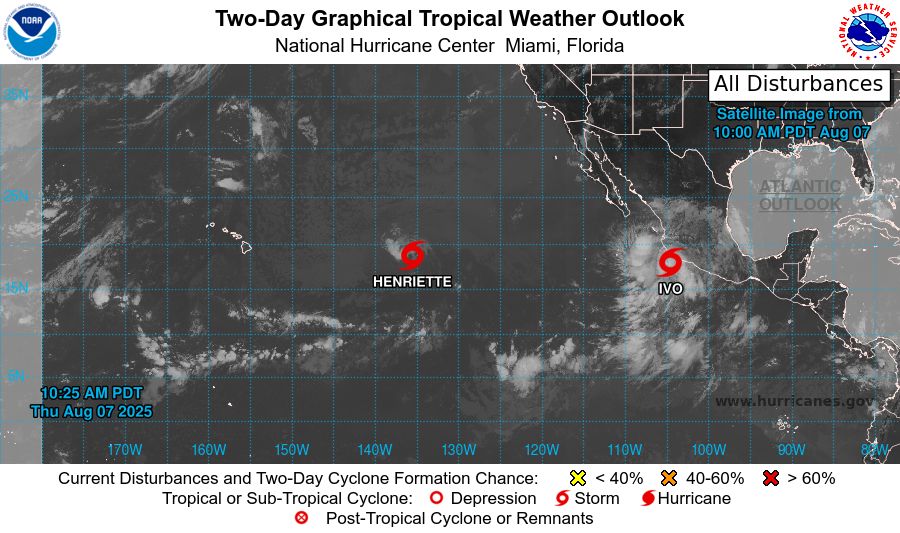
tropical weather outlook over the next 2 days greyscale satellite image of Eastern Pacific Ocean for
NWS National Hurricane Center Miami FL
1100 AM PDT Thu Aug 7 2025
For the eastern and central North Pacific east of 180 longitude:
Active Systems:
The National Hurricane Center is issuing advisories on Tropical
Storm Henriette, located well east of the Hawaiian Islands.
Henriette is expected to move into the Central Pacific basin by
tonight. The National Hurricane Center is also issuing
advisories on Tropical Storm Ivo, located over the eastern
Pacific offshore of the coast of Southwestern Mexico.
Tropical cyclone formation is not expected over the next 7 days.
&&
Public Advisories on Tropical Storm Ivo are issued under WMO
header WTPZ34 KNHC and under AWIPS header MIATCPEP4.
Forecast/Advisories on Tropical Storm Ivo are issued under
WMO header WTPZ24 KNHC and under AWIPS header MIATCMEP4.
$$
Forecaster Papin
NNNN
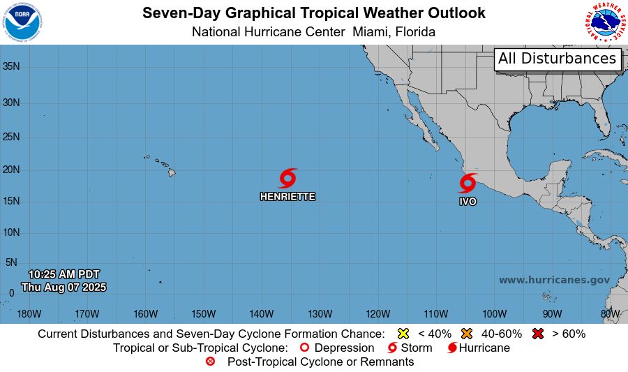
tropical weather outlook over the next 7 days color illustrated image of Eastern Pacific Ocean for
NWS National Hurricane Center Miami FL
1100 AM PDT Thu Aug 7 2025
For the eastern and central North Pacific east of 180 longitude:
Active Systems:
The National Hurricane Center is issuing advisories on Tropical
Storm Henriette, located well east of the Hawaiian Islands.
Henriette is expected to move into the Central Pacific basin by
tonight. The National Hurricane Center is also issuing
advisories on Tropical Storm Ivo, located over the eastern
Pacific offshore of the coast of Southwestern Mexico.
Tropical cyclone formation is not expected over the next 7 days.
&&
Public Advisories on Tropical Storm Ivo are issued under WMO
header WTPZ34 KNHC and under AWIPS header MIATCPEP4.
Forecast/Advisories on Tropical Storm Ivo are issued under
WMO header WTPZ24 KNHC and under AWIPS header MIATCMEP4.
$$
Forecaster Papin
NNNN
NWS National Hurricane Center Miami FL
1100 AM PDT Thu Aug 7 2025
For the eastern and central North Pacific east of 180 longitude:
Active Systems:
The National Hurricane Center is issuing advisories on Tropical
Storm Henriette, located well east of the Hawaiian Islands.
Henriette is expected to
07.08.2025 18:12 — 👍 0 🔁 0 💬 0 📌 0
tropical weather outlook over the next 2 days greyscale satellite image of Eastern Pacific Ocean for
NWS National Hurricane Center Miami FL
500 AM PDT Thu Aug 7 2025
For the eastern and central North Pacific east of 180 longitude:
Active Systems:
The National Hurricane Center is issuing advisories on Tropical
Storm Henriette, located well east of the Hawaiian Islands.
Henriette is expected to move into the Central Pacific basin
Thursday night. The National Hurricane Center is also issuing
advisories on Tropical Storm Ivo, located offshore of the coast of
Southwestern Mexico.
Tropical cyclone formation is not expected over the next 7 days.
&&
Public Advisories on Tropical Storm Ivo are issued under WMO
header WTPZ34 KNHC and under AWIPS header MIATCPEP4.
Forecast/Advisories on Tropical Storm Ivo are issued under
WMO header WTPZ24 KNHC and under AWIPS header MIATCMEP4.
$$
Forecaster Papin
NNNN

tropical weather outlook over the next 7 days color illustrated image of Eastern Pacific Ocean for
NWS National Hurricane Center Miami FL
500 AM PDT Thu Aug 7 2025
For the eastern and central North Pacific east of 180 longitude:
Active Systems:
The National Hurricane Center is issuing advisories on Tropical
Storm Henriette, located well east of the Hawaiian Islands.
Henriette is expected to move into the Central Pacific basin
Thursday night. The National Hurricane Center is also issuing
advisories on Tropical Storm Ivo, located offshore of the coast of
Southwestern Mexico.
Tropical cyclone formation is not expected over the next 7 days.
&&
Public Advisories on Tropical Storm Ivo are issued under WMO
header WTPZ34 KNHC and under AWIPS header MIATCPEP4.
Forecast/Advisories on Tropical Storm Ivo are issued under
WMO header WTPZ24 KNHC and under AWIPS header MIATCMEP4.
$$
Forecaster Papin
NNNN
NWS National Hurricane Center Miami FL
500 AM PDT Thu Aug 7 2025
For the eastern and central North Pacific east of 180 longitude:
Active Systems:
The National Hurricane Center is issuing advisories on Tropical
Storm Henriette, located well east of the Hawaiian Islands.
Henriette is expected to
07.08.2025 12:15 — 👍 0 🔁 0 💬 0 📌 0
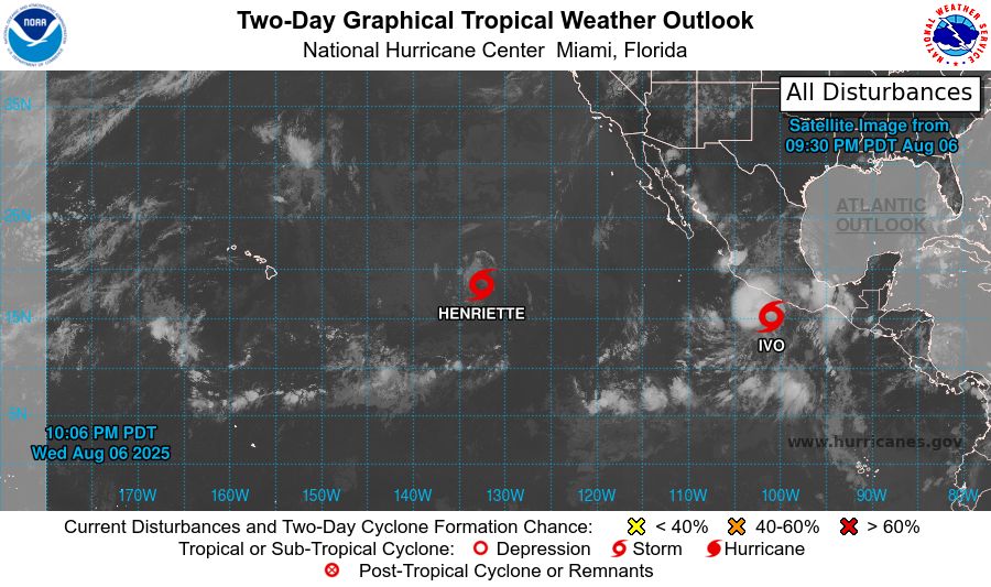
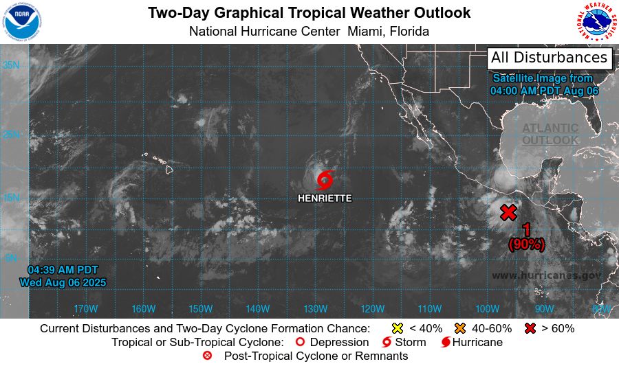
tropical weather outlook over the next 2 days greyscale satellite image of Eastern Pacific Ocean for
NWS National Hurricane Center Miami FL
1100 PM PDT Wed Aug 6 2025
For the eastern and central North Pacific east of 180 longitude:
Active Systems:
The National Hurricane Center is issuing advisories on Tropical
Storm Henriette, located well east of the Hawaiian Islands.
Henriette is expected to move into the Central Pacific basin
Thursday night.
The National Hurricane Center is also issuing
advisories on Tropical Storm Ivo, located about 150 miles offshore
the coast of Southwestern Mexico.
Tropical cyclone formation is not expected over the next 7 days.
&&
Public Advisories on Tropical Storm Ivo are issued under WMO
header WTPZ34 KNHC and under AWIPS header MIATCPEP4.
Forecast/Advisories on Tropical Storm Ivo are issued under
WMO header WTPZ24 KNHC and under AWIPS header MIATCMEP4.
$$
Forecaster Jelsema/Bucci
NNNN

tropical weather outlook over the next 7 days color illustrated image of Eastern Pacific Ocean for
NWS National Hurricane Center Miami FL
1100 PM PDT Wed Aug 6 2025
For the eastern and central North Pacific east of 180 longitude:
Active Systems:
The National Hurricane Center is issuing advisories on Tropical
Storm Henriette, located well east of the Hawaiian Islands.
Henriette is expected to move into the Central Pacific basin
Thursday night.
The National Hurricane Center is also issuing
advisories on Tropical Storm Ivo, located about 150 miles offshore
the coast of Southwestern Mexico.
Tropical cyclone formation is not expected over the next 7 days.
&&
Public Advisories on Tropical Storm Ivo are issued under WMO
header WTPZ34 KNHC and under AWIPS header MIATCPEP4.
Forecast/Advisories on Tropical Storm Ivo are issued under
WMO header WTPZ24 KNHC and under AWIPS header MIATCMEP4.
$$
Forecaster Jelsema/Bucci
NNNN
NWS National Hurricane Center Miami FL
1100 PM PDT Wed Aug 6 2025
For the eastern and central North Pacific east of 180 longitude:
Active Systems:
The National Hurricane Center is issuing advisories on Tropical
Storm Henriette, located well east of the Hawaiian Islands.
Henriette is expected to
07.08.2025 06:14 — 👍 0 🔁 0 💬 0 📌 0
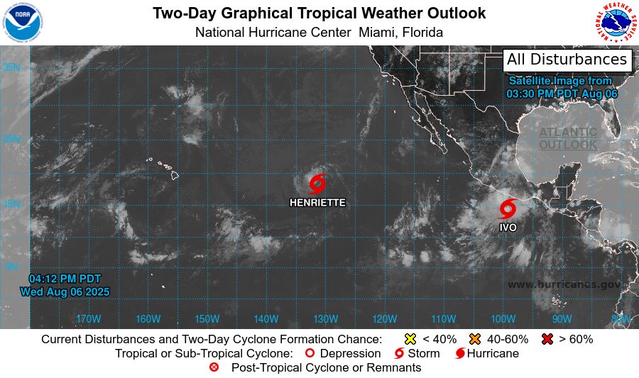
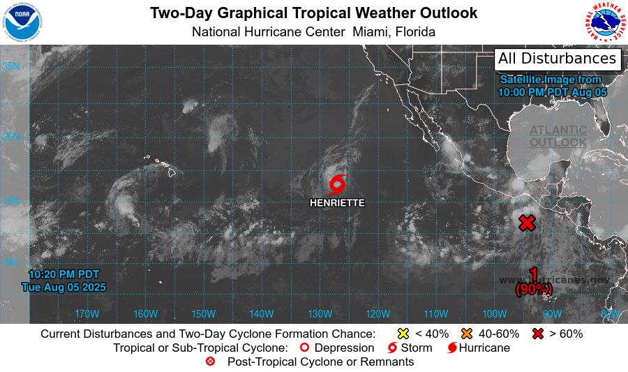
tropical weather outlook over the next 2 days greyscale satellite image of Eastern Pacific Ocean for
NWS National Hurricane Center Miami FL
500 PM PDT Wed Aug 6 2025
For the eastern and central North Pacific east of 180 longitude:
Active Systems:
The National Hurricane Center is issuing advisories on Tropical
Storm Henriette, located well east of the Hawaiian Islands.
Henriette is expected to move into the Central Pacific basin
Thursday night.
The National Hurricane Center is also issuing advisories on Tropical
Storm Ivo, located a couple hundred miles offshore the coast of
Southern Mexico.
Tropical cyclone formation is not expected over the next 7 days.
&&
Public Advisories on Tropical Storm Ivo are issued under WMO
header WTPZ34 KNHC and under AWIPS header MIATCPEP4.
Forecast/Advisories on Tropical Storm Ivo are issued under
WMO header WTPZ24 KNHC and under AWIPS header MIATCMEP4.
$$
Forecaster Jelsema
NNNN

tropical weather outlook over the next 7 days color illustrated image of Eastern Pacific Ocean for
NWS National Hurricane Center Miami FL
500 PM PDT Wed Aug 6 2025
For the eastern and central North Pacific east of 180 longitude:
Active Systems:
The National Hurricane Center is issuing advisories on Tropical
Storm Henriette, located well east of the Hawaiian Islands.
Henriette is expected to move into the Central Pacific basin
Thursday night.
The National Hurricane Center is also issuing advisories on Tropical
Storm Ivo, located a couple hundred miles offshore the coast of
Southern Mexico.
Tropical cyclone formation is not expected over the next 7 days.
&&
Public Advisories on Tropical Storm Ivo are issued under WMO
header WTPZ34 KNHC and under AWIPS header MIATCPEP4.
Forecast/Advisories on Tropical Storm Ivo are issued under
WMO header WTPZ24 KNHC and under AWIPS header MIATCMEP4.
$$
Forecaster Jelsema
NNNN
NWS National Hurricane Center Miami FL
500 PM PDT Wed Aug 6 2025
For the eastern and central North Pacific east of 180 longitude:
Active Systems:
The National Hurricane Center is issuing advisories on Tropical
Storm Henriette, located well east of the Hawaiian Islands.
Henriette is expected to
07.08.2025 00:40 — 👍 0 🔁 0 💬 0 📌 0
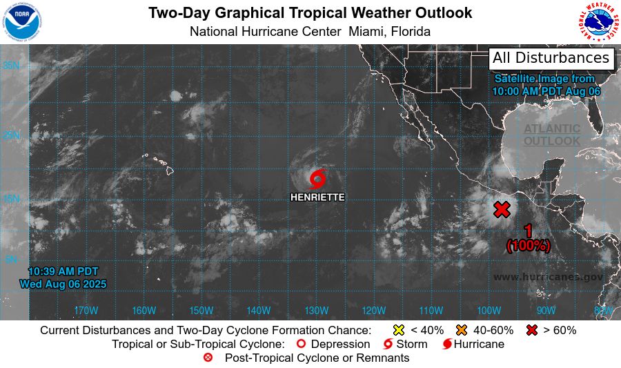
tropical weather outlook over the next 2 days greyscale satellite image of Eastern Pacific Ocean for
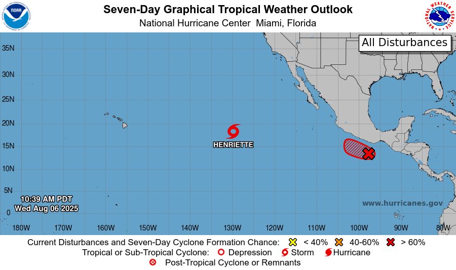
NWS National Hurricane Center Miami FL
1100 AM PDT Wed Aug 6 2025
For the eastern and central North Pacific east of 180 longitude:
Active Systems:
The National Hurricane Center is issuing advisories on Tropical
Storm Henriette, located well east of the Hawaiian Islands.
Henriette is expected to move into the Central Pacific basin
Thursday night.
1. South of Southern Mexico (EP91):
Microwave satellite imagery and derived surface wind data indicate
that the disturbance located a few hundred miles southwest of the
Gulf of Tehuantepec has become better organized this morning. If
current trends continue, advisories will likely be initiated for
either a tropical depression or tropical storm this afternoon. The
system is forecast to continue moving generally west-northwestward
at 15 to 20 mph, parallel to, but offshore of the coast of Mexico.
Regardless of the system's formation or exact track, heavy rainfall
is possible along the southern coast of Mexico today and tomorrow.
For additional information, including storm warnings, please see
High Seas Forecasts issued by the National Weather Service.
* Formation chance through 48 hours...high...near 100 percent.
* Formation chance through 7 days...high...near 100 percent.
High Seas Forecasts issued by the National Weather Service
can be found under AWIPS header NFDHSFEPI, WMO header FZPN02
KWBC, and on the web at ocean.weather.gov/shtml/NFDHSFEPI.php
Forecaster D. Zelinsky/Santos
tropical weather outlook over the next 7 days color illustrated image of Eastern Pacific Ocean for
NWS National Hurricane Center Miami FL
1100 AM PDT Wed Aug 6 2025
For the eastern and central North Pacific east of 180 longitude:
Active Systems:
The National Hurricane Center is issuing advisories on Tropical
Storm Henriette, located well east of the Hawaiian Islands.
Henriette is expected to move into the Central Pacific basin
Thursday night.
1. South of Southern Mexico (EP91):
Microwave satellite imagery and derived surface wind data indicate
that the disturbance located a few hundred miles southwest of the
Gulf of Tehuantepec has become better organized this morning. If
current trends continue, advisories will likely be initiated for
either a tropical depression or tropical storm this afternoon. The
system is forecast to continue moving generally west-northwestward
at 15 to 20 mph, parallel to, but offshore of the coast of Mexico.
Regardless of the system's formation or exact track, heavy rainfall
is possible along the southern coast of Mexico today and tomorrow.
For additional information, including storm warnings, please see
High Seas Forecasts issued by the National Weather Service.
* Formation chance through 48 hours...high...near 100 percent.
* Formation chance through 7 days...high...near 100 percent.
High Seas Forecasts issued by the National Weather Service
can be found under AWIPS header NFDHSFEPI, WMO header FZPN02
KWBC, and on the web at ocean.weather.gov/shtml/NFDHSFEPI.php
Forecaster D. Zelinsky/Santos
NWS National Hurricane Center Miami FL
1100 AM PDT Wed Aug 6 2025
For the eastern and central North Pacific east of 180 longitude:
Active Systems:
The National Hurricane Center is issuing advisories on Tropical
Storm Henriette, located well east of the Hawaiian Islands.
Henriette is expected to
06.08.2025 18:12 — 👍 3 🔁 0 💬 0 📌 0
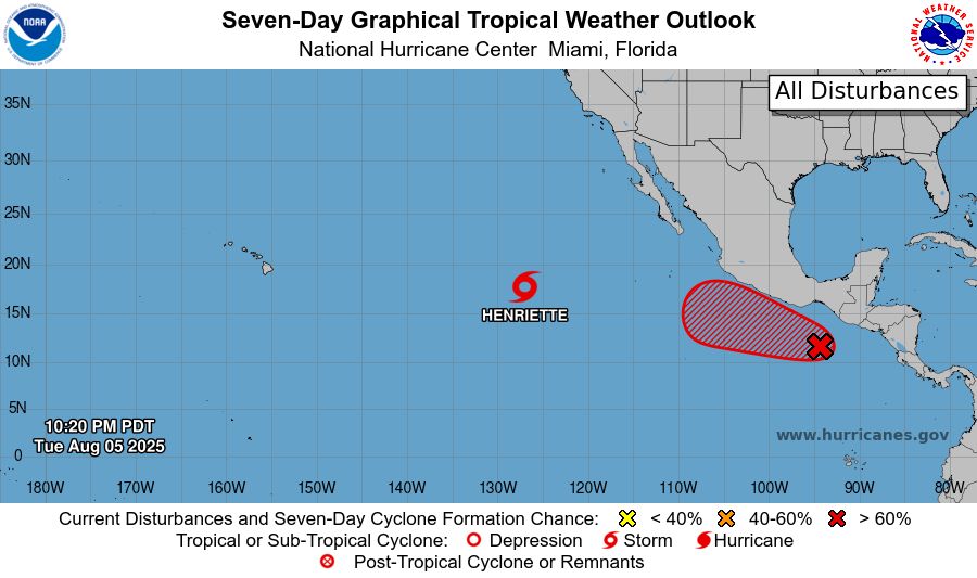
tropical weather outlook over the next 2 days greyscale satellite image of Eastern Pacific Ocean for
NWS National Hurricane Center Miami FL
500 AM PDT Wed Aug 6 2025
For the eastern and central North Pacific east of 180 longitude:
Active Systems:
The National Hurricane Center is issuing advisories on Tropical
Storm Henriette, located well east of the Hawaiian Islands.
Henriette is expected to move into the Central Pacific basin
Thursday night.
1. South of Southern Mexico (EP91):
Shower and thunderstorm activity associated with an area of low
pressure located a couple of hundred miles south-southwest of the
Gulf of Tehuantepec has increased during the past few hours.
Continued development is expected and a tropical depression or
tropical storm will likely form during the next day or so. The
system is forecast to move generally west-northwestward around 15
mph, parallel to but offshore of the coast of Mexico. For additional
information, including gale warnings, please see High Seas Forecasts
issued by the National Weather Service.
* Formation chance through 48 hours...high...90 percent.
* Formation chance through 7 days...high...90 percent.
High Seas Forecasts issued by the National Weather Service
can be found under AWIPS header NFDHSFEPI, WMO header FZPN02
KWBC, and on the web at ocean.weather.gov/shtml/NFDHSFEPI.php
Forecaster D. Zelinsky/Santos

tropical weather outlook over the next 7 days color illustrated image of Eastern Pacific Ocean for
NWS National Hurricane Center Miami FL
500 AM PDT Wed Aug 6 2025
For the eastern and central North Pacific east of 180 longitude:
Active Systems:
The National Hurricane Center is issuing advisories on Tropical
Storm Henriette, located well east of the Hawaiian Islands.
Henriette is expected to move into the Central Pacific basin
Thursday night.
1. South of Southern Mexico (EP91):
Shower and thunderstorm activity associated with an area of low
pressure located a couple of hundred miles south-southwest of the
Gulf of Tehuantepec has increased during the past few hours.
Continued development is expected and a tropical depression or
tropical storm will likely form during the next day or so. The
system is forecast to move generally west-northwestward around 15
mph, parallel to but offshore of the coast of Mexico. For additional
information, including gale warnings, please see High Seas Forecasts
issued by the National Weather Service.
* Formation chance through 48 hours...high...90 percent.
* Formation chance through 7 days...high...90 percent.
High Seas Forecasts issued by the National Weather Service
can be found under AWIPS header NFDHSFEPI, WMO header FZPN02
KWBC, and on the web at ocean.weather.gov/shtml/NFDHSFEPI.php
Forecaster D. Zelinsky/Santos
NWS National Hurricane Center Miami FL
500 AM PDT Wed Aug 6 2025
For the eastern and central North Pacific east of 180 longitude:
Active Systems:
The National Hurricane Center is issuing advisories on Tropical
Storm Henriette, located well east of the Hawaiian Islands.
Henriette is expected to
06.08.2025 12:16 — 👍 0 🔁 0 💬 0 📌 0
tropical weather outlook over the next 2 days greyscale satellite image of Eastern Pacific Ocean for
NWS National Hurricane Center Miami FL
1100 PM PDT Tue Aug 5 2025
For the eastern and central North Pacific east of 180 longitude:
Active Systems:
The National Hurricane Center is issuing advisories on Tropical
Storm Henriette, located well east of the Hawaiian Islands.
Henriette is expected to move into the Central Pacific basin
Thursday night.
1. South of Southern Mexico (EP91):
Showers and thunderstorms associated with an area of low pressure
located a few hundred miles south of the Gulf of Tehuantepec
continue to show signs of organization. Environmental conditions
are conducive for development of this system, and a tropical
depression is expected to form during the next day or two while the
low moves west-northwestward around 15 mph. For additional
information, including gale warnings, please see High Seas Forecasts
issued by the National Weather Service.
* Formation chance through 48 hours...high...90 percent.
* Formation chance through 7 days...high...90 percent.
High Seas Forecasts issued by the National Weather Service
can be found under AWIPS header NFDHSFEPI, WMO header FZPN02
KWBC, and on the web at ocean.weather.gov/shtml/NFDHSFEPI.php
Forecaster Jelsema
tropical weather outlook over the next 7 days color illustrated image of Eastern Pacific Ocean for
NWS National Hurricane Center Miami FL
1100 PM PDT Tue Aug 5 2025
For the eastern and central North Pacific east of 180 longitude:
Active Systems:
The National Hurricane Center is issuing advisories on Tropical
Storm Henriette, located well east of the Hawaiian Islands.
Henriette is expected to move into the Central Pacific basin
Thursday night.
1. South of Southern Mexico (EP91):
Showers and thunderstorms associated with an area of low pressure
located a few hundred miles south of the Gulf of Tehuantepec
continue to show signs of organization. Environmental conditions
are conducive for development of this system, and a tropical
depression is expected to form during the next day or two while the
low moves west-northwestward around 15 mph. For additional
information, including gale warnings, please see High Seas Forecasts
issued by the National Weather Service.
* Formation chance through 48 hours...high...90 percent.
* Formation chance through 7 days...high...90 percent.
High Seas Forecasts issued by the National Weather Service
can be found under AWIPS header NFDHSFEPI, WMO header FZPN02
KWBC, and on the web at ocean.weather.gov/shtml/NFDHSFEPI.php
Forecaster Jelsema
NWS National Hurricane Center Miami FL
1100 PM PDT Tue Aug 5 2025
For the eastern and central North Pacific east of 180 longitude:
Active Systems:
The National Hurricane Center is issuing advisories on Tropical
Storm Henriette, located well east of the Hawaiian Islands.
Henriette is expected to
06.08.2025 06:14 — 👍 0 🔁 0 💬 0 📌 0
tropical weather outlook over the next 2 days greyscale satellite image of Eastern Pacific Ocean for
NWS National Hurricane Center Miami FL
500 PM PDT Tue Aug 5 2025
For the eastern and central North Pacific east of 180 longitude:
Active Systems:
The National Hurricane Center is issuing advisories on Tropical
Storm Henriette, located well west-southwest of the Baja California
Peninsula. Henriette is expected to move into the Central Pacific
basin Thursday night or early Friday.
1. South of Southern Mexico (EP91):
Showers and thunderstorms associated with an area of low pressure
located a few hundred miles south of the Gulf of Tehuantepec are
showing signs of organization. Environmental conditions are
conducive for development of this system, and a tropical depression
is likely to form during the next couple of days while it moves
west-northwestward around 15 mph.
* Formation chance through 48 hours...high...80 percent.
* Formation chance through 7 days...high...90 percent.
Forecaster Jelsema

tropical weather outlook over the next 7 days color illustrated image of Eastern Pacific Ocean for
NWS National Hurricane Center Miami FL
500 PM PDT Tue Aug 5 2025
For the eastern and central North Pacific east of 180 longitude:
Active Systems:
The National Hurricane Center is issuing advisories on Tropical
Storm Henriette, located well west-southwest of the Baja California
Peninsula. Henriette is expected to move into the Central Pacific
basin Thursday night or early Friday.
1. South of Southern Mexico (EP91):
Showers and thunderstorms associated with an area of low pressure
located a few hundred miles south of the Gulf of Tehuantepec are
showing signs of organization. Environmental conditions are
conducive for development of this system, and a tropical depression
is likely to form during the next couple of days while it moves
west-northwestward around 15 mph.
* Formation chance through 48 hours...high...80 percent.
* Formation chance through 7 days...high...90 percent.
Forecaster Jelsema
NWS National Hurricane Center Miami FL
500 PM PDT Tue Aug 5 2025
For the eastern and central North Pacific east of 180 longitude:
Active Systems:
The National Hurricane Center is issuing advisories on Tropical
Storm Henriette, located well west-southwest of the Baja California
Peninsula. Henri
06.08.2025 00:40 — 👍 0 🔁 0 💬 0 📌 0
tropical weather outlook over the next 2 days greyscale satellite image of Eastern Pacific Ocean for
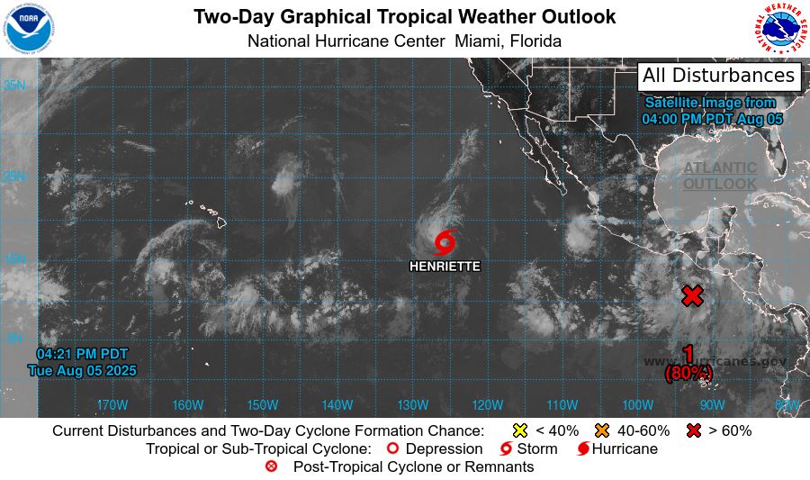
NWS National Hurricane Center Miami FL
1100 AM PDT Tue Aug 5 2025
For the eastern and central North Pacific east of 180 longitude:
Active Systems:
The National Hurricane Center is issuing advisories on Tropical
Storm Henriette, located well west-southwest of the Baja California
Peninsula. Henriette is expected to move into the Central Pacific
basin Thursday night or Friday morning.
1. South of Southern Mexico:
Showers and thunderstorms associated with an area of low pressure
located a couple hundred miles offshore of the coast of Central
America have become a little better organized. Environmental
conditions are conducive for development of this system, and a
tropical depression is likely to form during the next couple of days
while it moves west-northwestward around 15 mph.
* Formation chance through 48 hours...high...70 percent.
* Formation chance through 7 days...high...90 percent.
Forecaster Roberts

tropical weather outlook over the next 7 days color illustrated image of Eastern Pacific Ocean for
NWS National Hurricane Center Miami FL
1100 AM PDT Tue Aug 5 2025
For the eastern and central North Pacific east of 180 longitude:
Active Systems:
The National Hurricane Center is issuing advisories on Tropical
Storm Henriette, located well west-southwest of the Baja California
Peninsula. Henriette is expected to move into the Central Pacific
basin Thursday night or Friday morning.
1. South of Southern Mexico:
Showers and thunderstorms associated with an area of low pressure
located a couple hundred miles offshore of the coast of Central
America have become a little better organized. Environmental
conditions are conducive for development of this system, and a
tropical depression is likely to form during the next couple of days
while it moves west-northwestward around 15 mph.
* Formation chance through 48 hours...high...70 percent.
* Formation chance through 7 days...high...90 percent.
Forecaster Roberts
NWS National Hurricane Center Miami FL
1100 AM PDT Tue Aug 5 2025
For the eastern and central North Pacific east of 180 longitude:
Active Systems:
The National Hurricane Center is issuing advisories on Tropical
Storm Henriette, located well west-southwest of the Baja California
Peninsula. Henr
05.08.2025 18:12 — 👍 0 🔁 0 💬 0 📌 0
tropical weather outlook over the next 2 days greyscale satellite image of Eastern Pacific Ocean for
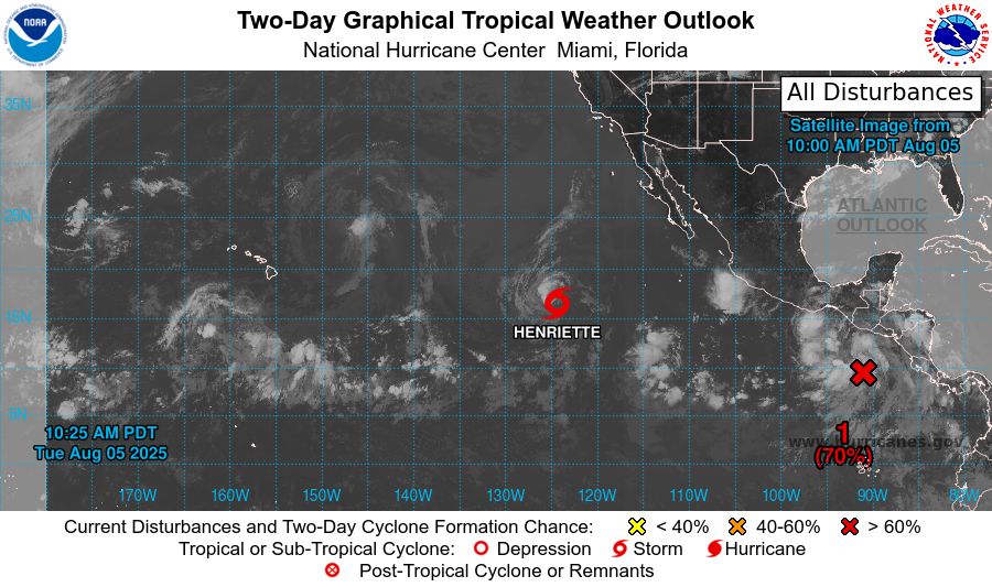
NWS National Hurricane Center Miami FL
500 AM PDT Tue Aug 5 2025
For the eastern and central North Pacific east of 180 longitude:
Active Systems:
The National Hurricane Center is issuing advisories on Tropical
Storm Henriette, located well southwest of the Baja California
Peninsula. Henriette is expected to move into the Central Pacific
basin Thursday night or Friday morning.
1. South of Southern Mexico:
An area of low pressure located a couple hundred miles offshore of
the coast of Central America is producing a large area of
disorganized showers and thunderstorms. Environmental conditions
appear conducive for development of this system, and a tropical
depression is likely to form during the next couple of days while
it moves west-northwestward around 15 mph.
* Formation chance through 48 hours...medium...60 percent.
* Formation chance through 7 days...high...90 percent.
Forecaster Roberts

tropical weather outlook over the next 7 days color illustrated image of Eastern Pacific Ocean for
NWS National Hurricane Center Miami FL
500 AM PDT Tue Aug 5 2025
For the eastern and central North Pacific east of 180 longitude:
Active Systems:
The National Hurricane Center is issuing advisories on Tropical
Storm Henriette, located well southwest of the Baja California
Peninsula. Henriette is expected to move into the Central Pacific
basin Thursday night or Friday morning.
1. South of Southern Mexico:
An area of low pressure located a couple hundred miles offshore of
the coast of Central America is producing a large area of
disorganized showers and thunderstorms. Environmental conditions
appear conducive for development of this system, and a tropical
depression is likely to form during the next couple of days while
it moves west-northwestward around 15 mph.
* Formation chance through 48 hours...medium...60 percent.
* Formation chance through 7 days...high...90 percent.
Forecaster Roberts
NWS National Hurricane Center Miami FL
500 AM PDT Tue Aug 5 2025
For the eastern and central North Pacific east of 180 longitude:
Active Systems:
The National Hurricane Center is issuing advisories on Tropical
Storm Henriette, located well southwest of the Baja California
Peninsula. Henriette
05.08.2025 12:16 — 👍 0 🔁 1 💬 0 📌 0
tropical weather outlook over the next 2 days greyscale satellite image of Eastern Pacific Ocean for
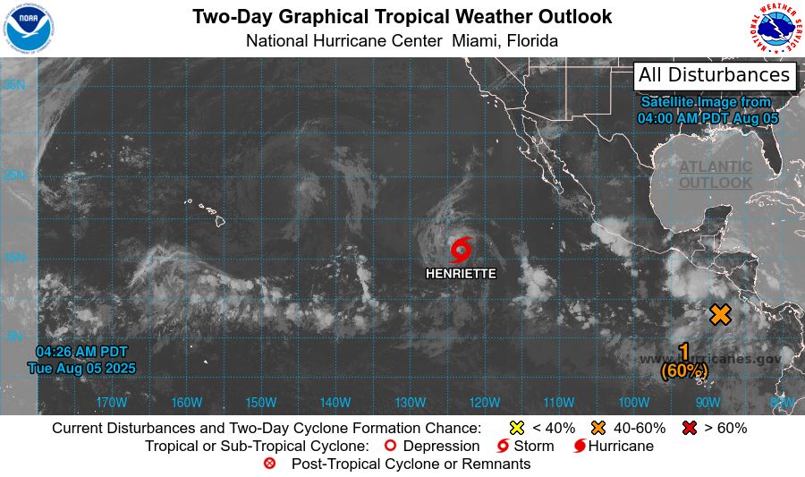
NWS National Hurricane Center Miami FL
1100 PM PDT Mon Aug 4 2025
For the eastern and central North Pacific east of 180 longitude:
Active Systems:
The National Hurricane Center is issuing advisories on Tropical
Storm Henriette, located well southwest of the Baja California
Peninsula. Henriette is expected to move into the Central Pacific
basin Thursday night or Friday.
1. South of Southern Mexico:
An area of low pressure located a couple hundred miles offshore of
the coast of Central America is producing a large area of
disorganized showers and thunderstorms. Environmental conditions
appear conducive for development of this system, and a tropical
depression is likely to form in a few days while it moves
west-northwestward around 15 mph.
* Formation chance through 48 hours...medium...50 percent.
* Formation chance through 7 days...high...80 percent.
Public advisories on Tropical Storm Henriette are issued under
WMO header WTPZ33 KNHC and under AWIPS header MIATCPEP3.
Forecast/Advisories on Tropical Storm Henriette are issued under
WMO header WTPZ23 KNHC and under AWIPS header MIATCMEP3.
Forecaster Jelsema
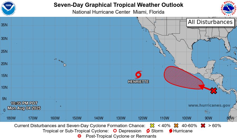
tropical weather outlook over the next 7 days color illustrated image of Eastern Pacific Ocean for
NWS National Hurricane Center Miami FL
1100 PM PDT Mon Aug 4 2025
For the eastern and central North Pacific east of 180 longitude:
Active Systems:
The National Hurricane Center is issuing advisories on Tropical
Storm Henriette, located well southwest of the Baja California
Peninsula. Henriette is expected to move into the Central Pacific
basin Thursday night or Friday.
1. South of Southern Mexico:
An area of low pressure located a couple hundred miles offshore of
the coast of Central America is producing a large area of
disorganized showers and thunderstorms. Environmental conditions
appear conducive for development of this system, and a tropical
depression is likely to form in a few days while it moves
west-northwestward around 15 mph.
* Formation chance through 48 hours...medium...50 percent.
* Formation chance through 7 days...high...80 percent.
Public advisories on Tropical Storm Henriette are issued under
WMO header WTPZ33 KNHC and under AWIPS header MIATCPEP3.
Forecast/Advisories on Tropical Storm Henriette are issued under
WMO header WTPZ23 KNHC and under AWIPS header MIATCMEP3.
Forecaster Jelsema
NWS National Hurricane Center Miami FL
1100 PM PDT Mon Aug 4 2025
For the eastern and central North Pacific east of 180 longitude:
Active Systems:
The National Hurricane Center is issuing advisories on Tropical
Storm Henriette, located well southwest of the Baja California
Peninsula. Henriette
05.08.2025 06:14 — 👍 0 🔁 0 💬 0 📌 0
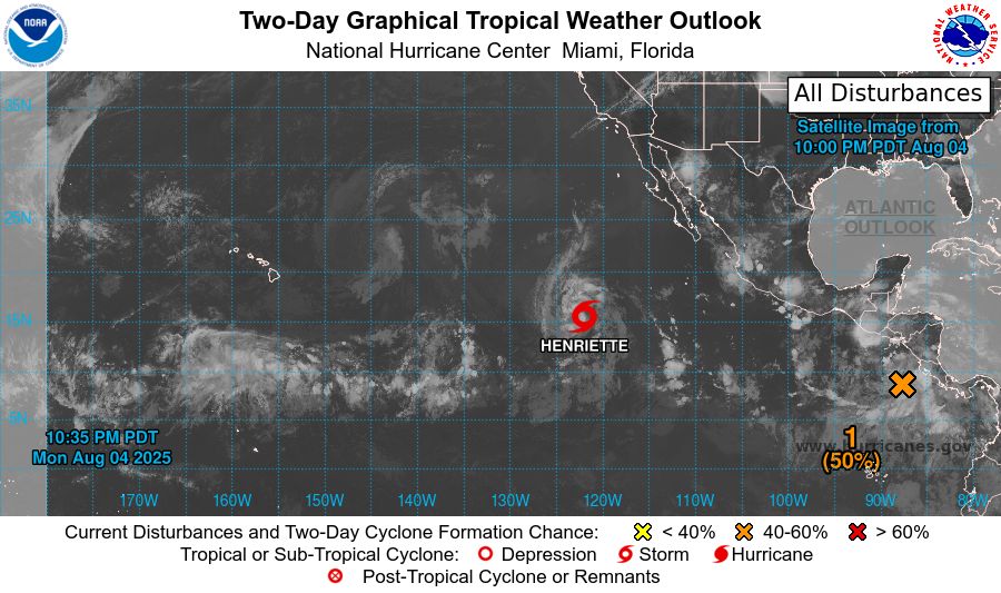
tropical weather outlook over the next 2 days greyscale satellite image of Eastern Pacific Ocean for
NWS National Hurricane Center Miami FL
500 PM PDT Mon Aug 4 2025
For the eastern and central North Pacific east of 180 longitude:
Active Systems:
The National Hurricane Center is issuing advisories on Tropical
Storm Henriette, located well southwest of the Baja California
Peninsula. Henriette is expected to move into the Central Pacific
basin Thursday night or Friday.
1. South of Southern Mexico:
An area of low pressure just offshore of the coast of Central
America is producing a large area of disorganized showers and
thunderstorms. Environmental conditions appear conducive for
development of this system, and a tropical depression is likely to
form later this week while the system moves west-northwestward
around 15 mph.
* Formation chance through 48 hours...low...30 percent.
* Formation chance through 7 days...high...80 percent.
Public advisories on Tropical Storm Henriette are issued under
WMO header WTPZ33 KNHC and under AWIPS header MIATCPEP3.
Forecast/Advisories on Tropical Storm Henriette are issued under
WMO header WTPZ23 KNHC and under AWIPS header MIATCMEP3.
Forecaster Jelsema

tropical weather outlook over the next 7 days color illustrated image of Eastern Pacific Ocean for
NWS National Hurricane Center Miami FL
500 PM PDT Mon Aug 4 2025
For the eastern and central North Pacific east of 180 longitude:
Active Systems:
The National Hurricane Center is issuing advisories on Tropical
Storm Henriette, located well southwest of the Baja California
Peninsula. Henriette is expected to move into the Central Pacific
basin Thursday night or Friday.
1. South of Southern Mexico:
An area of low pressure just offshore of the coast of Central
America is producing a large area of disorganized showers and
thunderstorms. Environmental conditions appear conducive for
development of this system, and a tropical depression is likely to
form later this week while the system moves west-northwestward
around 15 mph.
* Formation chance through 48 hours...low...30 percent.
* Formation chance through 7 days...high...80 percent.
Public advisories on Tropical Storm Henriette are issued under
WMO header WTPZ33 KNHC and under AWIPS header MIATCPEP3.
Forecast/Advisories on Tropical Storm Henriette are issued under
WMO header WTPZ23 KNHC and under AWIPS header MIATCMEP3.
Forecaster Jelsema
NWS National Hurricane Center Miami FL
500 PM PDT Mon Aug 4 2025
For the eastern and central North Pacific east of 180 longitude:
Active Systems:
The National Hurricane Center is issuing advisories on Tropical
Storm Henriette, located well southwest of the Baja California
Peninsula. Henriette
05.08.2025 00:40 — 👍 0 🔁 0 💬 0 📌 0
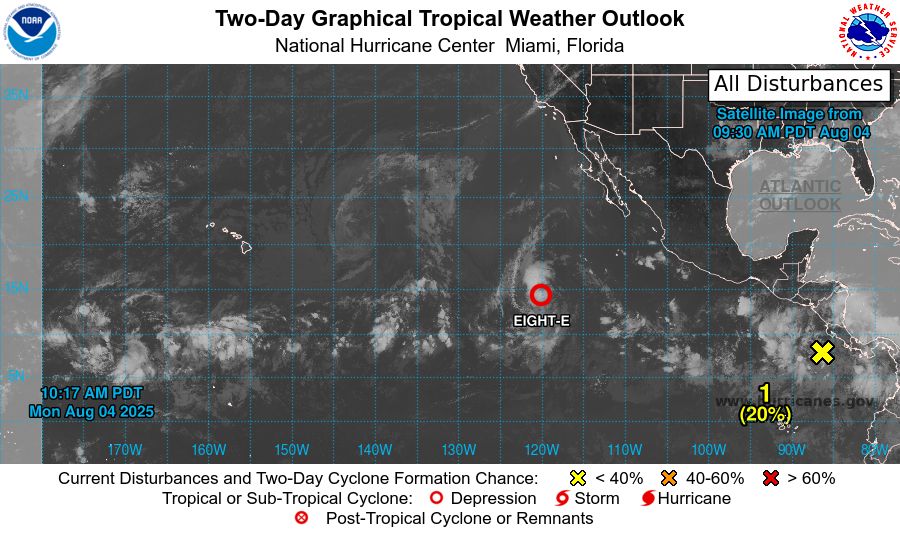
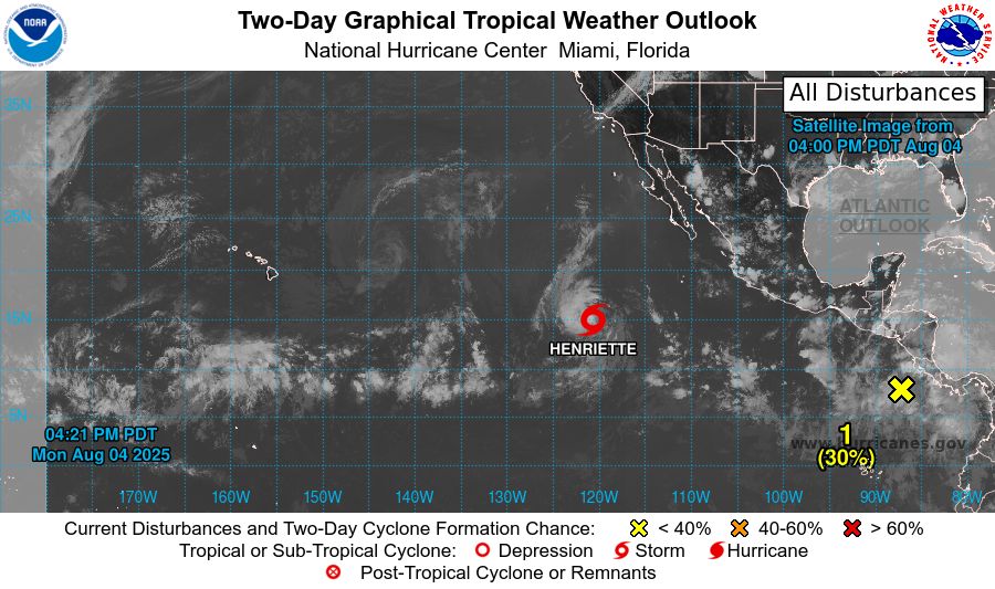
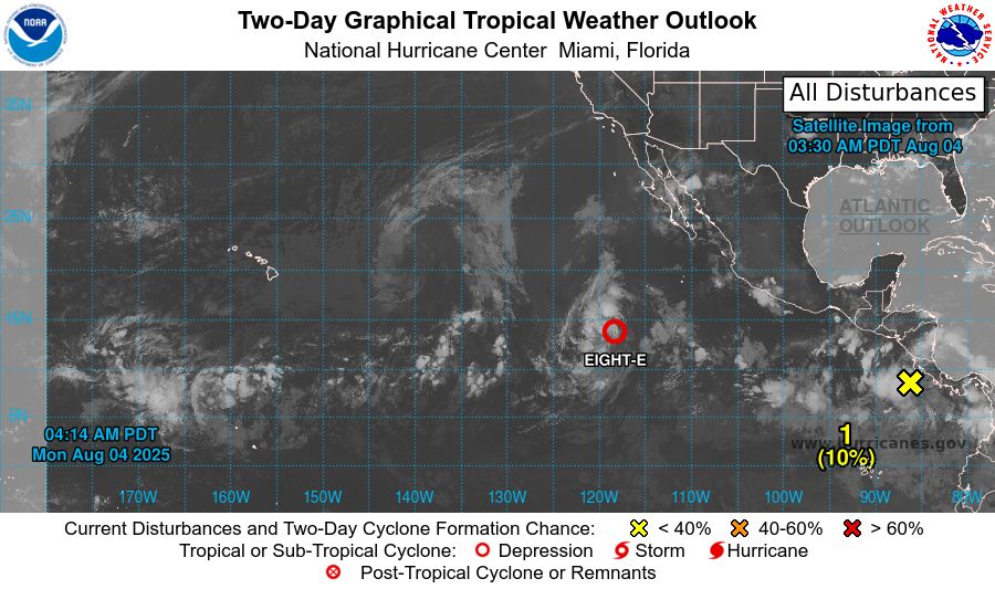
tropical weather outlook over the next 2 days greyscale satellite image of Eastern Pacific Ocean for
NWS National Hurricane Center Miami FL
1100 AM PDT Mon Aug 4 2025
For the eastern and central North Pacific east of 180 longitude:
Active Systems:
The National Hurricane Center is issuing advisories on Tropical
Depression Eight-E, located well southwest of the Baja California
Peninsula.
1. South of Southern Mexico:
An area low pressure just offshore of the coast of Central
America is producing disorganized showers and thunderstorms.
Environmental conditions appear conducive for development, and a
tropical depression is likely to form later this week while the
system moves generally west-northwestward at 10 to 15 mph.
* Formation chance through 48 hours...low...20 percent.
* Formation chance through 7 days...high...70 percent.
Public advisories on Tropical Depression Eight-E are issued under
WMO header WTPZ33 KNHC and under AWIPS header MIATCPEP3.
Forecast/Advisories on Tropical Depression Eight-E are issued under
WMO header WTPZ23 KNHC and under AWIPS header MIATCMEP3.
Forecaster Roberts
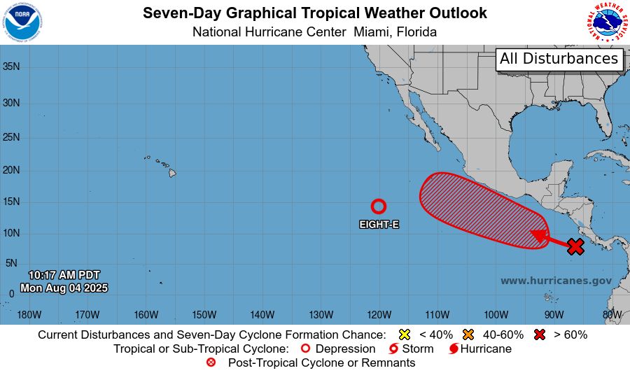
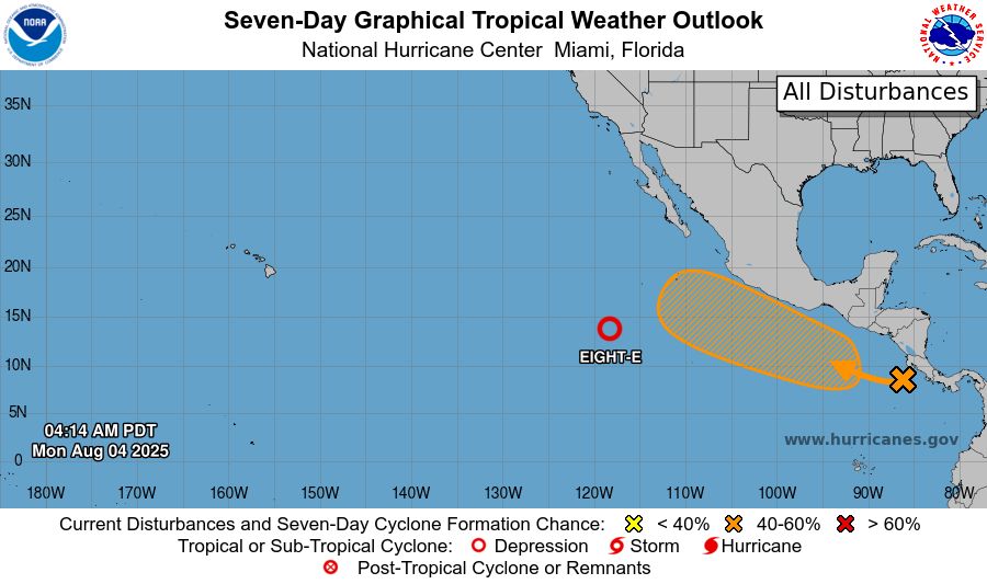
tropical weather outlook over the next 7 days color illustrated image of Eastern Pacific Ocean for
NWS National Hurricane Center Miami FL
1100 AM PDT Mon Aug 4 2025
For the eastern and central North Pacific east of 180 longitude:
Active Systems:
The National Hurricane Center is issuing advisories on Tropical
Depression Eight-E, located well southwest of the Baja California
Peninsula.
1. South of Southern Mexico:
An area low pressure just offshore of the coast of Central
America is producing disorganized showers and thunderstorms.
Environmental conditions appear conducive for development, and a
tropical depression is likely to form later this week while the
system moves generally west-northwestward at 10 to 15 mph.
* Formation chance through 48 hours...low...20 percent.
* Formation chance through 7 days...high...70 percent.
Public advisories on Tropical Depression Eight-E are issued under
WMO header WTPZ33 KNHC and under AWIPS header MIATCPEP3.
Forecast/Advisories on Tropical Depression Eight-E are issued under
WMO header WTPZ23 KNHC and under AWIPS header MIATCMEP3.
Forecaster Roberts
NWS National Hurricane Center Miami FL
1100 AM PDT Mon Aug 4 2025
For the eastern and central North Pacific east of 180 longitude:
Active Systems:
The National Hurricane Center is issuing advisories on Tropical
Depression Eight-E, located well southwest of the Baja California
Peninsula.
04.08.2025 18:12 — 👍 0 🔁 0 💬 0 📌 0
tropical weather outlook over the next 2 days greyscale satellite image of Eastern Pacific Ocean for
NWS National Hurricane Center Miami FL
500 AM PDT Mon Aug 4 2025
For the eastern and central North Pacific east of 180 longitude:
Active Systems:
The National Hurricane Center is issuing advisories on newly formed
Tropical Depression Eight-E, located well southwest of the Baja
California Peninsula.
1. South of Southern Mexico:
A trough of low pressure just offshore of the coast of Central
America is producing disorganized showers and thunderstorms.
Environmental conditions appear conducive for development, and a
tropical depression could form later this week while the system
moves generally west-northwestward at 10 to 15 mph.
* Formation chance through 48 hours...low...10 percent.
* Formation chance through 7 days...medium...60 percent.
Public advisories on Tropical Depression Eight-E are issued under
WMO header WTPZ33 KNHC and under AWIPS header MIATCPEP3.
Forecast/Advisories on Tropical Depression Eight-E are issued under
WMO header WTPZ23 KNHC and under AWIPS header MIATCMEP3.
Forecaster Gibbs
tropical weather outlook over the next 7 days color illustrated image of Eastern Pacific Ocean for
NWS National Hurricane Center Miami FL
500 AM PDT Mon Aug 4 2025
For the eastern and central North Pacific east of 180 longitude:
Active Systems:
The National Hurricane Center is issuing advisories on newly formed
Tropical Depression Eight-E, located well southwest of the Baja
California Peninsula.
1. South of Southern Mexico:
A trough of low pressure just offshore of the coast of Central
America is producing disorganized showers and thunderstorms.
Environmental conditions appear conducive for development, and a
tropical depression could form later this week while the system
moves generally west-northwestward at 10 to 15 mph.
* Formation chance through 48 hours...low...10 percent.
* Formation chance through 7 days...medium...60 percent.
Public advisories on Tropical Depression Eight-E are issued under
WMO header WTPZ33 KNHC and under AWIPS header MIATCPEP3.
Forecast/Advisories on Tropical Depression Eight-E are issued under
WMO header WTPZ23 KNHC and under AWIPS header MIATCMEP3.
Forecaster Gibbs
NWS National Hurricane Center Miami FL
500 AM PDT Mon Aug 4 2025
For the eastern and central North Pacific east of 180 longitude:
Active Systems:
The National Hurricane Center is issuing advisories on newly formed
Tropical Depression Eight-E, located well southwest of the Baja
California Penins
04.08.2025 12:15 — 👍 0 🔁 0 💬 0 📌 0
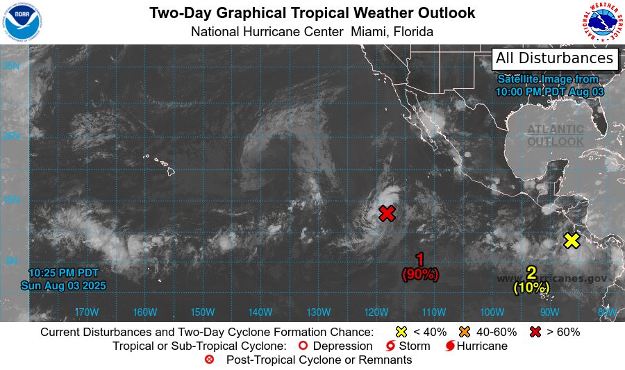
tropical weather outlook over the next 2 days greyscale satellite image of Eastern Pacific Ocean for
NWS National Hurricane Center Miami FL
1100 PM PDT Sun Aug 3 2025
For the eastern and central North Pacific east of 180 longitude:
1. Well Southwest of the Baja California Peninsula (EP90):
Showers and thunderstorms associated with a low pressure system
located well southwest of the southern tip of the Baja California
peninsula have become slightly better organized since yesterday.
Environmental conditions are conducive for additional development,
and a tropical depression is very likely to form during the next day
or so while the system moves west-northwestward at 10 to 15 mph.
For additional information, including gale warnings, please see High
Seas Forecasts issued by the National Weather Service.
* Formation chance through 48 hours...high...90 percent.
* Formation chance through 7 days...high...90 percent.
2. South of Southern Mexico:
A trough of low pressure just offshore of Central America is
producing disorganized showers and thunderstorms. Environmental
conditions appear conducive for further development, and a tropical
depression could form later this week while the system moves
generally west-northwestward at 10 to 15 mph.
* Formation chance through 48 hours...low...10 percent.
* Formation chance through 7 days...medium...50 percent.
High Seas Forecasts issued by the National Weather Service
can be found under AWIPS header NFDHSFEPI, WMO header FZPN02
KWBC, and on the web at ocean.weather.gov/shtml/NFDHSFEPI.php
Forecaster Gibbs
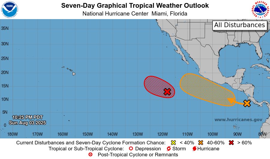
tropical weather outlook over the next 7 days color illustrated image of Eastern Pacific Ocean for
NWS National Hurricane Center Miami FL
1100 PM PDT Sun Aug 3 2025
For the eastern and central North Pacific east of 180 longitude:
1. Well Southwest of the Baja California Peninsula (EP90):
Showers and thunderstorms associated with a low pressure system
located well southwest of the southern tip of the Baja California
peninsula have become slightly better organized since yesterday.
Environmental conditions are conducive for additional development,
and a tropical depression is very likely to form during the next day
or so while the system moves west-northwestward at 10 to 15 mph.
For additional information, including gale warnings, please see High
Seas Forecasts issued by the National Weather Service.
* Formation chance through 48 hours...high...90 percent.
* Formation chance through 7 days...high...90 percent.
2. South of Southern Mexico:
A trough of low pressure just offshore of Central America is
producing disorganized showers and thunderstorms. Environmental
conditions appear conducive for further development, and a tropical
depression could form later this week while the system moves
generally west-northwestward at 10 to 15 mph.
* Formation chance through 48 hours...low...10 percent.
* Formation chance through 7 days...medium...50 percent.
High Seas Forecasts issued by the National Weather Service
can be found under AWIPS header NFDHSFEPI, WMO header FZPN02
KWBC, and on the web at ocean.weather.gov/shtml/NFDHSFEPI.php
Forecaster Gibbs
NWS National Hurricane Center Miami FL
1100 PM PDT Sun Aug 3 2025
For the eastern and central North Pacific east of 180 longitude:
04.08.2025 06:17 — 👍 0 🔁 0 💬 0 📌 0
tropical weather outlook over the next 2 days greyscale satellite image of Eastern Pacific Ocean for
NWS National Hurricane Center Miami FL
500 PM PDT Sun Aug 3 2025
For the eastern and central North Pacific east of 180 longitude:
1. Central East Pacific (EP90):
Disorganized showers and thunderstorms located well south-southwest
of the southern tip of the Baja California Peninsula are associated
with a broad area of low pressure. Environmental conditions are
conducive for development of this system, and a tropical depression
is very likely to form during the next day or two while the system
moves west-northwestward at 10 to 15 mph. For additional
information, including gale warnings, please see High Seas Forecasts
issued by the National Weather Service.
* Formation chance through 48 hours...high...90 percent.
* Formation chance through 7 days...high...90 percent.
2. South of Southern Mexico:
An area of low pressure is forecast to form offshore of the coast of
Central America and southern Mexico by midweek. Environmental
conditions appear conducive for some development, and a tropical
depression could form later this week as the system moves generally
west-northwestward at 10 to 15 mph.
* Formation chance through 48 hours...low...near 0 percent.
* Formation chance through 7 days...medium...50 percent.
High Seas Forecasts issued by the National Weather Service
can be found under AWIPS header NFDHSFEPI, WMO header FZPN02
KWBC, and on the web at ocean.weather.gov/shtml/NFDHSFEPI.php
Forecaster Pasch
tropical weather outlook over the next 7 days color illustrated image of Eastern Pacific Ocean for
NWS National Hurricane Center Miami FL
500 PM PDT Sun Aug 3 2025
For the eastern and central North Pacific east of 180 longitude:
1. Central East Pacific (EP90):
Disorganized showers and thunderstorms located well south-southwest
of the southern tip of the Baja California Peninsula are associated
with a broad area of low pressure. Environmental conditions are
conducive for development of this system, and a tropical depression
is very likely to form during the next day or two while the system
moves west-northwestward at 10 to 15 mph. For additional
information, including gale warnings, please see High Seas Forecasts
issued by the National Weather Service.
* Formation chance through 48 hours...high...90 percent.
* Formation chance through 7 days...high...90 percent.
2. South of Southern Mexico:
An area of low pressure is forecast to form offshore of the coast of
Central America and southern Mexico by midweek. Environmental
conditions appear conducive for some development, and a tropical
depression could form later this week as the system moves generally
west-northwestward at 10 to 15 mph.
* Formation chance through 48 hours...low...near 0 percent.
* Formation chance through 7 days...medium...50 percent.
High Seas Forecasts issued by the National Weather Service
can be found under AWIPS header NFDHSFEPI, WMO header FZPN02
KWBC, and on the web at ocean.weather.gov/shtml/NFDHSFEPI.php
Forecaster Pasch
NWS National Hurricane Center Miami FL
500 PM PDT Sun Aug 3 2025
For the eastern and central North Pacific east of 180 longitude:
04.08.2025 00:43 — 👍 0 🔁 0 💬 0 📌 0
tropical weather outlook over the next 2 days greyscale satellite image of Eastern Pacific Ocean for
NWS National Hurricane Center Miami FL
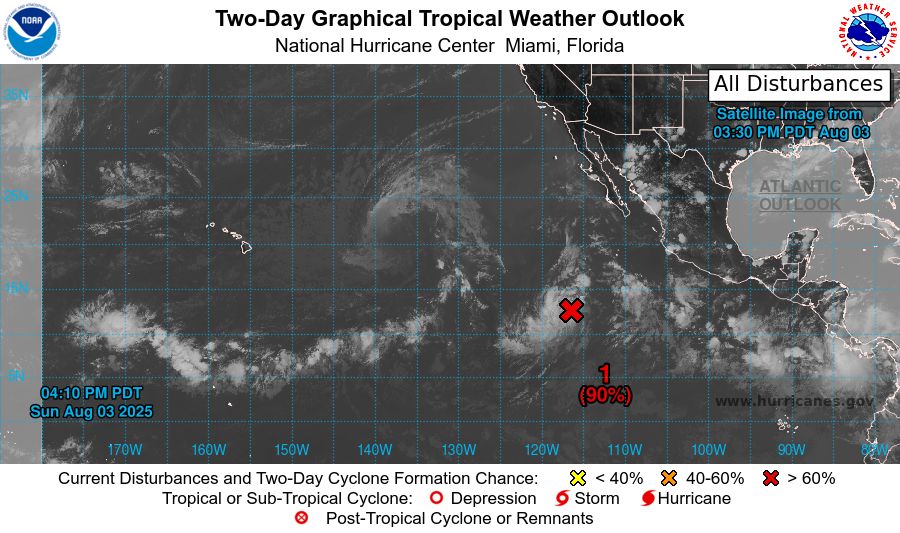
1100 AM PDT Sun Aug 3 2025
For the eastern and central North Pacific east of 180 longitude:
Active Systems:
The National Hurricane Center has issued the last advisory on
Post-Tropical Cyclone Gil, located well east of the Hawaiian
Islands.
1. Central East Pacific (EP90):
Disorganized showers and thunderstorms located well south-southwest
of the southern tip of the Baja California Peninsula are associated
with a broad area of low pressure. Environmental conditions are
conducive for development of this system, and a tropical depression
is very likely to form during the next day or two while the system
moves west-northwestward at 10 to 15 mph. For additional
information, including gale warnings, please see High Seas
Forecasts issued by the National Weather Service.
* Formation chance through 48 hours...high...90 percent.
* Formation chance through 7 days...high...90 percent.
2. South of Southern Mexico:
An area of low pressure is forecast to form offshore of the coast of
Central America and southern Mexico by midweek. Environmental
conditions appear conducive for some development, and a tropical
depression could form later this week as the system moves generally
west-northwestward at 10 to 15 mph.
* Formation chance through 48 hours...low...near 0 percent.
* Formation chance through 7 days...medium...50 percent.
High Seas Forecasts issued by the National Weather Service
can be found under AWIPS header NFDHSFEPI, WMO header FZPN02
KWBC, and on the web at ocean.weather.gov/shtml/NFDHSFEPI.php
Forecaster Bucci/Rosado-Vazquez

tropical weather outlook over the next 7 days color illustrated image of Eastern Pacific Ocean for
NWS National Hurricane Center Miami FL
1100 AM PDT Sun Aug 3 2025
For the eastern and central North Pacific east of 180 longitude:
Active Systems:
The National Hurricane Center has issued the last advisory on
Post-Tropical Cyclone Gil, located well east of the Hawaiian
Islands.
1. Central East Pacific (EP90):
Disorganized showers and thunderstorms located well south-southwest
of the southern tip of the Baja California Peninsula are associated
with a broad area of low pressure. Environmental conditions are
conducive for development of this system, and a tropical depression
is very likely to form during the next day or two while the system
moves west-northwestward at 10 to 15 mph. For additional
information, including gale warnings, please see High Seas
Forecasts issued by the National Weather Service.
* Formation chance through 48 hours...high...90 percent.
* Formation chance through 7 days...high...90 percent.
2. South of Southern Mexico:
An area of low pressure is forecast to form offshore of the coast of
Central America and southern Mexico by midweek. Environmental
conditions appear conducive for some development, and a tropical
depression could form later this week as the system moves generally
west-northwestward at 10 to 15 mph.
* Formation chance through 48 hours...low...near 0 percent.
* Formation chance through 7 days...medium...50 percent.
High Seas Forecasts issued by the National Weather Service
can be found under AWIPS header NFDHSFEPI, WMO header FZPN02
KWBC, and on the web at ocean.weather.gov/shtml/NFDHSFEPI.php
Forecaster Bucci/Rosado-Vazquez
NWS National Hurricane Center Miami FL
1100 AM PDT Sun Aug 3 2025
For the eastern and central North Pacific east of 180 longitude:
Active Systems:
The National Hurricane Center has issued the last advisory on
Post-Tropical Cyclone Gil, located well east of the Hawaiian
Islands.
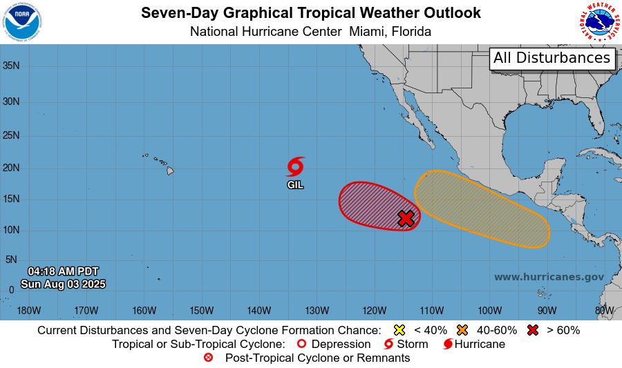
03.08.2025 18:10 — 👍 1 🔁 0 💬 0 📌 0
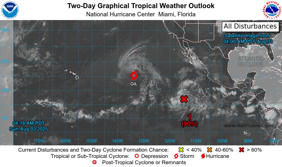
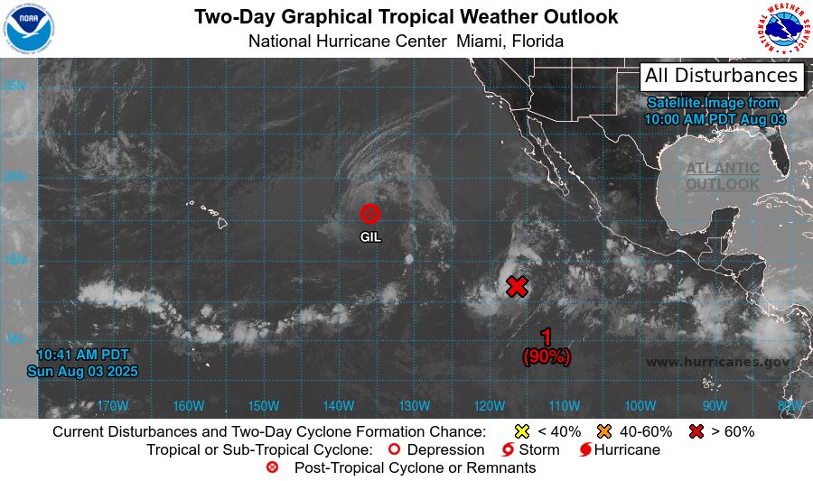
tropical weather outlook over the next 2 days greyscale satellite image of Eastern Pacific Ocean for
NWS National Hurricane Center Miami FL
500 AM PDT Sun Aug 3 2025
For the eastern and central North Pacific east of 180 longitude:
Active Systems:
The National Hurricane Center is issuing advisories on Tropical
Storm Gil, located well east of the Hawaiian Islands.
1. Central East Pacific (EP90):
Disorganized showers and thunderstorms located well west-southwest
of the southwestern coast of Mexico are associated with a broad area
of low pressure. Environmental conditions are conducive for
development of this system, and a tropical depression is likely to
form during the next day or two while the system moves
west-northwestward at 10 to 15 mph. For additional information,
including gale warnings, please see High Seas Forecasts issued by
the National Weather Service.
* Formation chance through 48 hours...high...90 percent.
* Formation chance through 7 days...high...90 percent.
2. South of Southern Mexico:
An area of low pressure is forecast to form offshore of the coast of
Central America and southern Mexico by midweek. Environmental
conditions appear conducive for some development, and a tropical
depression could form later this week as the system moves generally
west-northwestward at 10 to 15 mph.
* Formation chance through 48 hours...low...near 0 percent.
* Formation chance through 7 days...medium...50 percent.
High Seas Forecasts issued by the National Weather Service
can be found under AWIPS header NFDHSFEPI, WMO header FZPN02
KWBC, and on the web at ocean.weather.gov/shtml/NFDHSFEPI.php
Forecaster Gibbs
tropical weather outlook over the next 7 days color illustrated image of Eastern Pacific Ocean for
NWS National Hurricane Center Miami FL
500 AM PDT Sun Aug 3 2025
For the eastern and central North Pacific east of 180 longitude:
Active Systems:
The National Hurricane Center is issuing advisories on Tropical
Storm Gil, located well east of the Hawaiian Islands.
1. Central East Pacific (EP90):
Disorganized showers and thunderstorms located well west-southwest
of the southwestern coast of Mexico are associated with a broad area
of low pressure. Environmental conditions are conducive for
development of this system, and a tropical depression is likely to
form during the next day or two while the system moves
west-northwestward at 10 to 15 mph. For additional information,
including gale warnings, please see High Seas Forecasts issued by
the National Weather Service.
* Formation chance through 48 hours...high...90 percent.
* Formation chance through 7 days...high...90 percent.
2. South of Southern Mexico:
An area of low pressure is forecast to form offshore of the coast of
Central America and southern Mexico by midweek. Environmental
conditions appear conducive for some development, and a tropical
depression could form later this week as the system moves generally
west-northwestward at 10 to 15 mph.
* Formation chance through 48 hours...low...near 0 percent.
* Formation chance through 7 days...medium...50 percent.
High Seas Forecasts issued by the National Weather Service
can be found under AWIPS header NFDHSFEPI, WMO header FZPN02
KWBC, and on the web at ocean.weather.gov/shtml/NFDHSFEPI.php
Forecaster Gibbs
NWS National Hurricane Center Miami FL
500 AM PDT Sun Aug 3 2025
For the eastern and central North Pacific east of 180 longitude:
Active Systems:
The National Hurricane Center is issuing advisories on Tropical
Storm Gil, located well east of the Hawaiian Islands.
03.08.2025 12:13 — 👍 0 🔁 0 💬 0 📌 0
tropical weather outlook over the next 2 days greyscale satellite image of Eastern Pacific Ocean for
NWS National Hurricane Center Miami FL
1100 PM PDT Sat Aug 2 2025
For the eastern and central North Pacific east of 180 longitude:
Active Systems:
The National Hurricane Center is issuing advisories on Tropical
Storm Gil, located well east of the Hawaiian Islands.
1. Central East Pacific (EP90):
Disorganized showers and thunderstorms located well west-southwest
of the southwestern coast of Mexico are associated with a broad area
of low pressure. Environmental conditions are conducive for
development of this system, and a tropical depression is expected to
form late this weekend or early next week while the system moves
west-northwestward at 10 to 15 mph.
* Formation chance through 48 hours...high...80 percent.
* Formation chance through 7 days...high...90 percent.
2. South of Southern Mexico:
An area of low pressure is forecast to form offshore of the coast of
Central America and southern Mexico by the middle part of next week.
Environmental conditions appear conducive for some development, and
a tropical depression could form late next week as the system moves
generally west-northwestward at 10 to 15 mph.
* Formation chance through 48 hours...low...near 0 percent.
* Formation chance through 7 days...medium...50 percent.
Forecaster Gibbs

tropical weather outlook over the next 7 days color illustrated image of Eastern Pacific Ocean for
NWS National Hurricane Center Miami FL
1100 PM PDT Sat Aug 2 2025
For the eastern and central North Pacific east of 180 longitude:
Active Systems:
The National Hurricane Center is issuing advisories on Tropical
Storm Gil, located well east of the Hawaiian Islands.
1. Central East Pacific (EP90):
Disorganized showers and thunderstorms located well west-southwest
of the southwestern coast of Mexico are associated with a broad area
of low pressure. Environmental conditions are conducive for
development of this system, and a tropical depression is expected to
form late this weekend or early next week while the system moves
west-northwestward at 10 to 15 mph.
* Formation chance through 48 hours...high...80 percent.
* Formation chance through 7 days...high...90 percent.
2. South of Southern Mexico:
An area of low pressure is forecast to form offshore of the coast of
Central America and southern Mexico by the middle part of next week.
Environmental conditions appear conducive for some development, and
a tropical depression could form late next week as the system moves
generally west-northwestward at 10 to 15 mph.
* Formation chance through 48 hours...low...near 0 percent.
* Formation chance through 7 days...medium...50 percent.
Forecaster Gibbs
NWS National Hurricane Center Miami FL
1100 PM PDT Sat Aug 2 2025
For the eastern and central North Pacific east of 180 longitude:
Active Systems:
The National Hurricane Center is issuing advisories on Tropical
Storm Gil, located well east of the Hawaiian Islands.
03.08.2025 06:12 — 👍 0 🔁 0 💬 0 📌 0
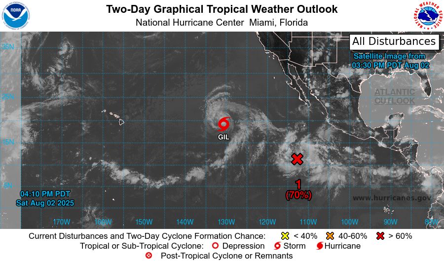
tropical weather outlook over the next 2 days greyscale satellite image of Eastern Pacific Ocean for
NWS National Hurricane Center Miami FL
500 PM PDT Sat Aug 2 2025
For the eastern and central North Pacific east of 180 longitude:
Active Systems:
The National Hurricane Center is issuing advisories on Tropical
Storm Gil, located well west of the southern tip of the Baja
California peninsula.
1. Central East Pacific (EP90):
Disorganized showers and thunderstorms located well southwest of the
southwestern coast of Mexico are associated with a broad area of
low pressure. Environmental conditions are conducive for
development of this system, and a tropical depression is expected
to form late this weekend or early next week while the system moves
west-northwestward at 10 to 15 mph.
* Formation chance through 48 hours...high...70 percent.
* Formation chance through 7 days...high...90 percent.
2. South of Southern Mexico:
An area of low pressure is forecast to form offshore of the coast of
Central America and southern Mexico by the middle part of next week.
Environmental conditions appear conducive for some development, and
a tropical depression could form late next week as the system moves
generally west-northwestward at 10 to 15 mph.
* Formation chance through 48 hours...low...near 0 percent.
* Formation chance through 7 days...medium...40 percent.
Forecaster Berg
tropical weather outlook over the next 7 days color illustrated image of Eastern Pacific Ocean for
NWS National Hurricane Center Miami FL
500 PM PDT Sat Aug 2 2025
For the eastern and central North Pacific east of 180 longitude:
Active Systems:
The National Hurricane Center is issuing advisories on Tropical
Storm Gil, located well west of the southern tip of the Baja
California peninsula.
1. Central East Pacific (EP90):
Disorganized showers and thunderstorms located well southwest of the
southwestern coast of Mexico are associated with a broad area of
low pressure. Environmental conditions are conducive for
development of this system, and a tropical depression is expected
to form late this weekend or early next week while the system moves
west-northwestward at 10 to 15 mph.
* Formation chance through 48 hours...high...70 percent.
* Formation chance through 7 days...high...90 percent.
2. South of Southern Mexico:
An area of low pressure is forecast to form offshore of the coast of
Central America and southern Mexico by the middle part of next week.
Environmental conditions appear conducive for some development, and
a tropical depression could form late next week as the system moves
generally west-northwestward at 10 to 15 mph.
* Formation chance through 48 hours...low...near 0 percent.
* Formation chance through 7 days...medium...40 percent.
Forecaster Berg
NWS National Hurricane Center Miami FL
500 PM PDT Sat Aug 2 2025
For the eastern and central North Pacific east of 180 longitude:
Active Systems:
The National Hurricane Center is issuing advisories on Tropical
Storm Gil, located well west of the southern tip of the Baja
California peninsula.
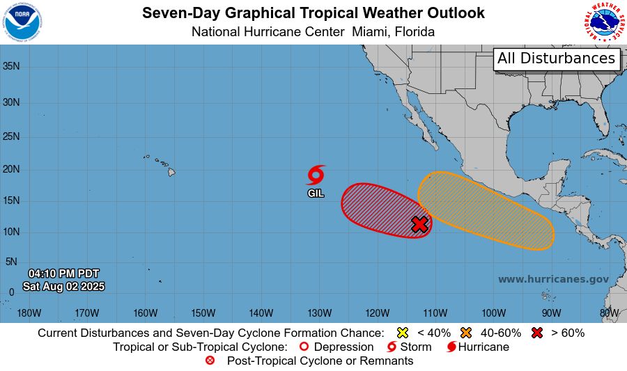
03.08.2025 00:44 — 👍 1 🔁 0 💬 0 📌 0
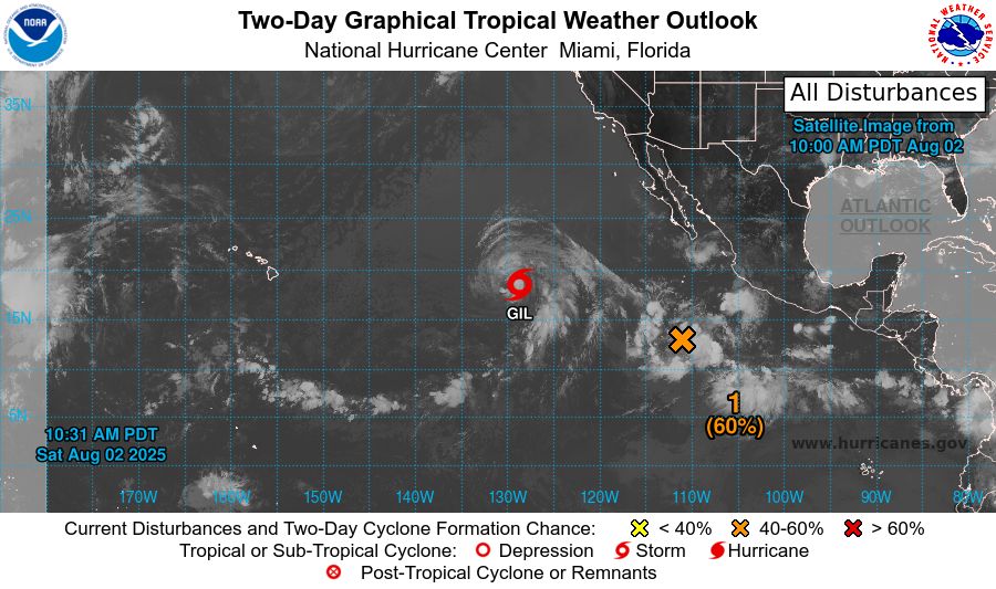
tropical weather outlook over the next 2 days greyscale satellite image of Eastern Pacific Ocean for
NWS National Hurricane Center Miami FL
1100 AM PDT Sat Aug 2 2025
For the eastern and central North Pacific east of 180 longitude:
Active Systems:
The National Hurricane Center is issuing advisories on
recently-downgraded Tropical Storm Gil, located well
west-southwest of the southern Baja California peninsula.
1. Central East Pacific:
An area of low pressure is expected to form well southwest of
southwestern Mexico within the next day or so. Environmental
conditions appear conducive for some gradual development of this
system, and a tropical depression is likely to form late this
weekend or early next week as the system moves west-northwestward
at 10 to 15 mph.
* Formation chance through 48 hours...medium...60 percent.
* Formation chance through 7 days...high...80 percent.
2. South of Southern Mexico:
An area of low pressure is forecast to form offshore of the coast of
Central America and southern Mexico by the middle part of next week.
Environmental conditions appear conducive for some development, and
a tropical depression could form late next week as the system moves
generally west-northwestward at 10 to 15 mph.
* Formation chance through 48 hours...low...near 0 percent.
* Formation chance through 7 days...medium...40 percent.
Forecaster Hogsett

tropical weather outlook over the next 7 days color illustrated image of Eastern Pacific Ocean for
NWS National Hurricane Center Miami FL
1100 AM PDT Sat Aug 2 2025
For the eastern and central North Pacific east of 180 longitude:
Active Systems:
The National Hurricane Center is issuing advisories on
recently-downgraded Tropical Storm Gil, located well
west-southwest of the southern Baja California peninsula.
1. Central East Pacific:
An area of low pressure is expected to form well southwest of
southwestern Mexico within the next day or so. Environmental
conditions appear conducive for some gradual development of this
system, and a tropical depression is likely to form late this
weekend or early next week as the system moves west-northwestward
at 10 to 15 mph.
* Formation chance through 48 hours...medium...60 percent.
* Formation chance through 7 days...high...80 percent.
2. South of Southern Mexico:
An area of low pressure is forecast to form offshore of the coast of
Central America and southern Mexico by the middle part of next week.
Environmental conditions appear conducive for some development, and
a tropical depression could form late next week as the system moves
generally west-northwestward at 10 to 15 mph.
* Formation chance through 48 hours...low...near 0 percent.
* Formation chance through 7 days...medium...40 percent.
Forecaster Hogsett
NWS National Hurricane Center Miami FL
1100 AM PDT Sat Aug 2 2025
For the eastern and central North Pacific east of 180 longitude:
Active Systems:
The National Hurricane Center is issuing advisories on
recently-downgraded Tropical Storm Gil, located well
west-southwest of the southern Baja Cali
02.08.2025 18:10 — 👍 0 🔁 1 💬 0 📌 0
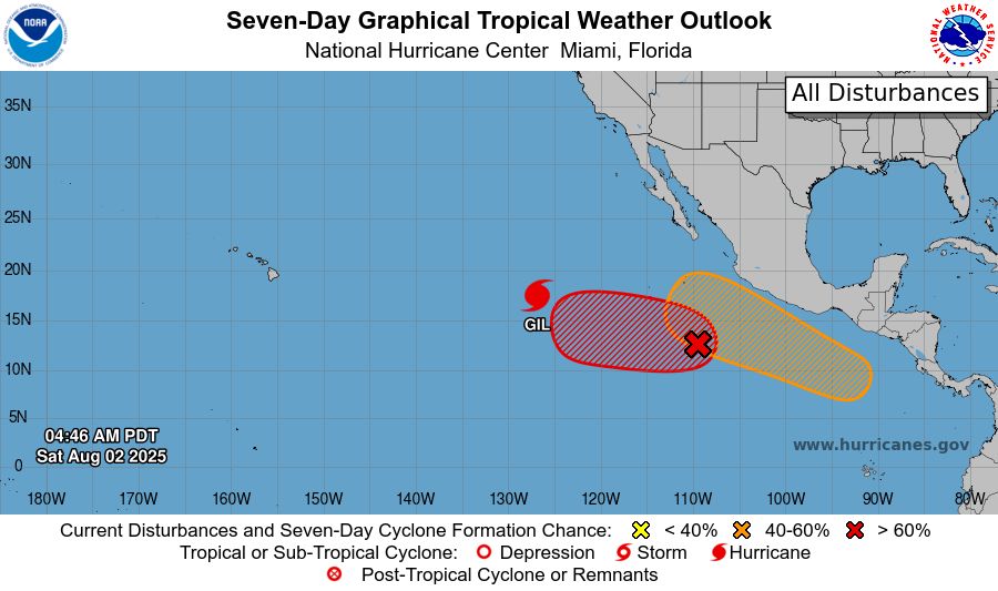
tropical weather outlook over the next 2 days greyscale satellite image of Eastern Pacific Ocean for
NWS National Hurricane Center Miami FL
500 AM PDT Sat Aug 2 2025
For the eastern and central North Pacific east of 180 longitude:
Active Systems:
The National Hurricane Center is issuing advisories on Hurricane
Gil, located well west-southwest of the southern Baja California
peninsula.
1. Central East Pacific:
An area of low pressure is expected to form well southwest of
southwestern Mexico within the next day or two. Environmental
conditions appear conducive for some gradual development of this
system, and a tropical depression is likely to form late this
weekend or early next week as the system moves west-northwestward at
10 to 15 mph.
* Formation chance through 48 hours...medium...50 percent.
* Formation chance through 7 days...high...80 percent.
2. South of Southern Mexico:
An area of low pressure is forecast to form offshore of the coast of
Central America and southern Mexico by the middle part of next week.
Thereafter, environmental conditions appear conducive for some
development, and a tropical depression could form late next week as
the system moves generally west-northwestward at 10 to 15 mph.
* Formation chance through 48 hours...low...near 0 percent.
* Formation chance through 7 days...medium...40 percent.
Forecaster Hogsett
tropical weather outlook over the next 7 days color illustrated image of Eastern Pacific Ocean for
NWS National Hurricane Center Miami FL
500 AM PDT Sat Aug 2 2025
For the eastern and central North Pacific east of 180 longitude:
Active Systems:
The National Hurricane Center is issuing advisories on Hurricane
Gil, located well west-southwest of the southern Baja California
peninsula.
1. Central East Pacific:
An area of low pressure is expected to form well southwest of
southwestern Mexico within the next day or two. Environmental
conditions appear conducive for some gradual development of this
system, and a tropical depression is likely to form late this
weekend or early next week as the system moves west-northwestward at
10 to 15 mph.
* Formation chance through 48 hours...medium...50 percent.
* Formation chance through 7 days...high...80 percent.
2. South of Southern Mexico:
An area of low pressure is forecast to form offshore of the coast of
Central America and southern Mexico by the middle part of next week.
Thereafter, environmental conditions appear conducive for some
development, and a tropical depression could form late next week as
the system moves generally west-northwestward at 10 to 15 mph.
* Formation chance through 48 hours...low...near 0 percent.
* Formation chance through 7 days...medium...40 percent.
Forecaster Hogsett
NWS National Hurricane Center Miami FL
500 AM PDT Sat Aug 2 2025
For the eastern and central North Pacific east of 180 longitude:
Active Systems:
The National Hurricane Center is issuing advisories on Hurricane
Gil, located well west-southwest of the southern Baja California
peninsula.
02.08.2025 12:13 — 👍 1 🔁 1 💬 0 📌 0
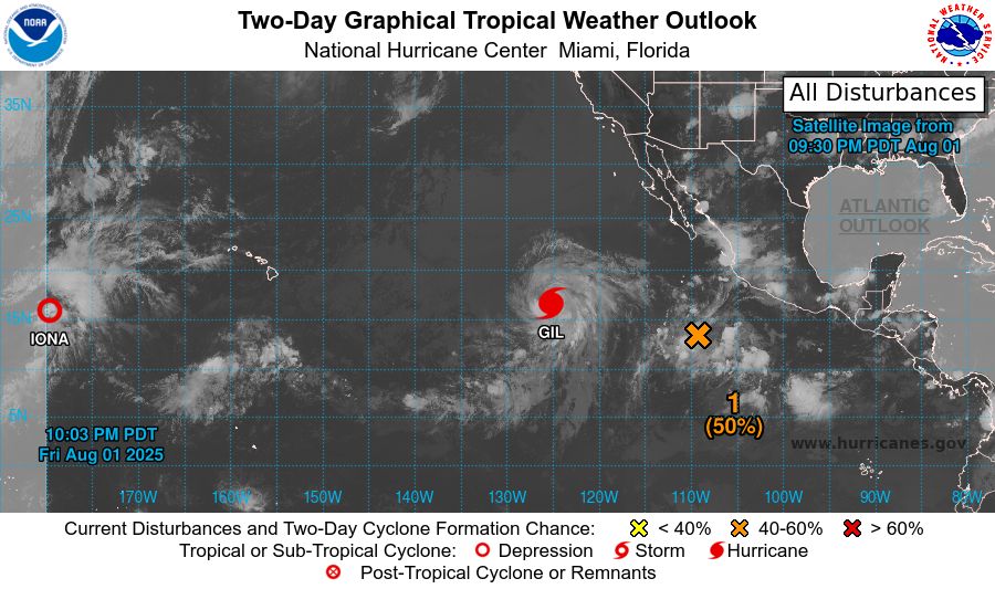
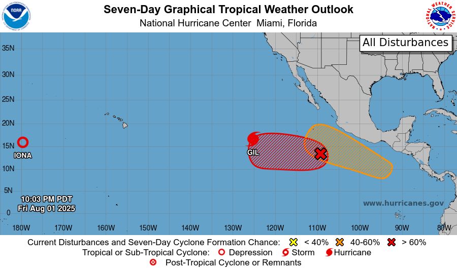
tropical weather outlook over the next 2 days greyscale satellite image of Eastern Pacific Ocean for
NWS National Hurricane Center Miami FL
1100 PM PDT Fri Aug 1 2025
For the eastern and central North Pacific east of 180 longitude:
Active Systems:
The National Hurricane Center is issuing advisories on Hurricane
Gil, located well west-southwest of the southern Baja California
peninsula. The Central Pacific Hurricane Center has issued its final
advisory on Tropical Depression Iona, which is now located west of
the International Date Line, well west-southwest of the Hawaiian
Islands. Future advisories will be issued by RSMC Tokyo, Japan. For
U.S. interests, refer to Department of Defense warnings issued by
the Joint Typhoon Warning Center in Honolulu, Hawaii.
1. Western East Pacific:
An area of low pressure is expected to form well southwest of
southwestern Mexico within the next day or two. Environmental
conditions appear conducive for some gradual development of this
system, and a tropical depression is likely to form late this
weekend or early next week as the system moves west-northwestward at
10 to 15 mph.
* Formation chance through 48 hours...medium...50 percent.
* Formation chance through 7 days...high...80 percent.
2. South of Southern Mexico:
An area of low pressure is forecast to form offshore of the coast of
Central America and southern Mexico by the middle part of next week.
Thereafter, environmental conditions appear conducive for some
development, and a tropical depression could form late next week as
the system moves generally west-northwestward at 10 to 15 mph.
* Formation chance through 48 hours...low...near 0 percent.
* Formation chance through 7 days...medium...40 percent.
Forecaster Gibbs
tropical weather outlook over the next 7 days color illustrated image of Eastern Pacific Ocean for
NWS National Hurricane Center Miami FL
1100 PM PDT Fri Aug 1 2025
For the eastern and central North Pacific east of 180 longitude:
Active Systems:
The National Hurricane Center is issuing advisories on Hurricane
Gil, located well west-southwest of the southern Baja California
peninsula. The Central Pacific Hurricane Center has issued its final
advisory on Tropical Depression Iona, which is now located west of
the International Date Line, well west-southwest of the Hawaiian
Islands. Future advisories will be issued by RSMC Tokyo, Japan. For
U.S. interests, refer to Department of Defense warnings issued by
the Joint Typhoon Warning Center in Honolulu, Hawaii.
1. Western East Pacific:
An area of low pressure is expected to form well southwest of
southwestern Mexico within the next day or two. Environmental
conditions appear conducive for some gradual development of this
system, and a tropical depression is likely to form late this
weekend or early next week as the system moves west-northwestward at
10 to 15 mph.
* Formation chance through 48 hours...medium...50 percent.
* Formation chance through 7 days...high...80 percent.
2. South of Southern Mexico:
An area of low pressure is forecast to form offshore of the coast of
Central America and southern Mexico by the middle part of next week.
Thereafter, environmental conditions appear conducive for some
development, and a tropical depression could form late next week as
the system moves generally west-northwestward at 10 to 15 mph.
* Formation chance through 48 hours...low...near 0 percent.
* Formation chance through 7 days...medium...40 percent.
Forecaster Gibbs
NWS National Hurricane Center Miami FL
1100 PM PDT Fri Aug 1 2025
For the eastern and central North Pacific east of 180 longitude:
Active Systems:
The National Hurricane Center is issuing advisories on Hurricane
Gil, located well west-southwest of the southern Baja California
peninsula. The Cen
02.08.2025 06:11 — 👍 0 🔁 0 💬 0 📌 0
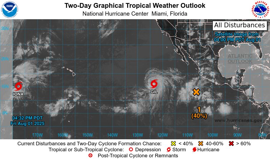
tropical weather outlook over the next 2 days greyscale satellite image of Eastern Pacific Ocean for
NWS National Hurricane Center Miami FL
500 PM PDT Fri Aug 1 2025
For the eastern and central North Pacific east of 180 longitude:
Active Systems:
The National Hurricane Center is issuing advisories on Tropical
Storm Iona, located in the central Pacific basin well west-southwest
of the Hawaiian Islands, and Tropical Storm Gil, located well
west-southwest of the southern Baja California peninsula.
1. Central East Pacific:
An area of low pressure is expected to form well southwest of
southwestern Mexico within the next day or two. Environmental
conditions appear conducive for some gradual development of this
system, and a tropical depression is likely to form late this
weekend or early next week as the system moves west-northwestward at
10 to 15 mph.
* Formation chance through 48 hours...medium...40 percent.
* Formation chance through 7 days...high...80 percent.
2. South of Southern Mexico:
An area of low pressure is forecast to form offshore of the coast of
Central America and southern Mexico by the middle part of next week.
Thereafter, environmental conditions appear conducive for some
development as the system moves generally west-northwestward at 10
to 15 mph.
* Formation chance through 48 hours...low...near 0 percent.
* Formation chance through 7 days...low...30 percent.
Forecaster Gibbs

tropical weather outlook over the next 7 days color illustrated image of Eastern Pacific Ocean for
NWS National Hurricane Center Miami FL
500 PM PDT Fri Aug 1 2025
For the eastern and central North Pacific east of 180 longitude:
Active Systems:
The National Hurricane Center is issuing advisories on Tropical
Storm Iona, located in the central Pacific basin well west-southwest
of the Hawaiian Islands, and Tropical Storm Gil, located well
west-southwest of the southern Baja California peninsula.
1. Central East Pacific:
An area of low pressure is expected to form well southwest of
southwestern Mexico within the next day or two. Environmental
conditions appear conducive for some gradual development of this
system, and a tropical depression is likely to form late this
weekend or early next week as the system moves west-northwestward at
10 to 15 mph.
* Formation chance through 48 hours...medium...40 percent.
* Formation chance through 7 days...high...80 percent.
2. South of Southern Mexico:
An area of low pressure is forecast to form offshore of the coast of
Central America and southern Mexico by the middle part of next week.
Thereafter, environmental conditions appear conducive for some
development as the system moves generally west-northwestward at 10
to 15 mph.
* Formation chance through 48 hours...low...near 0 percent.
* Formation chance through 7 days...low...30 percent.
Forecaster Gibbs
NWS National Hurricane Center Miami FL
500 PM PDT Fri Aug 1 2025
For the eastern and central North Pacific east of 180 longitude:
Active Systems:
The National Hurricane Center is issuing advisories on Tropical
Storm Iona, located in the central Pacific basin well west-southwest
of the Hawaiian
02.08.2025 00:37 — 👍 0 🔁 0 💬 0 📌 0
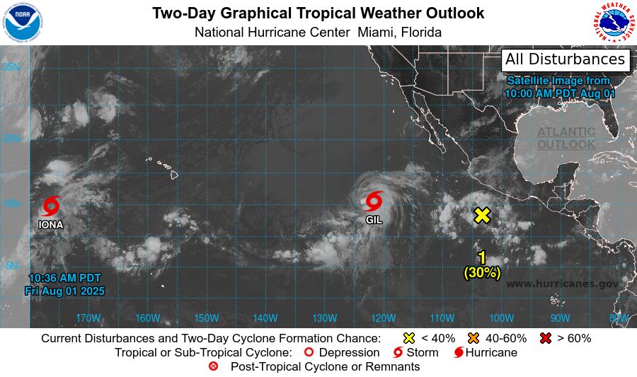
tropical weather outlook over the next 2 days greyscale satellite image of Eastern Pacific Ocean for
NWS National Hurricane Center Miami FL
1100 AM PDT Fri Aug 1 2025
For the eastern and central North Pacific east of 180 longitude:
Active Systems:
The National Hurricane Center is issuing advisories on Tropical
Storm Iona, located in the central Pacific basin well west-southwest
of the Hawaiian Islands and Tropical Storm Gil, located well
west-southwest of the southern Baja California peninsula.
1. Central East Pacific:
An area of low pressure is expected to form well southwest of
southwestern Mexico within the next day or two. Environmental
conditions appear conducive for some gradual development of this
system, and a tropical depression is likely to form late this
weekend or early next week as the system moves west-northwestward at
10 to 15 mph.
* Formation chance through 48 hours...low...30 percent.
* Formation chance through 7 days...high...80 percent.
2. South of Southern Mexico:
An area of low pressure is forecast to form offshore of the coast of
Central America and southern Mexico by the middle part of next week.
Thereafter, environmental conditions appear conducive for some
development as the system moves generally west-northwestward at 10
to 15 mph.
* Formation chance through 48 hours...low...near 0 percent.
* Formation chance through 7 days...low...30 percent.
Forecaster Bucci

tropical weather outlook over the next 7 days color illustrated image of Eastern Pacific Ocean for
NWS National Hurricane Center Miami FL
1100 AM PDT Fri Aug 1 2025
For the eastern and central North Pacific east of 180 longitude:
Active Systems:
The National Hurricane Center is issuing advisories on Tropical
Storm Iona, located in the central Pacific basin well west-southwest
of the Hawaiian Islands and Tropical Storm Gil, located well
west-southwest of the southern Baja California peninsula.
1. Central East Pacific:
An area of low pressure is expected to form well southwest of
southwestern Mexico within the next day or two. Environmental
conditions appear conducive for some gradual development of this
system, and a tropical depression is likely to form late this
weekend or early next week as the system moves west-northwestward at
10 to 15 mph.
* Formation chance through 48 hours...low...30 percent.
* Formation chance through 7 days...high...80 percent.
2. South of Southern Mexico:
An area of low pressure is forecast to form offshore of the coast of
Central America and southern Mexico by the middle part of next week.
Thereafter, environmental conditions appear conducive for some
development as the system moves generally west-northwestward at 10
to 15 mph.
* Formation chance through 48 hours...low...near 0 percent.
* Formation chance through 7 days...low...30 percent.
Forecaster Bucci
NWS National Hurricane Center Miami FL
1100 AM PDT Fri Aug 1 2025
For the eastern and central North Pacific east of 180 longitude:
Active Systems:
The National Hurricane Center is issuing advisories on Tropical
Storm Iona, located in the central Pacific basin well west-southwest
of the Hawaiian
01.08.2025 18:11 — 👍 0 🔁 0 💬 0 📌 0
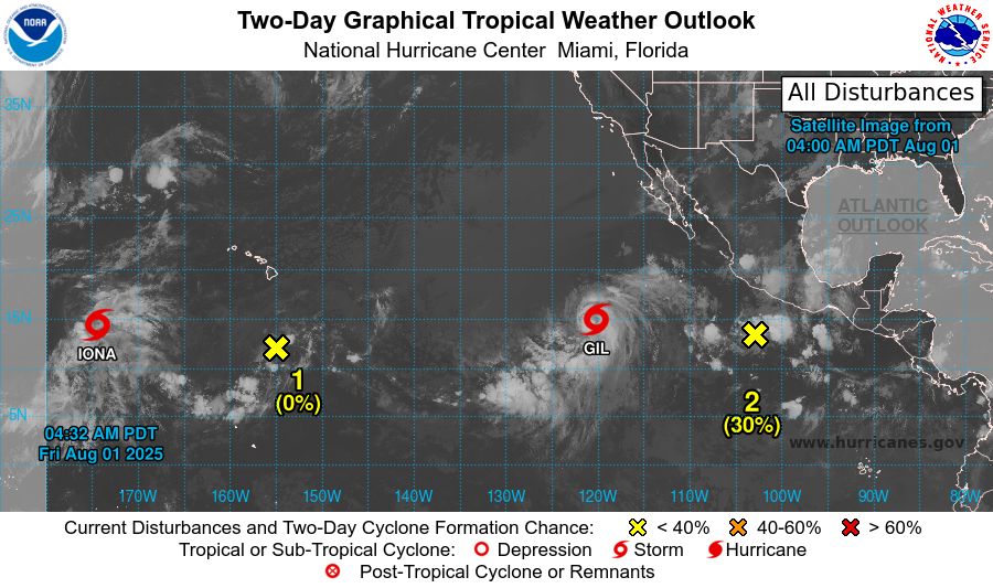
tropical weather outlook over the next 2 days greyscale satellite image of Eastern Pacific Ocean for
NWS National Hurricane Center Miami FL
500 AM PDT Fri Aug 1 2025
For the eastern and central North Pacific east of 180 longitude:
Active Systems:
The National Hurricane Center is issuing advisories on Tropical
Storm Iona, located in the central Pacific basin well west-southwest
of the Hawaiian Islands and Tropical Storm Gil, located well
southwest of the southern Baja California peninsula.
1. Well South-Southeast of the Hawaiian Islands (CP92):
Disorganized showers and thunderstorms are associated with a trough
of low pressure located well south-southeast of Hilo, Hawaii.
Environmental conditions are becoming increasingly unfavorable, and
development is no longer anticipated.
* Formation chance through 48 hours...low...near 0 percent.
* Formation chance through 7 days...low...near 0 percent.
2. Central East Pacific:
An area of low pressure is expected to form well southwest of
southwestern Mexico within the next day or two. Environmental
conditions appear conducive for some gradual development of this
system, and a tropical depression is likely to form late this
weekend or early next week as the system moves west-northwestward at
10 to 15 mph.
* Formation chance through 48 hours...low...30 percent.
* Formation chance through 7 days...high...80 percent.
3. South of Southern Mexico:
An area of low pressure is forecast to form offshore of the coast of
Central America and southern Mexico by the middle part of next week.
Thereafter, environmental conditions appear conducive for some
development as the system moves generally west-northwestward at 10
to 15 mph.
* Formation chance through 48 hours...low...near 0 percent.
* Formation chance through 7 days...low...20 percent.
Forecaster Bucci
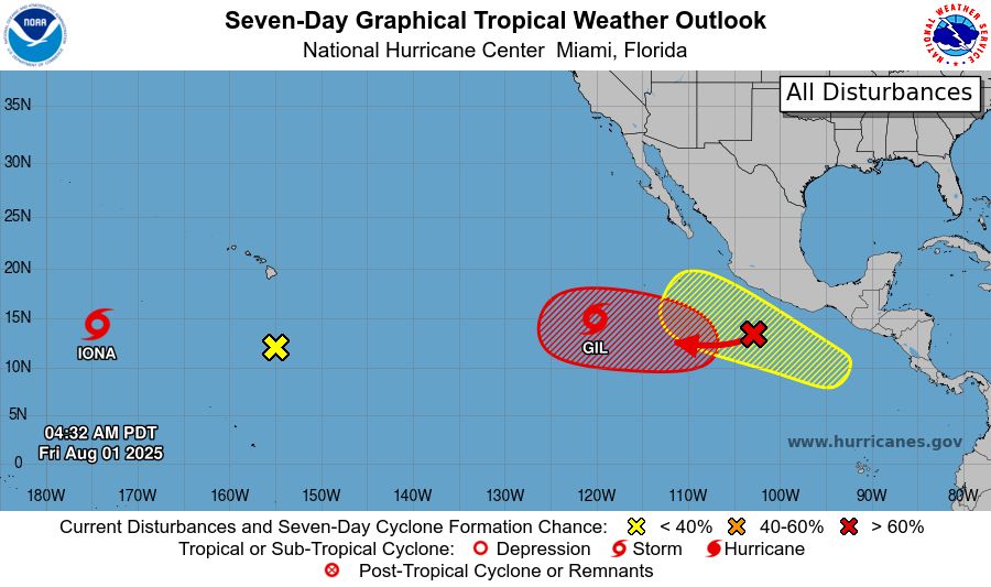
tropical weather outlook over the next 7 days color illustrated image of Eastern Pacific Ocean for
NWS National Hurricane Center Miami FL
500 AM PDT Fri Aug 1 2025
For the eastern and central North Pacific east of 180 longitude:
Active Systems:
The National Hurricane Center is issuing advisories on Tropical
Storm Iona, located in the central Pacific basin well west-southwest
of the Hawaiian Islands and Tropical Storm Gil, located well
southwest of the southern Baja California peninsula.
1. Well South-Southeast of the Hawaiian Islands (CP92):
Disorganized showers and thunderstorms are associated with a trough
of low pressure located well south-southeast of Hilo, Hawaii.
Environmental conditions are becoming increasingly unfavorable, and
development is no longer anticipated.
* Formation chance through 48 hours...low...near 0 percent.
* Formation chance through 7 days...low...near 0 percent.
2. Central East Pacific:
An area of low pressure is expected to form well southwest of
southwestern Mexico within the next day or two. Environmental
conditions appear conducive for some gradual development of this
system, and a tropical depression is likely to form late this
weekend or early next week as the system moves west-northwestward at
10 to 15 mph.
* Formation chance through 48 hours...low...30 percent.
* Formation chance through 7 days...high...80 percent.
3. South of Southern Mexico:
An area of low pressure is forecast to form offshore of the coast of
Central America and southern Mexico by the middle part of next week.
Thereafter, environmental conditions appear conducive for some
development as the system moves generally west-northwestward at 10
to 15 mph.
* Formation chance through 48 hours...low...near 0 percent.
* Formation chance through 7 days...low...20 percent.
Forecaster Bucci
NWS National Hurricane Center Miami FL
500 AM PDT Fri Aug 1 2025
For the eastern and central North Pacific east of 180 longitude:
Active Systems:
The National Hurricane Center is issuing advisories on Tropical
Storm Iona, located in the central Pacific basin well west-southwest
of the Hawaiian
01.08.2025 12:15 — 👍 0 🔁 0 💬 0 📌 0