Image 1
Fill up the washer fluid and get ready for some mud as the melting will get rolling heading into next week. About the only thing that could get in the way of this warming would be stubborn fog each morning. There is potential for it as we melt and add moisture to the air.
22.02.2025 14:22 — 👍 0 🔁 0 💬 0 📌 0

Image 1
Heads up as we've now added Friday to the string of FIRST ALERT 6 WEATHER DAYS thanks to another record low within reach. We'll have air temperatures dip to near -10 and wind chill drop to near -25 again Friday morning
18.02.2025 14:02 — 👍 2 🔁 0 💬 0 📌 0

Image 1
Interesting note: Tomorrow has one of the more attainable record highs. 59 set back in 2015. We have 56 in the forecast as of now. Most other record highs are in the 60s this time of year.
27.01.2025 16:14 — 👍 1 🔁 0 💬 0 📌 0
We get through today and we have some nice January warmth to look forward to! A bit better by Wednesday but we'll make a run at 50 by Thursday!
14.01.2025 11:53 — 👍 2 🔁 0 💬 0 📌 0
FIRST ALERT to temperatures dropping like a rock early this morning as cold air pours in from the north. We'll dive into the single digits before we attempt to warm. Wind chills could hit -10 in the metro too! It will be a struggle to warm into the afternoon.
14.01.2025 11:15 — 👍 5 🔁 0 💬 0 📌 0

Image 1
FIRST ALERT 6 WEATHER DAYS: Monday & Tuesday of next week will bring the coldest air of the year so far! Likely will be stuck in single digits on MLK Day. Mon and/or Tue AM may be first sub-zero morning. Wind chills as cold as -20 possible. Nasty start to next week!
13.01.2025 17:35 — 👍 1 🔁 0 💬 0 📌 0

Image 1
Easy to see where the last 2 snows went. Friday AM snow zipped by to our north. Sunday went to the south. That left a swath of little nothing right through the middle of our area that includes the metro!
06.01.2025 17:21 — 👍 2 🔁 0 💬 0 📌 0

Image 1
FIRST ALERT to the next couple rounds of snow potential to watch out for. Friday morning could drop a dusting before the morning commute. Another round sometime Sunday could impact your weekend! Those are the 2 days to watch in the short term.
06.01.2025 12:47 — 👍 3 🔁 0 💬 0 📌 0

Image 1
Subtle improvement by midweek with sunshine and mid 20s by Wednesday afternoon. This would have been a colder stretch with thicker snow.
06.01.2025 12:11 — 👍 2 🔁 0 💬 0 📌 0

Image 1

Image 2
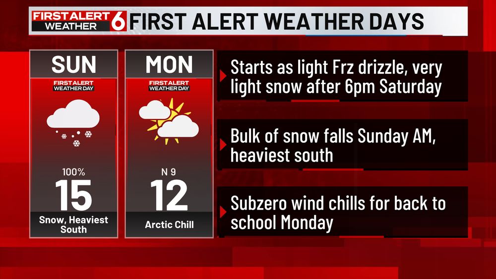
Image 3
FIRST ALERT to a little light icing potential Sat night between 6pm & midnight before changing to light snow for the overnight. As you can see, not much in metro, perhaps a 0.10" down near KS border. THEN the snow will add up into Sun AM.
03.01.2025 14:28 — 👍 1 🔁 0 💬 0 📌 0

Image 1
Everything in the metro was less than 1" as expected. Quite a few 3" reports in Washington and Harrison county though.
02.01.2025 17:05 — 👍 2 🔁 0 💬 0 📌 0

Image 1
While there is a bit of randomness to where the isolated heavier amounts are possible tonight, some short range models hint at this yellow circled are being a place that could get up near 4" of snow. David City, Columbus, Wahoo, Schuyler and surround areas, heads up!
30.12.2024 16:01 — 👍 2 🔁 0 💬 0 📌 0

Image 1
FIRST ALERT to a whole bunch of winter heading our way. Another batch of snow possible Thursday morning. Saturday night into Sunday has great potential for widespread snow. Coldest air of the season behind all that too. Get ready for subzero temps and double digit below zero wind chills.
30.12.2024 12:42 — 👍 1 🔁 0 💬 1 📌 0

Image 1

Image 2
FIRST ALERT Weather Day is still on track for Monday. Chilly rain builds in and will change to rain after 6pm. Temperatures will be warm enough to lead to some melting at the start so therefore most of us should see less than 2" from this one by the time it ends no later than 3am
29.12.2024 14:03 — 👍 3 🔁 0 💬 1 📌 1

Image 1
Enjoy the weekend because it looks a lot colder to start off 2025!
27.12.2024 16:31 — 👍 2 🔁 0 💬 1 📌 0