The monsoon withdrawal remains stalled over #India but conditions are favorable for the monsoon to withdrawal from the rest of #Gujarat, more of #MadhyaPradesh & #UttarPradesh & some parts of #Maharashtra in the next day or so. Additional withdrawal is expected this weekend into next week.
09.10.2025 09:50 — 👍 0 🔁 0 💬 0 📌 0

A rex block is forming in W #Europe and likely transitions to an omega block early next week. As a result, dry and bright weather will continue across #Ireland, the #UK, #France & #Germany through next week, while spells of rain are likely in E #Spain & the Balearic Islands into early next week.
09.10.2025 08:11 — 👍 2 🔁 0 💬 0 📌 0

Typhoon #Halong is accelerating away from #Japan & the Izu Islands & will transition to an extra-tropical storm Friday night. The system will affect the Aleutian Islands & Bering Sea as a powerful extra-tropical storm this weekend.
09.10.2025 07:15 — 👍 0 🔁 0 💬 0 📌 0

Notable warm pool just below the surface, just off #Indonesia, in the eastern equatorial Indian Ocean (-IOD) & western equatorial #Pacific. Significant cool pool near & just below the surface in the eastern equatorial Pacific.
08.10.2025 14:05 — 👍 2 🔁 0 💬 1 📌 0

A developing rex block will result in dry & bright weather in the #UK & northwest #Europe well into next week, while spells of rain are expected in eastern #Spain & the Balearic Islands through Monday. The rex block can transition to an Omega block early next week.
08.10.2025 11:53 — 👍 4 🔁 0 💬 0 📌 0

Strong Typhoon #Halong has started it northeast turn & will pass near or over #Japan's southern Izu Islands Wednesday night/early Thursday. Halong will accelerate ENE Thursday & Friday then transitions to an extra-tropical storm well east of Japan by Sunday.
08.10.2025 08:59 — 👍 1 🔁 0 💬 0 📌 0

A new tropical depression has formed in the Philippine Sea & will track northwestward before turning northeast this weekend. This depression will likely become Tropical Storm #Nakri in the next day or two & can impact the #RyukyuIslands Friday night into Sunday, JST.
08.10.2025 07:14 — 👍 1 🔁 0 💬 0 📌 0

Powerful Typhoon #Halong has started its N turn & will hook NE later Wednesday, then accelerate ENE Thurs & Fri, then will transition to an extratropical storm late Fri or Sat. The storm will batter #Japan's Izu Islands later Wed into Thurs, while brushing far SE Honshu.
07.10.2025 19:21 — 👍 1 🔁 0 💬 0 📌 0

Latest weekly IOD index for week ending 5 Oct was down to -1.49°C. The -IOD will hold through boreal autumn/austral spring then a neutral IOD returns in early boreal winter/austral summer.
07.10.2025 14:28 — 👍 1 🔁 0 💬 0 📌 0

A rex block will set up over W #Europe late this week & weekend, then may transition to an omega block next week. This will result in a stretch of quieter weather across NW Europe into next week, but another round of heavy rain is possible in E #Spain & the Balearic Islands this weekend.
07.10.2025 12:57 — 👍 2 🔁 0 💬 0 📌 0

A shortwave can bring a bit of rain & snow to the central #Andes Saturday, then can result in areas of heavy rain & thunderstorms in the Pampas of #Argentina, #Uruguay & southeast #Brazil later Saturday and Sunday.
07.10.2025 12:04 — 👍 1 🔁 1 💬 0 📌 0

A developing tropical low west of the Northern Mariana Islands is expected to strengthen as it drifts northwest over the next few days. The low can become Tropical Storm #Nakri by Friday then can impact #Japan's Izu Islands early next week.
07.10.2025 10:56 — 👍 1 🔁 0 💬 0 📌 0

#Shakhti is now a deep depression off #Oman & will rapidly dissipate over the open Arabian Sea during the next couple of days. Monsoon withdrawal will resume later this week after being stalled for nearly two weeks. #India
07.10.2025 08:31 — 👍 2 🔁 0 💬 0 📌 0

Typhoon #Halong will make a hard turn to the east over the next day or so, but can brush southeast #Japan with some wind & rain late Wednesday night into Thursday, local time.
07.10.2025 07:32 — 👍 2 🔁 0 💬 0 📌 0

Former #Matmo is over far western #Guangxi province & will continue to weaken, but areas of heavy rain will continue in northern #Vietnam, western Guangxi and southern #Yunnan provinces in #China into Tuesday, local time.
06.10.2025 20:36 — 👍 1 🔁 0 💬 0 📌 0

After being stalled for nearly two weeks, the southwest monsoon will resume its withdrawal from #India over the next few days.
06.10.2025 10:41 — 👍 1 🔁 0 💬 0 📌 0

Tropical Storm #Halong has formed S of #Japan & is expected to make a sharp hook eastward around midweek as the storm rides the gap between a pair of ridges in the NW #Pacific. The storm could make a close enough pass to bring some rain & wind to SE Japan Wednesday night & Thursday, local time.
05.10.2025 22:39 — 👍 2 🔁 0 💬 0 📌 0

Severe Tropical Storm #Matmo is over southwest #Guangxi province, #China, near the #Vietnam border. Matmo will rapidly weaken overland Monday, but heavy rain will remain a problem over the region through Monday.
05.10.2025 21:15 — 👍 2 🔁 0 💬 0 📌 0

A building ridge will lead to a quieter and drier pattern across #Ireland, the #UK, and western #Europe this week.
05.10.2025 19:02 — 👍 2 🔁 0 💬 0 📌 0
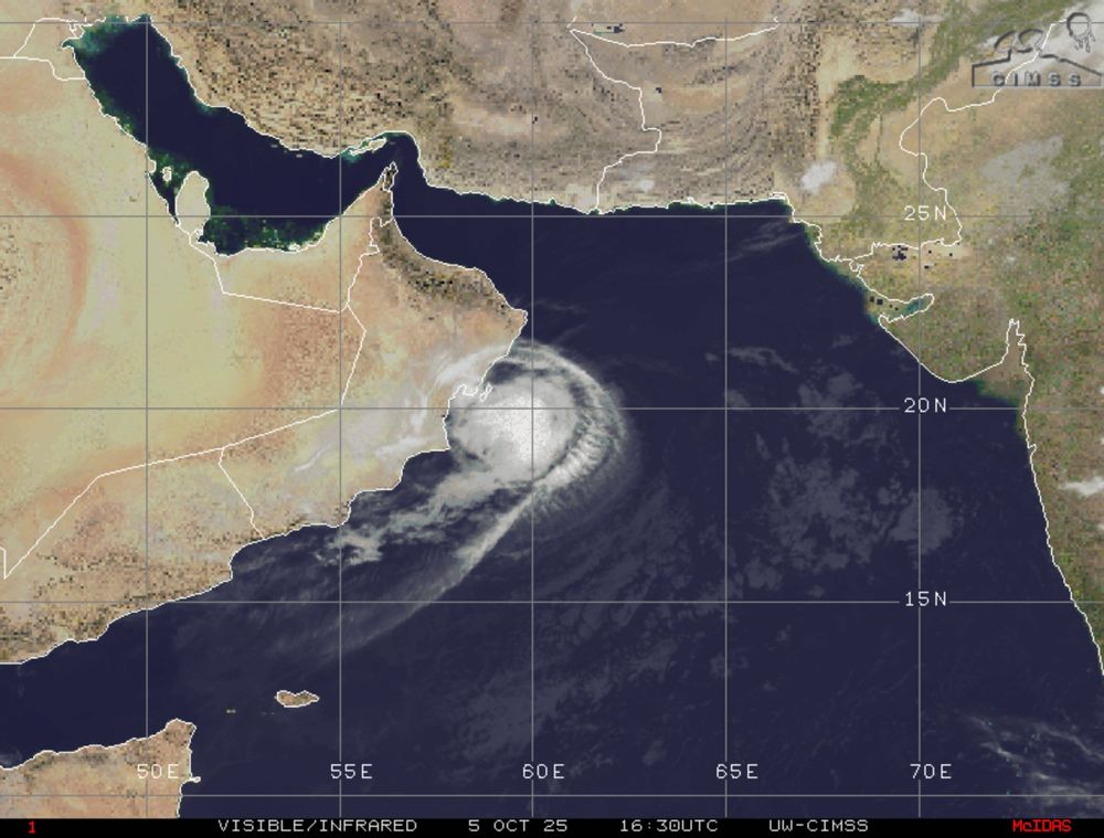
Severe Cyclonic Storm #Shakhti will weaken as it drifts SSW over the next 24-hours, then turns eastward & weakens to a depression by Tuesday afternoon. Shakhti will dissipate over the Arabian Sea by the weekend.
05.10.2025 18:25 — 👍 1 🔁 0 💬 0 📌 0

They died fighting Hitler and Mussolini for those not history savvy, including the current administration.
05.10.2025 18:12 — 👍 1 🔁 0 💬 0 📌 0

Cyclonic Storm #Shakhti has formed in the AS & will remain slow-moving until a western disturbance pulls it back E toward #Gujarat early next week. Shakhti will weaken before reaching W #India but will produce some rain. The WD will bring some rain to N #Pakistan & NW India early next week.
03.10.2025 13:25 — 👍 1 🔁 0 💬 0 📌 0

Severe Tropical Storm #Matmo/#Paolo is pushing into the South China Sea after crossing #Luzon & will strengthen to a typhoon before impacting #HainanIsland & the #Leizhou Peninsula on Sunday, local time.
03.10.2025 12:01 — 👍 1 🔁 0 💬 0 📌 0


The low that will become #StormAmy is under the right rear entrance region of a vigorous jet streak, then moves to the left front exit region of the jet streak as it nears #Ireland & #UK on Friday. This will result in rapid intensification over the next 24 hours.
02.10.2025 19:26 — 👍 1 🔁 0 💬 0 📌 0

The marine heatwave in the NW Pacific will help maintain a ridge near #Japan through at least mid-October which should continue to favor WNW tracks for any TCs during the next couple of weeks. The -IOD will also help keep the main development area in the W Pacific shifted west of 150°E.
02.10.2025 14:45 — 👍 1 🔁 0 💬 0 📌 0

#StormAmy will bring damaging wind gusts and areas of heavy rain to the #UK & #Ireland Friday into the weekend. The strongest winds will be in northern Ireland & #Scotland where wind gusts in excess of hurricane force (74 mph/119 km/h) are likely.
02.10.2025 13:14 — 👍 1 🔁 0 💬 0 📌 0

Deep depression in the NW BOB will make landfall between #Gopalpur & #Paradip Thursday night into move toward E #UttarPradesh & #Nepal Friday & this weekend. Depression in the AS may eventually turn back E into #Gujarat around Tuesday. Risk of isolated showers in S #Pakistan into Friday.
02.10.2025 09:27 — 👍 1 🔁 0 💬 0 📌 0

Tropical Storm #Matmo/#PaoloPH can become a severe tropical storm before crossing northern #Luzon Friday & Friday night, local time. Matmo can impact Hainan Island, southern #China & northern #Vietnam as a typhoon on Sunday & Monday, local time.
02.10.2025 07:56 — 👍 1 🔁 1 💬 0 📌 0

Models showing #StormAmy as a Shapiro-Keyser Cyclone with a developing warm seclusion so need to watch for a sting jet. The location is hard to pin down due to it being a short-lived mesoscale phenomena.
01.10.2025 14:48 — 👍 1 🔁 0 💬 0 📌 0

Conditions will remain conducive for additional tropical development in the Philippine Sea next week. Steering flow should favor another west-northwest track which can result in impacts on #Taiwan & eastern #China heading into the week of 13 Oct.
01.10.2025 13:59 — 👍 1 🔁 0 💬 0 📌 0
Connect with others who share the same fetish.
Follow and get followed back.
All fetishes: go.bsky.app/E3VGKMv
Website coming soon: nylonfeet.vestiphilia.com
Contact: @vestiphilia.com
A photo viewing client for u from the creator of @skeetsapp.com & @bluescreen.blue
iOS: https://t1p.de/b3o4x
Android: Not available yet
❓ FAQS: https://t1p.de/24kj0
🐞 Bug Reports: https://t1p.de/phwii
💡 Feature Requests: https://t1p.de/8tmnc
パンストフェチ集まれ!パートナーのパンスト晒します
Recommended for pantyhose fetish♡
Look at my partner's pantyhose♡
18+ Pantyhose are my passion, they are what I desire. Sharing my love of all things nylon & showing you pieces of my pantyhose life.
https://dawndesireph.com for my links.
UKRI Future Leaders Fellow & Essex Uni Assoc Prof. Marine biologist obsessed with 🐟 movement. FSBI Council, Fish & Fisheries Editor. Otolith starter pack: https://go.bsky.app/2TPiypt. Video game/ animation about connectivity: www.tinyurl.com/MFCTeacherPack
Greek Cypriot. Sheffield, UCL & SGUL Graduate. NHS. MBBS MSc BSc. Adrenaline Junkie. Travel. Food. Football THFC #MedSky #Travel #COYS
🍁 #Canada 🇨🇦 Visual storyteller, wife, mom, nana! Visit my website: https://karencook.pixels.com/ Nature photography Photos are copyrighted. Proceeds from sales go to #charity #KindnessMatters Proud to live in Canada ♥️🇨🇦
Linux Australia is the peak body for Linux User Groups (LUGs) around Australia, representing #linux & #OpenSource users | https://fosstodon.org/@LinuxAustralia
https://linux.org.au
News Junkie , Twitter refugee
Weather-Climate professor and scientist, Host of Weather Geeks, Forbes Senior Contributor, Alpha, 3xFSU Alum...Tweets and RTs are mine but not endorsements
Energy Trading + weather watching
Fan of North Melbourne F.C , Horse Racing, weather & cold beers in the sun!!!
Rocket Scientist 🚀 turned Tech CEO; Senior Fellow Lockheed Martin; Notre Dame PhD☘️; Wrote cool stuff for Forbes, & Proud Autism Dad! ♥️