11.10.2025 16:02 — 👍 0 🔁 0 💬 0 📌 0
YouTube video by ARRLHQ
Help Us Pass the Amateur Radio Emergency Preparedness Act
Let's get the #HouseGOP, #HouseDemocrats, #SenateGOP and #SenateDems to pass the Amateur Radio Emergency Preparedness Act (It's H.R.1094 in the House and S.459 in the Senate). See 👇 on how #hamradio operators nationwide can help pass this bipartisan bill.
youtu.be/CxXh6Dh1-5o?...
29.09.2025 14:15 — 👍 10 🔁 3 💬 0 📌 0

@jkl.nws-bot.us #JKL issued a Hazardous Weather Outlook (HWO) at 3:22 AM EDT on 24 Sep for Eastern Kentucky. Details 👉 at mesonet.agron.iastate.edu/wx/afos/p.ph... #ekywx #kywx #StormSpotters #StayWeatherAware
24.09.2025 11:41 — 👍 0 🔁 1 💬 0 📌 0

@sdf.nws-bot.us #LMK issued a Hazardous Weather Outlook (HWO) at 3:09 AM EDT on 24 Sep for Central Kentucky and Southern Indiana. Details 👉 at mesonet.agron.iastate.edu/wx/afos/p.ph... #kywx #inwx #StormSpotters #StayWeatherAware
24.09.2025 11:39 — 👍 0 🔁 1 💬 0 📌 0


Daily @cocorahskyjc6.bsky.social report for 24 Sep 2025 to #nwsjacksonky & #CoCoRaHS for #ekywx #DanielBooneNF & #kymesonet using #Logia7in1WiFi #PWS w/ a #CoCoRaHS-approved Rain gauge. This station's #wxdata can be found 24/7/365 at wunderground.com/pws/dashboar... #ShareYourWeather #BeWeatherAware
24.09.2025 11:43 — 👍 0 🔁 1 💬 0 📌 0

REMINDER*
WHAT: #APRSTHURSDAY net
WHEN: 25-SEP-2025 00:00 - 23:59 UTC
HOW: Destination Station = ANSRVR
HOW: Message body = CQ [space] HOTG [space] your message text.
#APRSTHURSDAY: The weekly net that fits everyone’s schedule.
24.09.2025 12:31 — 👍 1 🔁 1 💬 0 📌 0

The forecast across Central Kentucky and Southern Indiana calls for mostly dry conditions and warming temps through the end of the week and into the weekend. High will be 90 by Sat and Sun. There's a very small chc. of a sprinkle tonight into tomorrow but those chc. are low. Forecast weather.gov/lmk
10.09.2025 12:38 — 👍 1 🔁 1 💬 0 📌 0
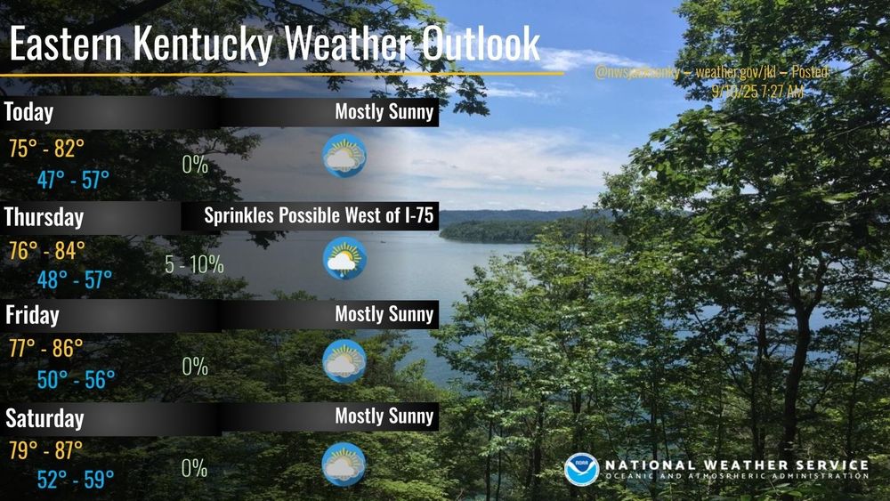
High pressure will remain the dominant weather feature across Eastern Kentucky through early next week. Temperatures will gradually warm, reaching near to slightly above normal levels by Friday. No measurable rainfall is expected through early next week. #kywx #ekywx
10.09.2025 12:25 — 👍 1 🔁 1 💬 0 📌 0

Daily @cocorahskyjc6.bsky.social report for 10 Sep 2025 to #nwsjacksonky & #CoCoRaHS for #ekywx #DanielBooneNF & #kymesonet using #Logia7in1WiFi #PWS w/ a #CoCoRaHS-approved Rain gauge. This station's #wxdata can be found 24/7/365 at wunderground.com/pws/dashboar... #ShareYourWeather #BeWeatherAware
10.09.2025 12:10 — 👍 1 🔁 1 💬 0 📌 0

*REMINDER*
WHAT: #APRSTHURSDAY net
WHEN: 11-SEP-2025 00:00 - 23:59 UTC (or from 10-SEP 1900 to 11-SEP 1859 EDT)
HOW: Destination Station = ANSRVR
HOW: Message body = CQ [space] HOTG [space] your message text.
#APRSTHURSDAY: The weekly net that fits everyone’s schedule.
10.09.2025 12:31 — 👍 1 🔁 0 💬 0 📌 0
September is National Preparedness Month. Are you ready in case of an emergency? x.com/KB9LXH/statu...
09.09.2025 22:59 — 👍 4 🔁 2 💬 1 📌 0
Atlanta based #HamRadio Usable HF Frequencies via hfpropagation.com
08.09.2025 18:31 — 👍 2 🔁 0 💬 0 📌 0

Global Optimum NVIS Frequency Map Based Upon Hourly Ionosphere Soundings via sws.bom.gov.au/HF_Systems/6/5 #hamradio
08.09.2025 18:31 — 👍 2 🔁 0 💬 0 📌 0

#HamRadio #APRS MSG from #KB9LXH-5 to #WA1GOV-10 #WXBOTCUR 5 mi. SSW Sandgap KY P. Cldy T 66.7F H 69% B 29.89inHg
07.09.2025 20:12 — 👍 2 🔁 1 💬 0 📌 0

The peak of hurricane season is September 10th. We're not tracking ANYTHING in the Atlantic right now! A rare treat for this time of year. Enjoy it!
07.09.2025 12:08 — 👍 4 🔁 1 💬 0 📌 0


Daily @cocorahskyjc6.bsky.social report for 7 Sep 2025 to #nwsjacksonky & #CoCoRaHS for #ekywx #DanielBooneNF & #kymesonet using #Logia7in1WiFi #PWS w/ a #CoCoRaHS-approved Rain gauge. This station's #wxdata can be found 24/7/365 at wunderground.com/pws/dashboar... #ShareYourWeather #BeWeatherAware
07.09.2025 12:09 — 👍 0 🔁 1 💬 0 📌 0


@sdf.nws-bot.us #LMK issued a Hazardous Weather Outlook (HWO) at 6:32 AM EDT for Central Kentucky and Southern Indiana. Details 👉 at mesonet.agron.iastate.edu/wx/afos/p.ph... #kywx #inwx
07.09.2025 12:07 — 👍 0 🔁 1 💬 0 📌 0

@jkl.nws-bot.us #JKL issued a Hazardous Weather Outlook (HWO) at 3:18 AM EDT for Eastern Kentucky. Details 👉 at mesonet.agron.iastate.edu/wx/afos/p.ph... #ekywx #kywx
07.09.2025 12:05 — 👍 1 🔁 1 💬 0 📌 0

@jkl.nws-bot.us #JKL issued a Dense Fog Advisory till Sep 7, 10:00 AM EDT for Eastern Kentucky. Details 👉 at mesonet.agron.iastate.edu/vtec/?year=2... #ekywx #kywx
07.09.2025 11:53 — 👍 0 🔁 1 💬 0 📌 0

Due to widespread dense fog causing visibility to fall to 1/4 mile; a Dense Fog Advisory was issued for Eastern Kentucky by #JKL and is in effect until 10 AM this morning. #kywx #ekywx #BePrepared #StayWeatherAware
07.09.2025 11:49 — 👍 1 🔁 1 💬 0 📌 0

WHAT: #APRSTHURSDAY net
WHEN: 04-SEP-2025 00:00 - 23:59 UTC
HOW: Set Destination Station = ANSRVR
HOW: Enter Message body = CQ [space] HOTG [space] your message text.
NOTE: APRSPH is undergoing some changes and may not be available for use this week.
04.09.2025 03:24 — 👍 2 🔁 0 💬 0 📌 0

This is what true Christianity is supposed to look like!
02.09.2025 04:59 — 👍 2 🔁 2 💬 0 📌 0

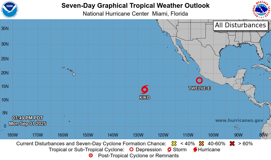
ZCZC MIATWOEP ALL<br>TTAA00 KNHC DDHHMM<br><br>Tropical Weather Outlook<br>NWS National Hurricane Center Miami FL<br>500 PM PDT Mon Sep 1 2025<br><br>For the eastern and central North Pacific east of 180 longitude:<br><br>Active Systems: <br>The National Hurricane Center is issuing advisories on Tropical <br>Storm Kiko, located in the east Pacific basin well west-southwest <br>of the southern tip of the Baja California peninsula. Kiko is <br>expected to cross into the central Pacific basin by the weekend.<br><br>1. South of Southwestern Mexico (EP94):<br>Showers and thunderstorms are becoming better organized in <br>association with a broad area of low pressure located a little more <br>than 100 miles off the coast of southwestern Mexico. In addition, <br>earlier satellite-derived wind data indicate that winds to 35 mph <br>are occurring on its north side, close to the coast of Mexico. This <br>system is expected to become a tropical depression or tropical storm <br>in the next day or so while it moves west-northwestward at 10 to 15 <br>mph off the coast of southwestern Mexico. The disturbance is <br>expected to turn northwestward toward the Baja California peninsula <br>later in the week, and watches or warnings could be required for <br>portions of that area on Tuesday. Regardless of development, heavy <br>rainfall is possible across coastal portions of southwestern and <br>west-central Mexico during the next few days, and these rains will <br>likely spread to Baja California Sur later in the week. The heavy <br>rains could lead to flash flooding, especially in mountainous areas.<br>* Formation chance through 48 hours...high...90 percent.<br>* Formation chance through 7 days...high...90 percent.<br><br><br><br>Forecaster Cangialosi<br><br><br>

Eastern North Pacific 2-Day Graphical Outlook Image
Eastern North Pacific 7-Day Graphical Outlook Image
NHC Eastern North Pacific Outlook update for Tue, 02 Sep 2025 02:49:17 UTC
Additional Details Here.
02.09.2025 02:50 — 👍 1 🔁 2 💬 0 📌 0

000WTPZ32 KNHC 020242TCPEP2 BULLETINTropical Depression Twelve-E Advisory Number 1NWS National Hurricane Center Miami FL EP122025900 PM CST Mon Sep 01 2025 ...TROPICAL DEPRESSION FORMS TO THE SOUTH OF SOUTHWESTERN MEXICO... SUMMARY OF 900 PM CST...0300 UTC...INFORMATION----------------------------------------------LOCATION...17.2N 105.4WABOUT 145 MI...230 KM SSW OF MANZANILLO MEXICOMAXIMUM SUSTAINED WINDS...35 MPH...55 KM/HPRESENT MOVEMENT...WNW OR 295 DEGREES AT 14 MPH...22 KM/HMINIMUM CENTRAL PRESSURE...1007 MB...29.74 INCHES WATCHES AND WARNINGS--------------------There are no coastal watches or warnings in effect.Interests in southwestern Mexico and Baja California Sur shouldmonitor the progress of this system. A Tropical Storm Watch could be required for portions of Baja California Sur on Tuesday. DISCUSSION AND OUTLOOK----------------------At 900 PM CST (0300 UTC), the center of Tropical Depression Twelve-Ewas located near latitude 17.2 North, longitude 105.4 West. Thedepression is moving toward the west-northwest near 14 mph (22 km/h), and a gradual turn toward the northwest and north-northwest with a decrease in forward speed is expected over the next couple of days. Maximum sustained winds are near 35 mph (55 km/h) with higher gusts.Strengthening is forecast, and the system will likely become atropical storm on Tuesday.The estimated minimum central pressure is 1007 mb (29.74 inches). HAZARDS AFFECTING LAND----------------------RAINFALL: Areas of heavy rainfall well east and northeast of the depression will continue to impact portions of northwestern Mexico from the states of Colima to Sinaloa tonight into Tuesday, with isolated flash flooding possible in areas of mountainous terrain.Bands of heavy rainfall are expected to begin impacting portions of Baja California Sur by Wednesday and persist through Friday. Rainfall totals of 4 to 8 inches are possible here, although there is uncertainty with these totals, and higher amounts are possible. Potentially significant flash flooding is a possibility depending on the track and strength of the system. NEXT ADVISORY-------------Next complete advisory at 300 AM CST. $$Forecaster Pasch

Tropical Depression Twelve-E 5-Day Uncertainty Track Image

Tropical Depression Twelve-E 34-Knot Wind Speed Probabilities
Eastern North Pacific Tropical Depression Twelve-E Advisory Number 1 issued at Tue, 02 Sep 2025 02:42:42 +0000
...TROPICAL DEPRESSION FORMS TO THE SOUTH OF SOUTHWESTERN MEXICO...
Additional Details Here.
02.09.2025 02:50 — 👍 0 🔁 2 💬 0 📌 0

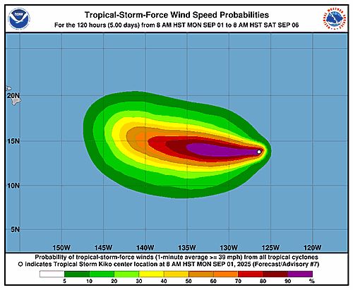
147 WTPZ31 KNHC 020248TCPEP1 BULLETINTropical Storm Kiko Advisory Number 8NWS National Hurricane Center Miami FL EP112025500 PM HST Mon Sep 01 2025 ...KIKO MAINTAINS STRENGTH AND CONTINUES WESTWARD... SUMMARY OF 500 PM HST...0300 UTC...INFORMATION----------------------------------------------LOCATION...13.8N 127.3WABOUT 1880 MI...3025 KM E OF HILO HAWAIIMAXIMUM SUSTAINED WINDS...65 MPH...100 KM/HPRESENT MOVEMENT...W OR 265 DEGREES AT 7 MPH...11 KM/HMINIMUM CENTRAL PRESSURE...993 MB...29.33 INCHES WATCHES AND WARNINGS--------------------There are no coastal watches or warnings in effect. DISCUSSION AND OUTLOOK----------------------At 500 PM HST (0300 UTC), the center of Tropical Storm Kiko waslocated near latitude 13.8 North, longitude 127.3 West. Kiko ismoving toward the west near 7 mph (11 km/h). This general motion is expected to continue during the next couple of days. Maximum sustained winds are near 65 mph (100 km/h) with higher gusts. Steady strengthening is forecast during the next couple of days, and Kiko is expected to become a hurricane tonight. Tropical-storm-force winds extend outward up to 45 miles (75 km)from the center. The estimated minimum central pressure is 993 mb (29.33 inches). HAZARDS AFFECTING LAND----------------------None. NEXT ADVISORY-------------Next complete advisory at 1100 PM HST. $$Forecaster Jelsema (CPHC)

Tropical Storm Kiko 5-Day Uncertainty Track Image
Tropical Storm Kiko 34-Knot Wind Speed Probabilities
Eastern North Pacific Tropical Storm Kiko Advisory Number 8 issued at Tue, 02 Sep 2025 02:48:59 +0000
...KIKO MAINTAINS STRENGTH AND CONTINUES WESTWARD...
Additional Details Here.
02.09.2025 02:50 — 👍 0 🔁 2 💬 0 📌 0

ZCZC MIATWOAT ALL<br>TTAA00 KNHC DDHHMM<br><br>Tropical Weather Outlook<br>NWS National Hurricane Center Miami FL<br>800 PM EDT Mon Sep 1 2025<br><br>For the North Atlantic...Caribbean Sea and the Gulf of America:<br><br>1. Eastern Tropical Atlantic:<br>A tropical wave located over the far eastern tropical Atlantic <br>south of the Cabo Verde islands is producing disorganized showers <br>and thunderstorms. Environmental conditions appear conducive for <br>gradual development of this system, and a tropical depression could <br>form by the middle or latter part of this week. This system is <br>expected to move westward to west-northwestward at around 15 mph <br>across the eastern and central tropical Atlantic throughout the <br>week.<br>* Formation chance through 48 hours...low...10 percent.<br>* Formation chance through 7 days...medium...60 percent.<br><br><br><br>Forecaster Pasch<br><br><br>

Atlantic 2-Day Graphical Outlook Image

Atlantic 7-Day Graphical Outlook Image
NHC Atlantic Outlook update for Mon, 01 Sep 2025 23:18:25 UTC
Additional Details Here.
01.09.2025 23:20 — 👍 13 🔁 6 💬 0 📌 0
1 Sep 2025 weather summary to #nwsjacksonky, #kymesonet, the #DanielBooneNF, and other parties.
High 83.3°F | Low 48.7°F | Pcpn. 0.00" | Snow: 0.0"
Note: #wxdata may be found 24/7/365 at wunderground.com/pws/dashboard/KKYMCKEE41 #ekywx #kywx #CWOP #ShareYourWeather
02.09.2025 03:24 — 👍 0 🔁 1 💬 0 📌 0

@sdf.nws-bot.us #LMK issued a Hazardous Weather Outlook (HWO) at 10:05 PM EDT on Sep 1 for Central Kentucky and Southern Indiana. Details 👉 at mesonet.agron.iastate.edu/wx/afos/p.ph... #StayWeatherAware #kywx #inwx
02.09.2025 03:23 — 👍 0 🔁 1 💬 0 📌 0
Rescues are my favorite breed. I let the dogs out. Seriously, someone had to do it...I work with words...sometimes. I'm an animal and music lover..nap taker...master whistler
#DogsofBluesky #CatsofBluesky #TGsLounge #TheOutpost #BlueResister #NeverTrumper
official Bluesky account (check username👆)
Bugs, feature requests, feedback: support@bsky.app
Here you will find a great selection of Ham Radio news, DXing, contest, pictures, videos & equipment in the wonderful world of this hobby.
Amateur Radio Extra Class Licensee, Short Wave Listening, Utility Monitoring, Scanning. Technical Writer. Nerdy Old Man.
Extra Class Amateur radio operator - EN53cb
Ham radio stuff and other good things.
Radio ham since 1993 , Got back into the Hobby during covid and a broken shoulder in 2022.
Main operation is Allstar & YSF + VoIP With Hams Over IP Support Team Member 👏 Amateur Radio On A SIP Enabled Internet Phone
Retired living in Hawaiian rain forest. Tall trees for antenna support. International shortwave point to point communications for fun and during emergencies. Practicing high speed radiotelegraphy. Vietnam vet.
Quality products and US based support for Amateur Radio and GMRS operators.
Fitness freak, Pilates instructor, indie music photographer, cats, tea n biscuits and southern comfort after dark!
Practically perfect 😉
Humanitarian. World traveler. Ham radio enthusiast aka KL2R. Alaskan. Former Cold Warrior, RF systems engineer, UNHCR. Proud to serve as a NOAA leader for two decades. Secular humanist. Committed to making the world around me a better place.
26 | uOttawa alumni | Cozy Fantasy Author | she/her 🌈 write words, I do. (not always Yoda-approved) #amwriting #amquerying
Tampa Bay 28 Meteorologist/Traffic Anchor| a girl with her head in the clouds ☁️ | RDU➡️LEX➡️BAL➡️TPA| NC State ❤️🐺 | AMS Certified (#988)
I’m a Jersey girl how you doing? I love sports and animals. I have a heart of gold. I have a crazy sense of humor. Let’s be friends.
Poet & essayist. Narratives driven by lived experience. Dystopian novels. Screenplays. The🦮always lives #FinalGirl #DarknTwisty #SlightlyFeral
Life long Democrat. Despise Trump. Blue dot in a very red state, planning a move to Chicago within months!💙🩵💙
Professional Life Researcher 🧐
Lover of life, animals (vegan 🌱), the skies, the moon, nature, photography, the beach, the mysteries of the Universe.
I am grateful ♥️
Canada 🇨🇦
Wife, Mother, Attorney (Ret.), Double ‘Hoo (UVa BA ‘87; UVa JD ‘90) 💙