What's New in #ArcGISPro 3.5 (May 2025) tinyurl.com/44fyvswc
#location #business #spatial #intelligence #spatialanalysis #GIS #esri #arcgis #mapping #GISchat #geospatial #TheScienceOfWhere #geosky

@dylanmolnar.bsky.social
Maps & Data. Product Marketer at Esri Previously: Maxar, National Geographic, University of Oregon, and City of San Francisco
What's New in #ArcGISPro 3.5 (May 2025) tinyurl.com/44fyvswc
#location #business #spatial #intelligence #spatialanalysis #GIS #esri #arcgis #mapping #GISchat #geospatial #TheScienceOfWhere #geosky

If you missed the live presentation yesterday at the Developer & Technology Summit, the Baron Weather team delivered an impressive keynote presentation. They showcased a demo using Velocity to connect to real-time wind gust data, filter high winds, and send alerts. Check it out:
14.03.2025 15:06 — 👍 0 🔁 0 💬 0 📌 0
The February 2025 update of #ArcGISVelocity introduces new features and enhancements! Explore new real-time flight tracking with @FlightAware, hyperlocal weather data from @BaronWeather, and Microsoft Teams & Slack outputs for alerts.
Learn more: www.esri.com/arcgis-blog/...

Don't miss out! FedGIS is happening next week. Dive into the world of real-time GIS with our blog and get ready with a comprehensive overview of all the relevant sessions. Check it out: https://buff.ly/3Q0KPWC #FedGIS #GIS
20.02.2025 16:43 — 👍 0 🔁 0 💬 0 📌 0
Discover how GIS technology is transforming airport safety and security. From enhancing operational efficiency to ensuring passenger safety, GIS is elevating airport management to new heights. Learn more about this innovative approach! #SmartAirports #GIS
19.02.2025 16:43 — 👍 0 🔁 0 💬 0 📌 0Also, I wanted to let you know that we are working on bringing Velocity to Enterprise! We'd like to hear what you would like to see in the product.
18.02.2025 13:28 — 👍 0 🔁 0 💬 0 📌 0Hi Andy! I am the product marketer for GeoEvent. I totally understand your frustration with GeoEvent. It can be a powerful tool, but it can be challenging to work with. I'd love to connect with you and see if I can point you in the right direction.
18.02.2025 13:28 — 👍 0 🔁 0 💬 1 📌 0San Francisco International Airport (SFO) maintains close to 11,000 lights on the airfield that are critical to the safe operations of aircraft both airborne and on the ground. VIew this award winning map from the Esri User Conference Map Gallery: https://buff.ly/40OsYYh
14.02.2025 21:59 — 👍 0 🔁 0 💬 0 📌 0Discover how Arizona Department of Environmental Quality boosted efficiency and reliability with #ArcGISMonitor! By optimizing resources and reducing downtime, ADEQ ensures their robust enterprise GIS supports vital environmental protection efforts: https://buff.ly/413zJqv
13.02.2025 16:43 — 👍 1 🔁 0 💬 0 📌 0More fire departments are embracing GIS and geospatial analysis, to great results. Read now in Geo Week News: https://buff.ly/4jOqD8q
12.02.2025 16:43 — 👍 1 🔁 0 💬 0 📌 0Optimize and manage #WinterWeatherOperations in real-time with #ArcGISVelocity based #ArcGIS Solutions. Develop response plans, monitor operations in real-time, share status updates, and track vehicle locations/materials. Learn more: https://buff.ly/42ICIpw
11.02.2025 21:59 — 👍 0 🔁 1 💬 0 📌 0Join us at #FedGIS2025 to learn how #ArcGIS Data Reviewer enhances data quality and cuts down on management costs. Discover how to define quality requirements and integrate Data Reviewer with your geodatabase: buff.ly/4i3ew5J #DataQuality
10.02.2025 21:59 — 👍 0 🔁 0 💬 0 📌 0The latest #ArcGISVelocity based Mowing Operations solution helps governments efficiently manage seasonal mowing. It enables precise planning, centralizes data, and monitors real-time performance, ensuring compliance and enhancing community safety. https://buff.ly/4hH6AXx
10.02.2025 16:43 — 👍 0 🔁 0 💬 0 📌 0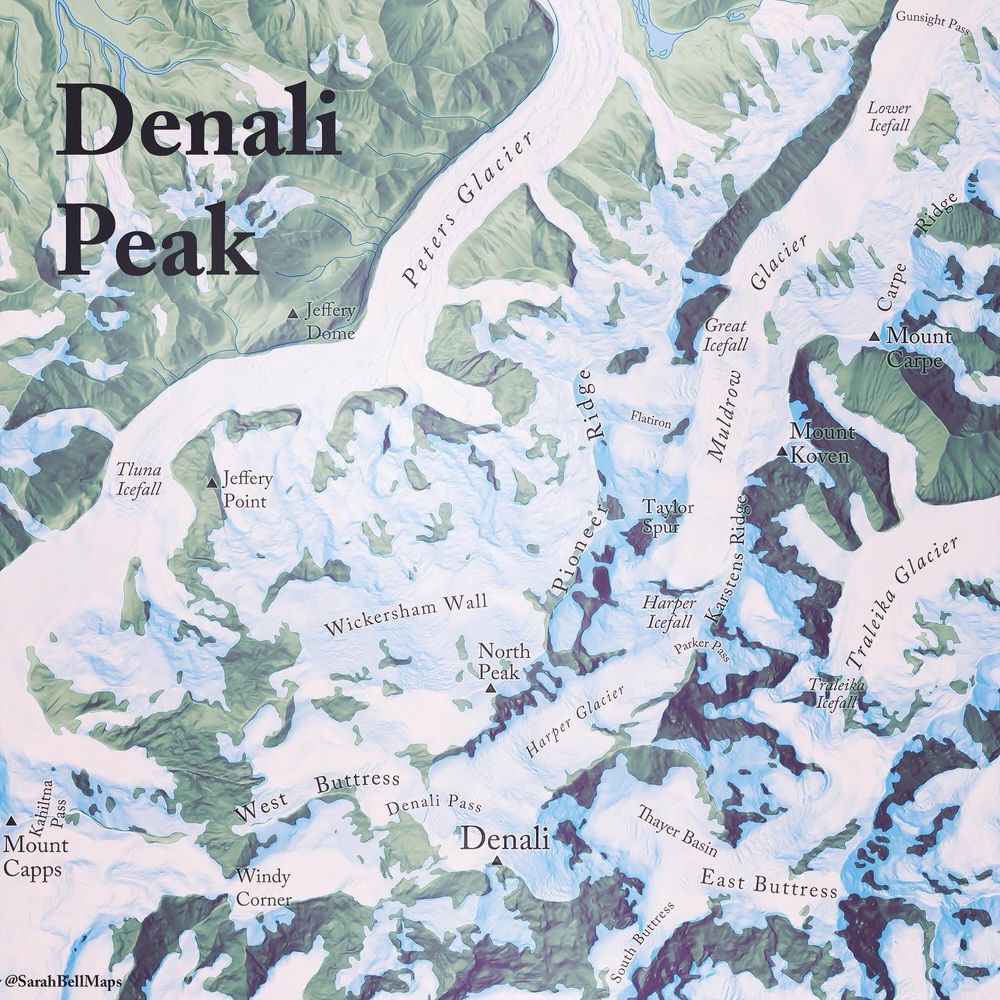
Map of the area around Denali
Map of the Day: Denali, the highest peak North America at 20,310 feet (6,190 m). Centuries ago, the Koyukon people gave it the name which means ‘Great One.’ Popular among climbers, the mountain is within Denali National Park.
05.02.2025 16:15 — 👍 67 🔁 14 💬 5 📌 0This is such a useful Storymap, thanks for sharing!
07.02.2025 21:27 — 👍 0 🔁 0 💬 0 📌 0Check out the demo to see how #MapsforAdobe simplifies the process of taking maps from #GIS to design. See how we created the Pacific Northwest map poster using Pro-to-Illustrator workflows, automated symbol replacement & more! #GIS #Design https://buff.ly/3Q2pImO
07.02.2025 16:43 — 👍 0 🔁 0 💬 0 📌 0
Ensuring high-quality data for efficient operations, compliance, and customer satisfaction is essential for water utilities. Watch our recent webinar recording to explore best practices when migrating to the Utility Network:
06.02.2025 21:59 — 👍 0 🔁 0 💬 0 📌 0Safety and security are top priorities for every airport. Discover how smart airports are using cutting-edge #GIS to boost efficiency, enhance situational awareness, and improve decision-making in operations, emergency response, and more. Learn more: https://buff.ly/4jZUQl1
06.02.2025 16:43 — 👍 0 🔁 0 💬 0 📌 0
Join us at #FedGIS to learn about #ArcGISGeoEventServer, an extension for #ArcGISEnterprise, bringing powerful real-time capabilities for ingesting, analyzing, and disseminating critical information. Check out the helpful information on all real-time #GIS sessions!
05.02.2025 16:43 — 👍 0 🔁 0 💬 0 📌 0Great resource to find the latest on Indoor GIS at #FedGIS2025! Check out the indoor map of the event.
04.02.2025 21:19 — 👍 1 🔁 0 💬 0 📌 0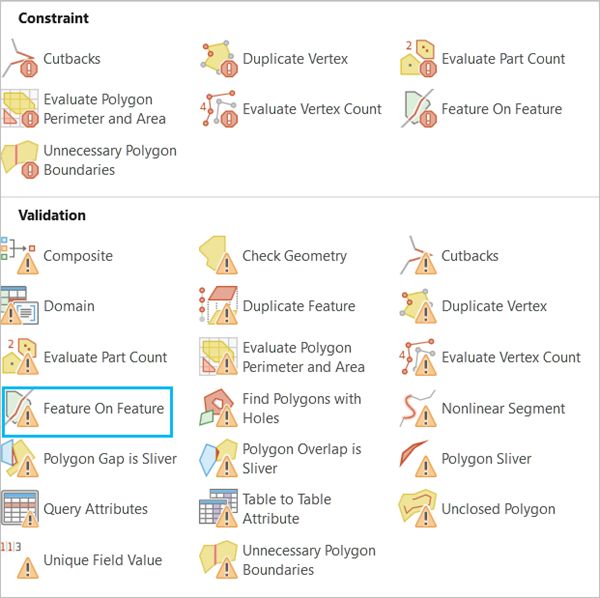
High-quality data helps save resources and reduce costs. Check out our new tutorial on creating validation rules in #ArcGIS Enterprise using ArcGIS Data Reviewer. See the benefits of ensuring your #GIS data meets quality standards and contains fewer errors. https://buff.ly/4jI7lRS
04.02.2025 16:43 — 👍 1 🔁 0 💬 0 📌 0
Heading to #FedGIS? Learn about advancements in #ArcGISVelocity, an extension for #ArcGISOnline, that brings powerful real-time capabilities for ingesting, analyzing, and disseminating critical information. Check out the helpful information on all real-time GIS sessions! https://buff.ly/3Q0KPWC
03.02.2025 21:59 — 👍 0 🔁 0 💬 0 📌 0
The City of Syracuse is tracking and mapping snowplows during winter events. See how this system is helping improve road safety, reduce costs, and provide residents with up-to-date information on snow removal progress. Check out the story: www.esri.com/about/newsro...
03.02.2025 17:30 — 👍 0 🔁 0 💬 1 📌 0