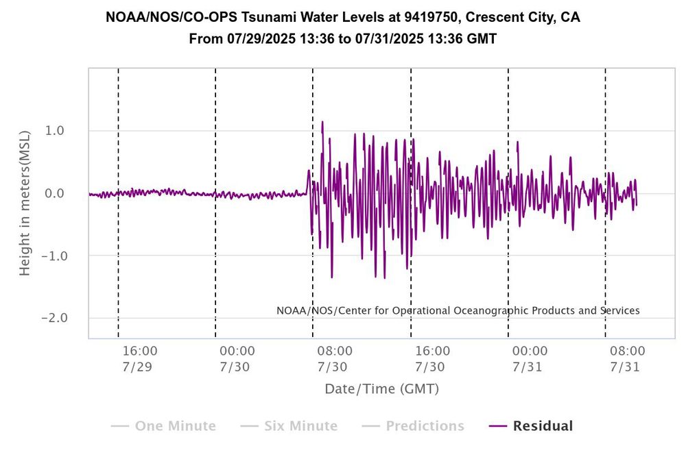
Crescent city river gauge record
Just to illustrate how long waves from a #tsunami can keep going, this is a tide gauge record from Crescent City CA (known for its sensitivity to tsunami waves due to bathymetric and resonance effects) showing significant wave activity still continues 24+ hours after their first arrival. 🧪⚒️
31.07.2025 10:41 — 👍 75 🔁 29 💬 3 📌 4
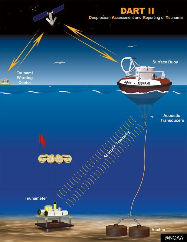
A National Oceanic & Atmospheric Administration (NOAA) diagram illustrating how tsunami wave information in the deep ocean is transmitted to tsunami warning centers (right)
Kamchatka earthquake highlights the advances in tsunami early warning systems 🌊 🛰️
BGS Prof David Tappin, Marine Geologist & tsunami expert explains how the Kamchatka event highlighted the improved mitigation measures now in place.
www.bgs.ac.uk/news/kamchat...
31.07.2025 15:55 — 👍 20 🔁 10 💬 0 📌 1
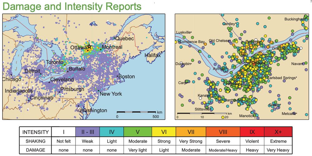
Maps showing how the June 23, 2010 M5 earthquake near Val des Bois, Quebec, was felt across eastern North America (to a distance of nearly 1000 km). Map on the right is a closeup of felt shaking reports from the epicentral region where some damage occurred and landslides were triggered.
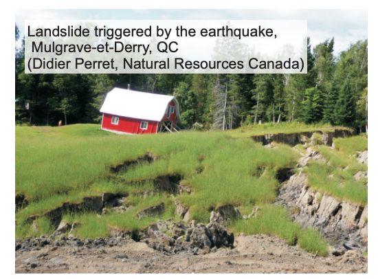
Photo of a red barn that was impacted by a landslide following a M5 earthquake in Quebec. Brown soils outline the landslide, with green grassy fields and trees in the background.
Earthquakes in eastern #Canada? June 23, 2010 - a damaging M5 #earthquake in western Québec was felt in Ontario, #Québec and as far away as Washington DC. It triggered landslides and produced the strongest shaking ever felt in #Ottawa (~60 km away): earthquakescanada.nrcan.gc.ca/pprs-pprp/pu...
⚒️🧪
22.06.2025 15:23 — 👍 27 🔁 8 💬 1 📌 1
With an eruption at Mt. Etna earlier this month also sending ash 6.4km high, leading to warnings for aviation, volcanoes remain a constant but often overlooked risk for tourism, supply chains & the maritime sector, as well as local infrastructure.
19.06.2025 10:20 — 👍 3 🔁 0 💬 0 📌 0
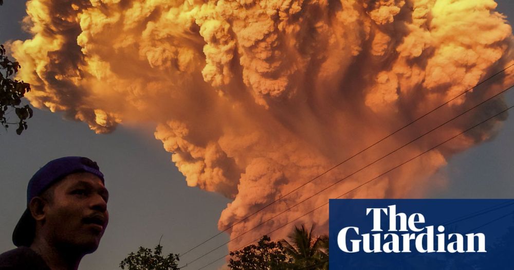
Bali flights cancelled after Indonesian volcano spews 10km-high ash tower
Mount Lewotobi Laki-Laki on the island of Flores, east of Bali, erupted on Tuesday afternoon, leading to several airlines cancelling flights
On 17-18th June, explosive eruptions at Mt. Lewotobi Laki-Laki on the Indonesian island of Flores sent ash >11.5km above sea level. This highlights volcanic hazards on varying scales; pyroclastic flows & lahars threatening local communities, & ash leading to flight cancellations & delays.
19.06.2025 10:20 — 👍 6 🔁 2 💬 1 📌 0
The VAAC report for the Etna eruption today mentions a plume reaching 6,500 m / ~21,000 feet.
02.06.2025 10:56 — 👍 11 🔁 3 💬 0 📌 0
Pyroclastic flows at Etna have been confirmed by INGV ⚒️🌋
02.06.2025 09:56 — 👍 66 🔁 39 💬 2 📌 4
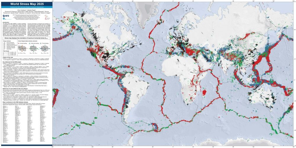
Pleased to announce the 4th major release of the @wsmproject.bsky.social, the biggest update of the database since the project began.
With thousands of new data, the 2025 WSM brings the most comprehensive picture yet of Earth's present-day stress field.
#Geomechanics
W: www.world-stress-map.org
21.05.2025 10:49 — 👍 27 🔁 12 💬 0 📌 5
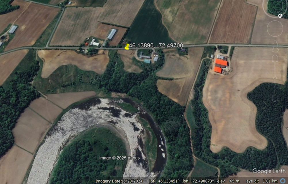
Google Earth image of the site of the 21 May 2025 quick clay landslide at Sainte Monique in Canada.
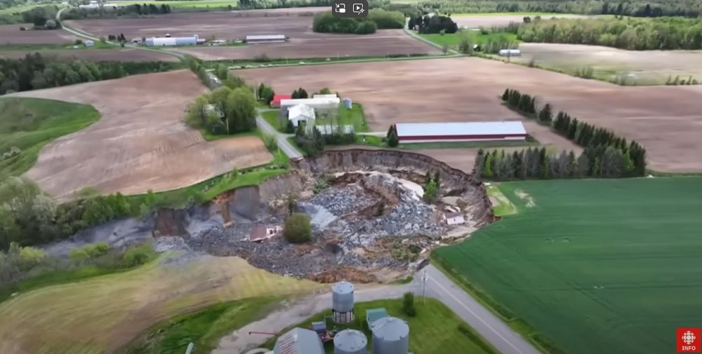
A drone image of the site of the 21 May 2025 quick clay landslide at Sainte Monique in Canada. Still from a drobe video posted to Youtube by Radio-Canada Info.
On 21 May 2025, a house was destroyed by a dramatic quick clay landslide at Sainte Monique in Quebec, Canada. Fortunately, no-one was killed:-
eos.org/thelandslide...
There is also excellent drone footage of the aftermath on Youtube, posted by Radio-Canada Info:-
www.youtube.com/watch?v=G4JB...
22.05.2025 07:07 — 👍 22 🔁 5 💬 1 📌 1
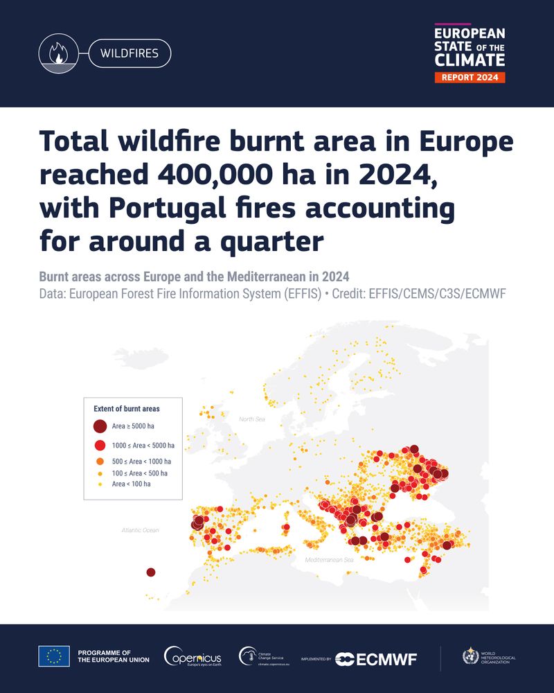
In 2024, Europe saw average to slightly above-average fire danger for most of the year, with the highest values in September. Around 110,000 hectares burnt in Portugal that month, accounting for around a quarter of the overall total burnt area in Europe for the year. bit.ly/4ctJySA #ESOTC2024 #C3S
16.05.2025 07:51 — 👍 31 🔁 20 💬 0 📌 1
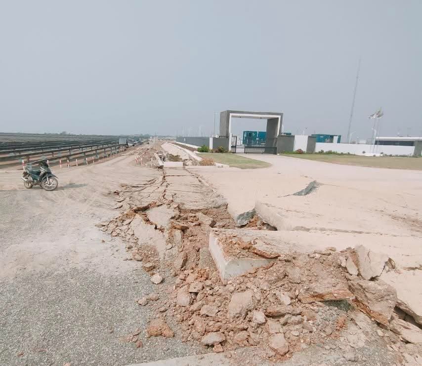
Photo of a road, the asphalt is torn apart and cracked from the bottom of the image into the distance. This is a result of an earthquake surface rupture. The road leads to a gate with white walls and some grass in front of it. Overcast sky.
This is a photo of the surface rupture we saw in the webcam footage of the Myanmar #earthquake. The webcam was positioned on the opposite side behind the gate. Source is the YouTube channel that also posted the footage. 🧪⚒️
youtube.com/@sagaingeart...
15.05.2025 17:42 — 👍 179 🔁 46 💬 3 📌 3
Incredible footage of sudden ground displacement from the recent Myanmar earthquake. It took me a few watches to understand & believe what I was seeing!
14.05.2025 10:49 — 👍 2 🔁 0 💬 0 📌 0

We hope everyone attending European Geosciences Union (EGU) 2025 has a fantastic week and don't miss the following COMET talks and posters.
You can check out the full hashtag#EGU25 programme on the EGU website www.egu25.eu
28.04.2025 09:46 — 👍 1 🔁 1 💬 0 📌 0
SEISMIC INFORMATION : SEA OF MARMARA (WESTERN TURKEY) 23 APRIL 2025 09:49
The following preliminary information is available for this earthquake:
LAT/LONG : 40.840° North / 28.142° East
DEPTH : 10 km
MAGNITUDE : 6.2 Mw
LOCALITY : Sea of Marmara, 75 km west of Istanbul, Turkey
23.04.2025 10:54 — 👍 14 🔁 8 💬 1 📌 0
BSSC2014 (Scenario Catalog)
USGS Earthquake Hazards Program, responsible for monitoring, reporting, and researching earthquakes and earthquake hazards
USGS provides interactive ground motion maps for 14 earthquake scenarios on the Elsinore fault, ranging from M 6.8 to M 7.7 (many combinations of different fault sections) so you can see what shaking it is capable of producing in the future earthquake.usgs.gov/scenarios/ca...
15.04.2025 02:22 — 👍 6 🔁 4 💬 1 📌 0
🫨 Yeah, we felt it, too.
Today's #earthquake occurred near the Elsinore Fault Zone and reached a magnitude of 5.2, according to scientists with @igpp-sio.bsky.social. You can view the seismic wavefield animation by Scripps Oceanography PhD candidate John Rekoske.
15.04.2025 00:05 — 👍 206 🔁 52 💬 10 📌 10

Earthquakes in Thailand—Is Bangkok at Risk?
This effect has been seen in Bangkok before, following events in 2007, 2011 & 2014 around northern Thailand, Laos & Myanmar. Another famous example of basin amplification was seen in Mexico City in 1985, when a quake ~350km away caused $3-4 billion USD in damage. (2/2) www.verisk.com/blog/earthqu...
28.03.2025 16:55 — 👍 1 🔁 0 💬 0 📌 0
Although the effects of today's Sagaing quake are most severe in places like Mandalay, shaking in Bangkok may seem surprising given it's ~1000km from the epicentre. This is due to long period ground motion, amplified by a deep sedimentary basin comprised of soft alluvial clay. (1/2)
28.03.2025 16:55 — 👍 3 🔁 1 💬 1 📌 1
NLL-SSST-coherence high-precision earthquake location catalog for the 2025 #Santorini #Amorgos #earthquake swarm.
Based on data from Institute of Geodynamics of the National Observatory of Athens (NOA-IG).
Download & details: doi.org/10.5281/zeno...
03.03.2025 06:37 — 👍 39 🔁 12 💬 3 📌 0
Increased likelihood
of an eruption on the Sundhnúkur crater row | News | Icelandic Meteorological office
IMO's models suggest the volume of magma accumulated beneath Svartsengi has exceeded the amount present before the eruption that began on November 20, 2024.
It is anticipated that an eruption may start in Sundhnúksgígaröð with very short warning. Below latest IMO news:
26.02.2025 11:47 — 👍 14 🔁 6 💬 1 📌 0
As would I! Many years ago during my MSc I did exactly that for seismicity leading up to the 2011 El Hierro submarine eruption, & found it was extremely useful for tracking magmatic movements & differentiating between intrusions.
12.02.2025 18:20 — 👍 1 🔁 0 💬 1 📌 0
The article doesn't address this directly, but as it states it can detect smaller magnitude events than traditional methods, I'd have thought a lower magnitude of completeness could affect b-value? An interesting question, but I'm unfortunately far more of a volcanologist than a seismologist!
12.02.2025 11:25 — 👍 1 🔁 0 💬 1 📌 0
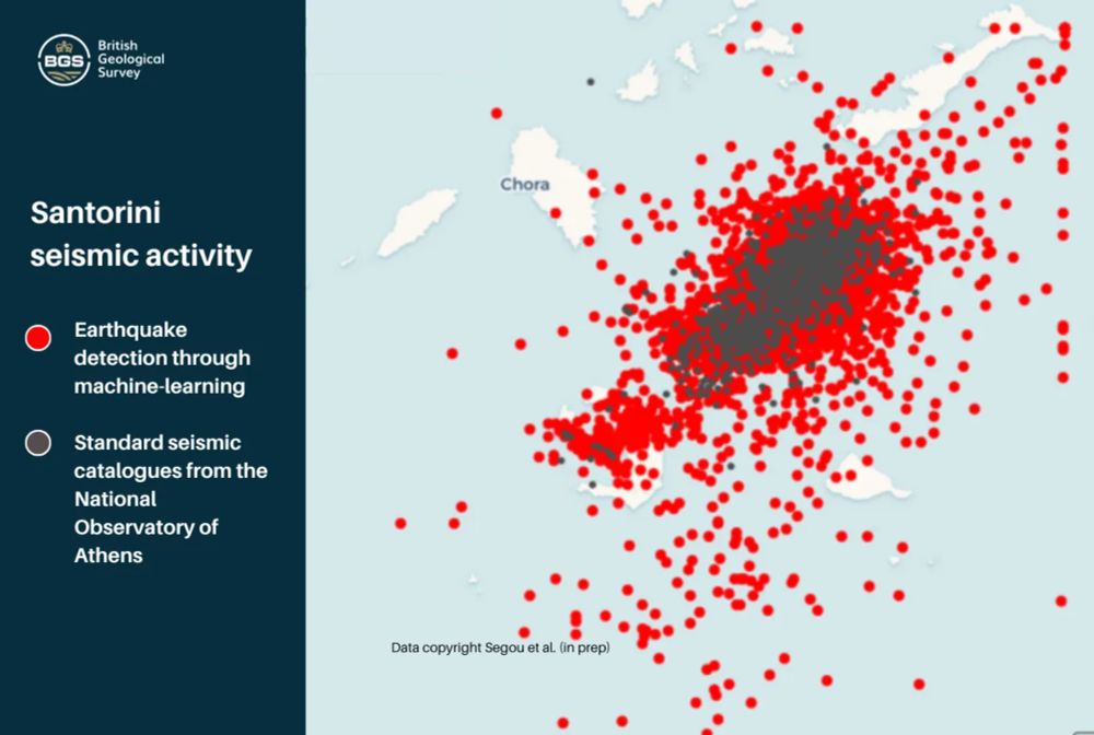
Artificial intelligence is proving a game changer in tracking the Santorini earthquake swarm - British Geological Survey
An online tool that shows which roads are most likely to cause river pollution is being expanded to assess pollution from agricultural areas.
With geoscientists keeping a close eye on the seismicity around Santorini over the past couple of weeks, this work by the BGS using machine learning to enhance detection & short-term forecasting for advising emergency services & at-risk communities is fascinating: www.bgs.ac.uk/news/artific...
10.02.2025 17:44 — 👍 9 🔁 4 💬 2 📌 1
A brilliant and comprehensive record of the volcanoes dotted around Europe, complete with their various characteristics and unique hazards to be aware of.
07.02.2025 16:09 — 👍 3 🔁 0 💬 0 📌 0
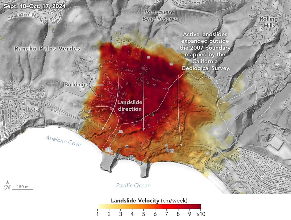
NASA Radar Imagery Reveals Details About Los Angeles-Area Landslides - NASA
Analysis of data from NASA radar aboard an airplane shows that the decades-old active landslide area on the Palos Verdes Peninsula has expanded.
NASA's UAVSAR radar has detected that parts of the Palos Verdes Peninsula in Los Angeles County are sliding toward the ocean at rates up to 10 cm per week, following heavy rainfall in 2023 and 2024.
⚒️🧪 #geology #geohazards #remotesensing
31.01.2025 22:12 — 👍 28 🔁 13 💬 0 📌 0
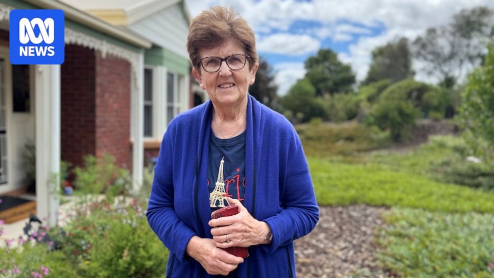
Geoscience Australia releases high-risk updated earthquake zones
Geoscience Australia says Darwin and the Latrobe Valley are more likely to experience "strong ground shaking". The latter is among the sites the Coalition has identified as a potential home for a nucl...
For context, Geoscience Australia have updated their NSHA (National Seismic Hazard Assessment) Map, and two areas have been classified as higher hazard than the previous map from 5 years earlier. These areas don't suddenly have a higher chance of earthquake activity. Hazard ratings aren't prediction
30.01.2025 04:16 — 👍 12 🔁 2 💬 0 📌 1
A podcast exploring the world of volcanoes across nature, culture and society.
Each episode featuring a new guest for their unique perspective on the world of volcanoes.
Sponsored by: Brunton, and John Wainwright and Co.
https://www.volcaknowledge.com/
Cambridge University interdisciplinary research centre dedicated to the study and mitigation of risks that could lead to human extinction or civilizational collapse.
earthquakes, volcanoes, breaking the continents
Postdoc at Swansea University researching Japanese Tephra.
PhD investigated volcanism in Afar, Ethiopia 🌋🇪🇹
Dysgwr o Gymru
Assistant Professor @Vrije Universiteit Amsterdam 🌍 Drought risk, societal impacts & adaptation modeller 🏜 Climate Justice activist @Scientist Rebellion ✊ Views my own 🚄 she/her
Rock ̵e̵t̵ ̵ scientist @durhamearthsci.bsky.social 🧪⚒️
Husband, dad, typographical errer
MP for Coventry South | coventrysouth@parliament.uk | she/her
Seismologist.
NERC Independent Research Fellow and Lecturer at University College London (UCL).
https://profiles.ucl.ac.uk/89579-stephen-hicks
Catastrophe modeling company specializing in seismic hazard and risk assessment. We serve the public, the re/insurance and ILS communities and mortgage lenders.
Researcher at UB | Assistant Prof. in Natural and anthropogenic risks at UAIC | Fascinated by vulnerability to natural hazards and vulnerability dynamics, multi-risk, multi-hazard, risk perception
Official EGU NH Division account, operated by volunteers on behalf of European Geoscience Union, providing information on Natural Hazards research. Online weekdays, European time.
PhD student researching earthquake and landslide hazard in central Asia at Oxford Uni.
Professor of Warnings & Science Communication @STSUCL, Director of @UCLWRC. Researcher of warnings, risk & uncertainty, art/sci collaborations, & volcanoes 🌋
https://profiles.ucl.ac.uk/24010-carina-fearnley
The UCL WRC is unique in bringing together global expertise to explore the role of warnings in managing vulnerabilities, hazards, threats, risks, and disasters.
http://www.ucl.ac.uk/sts/wrc
The #CopernicusClimate Change Service (#C3S) & #CopernicusAtmosphere Monitoring Service (CAMS), implemented by @ecmwf.int on behalf of the European Commission.
Social media team contact: 📧 so-me@iavceivolcano.org
Official website: iavceivolcano.org
Local political party for Southampton District, England.
https://southampton.greenparty.org.uk/
Green MP for #WaveneyValley.
Co-leader of the Green Party of England and Wales (@greenparty.org.uk) with @carladenyer.bsky.social
Former charity CEO.
Need to get in touch?
📧 waveneyvalleyoffice@parliament.uk
https://linktr.ee/AdrianRamsay
🪡Maker of Palaeoplushies™; soft realistic extinct creatures🦖🦤 (and increasingly more extant ones🐟🪲)
She/Her
Watch out for Fish!
Tumblr: palaeoplushies
Website: www.palaeoplushies.com
Commissions: No, except science communication


