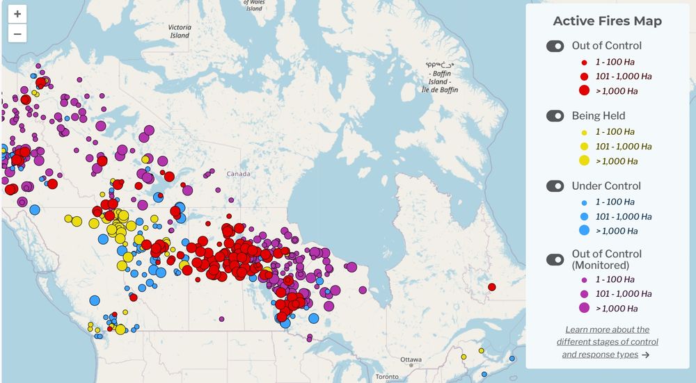
Map of Canadian wildfire location and status
https://www.ciffc.ca/

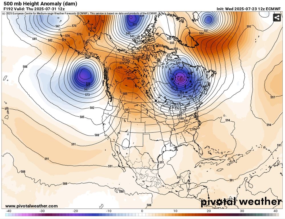
500 mb anomaly map of north america showing a ridge over Alberta and Saskatchewan
https://www.pivotalweather.com/model.php?m=ecmwf_full&p=500h_anom&rh=2025072312&fh=loop&r=na&dpdt=&mc=
🚩Potential for another fire weather/fire episode in Canada Starting next Tue-Wed (Jul 29-30) in AB then shifting to SK – MB – NWRN ON (Wed – Sat Aug 2). This is concerning as 2025 is very active fire season with 280 Out of Control fires - many in the regions mentioned. 500mb anomaly forecast below.
23.07.2025 18:20 — 👍 30 🔁 17 💬 3 📌 1
Total estimated emissions of 2025 Canadian #wildfires to 03/06 at ~50 MtC, comparable to 2023 record over same period, and increasing. #CopernicusAtmosphere Global Fire Assimilation System data based on MODIS🛰️ active fire obs ads.atmosphere.copernicus.eu/datasets/cam... @copernicusecmwf.bsky.social
04.06.2025 09:43 — 👍 47 🔁 25 💬 2 📌 6
Looking forward to tomorrow’s discussions on #ModelingWildfires and advancing #CarbonEmissions monitoring with next-gen #GeostationarySatellites. Excited to hear from Roberto Inghilesi, Mario M. Valero, Xavier Ceamanos, and Matthias Forkel!
26.11.2024 18:20 — 👍 1 🔁 0 💬 0 📌 0
Canada's 2024 wildfire season ranked as the second-worst in emissions over the past two decades, following the record-breaking 2023 season. The west experienced unprecedented emission levels, with smoke reaching as far as #Europe and significantly worsening #AirPollution. 🌍🔥
26.11.2024 18:20 — 👍 0 🔁 1 💬 1 📌 0
Key highlights:
Global #WildfireEmissions are on the rise, with #Canada experiencing record-breaking years in 2023 and 2024. In contrast, emissions in #TropicalAfrica have been declining consistently over the last two decades.
26.11.2024 18:20 — 👍 1 🔁 0 💬 1 📌 0
#EarthObservation and #Modeling are crucial for wildfire monitoring and estimating #CarbonEmissions, yet challenges persist—#EmissionFactors, fuel variability, and sensor uncertainties.
26.11.2024 18:20 — 👍 1 🔁 0 💬 1 📌 0

Day 1 of the #FutureFocus #Wildfires workshop by @eumetsat.bsky.social, which I attended virtually, was packed with incredible insights from experts like Daniela Stroppiana, Emilio Chuvieco, Mihale Pavolonis, Celia Gouveia, Mark Parrington @mparrington.bsky.social, and Laurence Rouil. 🌍🔥
26.11.2024 18:20 — 👍 11 🔁 5 💬 1 📌 0
PhD Researcher @ Uni Birmingham and Thompson Rivers Uni Wildfire 🔥formerly firefighter with the BC Wildfire Service, MAGMA Lab tech, and sci-comms with Climate Home News + DeSmog UK
Postdoctoral fellow at Colorado State University (USGS/NASA). 💧🔥🪲 Biogeochemist studying wildfire & mining impacts on water. Open science + Rstats enthusiast. First-gen 🎓 & advocate for diversity in STEM. she/her
🌐 tinyurl.com/limnologylauren
Assistant Prof. at Yale School of the Environment. Political economy of climate and environment, land use change, remote sensing, causal ML. https://sanford-lab.github.io/
Professor, scientist, mom. Chaser of wildfires and permafrost thaw. I love bogs and want you to join me.
Forest ecophysiologist and woods wanderer. Extension Assistant Professor @UVM. Forests, climate change, carbon. She/her/hers. Views my own.
Forest Climate Adaptation, Biodiversity Conservation, & Disturbance
🔥🦌🌪️🪲🌊🪱❄️ 🐛⛈️🦠🌱
IonE Postdoctoral Fellow @ Institute on the Environment, University of Minnesota
Forest ecology | remote sensing | disturbance ecology
Assistant Professor | Colorado State University | Department of Forest and Rangeland Stewardship
Researcher in forest/landscape/historical/global change ecology @UQAC & @CEF_CFR. Past and future long-term forest changes, their causes and consequences…
Forest ecologist studying forest-fire-climate interactions.
www.hurteaulab.org www.firescenter.org
PhD @ Wageningen University and Research | Previous researcher at MBZUAI (Abu Dhabi) and University of Copenhagen.
Research : Computer Vision | Representation Learning | Environmental Applications of AI (eco-conscious AI)
https://vishalned.github.io
Plant and geoscientist using drones and satellites to map spatio-temporal patterns | Working at the Center for Scalable Data Analytics and Artificial Intelligence (ScaDS.AI) and Dresden University | Previously at @iDiv, DE.
Senior Lecturer (Assoc. Prof) RHULGeography | Interested in #peatlands, #wetwoodlands, #swamps, carbon & science-policy | http://www.wetwoodlands.com | She/her
Wildfire Scientist🔥Bog Botherer🌿| King's College London - NCEO
https://bio.site/lukerf
Belize GEO: Belize Group on Earth Observation & GIS. Shares SciComm re: EO, GIS relevant to Belize, the Caribbean, and other regions. Administered by a real live Belizean scientist.
Using remote sensing for environmental conservation | Rangeland condition assessment | Adelaide, Australia
Applied Remote Sensing Lab in the Department of Geography at McGill University led by Dr. Margaret Kalacska
Professor of Machine Learning in Agriculture at University of Bonn
Working on Explainable ML🔍, Data-centric ML🐿️, Sustainable Agriculture🌾, Earth Observation Data Analysis🌍, and more...
Assistant Professor for Geoinformatics - Spatial Data Science at Trier University, Germany. Earth Observation. Remote Sensing. Geoinformatics. Data Science. Open Science.
Ecology, fire effects, fire science, climate change. Retired USFS R&D, EiC Intl J Wildland Fire 2008-2024. Green energy, politics, public policy.


