Historians use data science to mine the past | PNAS
Historians use data science to mine the past
✨✨Maps & newspaper research from LwM & MRM teams (@danielwilson.bsky.social @joshrhodes.bsky.social @jonhistorian61.bsky.social @nottinauta.bsky.social @ruthahnert.bsky.social @npedrazzini.bsky.social @kallewesterling.bsky.social + more) featured in @pnas.org this week!
www.pnas.org/doi/10.1073/...
02.05.2025 12:51 — 👍 20 🔁 11 💬 1 📌 2
As well as times based on mode of travel. Based on current ratios (still being tested against sources) this 398.48 km path from Rome to Bologna would take fast couriers at least 26 hours (~3 days), riders around 60 (~7 days), and pedestrians around 100 (~12 days).
09.05.2025 00:47 — 👍 4 🔁 0 💬 0 📌 1
The EMDigIt platform will also provide more details, such as the stops on this journey: Rome, La Storta, Isola Farnese, Campagnano di Roma, Monterosi, Ronciglione, Monti Cimini, Viterbo, Montefiascone, Capraccia, Bolsena, San Lorenzo Nuovo, Acquapendente... (etc.)
09.05.2025 00:40 — 👍 3 🔁 0 💬 1 📌 0
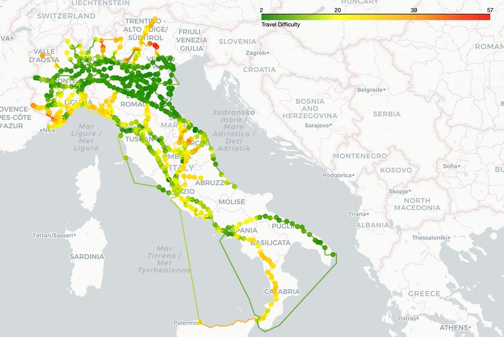
Map of Italian Peninsula with legend representing proxy measure for difficulty of travel, as shown by heat scale
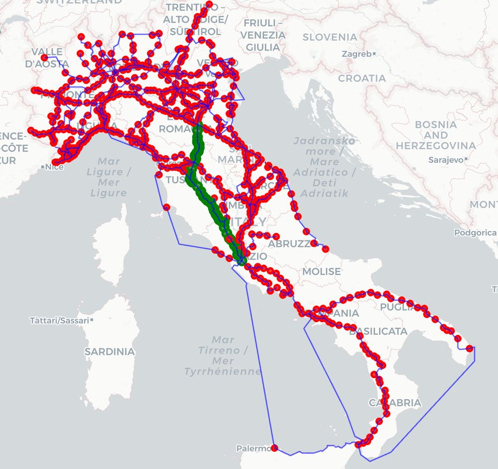
Map of Italian Peninsula with waypoints from Rome to Bologna shown in green
Two new teasers from the forthcoming Italian Itineraries data for routes in Italy, #16thc - #18thc. On the left, heat map showing difficulty of travel based on elevation and slope. On the right, shortest route by km between Rome and Bologna #earlymodern #digitalhistory 🗃️
09.05.2025 00:34 — 👍 28 🔁 7 💬 1 📌 2


Italian route network is done! 8 influential itinerary books from the #16thcentury through the #18thcentury ready for Maps-style route planning. We're on track for sharing the shapefiles in coming weeks as we continue to develop the tool. Watch this space! #earlymodern #digitalhistory 🗃️
23.04.2025 15:40 — 👍 37 🔁 17 💬 0 📌 1
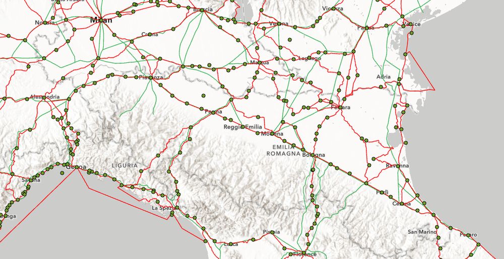
Screenshot of an ArcGIS map of northern Italy from Milan to Venice showing green waypoints and red and green paths
Probably one more session of tidying to go before I've got a complete route network for Italy as published #16thCentury - #18thCentury! I like this view of Northern Italy to show that the #earlymodern routes (red) are not just the Roman roads (green). 🗃️ @emdigit.bsky.social
08.04.2025 20:44 — 👍 74 🔁 18 💬 2 📌 0
@toffolosandra.bsky.social @flabruni.bsky.social @kaylaecampana.bsky.social @viabundus.bsky.social @geophilologist.bsky.social
01.04.2025 17:30 — 👍 6 🔁 3 💬 0 📌 0
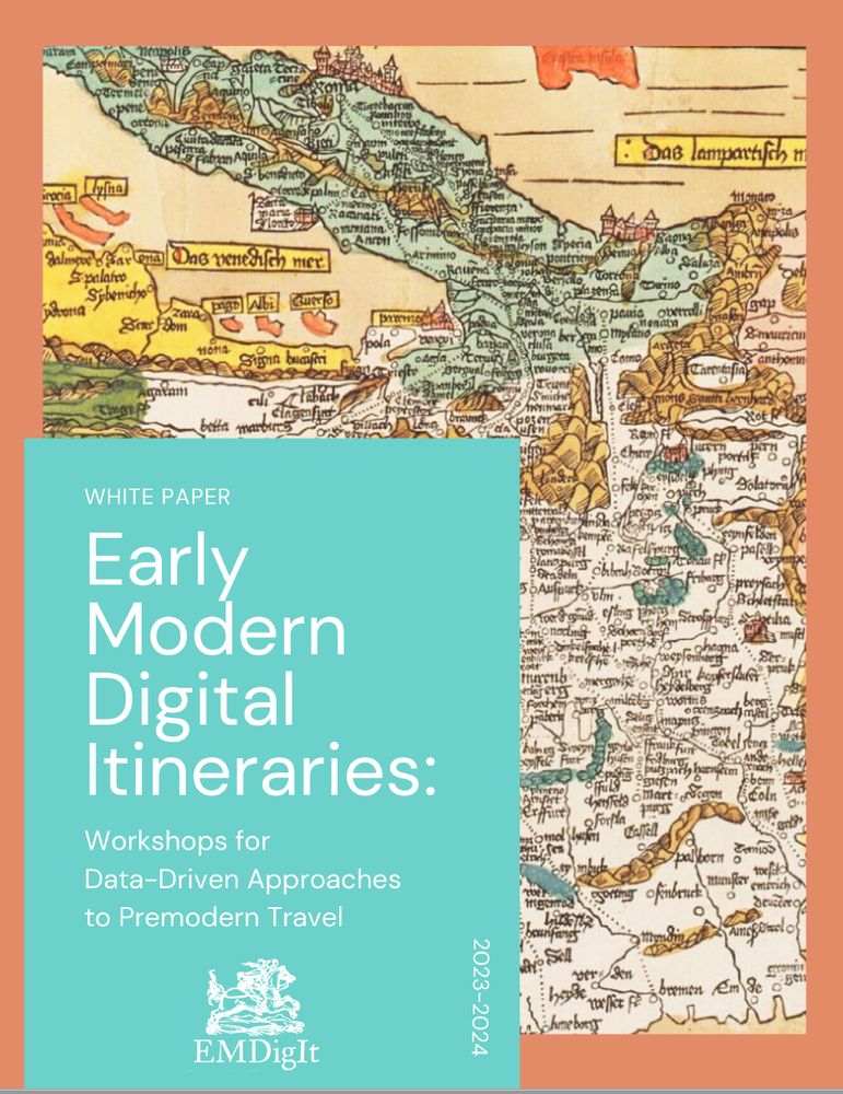
The cover of a white paper booklet titles Early Modern Digital Itineraries and featuring an early printed map of Europe
📯 New publication! 📯 We are proud to share the outcomes of our NEH workshops in 2024, which brought together researchers from around the world to pilot data-driven approaches to the history of travel 🗃️ #earlymodern #digitalhumanities #digitalhistory read more here: github.com/rmidura/EMDi...
01.04.2025 17:02 — 👍 91 🔁 41 💬 3 📌 4
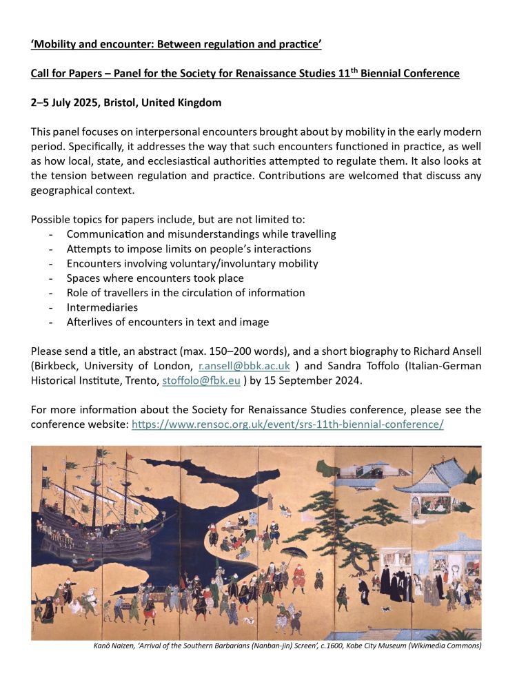
If you’re working on interpersonal encounters produced by early modern mobility, @toffolosandra.bsky.social & I are welcoming abstracts for our ‘Mobility & Encounter’ panel @srsrensoc.bsky.social in Bristol next July! Deadline 15 Sep: tinyurl.com/bdhs2hfc #skystorians #earlymodern #RenSA25
28.08.2024 08:38 — 👍 17 🔁 13 💬 1 📌 1

Screenshot of Trello board showing a number of cards related to data management and analysis with assigned student researchers shown by initials
Ended up somewhat overcommitted this semester (at least given the general environmental chaos), but it is hard to regret working with so many student researchers on @emdigit.bsky.social. Just logging in to the Trello board this morning reminded me that #digitalhumanities collaboration = community ☺️
12.03.2025 11:41 — 👍 4 🔁 1 💬 0 📌 0

A simple grey map showing routes as red lines and waystations as green dots in central Italy

A photographed page from a digitized book listing several central Italian routes in two columns
Made it to Rome, Bologna and Florence this week in #historicalGIS data cleaning for @emdigit.bsky.social. This time I'm sharing it with a page from one of the itineraries for comparison (OC1623, or Ottavio Codogno's 1623 Compendio delle poste) #earlymodern #bookhistory 🗃️
15.12.2024 21:46 — 👍 23 🔁 4 💬 1 📌 0

A simple gray map shows southern Italy from Rome to Palermo and Messina. Points reflect waystations connected by red lines reflecting likely routes.

Engraving of Giovanni de Rossi's 1695 L'Italia con le sue poste
Progressed up to the ankle of southern Italy this week. Early modern itineraries based on named locations, narrative, topography, and Roman-modern road networks. Bonus 17C map for comparison 🤩 #historicalGIS #digitalhistory @emdigit.bsky.social
07.12.2024 22:45 — 👍 30 🔁 4 💬 1 📌 0

#HelloESR, Hi #skystorians, Rome is soon entering its jubilee year, so I thought I'd talk a little about the Urbs in the 1570s through the Speculum Romanae Magnificentiae
bibliotheque-numerique.inha.fr/collection/i...
25.11.2024 12:17 — 👍 45 🔁 14 💬 1 📌 2

A screenshot shows the Veneto and Emilia Romagna regions of northern Italy in spatial analysis software
Spent the first part of today's #DayOfDH2024 in ArcGIS adjusting @emdigit.bsky.social routes (red lines) to account for elevation, Roman roads (blue lines), and locations where authors indicated crossing bodies of water (blue points) or shifting to travel by boat (icons).
02.12.2024 18:05 — 👍 24 🔁 3 💬 0 📌 0
looking forward to some mappy fun in FL! (This Thursday evening)
02.12.2024 14:51 — 👍 2 🔁 2 💬 0 📌 0
Sorry, would need a little more info to say!
01.12.2024 11:43 — 👍 0 🔁 0 💬 0 📌 0
Pilgrimage contents (by request)
#newbooks #medievalsky #skystorians #pilgrimage
30.11.2024 19:03 — 👍 39 🔁 7 💬 1 📌 2

Wireframe showing the landing page of EmDigIt, Early Modern Digital Itineraries webpage.

Wireframe showing an interactive map on the website EmDigIt, Early Modern Digital Itineraries. A left bar allows users to pose queries about travel in the style of other web map platforms.
Oops, trying again with better quality images and alt text. Haven't had my coffee yet ☕
21.11.2024 12:20 — 👍 16 🔁 6 💬 0 📌 0
We're working on it! :) @emdigit.bsky.social
21.11.2024 12:11 — 👍 506 🔁 97 💬 21 📌 6
Today's accomplishment: prepping this interactive map for Wednesday's @emdigit.bsky.social webinar showing the routing of #earlymodern Europe in Italian itineraries, 1562-1720 🗃️
12.11.2024 00:27 — 👍 18 🔁 3 💬 0 📌 0
Given the X-odus (see what we did there? A true fire bird): which other #earlymodern centres have arrived here already?
We've got a starter pack for easy following, but keen to hear about more: go.bsky.app/LLzFj3b
#skystorians
08.11.2024 09:22 — 👍 105 🔁 60 💬 3 📌 5
I have created a starter pack for scholars of the long seventeenth century! I will be adding to it; do comment or message if you would like to be added - & share!
go.bsky.app/BtkNcRq
09.11.2024 12:37 — 👍 304 🔁 138 💬 94 📌 9
GOOD NEWS for the discipline: there are *many* #earlymodern historians. Bad news: we couldn't all squeeze into one pack. So here's the second, do follow all the wonderful researchers in this one as well: go.bsky.app/NQqDFr1 #skystorians
09.11.2024 20:47 — 👍 86 🔁 45 💬 12 📌 5

Map of Europe with routes shown in four different colors
Some days you just need to put on headphones and adjust points in GIS. Route network from four different itinerary books published 1562-1610 shown here w/ borders c.1600 @emdigit.bsky.social #earlymodern #digitalhistory
07.11.2024 22:02 — 👍 83 🔁 17 💬 6 📌 1

MarineLives is launching a Collaboratory for doctoral students interested in the application of large language models to historical research #earlymodern #Skystorians @tedunderwood.me @timhitchcock.bsky.social github.com/Addaci/marin...
07.11.2024 10:21 — 👍 12 🔁 8 💬 1 📌 0
#c18 #dh 🗃️
17.10.2024 15:02 — 👍 1 🔁 1 💬 0 📌 0
They/them gay guy with a girl’s name (and now a PhD).
~Tudor-Stuart lit + neurodivergence~
🎓NRU HSE Saint Petersburg graduate student
Early Modern Italy, history of information & epidemics
Prof of Greek Literature & Culture at The Open University | working-class Classicist | still delighting in Homer | dabbling in the digital | grappling with the politics of form & linked data | Pelagios partnership sec | hello to Jason | love the show Steve
Roman Historian and Human Digitalist. Works for NYU's https://isaw.nyu.edu, but lives near Huntsville, Alabama. Editor/PI of the Pleiades gazetteer of ancient places (https://pleiades.stoa.org).
Primary social account: https://hcommons.social/@paregorios/
#digitalhumanities, #classics, ancient geographies, text alignment, #machinelearning, and #Tolkien. Yogi and coffee drinker in my spare time.
The Prize Papers Project is dedicated to the study and digitization of the Prize Papers collection stored at The National Archives, UK. It is based at the University of Oldenburg, Germany, and the National Archives, UK.
Learn more: www.prizepapers.de
The Digital Humanities Research Hub at the School of Advanced Study, University of London works to promote DH approaches, support the national DH community, and connect with DH practitioners around the world.
The Material Culture of Wills, England 1540-1790: a Leverhulme Trust project using digital tech & volunteers to transcribe 25,000 wills.
Visit our website: https://sites.exeter.ac.uk/materialcultureofwills/
This is the international viabundus-project, digitally recreating Northern Europe's route-network around 1500. 🇩🇪🇳🇱🇩🇰🇫🇮🇸🇪More on http://www.viabundus.eu
Digital historian of early modern Europe in Virginia. Posts on historical travel, mail, diplomats, spies 🕵️ Author of Postal Intelligence: The Tassis Family and Communications Revolution in Early Modern Europe (Cornell, 2025). Now on #17thC conspiracy.
Singaporean historian studying the Ottoman empire at UCLA
@OttomanChoon on twitter
Asst Prof of History/affiliate fac @chnm and GMU. Author of Civil Blood: Vendetta Violence and the Civic Elites in Early Modern Italy (Cornell UP, 2025). Co-PI of Mapping Violence in EM Italy and La Sfera. Rock climber, heavy metal enthusiast, KPop fan
Historian of mobility, space, and the circulation of people, objects, and ideas in the early modern period, particularly Venice. Works at Italian-German Historical Institute, Trento
Digital humanist; literary historian; early modernist; collaborator; feminist; parent; FEA. Queen Mary University of London: & The Alan Turing Institute, UK. She/her
Office of Digital Humanities at the National Endowment for the Humanities. Funding experimentation with technology in the humanities. Reposts ≠ endorsements.