#CaboVerde Islands Sunday-Monday.
09.08.2025 11:34 — 👍 0 🔁 0 💬 0 📌 0
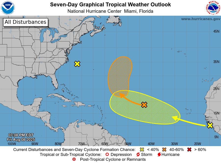
8 pm EDT - NHC is monitoring two systems over the eastern and central Atlantic Ocean. No development is expected with the system off North Carolina. See http://hurricanes.gov for details.
08.08.2025 23:17 — 👍 1 🔁 0 💬 0 📌 1
become a depression early/mid next week.
🟠 48h: 0% | 7d: 50%
08.08.2025 11:57 — 👍 0 🔁 0 💬 0 📌 0
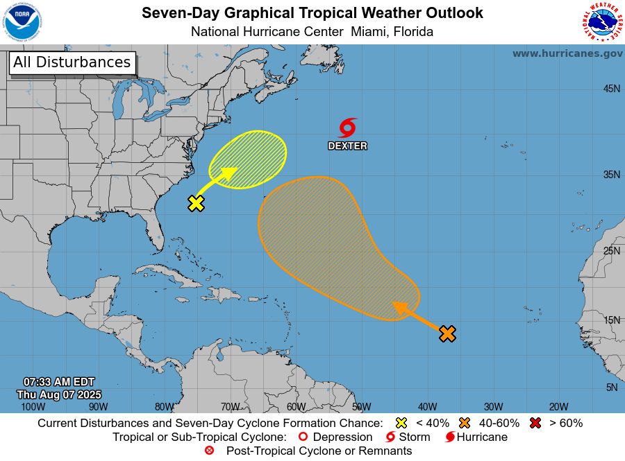
8am EDT 8/7: #Dexter and a couple of disturbances are being monitored across the basin, but none of these pose any threat to land through at least early next week.
07.08.2025 11:41 — 👍 0 🔁 0 💬 0 📌 0

8 pm EDT - In addition to Tropical Storm #Dexter, NHC is monitoring two other systems. Both of these are not expected to affect land during the next several days. Visit http://hurricanes.gov for updates.
06.08.2025 23:29 — 👍 0 🔁 0 💬 0 📌 0
Tropical Storm #Dexter Advisory 11: Dexter Strengthens a Little More. Likely to Become a Powerful Extratropical Cyclone By Friday as It Traverses the North Atlantic. http://hurricanes.gov
06.08.2025 14:44 — 👍 0 🔁 0 💬 0 📌 0
Tropical Storm #Dexter Advisory 7: Dexter Remains a Bit Weaker But Forecast to Re-Intensify as A Post-Tropical Cyclone in a Couple of Days. http://hurricanes.gov
05.08.2025 14:52 — 👍 0 🔁 0 💬 0 📌 0
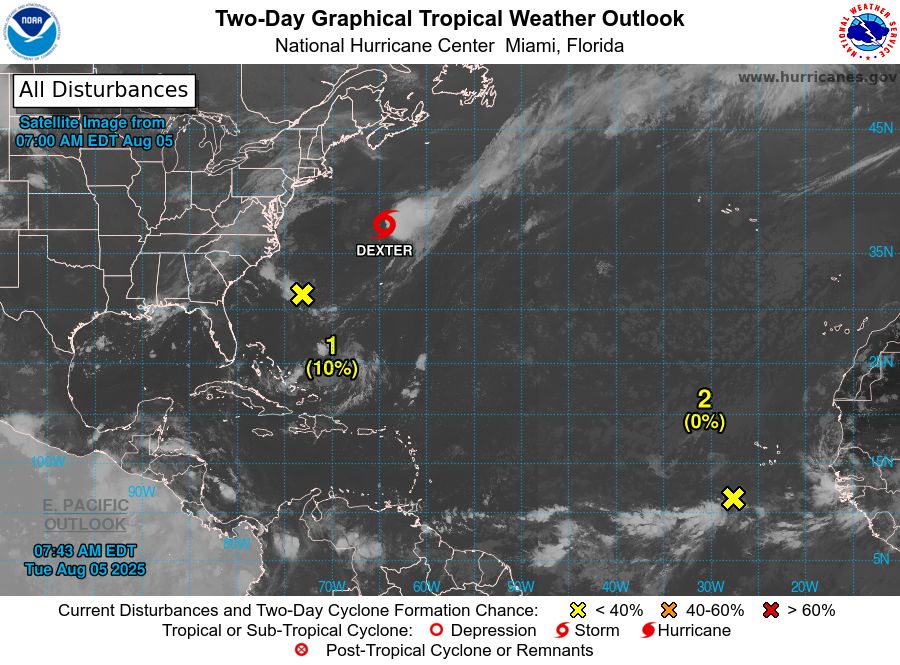
2-day tropical weather outlook probabilities overlaid on top of satellite imagery.
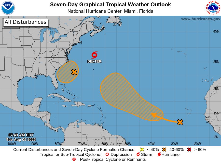
7-day graphical tropical weather outlook areas.
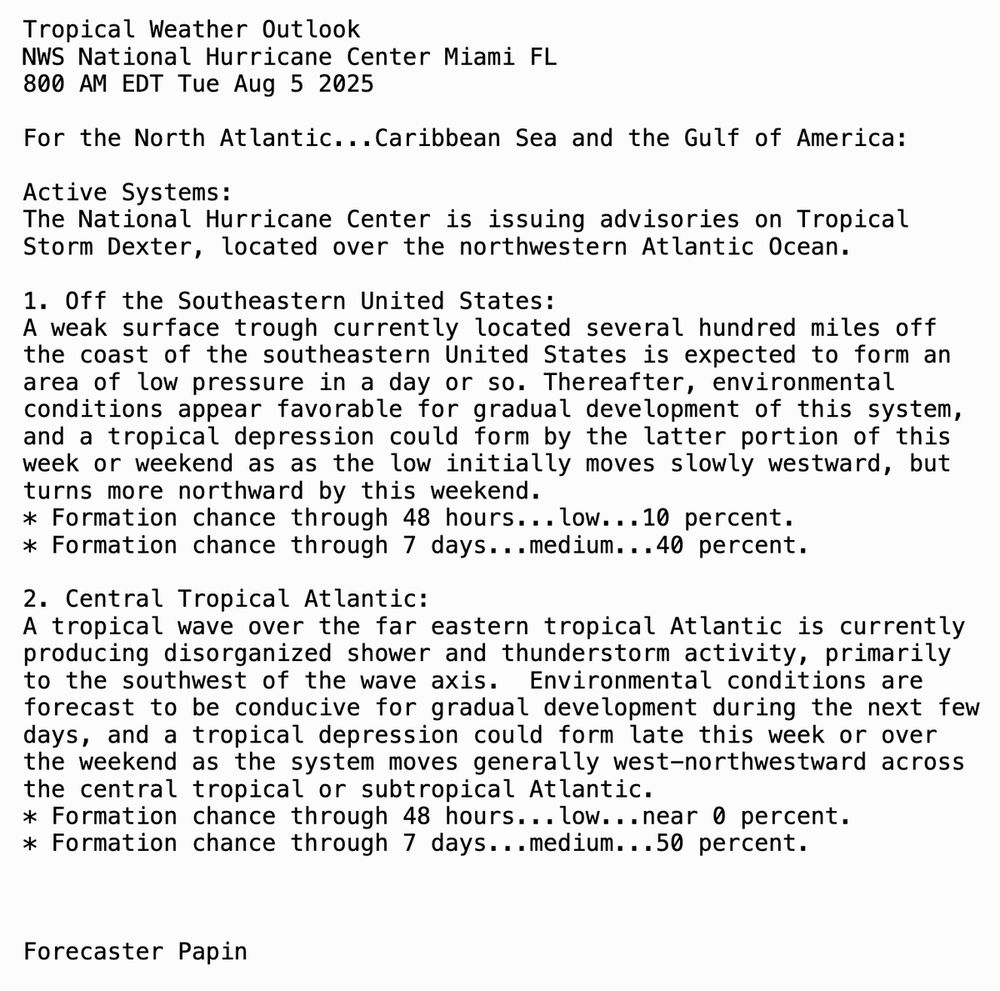
8am EDT August 5th Tropical Weather Outlook Text.
8am EDT Aug 5 - In addition to Tropical Storm #Dexter, NHC is also monitoring two areas: (1) off the southeastern U.S. coast & (2) a tropical wave off Africa.
Both have a medium chance (🟠)of tropical cyclone formation over the next 7 days.
Latest at http://hurricanes.gov
05.08.2025 14:40 — 👍 0 🔁 0 💬 0 📌 0
southeastern coast of the United States.
Monitor and for the latest tropical weather information.
04.08.2025 16:49 — 👍 0 🔁 0 💬 0 📌 0
Tropical Storm #Dexter Advisory 3: Dexter Moving Northeast Away From the U. S. East Coast With Little Change in Strength. http://hurricanes.gov
04.08.2025 14:44 — 👍 0 🔁 0 💬 0 📌 0
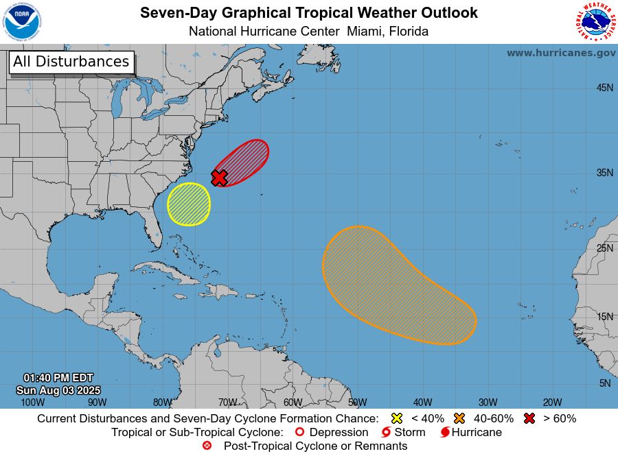
8/3 2pm- The Tropics are heating up with 3 systems that we are monitoring. #AL95 offshore of the Carolinas has a high chance of becoming a TS by Monday as it moves away from the US. Two other systems have some development potential this week- More: http://hurricanes.gov
03.08.2025 17:54 — 👍 0 🔁 0 💬 0 📌 0
coast of Africa during the next day or two, and some development is possible over the central Atlantic later in the week.
More info:
02.08.2025 23:37 — 👍 0 🔁 0 💬 0 📌 0
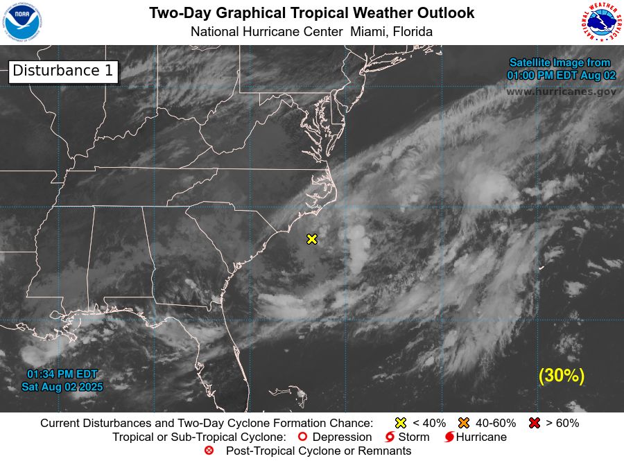
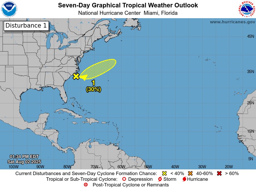
🟡 2 PM EDT Sat, Aug 2: A low is expected to form tonight or Sunday off the NC coast along a front. It has a low (30%) chance of tropical cyclone formation through Monday as it moves east-northeast away from land.
More: https://www.nhc.noaa.gov/gtwo.php?basin=atlc&fdays=7
02.08.2025 19:27 — 👍 0 🔁 0 💬 0 📌 0
prepared! August and September are typically the most active months of the season.
01.08.2025 20:59 — 👍 0 🔁 0 💬 0 📌 0
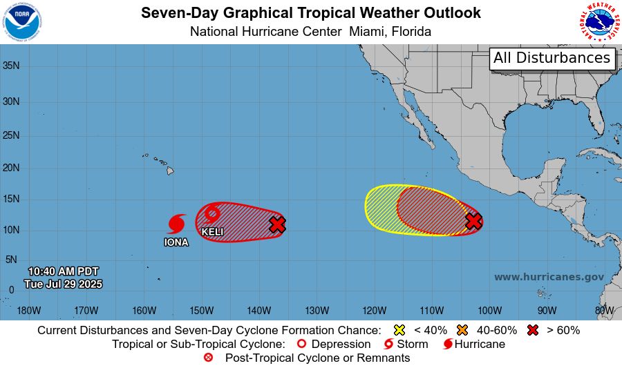
11 am PDT - The tropics are very busy over the eastern and central Pacific with Hurricane #Iona, Tropical Storm #Keli, and three potential areas for development across the region. Visit http://hurricanes.gov for details.
29.07.2025 17:45 — 👍 0 🔁 0 💬 0 📌 0
July 25 - Senior Hurricane Specialist John Cangialosi gives an update on an area of low pressure NHC is monitoring over the northwestern Gulf. Monitor http://hurricanes.gov and http://weather.gov for the latest tropical weather information.
25.07.2025 14:50 — 👍 1 🔁 1 💬 0 📌 0
tonight. Regardless of formation, locally heavy rainfall is likely over portions of the northwestern Gulf coast during the next couple of days.
25.07.2025 12:34 — 👍 0 🔁 0 💬 0 📌 0
http://hurricanes.gov/gtwo.php?basin=atlc&basin=atlc&fdays=7
23.07.2025 00:08 — 👍 0 🔁 0 💬 0 📌 0
http://hurricanes.gov/gtwo.php?basin=atlc&fdays=7
20.07.2025 23:37 — 👍 0 🔁 0 💬 0 📌 0
next week, environmental conditions are forecast to become unfavorable for further development.
See for the latest Tropical Weather Outlooks, which are issued every 6 hours during hurricane season.
18.07.2025 23:59 — 👍 0 🔁 0 💬 0 📌 0
@NHC_Atlantic on this system, but stay tuned to @NWSWPC and @NWS local offices for updates related to the ongoing risk of heavy rainfall and flooding.
17.07.2025 23:50 — 👍 0 🔁 0 💬 0 📌 0
day or two before the system moves fully inland by the end of the week.
Regardless of development, heavy rainfall/flooding is possible along portions of the northern Gulf coast, including Louisiana during the next couple of days.
Follow the latest at
16.07.2025 17:49 — 👍 0 🔁 0 💬 0 📌 0
offshore over the next couple of days.
Regardless of development, heavy rainfall/flooding is the primary hazard from central Florida westward through portions of Louisiana.
The latest Tropical Weather Outlook can always be found at
15.07.2025 23:27 — 👍 0 🔁 0 💬 0 📌 0
flash flooding over portions of Florida & the north-central Gulf coast through the mid-late part of this week.
Latest Outlook:
14.07.2025 23:47 — 👍 0 🔁 0 💬 0 📌 0
over portions of Florida and the north-central Gulf coast through the middle to latter portion of this week. Visit for your local area forecast.
14.07.2025 11:49 — 👍 0 🔁 0 💬 0 📌 0
north-central Gulf. Regardless of development, heavy rainfall could produce localized flash flooding over portions of Florida and the north-central Gulf coast this week. Visit for the latest on the rainfall potential in your area.
The latest NHC Tropical Weather Outlook can always be found at
13.07.2025 23:29 — 👍 0 🔁 0 💬 0 📌 0
week.
Regardless of development, heavy rainfall could produce localized flash flooding over portions of Florida and the north-central Gulf coast through the mid to late portion of this week. Visit for the latest on the rainfall potential in your area.
Stay up to date with the latest at
13.07.2025 17:34 — 👍 0 🔁 0 💬 0 📌 0
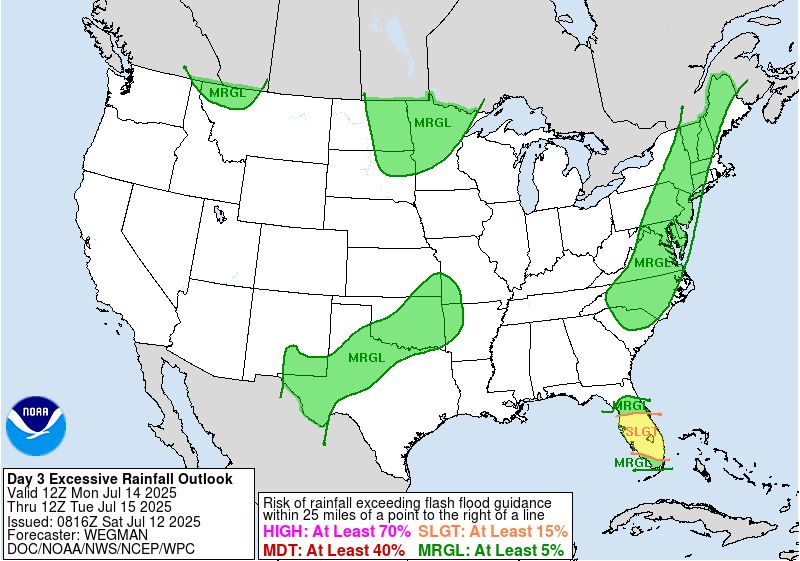
Day 3 Excessive Rainfall Outlook issued by WPC
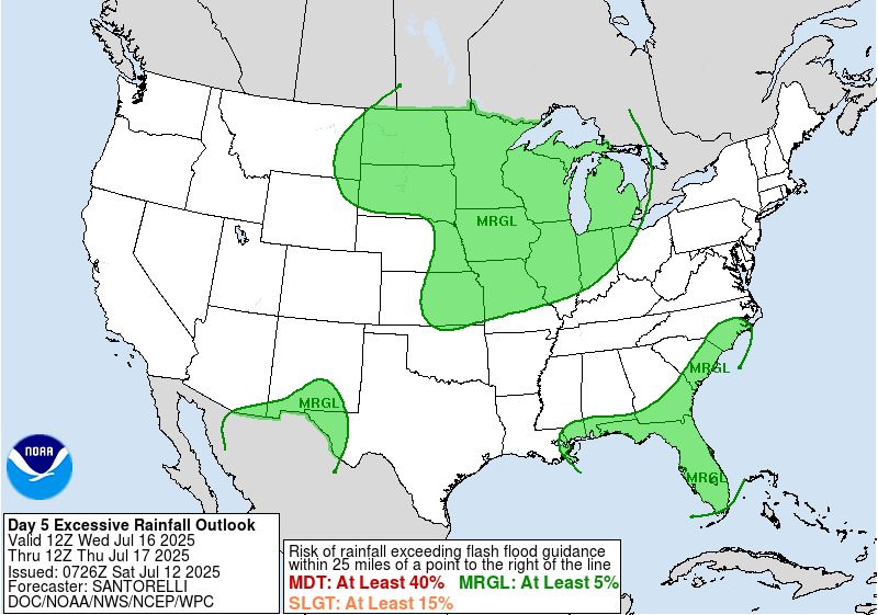
Day 5 Excessive Rainfall Outlook issued by WPC.
Regardless of TC development, heavy
rainfall is possible over parts of the Florida Peninsula and SE U.S. coast over the next week.
The most recent @NWSWPC excessive rainfall outlook highlights the risk of flash flooding in the Florida Peninsula & SE U.S. coast next week. ⤵️
12.07.2025 17:56 — 👍 0 🔁 0 💬 0 📌 0
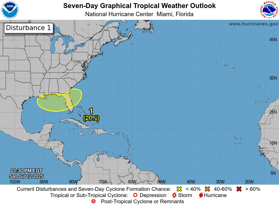
2pm EDT July 12th - An area of low pressure could develop off the SE U.S. coast & now has a low chance (20%🟡) of TC formation as it moves generally westward across the Florida Peninsula into the north-central portion of the Gulf.
Latest Outlook: http://hurricanes.gov/gtwo.php?basin=atlc&fdays=7
12.07.2025 17:47 — 👍 0 🔁 0 💬 0 📌 0
Post-Tropical Cyclone #Chantal Advisory 14: The Flash Flood Threat From Post-Tropical Cyclone Chantal Has Waned. http://hurricanes.gov
08.07.2025 02:28 — 👍 0 🔁 0 💬 0 📌 0