What's the oldest river in the world?
The oldest river predates the dinosaurs. But how do we know this?
It's interesting to think about ancient rivers... "What's the Oldest River in the World." The answer may be the Finke River in Australia (Larapinta in the indigenous Arrernte language) this waterway is estimated to be around 300-400 million years old. #hiddenhydrology
share.google/LaBcDQe0lsUs...
11.01.2026 18:22 — 👍 0 🔁 0 💬 0 📌 0

Remembering the River Bièvre
Traces of the lost river of Paris
New #hiddenhydrology substack "Remembering the River Bièvre: Traces of the lost river of Paris"
open.substack.com/pub/hiddenhy...
22.12.2025 23:16 — 👍 0 🔁 0 💬 0 📌 0
The most interesting fact I'd never read previously about related to the history of River Bièvre is that the waters were diverted in the 17th century to become one of the sources of the numerous fountains of the gardens at Versailles. #landscapearchitecture #gardens
19.12.2025 17:15 — 👍 0 🔁 0 💬 0 📌 0

The forgotten underground river that shaped Paris
Buried beneath Paris since 1912, the ghost river Bièvre shaped the French capital in unexpected ways.
Great BBC video of the River Bièvre in Paris - the lost river buried in 1912, highlighting the history, burial, and the many traces left of this #hiddenhydrology.
www.bbc.com/reel/video/p...
19.12.2025 17:15 — 👍 0 🔁 0 💬 1 📌 0
While aerial lithographs in the 1800s took significant artistic license, they provided amazing snapshots of places, with interesting detail, including hydrologic and topographic features that provide added detail to maps and narratives of the time.
15.12.2025 05:20 — 👍 1 🔁 0 💬 1 📌 0

One of my favorite images of Seattle, this 1891 image "Birds-eye-view of Seattle and environs King County, Wash., 1891" drawn by Augustus Koch and published by Hughes Litho. Co. from Chicago. #seattle #hiddenhydrology #history #maps
15.12.2025 05:20 — 👍 6 🔁 0 💬 1 📌 0

Fort Astoria, 1813
#OnThisDay in 1813, during the War of 1812, Captain William Black claimed possession of the Columbia River drainage for Great Britain. historylink.org/File/9767
13.12.2025 17:10 — 👍 4 🔁 1 💬 0 📌 0
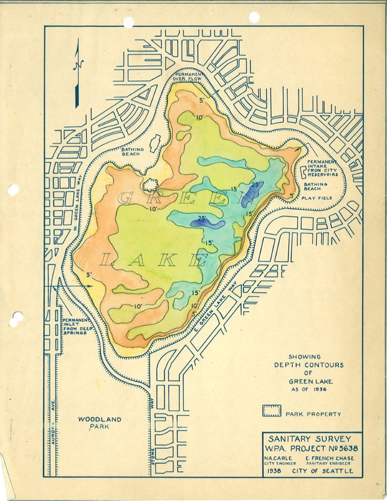
This 1938 map of Seattle's Green Lake was included in a report on algae control for the lake, conducted by the WPA. The map highlights the relative depths, or bathymetry, of the lake as colors, in 5' increments, the dark blue showing depths of around 25' depth.
#seattle #hiddenhydrology #maps
04.12.2025 16:02 — 👍 2 🔁 0 💬 1 📌 0

Seattle's topography was a constant challenge to development and expansion and multiple regrades were implemented to sluice away hillsides using high pressure water cannons. The blow image shows an example of this c1910, via
@historylink.bsky.social
01.12.2025 04:45 — 👍 1 🔁 0 💬 0 📌 0

Salmon seen in upper Bay Area creek for the first time in decades
Salmon have made their way up the largest local tributary of the San Francisco Bay.
"A layer of concrete that had previously covered the pipeline had helped block the salmon’s passage through the stream...PG&E and CalTrout wrapped up efforts to relocate the pipeline and bury it under the riverbed, allowing salmon to migrate upstream once more."
www.sfgate.com/local/articl...
01.12.2025 04:39 — 👍 0 🔁 0 💬 0 📌 0
"...Although hidden, these "ghost rivers" reveal their presence on days of heavy rain, when the drainage system cannot handle the volume, and they overflow, causing floods that paralyze the city." #hiddenhydrology #climatechange #flooding
29.11.2025 04:58 — 👍 0 🔁 0 💬 0 📌 0

Beneath the asphalt of São Paulo lies a giant hidden city, with buried rivers, secret tunnels, historical crypts, an underground subway system, and subterranean spaces that reveal an invisible and surprising metropolis.
São Paulo is known worldwide as the economic heart of Brazil, home to over 12 million inhabitants and boasting imposing skyscrapers that dominate the landscape. However, by diving a few meters below the concrete, we discover that the metropolis holds a giant hidden city, full of extraordinary secrets and forgotten corridors. What we see on the surface is only part of the story; beneath it, there is a complex universe that ensures the functioning of the capital and preserves centuries-old memories.
São Paulo "...grew over dozens of waterways that, with the rampant urbanization of the 20th century, were channeled and hidden. It is estimated that More than 300 km of waterways are buried.... famous rivers... now flow invisibly beneath busy avenues."
en.clickpetroleoegas.com.br/sob-o-asfalt...
29.11.2025 04:58 — 👍 2 🔁 0 💬 1 📌 0

Seattle Star, October 10, 1901
#OnThisDay in 1901, the City of Seattle rejected proposed boulevards along the Lake Washington Ship Canal. www.historylink.org/File/22981
27.11.2025 17:50 — 👍 2 🔁 1 💬 0 📌 0

This c1885 view of the south shore of Lake Union, (which looks a little different today as the home of Amazon) shows the Western Mill Company (right) and Queen Anne Hill across the other side of the lake. Via @historylink.bsky.social Courtesy Washington State Digital Archives (AR-07809001-ph003736)
27.11.2025 16:29 — 👍 0 🔁 0 💬 0 📌 0
Been researching tons of historical images (maps, photos and illustrations) of Seattle for the book project... (More to come on that). There are such great stories, and images really punch up the narrative. I thought it'd be fun to post some #hiddenhydrology related ones here.
27.11.2025 16:29 — 👍 1 🔁 0 💬 2 📌 1

A sepia map showing a river in middle. From “Hydrographie de Montréal au 17e siècle” from Mahaut, “Cartographie des Anciens Cours.”
Article 7: Kregg Hetherington, "The Time of Ghost Rivers" explores a ghost river in Montreal, its various revivals in the present, and the halting attempts by urban actors to form relations with it.
read.dukeupress.edu/environmenta...
26.11.2025 08:11 — 👍 5 🔁 2 💬 1 📌 1

Cartographies of Memory
Using mapping to trace historical changes in the landscape
Read my most recent post from #HiddenHydrology substack Cartographies of Memory.
open.substack.com/pub/hiddenhy...
26.11.2025 23:32 — 👍 1 🔁 0 💬 0 📌 0

Map of Washington, DC with lost streams shown.
Here's a new edition of the Lost Streams of Washington, DC map. I've added more stream names, historic springs, and the pipes that carry runoff today.
28.03.2024 16:34 — 👍 162 🔁 49 💬 9 📌 5

Detroit’s buried streams are neighborhood flooding threat
Research shows Detroit’s buried streams disproportionately impact redlined neighborhoods.
Since 1905, 85% of the Detroit's historic streams and waterways have been buried for urban development, leading to long-term ramifications for Detroit’s most vulnerable residents. www.bridgedetroit.com/detroits-gho... Ghost streams, hidden hydrology + historic redlining contribute to flooding today.
24.01.2024 18:23 — 👍 2 🔁 2 💬 0 📌 0
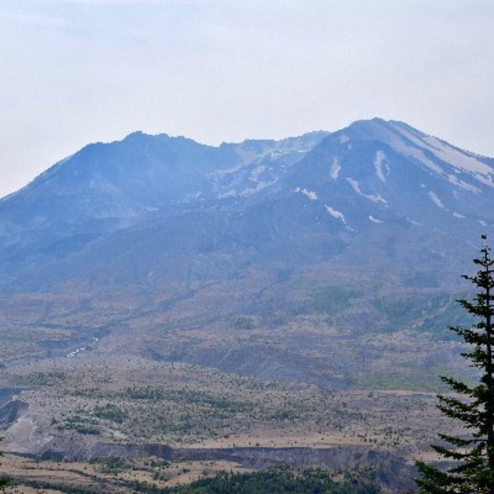
Former SciComms guy Chris here. I talk about Mount St. Helens: the calm and beauty before, all of 1980, and the land’s recovery.
About Me: https://bsky.app/profile/mountsthelens1980.bsky.social/post/3lohgbvt4ab2d
Links: https://linktr.ee/sthelensin1980
Oregon's science and culture museum. Located on the University of Oregon campus in Eugene, Oregon. State repository for archaeological and paleontological artifacts.
@mnch_uo on Instagram and @uo_mnch on TikTok.
If you're into cities and their histories, then you're into the Urban History Association!
Environmental History is an international journal dedicated to exploring the history of human interaction with the natural world.
http://environmentalhistory.net/
Acquisitions editor at University of Washington Press
Protecting Natural Resources for Everyone nwtreatytribes.org
A news service of the Northwest Indian Fisheries Commission nwifc.org
Federal-consortium partnership teaming scientists with natural & cultural resource managers to deliver science that helps fish, wildlife, water, land & people in the NW adapt to climate change. Home of @nwriscc.bsky.social. Hosted by @cig-uw.bsky.social.
PNW historian, teacher, HistoryLink writer. Union leader. Deadhead and Phish enthusiast. I like to hike and play board games.
We're a nonprofit news org dedicated to telling stories of climate solutions and a just future. Get our journalism in your inbox: https://grist.org/subscribe/
Investigative journalism in the public interest. Headlines and (sometimes literal) receipts.
Send us tips: propublica.org/tips
Architecture, landscape, urbanism. Independent nonprofit public scholarship on the built environment. Free & accessible to all.
Read: http://placesjournal.org
Sign up: placesjournal.org/newsletter
Donate: https://placesjournal.org/donate/
Official account of the world’s largest library. Explore collections & plan a visit. All Library accounts: https://loc.gov/connect
A collection of old photographs, historic newspaper clippings and assorted excerpts highlighting the parallels of past and present. http://yesterdaysprint.tumblr.com
Environmental historian. Author of Where the City Meets the Sound: The Story of Seattle's Waterfront, coming out in May 2025
AASLH provides leadership and resources to help the history community thrive and make history more meaningful to all people. Join us at aaslh.org.
Independent BC-based journalism swimming against the current. Paywall-free since 2003. support.thetyee.ca
Managing, sustaining, and protecting the health & productivity of Washington's lands and waters.
publisher, CHS Capitol Hill Seattle capitolhillseattle.com community news