omg sorry im so late to replying, I mostly use Uni Pin fineliners with nibs between 0.03 and 0.2 bc i like adding very random tiny details
20.07.2025 18:33 — 👍 1 🔁 0 💬 1 📌 0

some procrastination map drawing tonight
24.05.2025 22:41 — 👍 3 🔁 0 💬 1 📌 0

The Stormports of Coranz
A bit of an experimental one because I'm not super confident with adding text and it's mostly playing around with new brushes.
Some Lore and zoom ins below
#digitalart #art #worldbuilding #cartography #fantasyart
02.05.2025 18:02 — 👍 9 🔁 1 💬 1 📌 0
The pistons at the top are just a set of cliffs that have a tendency to move up and down slightly with the weather and the tides, hence the name and is the giant monster of the North real? who knows? I kinda just wanted to try out a map monster for once and it was slightly bigger than expected. 4/4
02.05.2025 18:02 — 👍 1 🔁 0 💬 1 📌 0
A part of Coranz is below sea level and this is seen on the south east part of the map as clifs and rock faces slowly go down towards more lush canyon of greenery. The main river is the from the sea and is salty but smaller rivers and cave systems bring freshwater into this giant canyon. 3/4
02.05.2025 18:02 — 👍 1 🔁 0 💬 1 📌 0
The jagged mountains and cliffs have created a bit of a protective barrier for Arch and Casan, as well as shipbreaker cove and as such these two cities have developed large archives and libraries and are cultural and educational hubs for the country and foreigners wanting to research and learn. 2/4
02.05.2025 18:02 — 👍 0 🔁 0 💬 1 📌 0
Some Lore:
These are the main ports from the North West of a country called Coranz, they're the main trading hubs (North and South Storm, hence the name stormports) with access to the sea and to a strip of land heading west to the western part of the country. 1/4
02.05.2025 18:02 — 👍 0 🔁 0 💬 1 📌 0
The Stormports of Coranz
A bit of an experimental one because I'm not super confident with adding text and it's mostly playing around with new brushes.
Some Lore and zoom ins below
#digitalart #art #worldbuilding #cartography #fantasyart
02.05.2025 18:02 — 👍 9 🔁 1 💬 1 📌 0
Doing some watercolour tests soon and needed some tester maps, so I made a timelapse video to try it out
#timelapse #cartography #maps
25.04.2025 00:36 — 👍 4 🔁 0 💬 1 📌 0

a blue sea covered in pockets of land. to the right are jagged mountain peaks and cliffs. an island is to the centre of the page, connected by bridges to the rest of the land. to the left are ship trade routes that lead to an archipelago and to the upper right is a cove filled with jagged rocks called shipbreaker cove

a blue sea filled with islands. the main of which, at the ventre had clifs of varying heights labeled the pistons. to the top left are some tentacles and the edge of the mouth of a large sea monster. the top has a border indicating this is the top of the map. we see shipbreaker cove at the bottom and a few cities at the base of the pistons called Losan and Mor

this image contains mostly land. a large lake named Lake Auro is at the bottom and sits at the base of a tall snow capped mountain with a hillside town called Etie. the lake connectw to a smaller one and follows a river north to the sea. a few mountains surround these lakes and a large crevasse is seen to the right with another river falling down it. to the left and bottom are some decorative aspects of the map. to the bottom is the border and vines and leaves. to the left is a north arrow with a yellow sun at the centre and beneath is a snake winding up the side of a text box like the caduceus symbol.
at the top we see a town called Casan and some forests
Working on a new map and practicing some typography, some extra flair and a map monster!
#wip #cartography #mapmonster #fantasymaps #maps #illustration
22.04.2025 17:31 — 👍 5 🔁 2 💬 1 📌 0
Been thinking about this one a lot lately
18.04.2025 19:26 — 👍 2816 🔁 1133 💬 8 📌 11

Support Em/Moss
Support Em/Moss
also working on setting up a kofi for some extra process pics and might put some digital wallpapers of my maps on there soon
ko-fi.com/mossdraws
22.04.2025 17:31 — 👍 0 🔁 0 💬 0 📌 0
a blue sea covered in pockets of land. to the right are jagged mountain peaks and cliffs. an island is to the centre of the page, connected by bridges to the rest of the land. to the left are ship trade routes that lead to an archipelago and to the upper right is a cove filled with jagged rocks called shipbreaker cove
a blue sea filled with islands. the main of which, at the ventre had clifs of varying heights labeled the pistons. to the top left are some tentacles and the edge of the mouth of a large sea monster. the top has a border indicating this is the top of the map. we see shipbreaker cove at the bottom and a few cities at the base of the pistons called Losan and Mor
this image contains mostly land. a large lake named Lake Auro is at the bottom and sits at the base of a tall snow capped mountain with a hillside town called Etie. the lake connectw to a smaller one and follows a river north to the sea. a few mountains surround these lakes and a large crevasse is seen to the right with another river falling down it. to the left and bottom are some decorative aspects of the map. to the bottom is the border and vines and leaves. to the left is a north arrow with a yellow sun at the centre and beneath is a snake winding up the side of a text box like the caduceus symbol.
at the top we see a town called Casan and some forests
Working on a new map and practicing some typography, some extra flair and a map monster!
#wip #cartography #mapmonster #fantasymaps #maps #illustration
22.04.2025 17:31 — 👍 5 🔁 2 💬 1 📌 0
been pretty inactive on here lately sorry, I've been off grid for a bit and haven't had time to work on much. some new process pics tomorrow of the latest lil experiment as an apology
21.04.2025 23:27 — 👍 1 🔁 0 💬 1 📌 0
might put some of my maps as phone/desktop wallpapers on my kofi soon, if I manage to figure out how to do so
21.04.2025 14:15 — 👍 0 🔁 0 💬 0 📌 0

A large tropical islands, with a central, tall volcano with some smoke coming from the top. The image is labelled Rumblecusp and at the bottom there is text. There are numbered labels on the island that correspond with a key that show Ruins, waterfalls, hot springs, mysterious portals and a village.
The text at the bottom reads:
'The Island of Rumblecusp is found to the
South Of Wildemount; a tropical location home to a vast array of exotic flora and fauna as well as planar shards. These shards were thought to be brought to the island when the Morkoth, Vokodo escaped the Astral Sea and from the Aeorian ward, Cognouza, crashing within the volcano and claiming the island as his own. He caused mass amnesia to the inhabitants of the island in order to persuade them to bring him their wealth and trap them upon Rumblecusp.
Vokodo was defeated by the Mighty Nein and
Vilya of the Air Ashari who helped shepherd those of the community who no longer wished to stay, back to their homes. Vo is still a strong
community and welcomes travelers of all kinds.
Some dangers found on and around Rumblecusp include, but are not limited to: Dragon Turtles, Draegloths', Bodak', Dinosaurs, Torchblooms, Displacer Beasts, Treants (undead), Will-O-Wisps and Mosquitoes.'
Finally finished my Rumblecusp Map/diagram?? It took a while, but I'm pretty happy with where it ended up and I think I might have to do another one for Darktow or Eiselcross soon
@criticalrole.bsky.social
#criticalrolefanart #criticalrole #digitalart #art #conceptart #environmentart #fantasyart
06.04.2025 22:39 — 👍 31 🔁 5 💬 2 📌 0
Thank you so much! I did eventually correct the Astral sea mistake so now it's actually lore accurate
07.04.2025 09:27 — 👍 1 🔁 0 💬 0 📌 0
I'll probably make a timelapse/gif or something soon because it took an ungodly amount of time to draw (enough time to rewatch the entire rumblecusp arc and then some). But I've learnt a lot of new stuff and tips and tricks for digital art.
There are some zoom ins and the island by itself on IG
06.04.2025 22:39 — 👍 0 🔁 0 💬 0 📌 0
A large tropical islands, with a central, tall volcano with some smoke coming from the top. The image is labelled Rumblecusp and at the bottom there is text. There are numbered labels on the island that correspond with a key that show Ruins, waterfalls, hot springs, mysterious portals and a village.
The text at the bottom reads:
'The Island of Rumblecusp is found to the
South Of Wildemount; a tropical location home to a vast array of exotic flora and fauna as well as planar shards. These shards were thought to be brought to the island when the Morkoth, Vokodo escaped the Astral Sea and from the Aeorian ward, Cognouza, crashing within the volcano and claiming the island as his own. He caused mass amnesia to the inhabitants of the island in order to persuade them to bring him their wealth and trap them upon Rumblecusp.
Vokodo was defeated by the Mighty Nein and
Vilya of the Air Ashari who helped shepherd those of the community who no longer wished to stay, back to their homes. Vo is still a strong
community and welcomes travelers of all kinds.
Some dangers found on and around Rumblecusp include, but are not limited to: Dragon Turtles, Draegloths', Bodak', Dinosaurs, Torchblooms, Displacer Beasts, Treants (undead), Will-O-Wisps and Mosquitoes.'
Finally finished my Rumblecusp Map/diagram?? It took a while, but I'm pretty happy with where it ended up and I think I might have to do another one for Darktow or Eiselcross soon
@criticalrole.bsky.social
#criticalrolefanart #criticalrole #digitalart #art #conceptart #environmentart #fantasyart
06.04.2025 22:39 — 👍 31 🔁 5 💬 2 📌 0
holy moly indeed, it took so long
31.03.2025 15:06 — 👍 1 🔁 0 💬 0 📌 0
I think its back to some more typical maps for a minute to recover
29.03.2025 21:34 — 👍 0 🔁 0 💬 0 📌 0

it took forever but rumblecusp is finally done. need to glaze it and do some other edits before it'll be an actual post but it's finally done
#criticalrolefanart
29.03.2025 21:34 — 👍 15 🔁 2 💬 2 📌 0
yeah the mountain felt like it made a lot more sense when I added them, but im not excited to render them, theyre going to be so annoying
21.03.2025 23:06 — 👍 1 🔁 0 💬 1 📌 0
thank you! the form and levels were tricky but I think that's roughly what hot springs look like
19.03.2025 10:48 — 👍 1 🔁 0 💬 1 📌 0
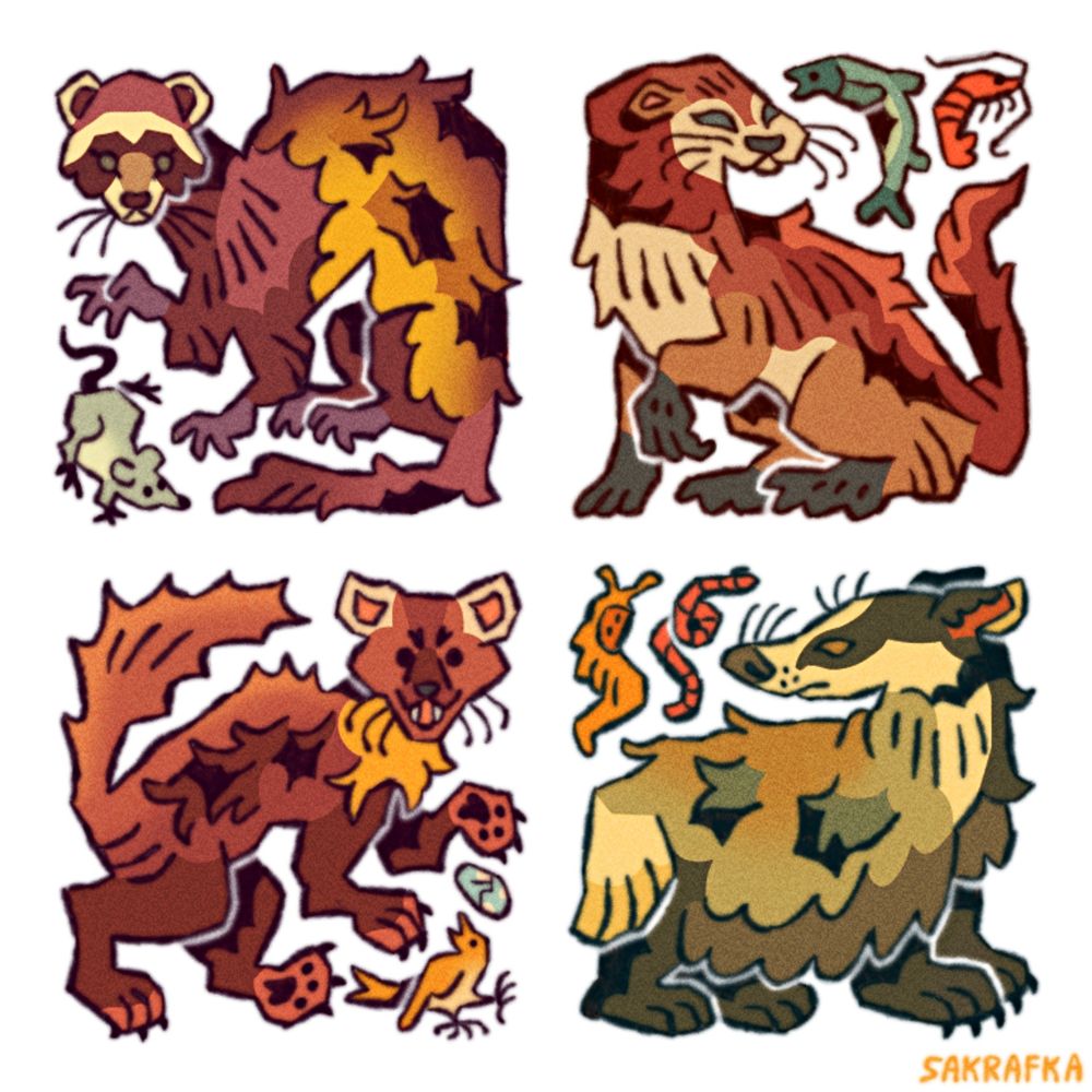
digital drawing of 4 of the european mustelid species, all of them heavily stylized to fit into a square shape
european mustelids
#art
18.03.2025 20:01 — 👍 1989 🔁 539 💬 11 📌 3

These are the main guesses for now, but im probably way off target. Its been really fun figuring this island out so thank you for creating such an interesting setting
18.03.2025 23:57 — 👍 3 🔁 0 💬 0 📌 0
@matthewmercer.bsky.social
On the off chance you see this, I've got a question about rumblecusp.
I've been drawing the island, using deven rue's map as a reference and can't really figure out the whereabouts of the village even whilst rewatching and was hoping you might shed some light on it.
18.03.2025 23:57 — 👍 3 🔁 0 💬 1 📌 0
got 90% through doing the lineart for a map before I realised I hadn't accounted for or added any trees/forests at all
...
*sigh*
guess I'm going to add some lore about why there are no trees on this island because I really don't have the patience to add them and edit everything digitally right now
16.03.2025 01:34 — 👍 0 🔁 0 💬 0 📌 0

today's agenda:
trees and hot springs... theyre real annoying to figure out but we're getting there
#wip #digitalart
13.03.2025 00:58 — 👍 4 🔁 0 💬 1 📌 0
✦Illustrator✦Storyboard Artist✦she/they✦28✦🏳️🌈 ✦🇷🇸
French #mapmaker for hire. Games, #rpg and #novels. (Games Workshop,Mnémos Editions,Ghostfire Gaming,Robert Laffont,Studio Deadcrows...) COMMISSIONS OPENED - NO NFT - NO AI
https://wheretofind.me/@thomrey
✉️ thomrey@hotmail.com
#cartography #jdr #fantasy
Fantastical Geographic & Rue Adventuring Co.~ Professional fantasy cartographer ~ queer, partially blind, artist, aggressively creative, she/they ~ Cartographer for Critical Role, MtG LotR, & others ~ No GenAI ~ No NFTs ~ https://devenrue.com/
comic creator • he/him • private commissions closed • no reposting or referencing please • check link for inquiries
https://linktr.ee/m_maf_f
The world’s most beloved digital artist
www.angelarium.net
Hi!! I'm Renee and I draw and make stuff! 💕
🌱 My Shop & Links: spicymochi.carrd.co
The home of storytelling around the table! From our Campaign 4 saga in Aramán to Daggerheart and beyond - join the actual play adventure on Beacon.tv, YT, & Twitch
Senior Producer at Critical Role, Creator & Designer for Queen By Midnight, Writer, Comedian. 🏳️🌈🏋️♂️🎲🐉
It’s chaos, be kind
Help my neighbors Greg & Cynthia after Eaton Fire! https://gofund.me/117e2bc4
Axolote Gaming founder, Creative Director Draco Studios, Wizkids sculptor, freelance sculptor, miniature enjoyer and rpg amateur writer/enthusiast!
any pronouns
| Concept Artist | Freelance Artist | EN FR | COMMISSIONS CLOSED
TTRPG and Lore nerd
contact: TheLyadrielle@gmail.com
concept/comic artist, a doodler, a mimic 🌵| she/they | 28 | 🇵🇱
✨Token Artist at @czepeku.bsky.social
https://kaawro.carrd.co/
Artist, DM, illustrated woman, she/her, agent of chaos. Wildmage Press, Critical Role, EXU, MCDM. Hello!
Kooks • they / them • PhD • illustrator
coupleofkooks.myportfolio.com
"I like beautiful melodies telling me terrible things"
Fantasy Cartographer - Wizards of the Coast, Critical Role, Darrington Press, Cosmere RPG...
Portfolio - https://cara.app/marcomaps
Inquiries - marcomapscartography#gmail.com
Poly&Pan 🏳🌈 He/They - 🏳⚧ Trans Safe Space
Fuck GenAI&NFT🚫
Friends call me Juno | he/they 🏳️⚧️🏳️🌈 | freelance artist | Scotland
Portfolio: galacticjonah.com
Everything else: galacticjonah.carrd.com
Project inquiries via email please ✨
📩galacticjonah@gmail.com
Common art tags: #originalart | #ocart
Hi, hello. A place where I can doodle/talk whatever is in my brain. Also a place where I post occasional 🔞arts
Follow at your own risk :)
Main bsky: @jquarze.bsky.social
(ON HIATUS)
Artist, classic car enthusiast, recovering as the MIA friend in the group chat