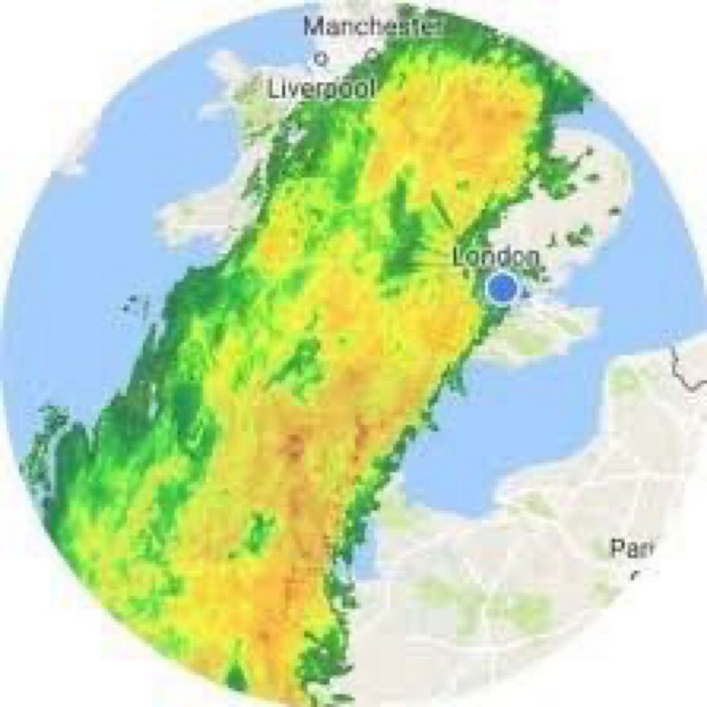
A huge question mark over Storm Darwin - 12 February 2014
Credit Eumetsat

@weatheire.bsky.social
Weather news, views and forecasts from Ireland. www.weatheire.com
A huge question mark over Storm Darwin - 12 February 2014
Credit Eumetsat


Twelve years ago today, Ireland was picking up the pieces after a sting jet developed as Storm Darwin approached the Clare coast. The roar generated by the strongest winds was unforgettable at my location in Clare. Shannon recorded a gust of 156 km/h.
12.02.2026 16:36 — 👍 1 🔁 0 💬 1 📌 0Next week, Atlantic systems will approach from the southwest, with a chance of some high-ground snow on Tuesday evening into Wednesday, particularly in the north and west. Sleet and cold rain elsewhere.
11.02.2026 18:43 — 👍 0 🔁 0 💬 0 📌 0

A blast of cold weather from Friday through Saturday night will be followed by a slight rise in temperatures. Rainfall extending countrywide will mark the beginning and end of the two-day cold snap, with some dry and sunny spells in between.
11.02.2026 18:43 — 👍 0 🔁 0 💬 1 📌 0
Anticrepuscular rays over County Clare - dark bands caused by the low sun angle and the height/structure of the cloud deck.
10.02.2026 22:21 — 👍 2 🔁 0 💬 0 📌 0
What has seemed like an unending period of single-digit temps since Christmas has been broken, with Valentia recording 12°C (13°C yesterday). Rain and overcast conditions are set to continue, however, with a return to colder conditions from late Thursday through Sunday morning.
10.02.2026 11:23 — 👍 0 🔁 0 💬 0 📌 0


After an exceptionally wet January, some eastern weather stations have recorded more than half of their average February rainfall in the first 5 days of the month. Phoenix Park has reached 66% of its monthly average. The west has remained largely dry.
"The Sunny southeast"🙄
Some temporary relief is expected for flood-hit areas of Leinster this weekend. More widespread rain will then move across the country from Tuesday through Thursday. Turning colder everywhere by Friday, with below-average temperatures likely into next weekend.
06.02.2026 14:13 — 👍 0 🔁 0 💬 0 📌 0

Two earthquakes have been recorded in the Irish Sea over the past week, measuring 1.1 magnitude and 0.7 magnitude. The quakes occurred at depths of between 7 and 12 km, approximately 45 km off the coast of Wicklow town.
05.02.2026 22:34 — 👍 4 🔁 2 💬 0 📌 0Some coastal flooding at high tide between Sandycove and Dún Laoghaire in Dublin.
05.02.2026 15:19 — 👍 2 🔁 0 💬 0 📌 0


Met Éireann has introduced a Status Orange rainfall warning for Waterford and Wicklow. More than two inches of rain could fall on higher ground (Comeraghs / Wicklow Mts) on Thursday.
04.02.2026 19:47 — 👍 0 🔁 0 💬 0 📌 0
The next 10 days look generally unsettled across Ireland, but with much lower rainfall totals than those seen over the past 10 days. Despite this, ground conditions will remain waterlogged in all areas.
04.02.2026 08:19 — 👍 0 🔁 0 💬 0 📌 0


Temperatures ranging from 2c to 10c across Ireland, with some sleet and wet snow currently falling on higher ground in Ulster. It feels a lot colder than air temps suggest due a significant wind chill effect.
03.02.2026 17:07 — 👍 0 🔁 0 💬 0 📌 0
The side of the Cruagh Road near Tibradden Wood in the Dublin Mountains subsided today, most likely due to saturated ground conditions.
03.02.2026 10:49 — 👍 1 🔁 0 💬 0 📌 0
Exceptionally, near record-breaking low temperatures across central and northern Florida today. With such deep cold filtering that far south, it's no wonder the jet stream is so fired up and delivering Atlantic system after system toward Ireland and Britain
01.02.2026 13:47 — 👍 1 🔁 1 💬 1 📌 0Rain has pushed into the southeast and will impact much of Leinster, E Munster and E Ulster through Saturday morning. A Status Yellow warning is in place for Carlow, Dublin, Kilkenny, Louth, Wexford, Wicklow and Waterford, as well as Antrim, Armagh, Down, Fermanagh, Tyrone, Derry
30.01.2026 14:07 — 👍 1 🔁 0 💬 0 📌 0

The ECM ensemble mean suggests a SE/E airflow developing in around 7–10 days, with Atlantic systems active to our S/SW. This is similar to pre-Christmas, when a succession of low-pressure systems eventually slipped away to the south, allowing a colder, drier airmass to take hold.
30.01.2026 12:50 — 👍 1 🔁 0 💬 0 📌 0It's unlikely we'll see sustained dry weather or a cold spell until after the first week of Feb. The jet is being strengthened by persistent cold across the eastern half of North America, keeping Atlantic systems active. Some easing of the cold in the US by second week of Feb.
29.01.2026 20:12 — 👍 0 🔁 0 💬 0 📌 0
Dublin has been added to the list of counties under a Rainfall Warning
28.01.2026 15:09 — 👍 0 🔁 0 💬 0 📌 0


Separate Status Yellow rainfall warnings have been issued for the southeast and northeast for Thursday&Friday respectively. Spells of heavy rain may lead to transport disruption and localised flooding, particularly where ground conditions are already saturated or waterlogged and rivers are swollen.
28.01.2026 14:41 — 👍 0 🔁 0 💬 1 📌 0


With high-latitude blocking likely in early Feb, operational runs are converging on a signal for colder conditions developing around day 10. However, with deep cold forecast over the US driving a strong jet stream, & mixed ensemble support, confidence in this outcome remains low.
28.01.2026 09:14 — 👍 0 🔁 0 💬 0 📌 0
Even the barometer is feeling low about today's weather.
Incidentally, the lowest Mean Sea Level Pressure (hPa) record for Ireland in January is 936.6 hPa, set at Markree in Sligo on Jan 26th 1884. #StormChandra bottomed out at around 959 hPa in Cork and Kerry.
A 120 kmh gust has been recorded at Malin Head in the past hour as rain, turning to snow on high ground in Ulster and north Connacht, continues to feed north. Wind gusts reaching over 140 kmh in western Scotland. Thousands remain without power across Ireland.
#StormChandra

#StormChandra has been named with Status Yellow rainfall alerts in place for 15 counties and an Amber wind warning for Antrim Down and Derry.
www.met.ie/warnings-tom...

As long as cold air remains firmly entrenched over the eastern half of the United States, the current weather pattern affecting Ireland is highly likely to persist.
weatheire.com/news/climate...
Bands of rain are wrapped around the centre of a slack low-pressure system currently positioned over the east coast. Dry spells will develop across the western half of Ireland during Sunday.
24.01.2026 23:52 — 👍 0 🔁 0 💬 0 📌 0A small risk of rain turning to snow on high ground from Tuesday evening through Wednesday morning.
24.01.2026 00:12 — 👍 0 🔁 0 💬 0 📌 0particularly in elevated areas of the northern half of Ireland. It will be cold rain for most however. Precip totals are forecast to be well above normal, and with soil conditions already close to saturation in all areas, there is an increasing risk of localised flooding.
2/2

With moderate winds at times, it will feel cold over the next 10–14 days. Temps will be slightly below normal, and with a colder pool of air to our N&E, subtle changes in the track of Atlantic low-pressure systems could give rise to a risk of sleet and wet snow developing...
1/2


Overnight model runs point toward chilly, wet and, at times, windy weather, with the prospect of calmer, drier and colder conditions now looking unlikely over the next 10 days. Incidentally, it was on this date 13 years ago that a not-dissimilar synoptic setup was in place.
21.01.2026 11:40 — 👍 0 🔁 0 💬 0 📌 0