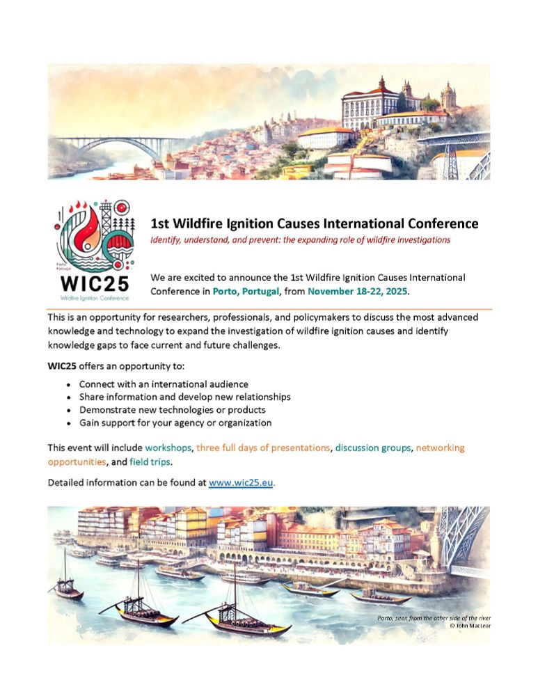
Deadline extended until June 29th!
1st Wildfire Ignition Causes International Conference, 18-22 November, Porto, Portugal wic25.eu

@aprados1.bsky.social
Scientist @UMBC working at the intersection of #disasters #risk #wildfires #airquality and #remotesensing
Deadline extended until June 29th!
1st Wildfire Ignition Causes International Conference, 18-22 November, Porto, Portugal wic25.eu
Vivir donde el fuego siempre vuelve. www.agenciasinc.es/Reportajes/V... @evarodnieto.bsky.social #DRR #disaster #disasters #DisastersAreNotNatural #DisastersAvoided #resilience #vulnerability #DisasterRisk #wildfire #Smoke #Wildfires #incendio #forestales
09.06.2025 14:17 — 👍 2 🔁 1 💬 0 📌 0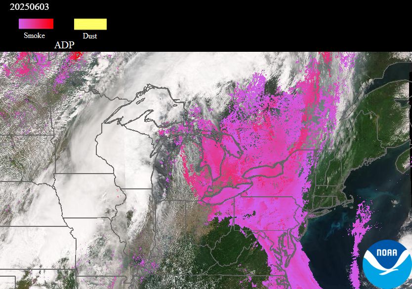
Aerosol detection (ADP) from the VIIRS sensor on the @noaa.gov SNPP & NOAA-20 satellites shows thick smoke (lavender/magenta shading), transported from the Manitoba wildfires, over southern ON/QC & NY, PA, NJ, DE, MD, VA & DC yesterday 3 Jun, causing hazy skies & vivid sunsets.
04.06.2025 12:51 — 👍 7 🔁 2 💬 0 📌 0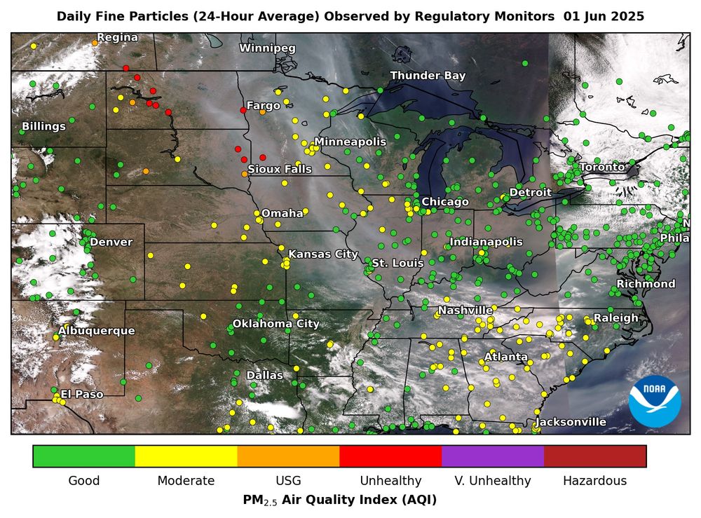
(1/2) Manitoba wildfires' smoke extended from the US Plains to the Southeast on 1 Jun, observed by VIIRS on the @noaa.gov NOAA-20 satellite. The smoke degraded daily PM2.5 air quality along its path (yellow dots), with the worst conditions in ND, SD & MN (red/orange dots). @avoiland.bsky.social
02.06.2025 14:54 — 👍 6 🔁 2 💬 1 📌 0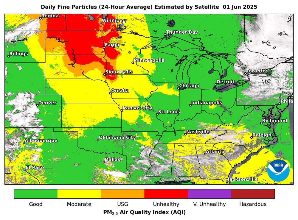
(2/2) Daily PM2.5 air quality estimated from observations of the VIIRS sensor on @noaa.gov satellites shows the full surface impacts of the Manitoba wildfires' smoke in the eastern US on 1 Jun, filling gaps in the PM2.5 regulatory monitor network, especially in rural areas. @avoiland.bsky.social
02.06.2025 14:54 — 👍 3 🔁 5 💬 0 📌 0Hello Bluesky! We are excited to join this community! We post satellite observations of global aerosol and air quality events, including wildfires, dust storms, and haze. We focus on NOAA geostationary & polar-orbiting satellite products, but also feature TEMPO and TROPOMI imagery as well.
04.02.2025 16:45 — 👍 27 🔁 5 💬 2 📌 0Disasters Avoided Newsletter #6 with @ilankelman.bsky.social and Gareth Byatt: the role of businesses in disasters
#Business #Resilience #dana #valencia
#DisastersAvoided #DRR #DisasterRiskReduction
#DisasterRiskManagement #DisastersAreNotNatural
#disaster #disasters
mailchi.mp/7e8b9620e835...
Just published with Gareth Byatt and @ilankelman.bsky.social Collective Action on Resilience (page 18) issuu.com/irmglobal/do...
08.12.2024 23:00 — 👍 4 🔁 1 💬 1 📌 0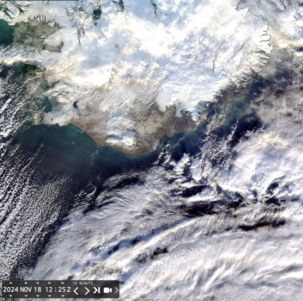
🧪🛰️🛠️
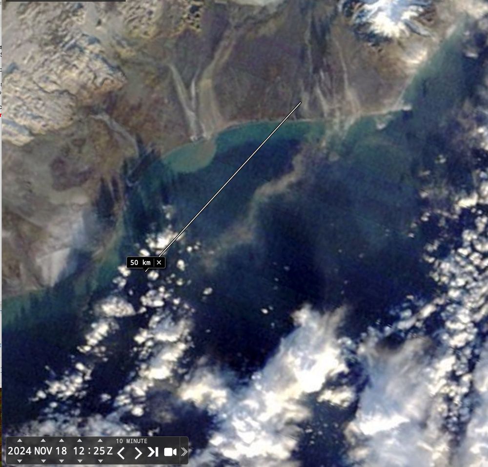
Yesterday , in #Iceland #highlatitudedust activity in the southern coast, a thin , long but thick dust plume is visible in MODIS image.
In fact there was a good #Landsat overpass , so it is nice to compare the different information provided at different spatial resolutions
1/2
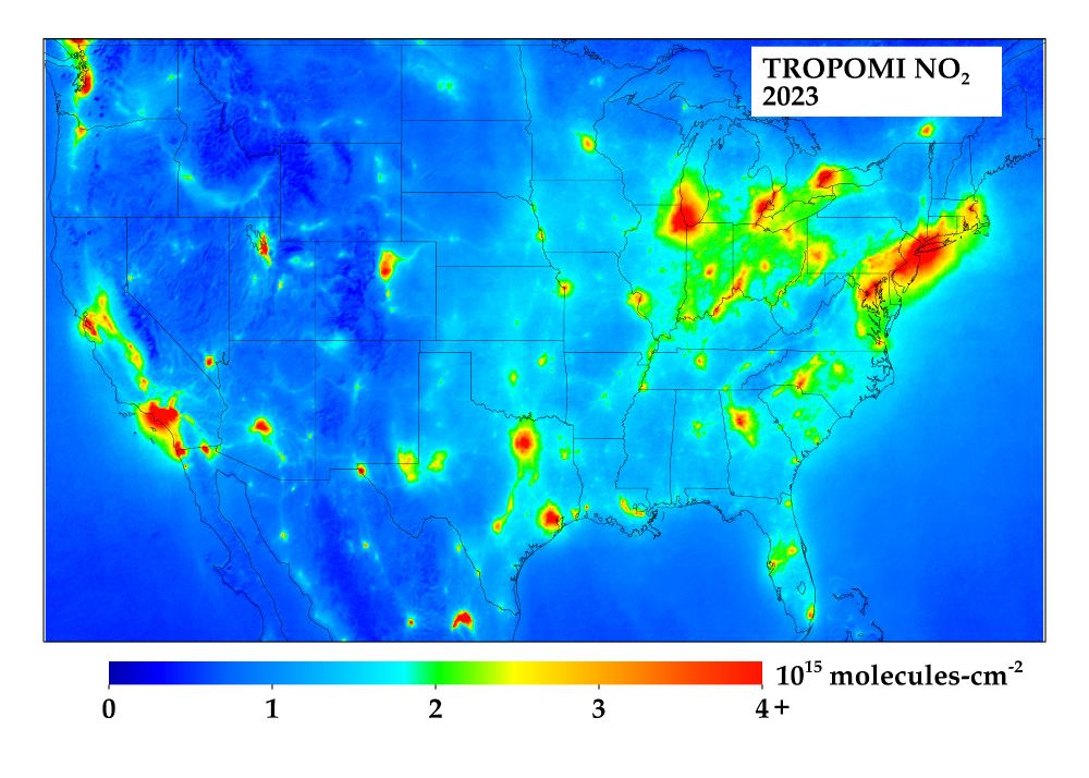
👋 Spinning up my time on here... You'll be getting posts like this one, which shows NO2 pollution as observed by satellite data last year. More posts on air quality, climate, and remote sensing to come!
14.11.2024 21:42 — 👍 24 🔁 4 💬 3 📌 1#DisastersAvoided Newsletter #5
mailchi.mp/8973b1f121fe...
On the #UNDRR Global Assessment Report (GAR) and #NoNaturalDisasters
#DRR #DisastersAreNotNatural (avoid the phrases #NaturalDisaster #NaturalDisasters) #SendaiFramework #Switch2Sendai #SFDRR #DisasterRiskReduction #DisasterRiskManagement
🌊🧪
24.09.2024 21:16 — 👍 3 🔁 1 💬 0 📌 0Imagem registrada pelo satélite da Agência Copernicus mostra que toda a mancha vermelha no mapa é fumaça. O Laboratório de Aplicações de Satélites da UFRJ indicou que o Pantanal brasileiro perdeu dois milhões de hectares por causa das queimadas.
➡ Assista à #GloboNews: glo.bo/39WjXAu
22 years of September fire locations and intensity (shown as Fire Radiative Power) over South America from the #CopernicusAtmosphere GFAS dataset ads-beta.atmosphere.copernicus.eu/datasets/cam... based on NASA Terra+Aqua MODIS 🛰️ active fire obs @copernicusecmwf.bsky.social #wildfires
24.09.2024 12:29 — 👍 40 🔁 16 💬 3 📌 1