ScienceDirect.com | Science, health and medical journals, full text articles and books.
Excited to share the 2nd paper from Olivia Paschall's PhD work, where she demonstrates how adding cross-polarized SAR imagery to the normal co-polarized data can improve inferred deformation rates, applied to Death Valley: kwnsfk27.r.eu-west-1.awstrack.me/L0/https:%2F...
29.01.2026 13:48 — 👍 6 🔁 1 💬 0 📌 0
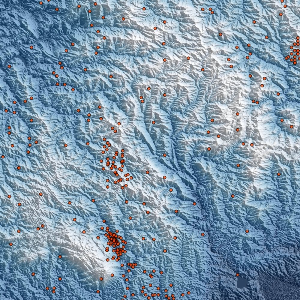
🚨 New map redraws our understanding of how continents deform 🚨
We are excited to share ground-breaking work led by COMET Co-Director @timwrightleeds.bsky.social, published in @science.org. Read more: comet.nerc.ac.uk/new-map-redraws-our-understanding-of-how-continents-deform/
#Tectonics #Research
30.01.2026 11:39 — 👍 11 🔁 7 💬 0 📌 2

COMET InSAR Training Workshop 2025 Resources Now Available!
📹 Full video recordings are live on the COMET YouTube channel: www.youtube.com/watch?v=w0tb...
📊 Presentation slides and practical materials are available on GitHub: comet-licsar.github.io/ciw.html#com...
28.11.2025 00:01 — 👍 6 🔁 6 💬 0 📌 0
YouTube video by COMET Webinars
COMET Webinar: Jin Fang. Satellite Geodetic Constraints on the Kinematics of the Tibetan Plateau
🎧 The latest COMET webinar is now available on YouTube!
If you missed last week’s live session, you can now watch the full recording here:
🔗 www.youtube.com/watch?v=tuhd...
06.11.2025 17:39 — 👍 3 🔁 3 💬 0 📌 0

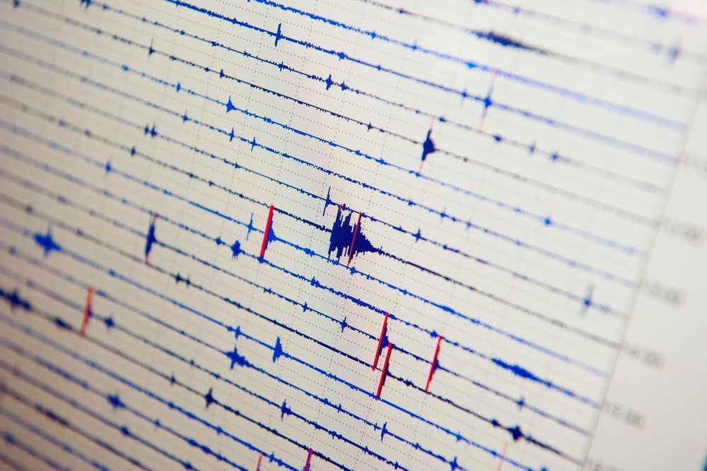
Recovering permanent displacements from seismic records of the June 9, 1994 Bolivia deep earthquake
Ground displacements of the 1994 deep Bolivia earthquake are recovered from six on-scale velocity records of a temporary array located ∼600 km south of the epicenter. I first removed the instrument (...
Permanent deformation of the Earth and its surface happens after *every* earthquake, no matter it's depth or distance.
This has been known to seismologists for decades, because we can see the permanent offset in our seismograms. With large earthquakes, even 100s of km will still cause mm of offset.
27.10.2025 16:59 — 👍 7 🔁 1 💬 2 📌 0
Went out downtown tonight and got leathered with my friend Gordon. (No reason, except Friday.) On the way home, my Uber driver asked me lots of fun questions about earthquakes. And now I'm home and learning that NISAR successfully deployed its reflector?! What a great evening!
16.08.2025 09:01 — 👍 12 🔁 1 💬 0 📌 0
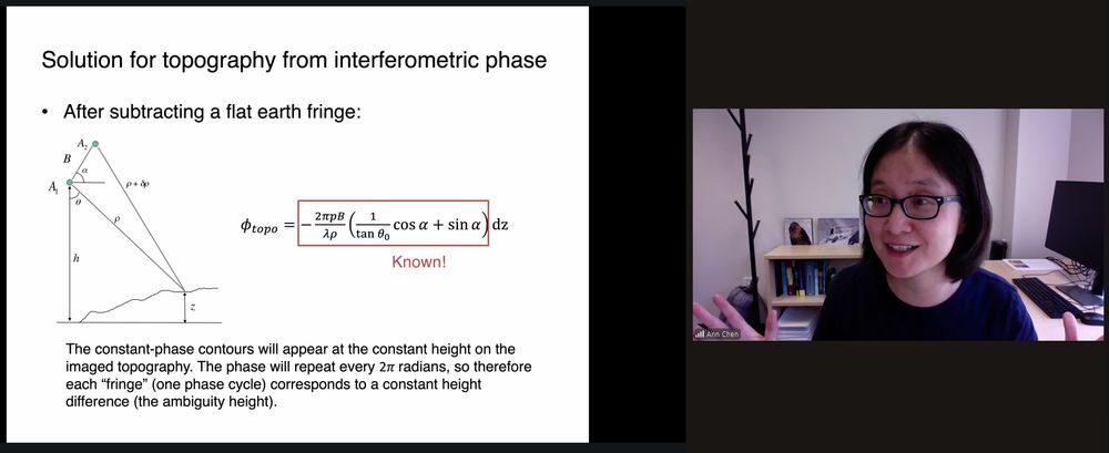
Screengrab from Zoom, on the left a slide about the relationship between surface topography and interferometric phase (the basis for topographic mapping using InSAR), the right a picture of the instructor, Ann Chen.
Here is Ann Chen on a deep dive into InSAR theory, explaining the basis of using InSAR in mapping topography. (Later she will talk about measuring deformation and the causes of decorrelation, all the good stuff!)
18.08.2025 19:44 — 👍 4 🔁 1 💬 1 📌 0

Screengrab of the Zoom from today's class. On the left is the output of a Jupyter notebook showing multiple plots of potential displacement of the volcano for different source locations. On the right is Franz Meyer, my co-instructor, who is leading this session.
It's Day 1 proper of this year's EarthScope #InSAR Processing and Analysis short course (the "ISCE+" course)! Here, Franz Meyer is leading participants through a simple Mogi source modeling exercise using InSAR data from Okmok volcano! Real data and real models on an interactive online platform!
18.08.2025 19:04 — 👍 20 🔁 3 💬 1 📌 0
YouTube video by Institut de physique du globe de Paris
Fault creep: what is it, how do we find it and what does it mean?
Not only did I give a talk at IPGP, but they recorded it and recently uploaded it to YouTube! If you want to hear me talking about fault creep and the various approaches my group uses to study it, this video is for you!
youtu.be/8SGIrUTRpq0?...
11.08.2025 16:57 — 👍 5 🔁 2 💬 0 📌 0
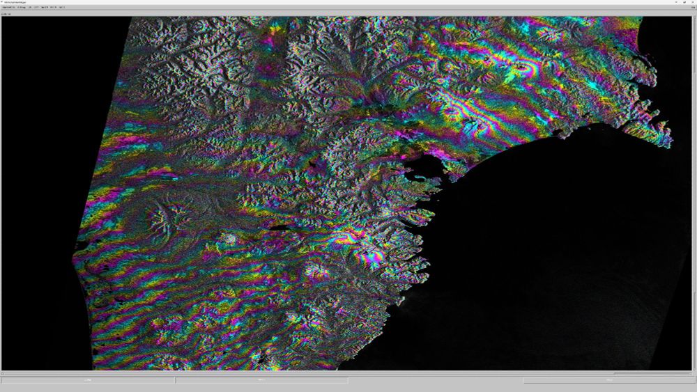
Screen grab of a wrapped interferogram over southern Kamchatka
First Sentinel-1 interferogram from southern Kamchatka! Lots of what I am assuming are tropospheric signals (e.g. over the volcanoes), but I also see long-wavelength fringes that change in azimuth from the NE (~shore-perpendicular) to the SW (~shore-parallel). Optimistic it could be the earthquake!
01.08.2025 09:19 — 👍 25 🔁 6 💬 2 📌 0
YouTube video by NASA Jet Propulsion Laboratory
NISAR Mission Countdown: Preview to Launch
In case you are free in the next few minutes:
www.youtube.com/watch?v=sLjv...
21.07.2025 15:58 — 👍 4 🔁 4 💬 0 📌 0
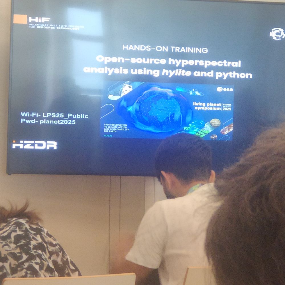
First tutorial of day in ESA living planet 2025 #LPS25 on #hylite for hyperspectral mapping
22.06.2025 13:00 — 👍 5 🔁 0 💬 0 📌 0
Just arrived in Vienna for the ESA Living Planet Symposium after a difficult week shadowed by war. Grateful for the chance to unwind a bit and looking forward to reconnecting with friends and colleagues. 🌍✨ #ESALivingPlanet #Vienna #RemoteSensing
21.06.2025 10:58 — 👍 2 🔁 0 💬 1 📌 0
Seeing Blatten buried again and again, from every angle...
Properly staggering! 😮😱
28.05.2025 18:51 — 👍 421 🔁 186 💬 14 📌 38
Images from @Planet before and after Shahid Rajaee Port blast scar near #BandarAbbas.
30.04.2025 01:13 — 👍 2 🔁 0 💬 0 📌 0
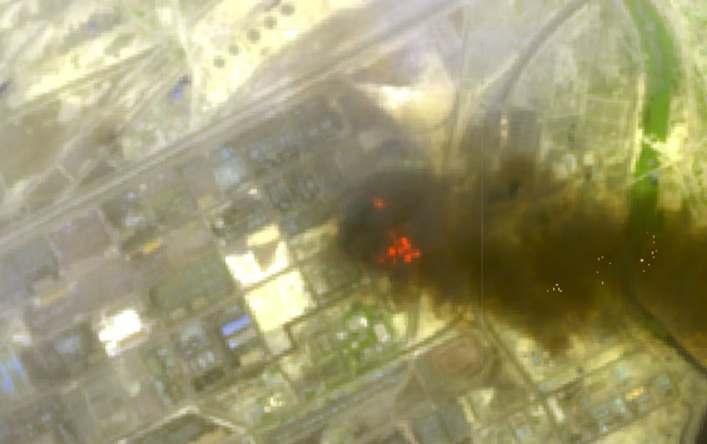
Shahid Rajaee Port
Sentinel-2 SWIR composite (28 Apr ): the Shahid Rajaee Port blast scar near #BandarAbbas. Data:
@CopernicusEU
#RemoteSensing #EO #Iran
30.04.2025 00:57 — 👍 1 🔁 0 💬 0 📌 0
COMET invites you to the next instalment of our COMET webinar series.
Community-driven natural hazard and physical vulnerability assessment – developing a collaborative understanding
23rd April 2025 at 4pm UK time
Dr Annie Winson
BGS, UK
Please register at:
ukri.zoom.us/webinar/regi...
08.04.2025 17:03 — 👍 0 🔁 1 💬 0 📌 0
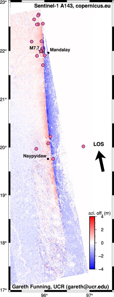
Azimuth offsets of the Myanmar earthquake from Sentinel-1A and Sentinel-1C data. Positive displacements are in the line-of-sight (LOS) direction.
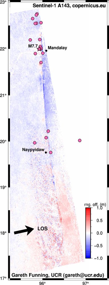
Range offsets of the Myanmar earthquake from Sentinel-1A and Sentinel-1C data. Positive displacements are in the line-of-sight (LOS) direction.
Sentinel-1C(!) acquired new SAR data over Myanmar yesterday. Here are the azimuth and range offsets. Not particularly unexpected (right-lateral slip, 400 km+ long rupture), given earlier InSAR/image offset results, but surprisingly clean, given S1C is not out of its commissioning phase.
04.04.2025 07:49 — 👍 26 🔁 7 💬 1 📌 1
Deniz Ertuncay (dertuncay) | Profil - Evrim Ağacı
İtalya'da bulunan OGS enstitüsünde deprem bilimci olarak çalışmaktayım.
Herkes nasıl da güzel döküldü buraya. Ben daha cool değilken gelmiştim hehe. Üşengeçlikten anlatacak pek bir şeyim yok şu ara ama @evrimagaci.org 'na her ay düzenli olarak ayın depremi yazısı yazıyorum. Oraya bir bakın.
evrimagaci.org/dertuncay/
04.04.2025 19:28 — 👍 3 🔁 1 💬 0 📌 0
PhD position (f_m_x) - Ionospheric Irregularities - Deutsches Helmholtz GeoForschungs-Zentrum
PhD position (f_m_x) - Ionospheric Irregularities - Potsdam, Germany - www.earthworks-jobs.com/jobs/gfz25024 - #jobs #research #PhD #ionosphere #atmosphericscience #geodesy #meteorology #physics #geophysics
28.03.2025 14:27 — 👍 0 🔁 1 💬 0 📌 0
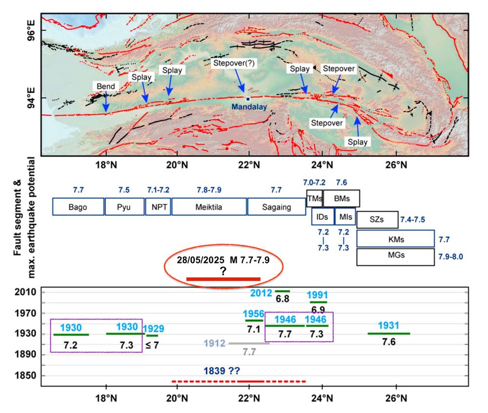
Map showing the segmentation of the Sagaing fault and the hypothetic historical ruptures
Today's #earthquake near Mandalay, Myanmar, had magnitude Mw 7.7 to 7.9.
Prelim. source models point to rupture duration & length of ~120s and at least 200km. It likely filled large part of seismic gap S of Sagaing (previous rupture in 1839) ⚒️ 🧪
Map from doi.org/10.1002/2013... (Wang et al.)
1/n
28.03.2025 16:45 — 👍 123 🔁 54 💬 2 📌 1
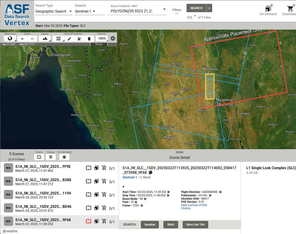
Map from the ASF Vertex SAR data search tool showing most recent acquisitions from March 22, 24 and 27. Given the 12 day repeat for the Sentinel-1 satellites, this would suggest the next pass over the likely area of the Mandalay earthquake would be on April 3.
Looking at Sentinel-1 data availability over the Sagaing fault, and it is going to be several days (April 3rd) before Sentinel-1A flies over the likely rupture zone again. Can anyone at @esaearth.esa.int advise on the possibility of Sentinel-1C acquisitions over the area? #MyanmarEarthquake
28.03.2025 12:30 — 👍 6 🔁 3 💬 1 📌 0
EERI Response to March 28, 2025 M7.7 Mandalay, Myanmar (Burma) Earthquake
EERI, through their Learning from Earthquakes Program, made a web page which collects news outlets and scientific resources about the Myanmar earthquake eeri.org/about-eeri/n...
29.03.2025 07:59 — 👍 23 🔁 11 💬 0 📌 0
We run the "Earth Scientists" feed — pester this account if you want to join
https://bsky.app/profile/did:plc:lpl45lei6abqpvmet5htdbtb/feed/aaakc72k5sgcs
(brought to you by @louis.moresi.info)
🔥 Blog by Dariusz Majgier. AI, fun facts, science & brilliant ideas:
👉 https://patreon.com/go4know
🔥 Get prompts, art styles & tutorials. Learn how to create ChatGPT & Midjourney images!
👉 Join me: https://patreon.com/ai_art_tutorials
Berlin. Painting + illustration. Works in progress
#1dad, unranked filmmaker and undefeated bully-bullier.
I explain how generational wealth has destroyed everything, including those who stand to inherit it.
Doctoral Researcher, 🌏 Computational Geodynamics, ECS IISER Pune,
BSMS Geological Sciences, DES IISER kolkata, 2024
Football is life | A fan of the Selecao & Liverpool FC
Absolutely immersed in the World of One Piece 😁😁
🌐 AmitavaDutta.github.io
M.Sc. Graduate, KNT University
Remote Sensing | Photogrammetry
---→ Environmental Monitoring, Forest Ecology, Wildfire, UAV Photogrammetry, Bundle Adjustment, Canopy Cover
#RemoteSensing #Photogrammetry #UAV #Drone #DeepLearning #GIS
housing + environmental health.
Asst. Professor of urban planning @gsd.harvard.edu
Co-lead healthy places design lab
Formerly OECD, Paris planning, Ad’A
www.magdamaaoui.com
currently working on hospitals x housing, any lead/personal story welcome
aka Boe
big fan of the earth
UW CSE
boezzz.com
Post-doc fellow (FNRS) at Université libre de Bruxelles 🇧🇪, using passive seismic methods towards monitoring volcanic and geothermal environments🌋. Previously 🇭🇲, 🇳🇿, 🇫🇷, originally from Jersey 🇯🇪.
Welcome to the STAC page for Probability and statistics! Probability and Statistics play an important role in all observational sciences, especially in atmospheric science.
https://www.ametsoc.org/stac/committees/committee-on-probability-and-statistics/
Meteorologist. Serving IL, KY, MO, and TN. Scientist. Bachelor of Science from MSU. Entrepreneur. Author. Artist. I ❤️ snow, photography, travel, and adventure. Snow-chaser. Civil rights. #Weather #Meteorology #ClimateChange #Atmosphere #Snow
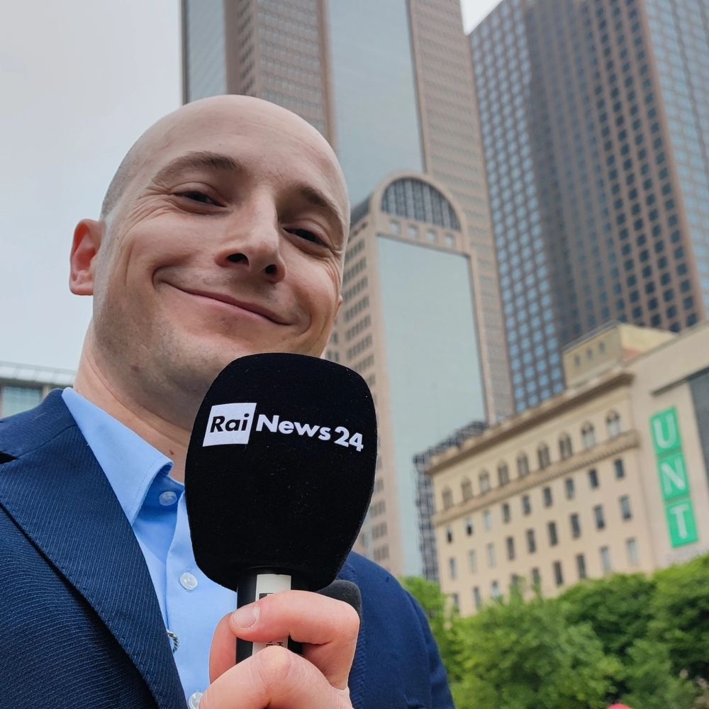
Giornalista scientifico di RaiNews24 e curatore della rubrica Futuro24. Conduttore dei programmi "Oggi è" e "Un giorno per" su Rai Scuola
www.futuro24.rai.it
Seismologist | Green's Postdoctoral Scholar @UCSD | Brown University '23 | Cornell '18 | he/him
ananthariharan1996.github.io
💥 🌊 📈
HAI Fellow @ Stanford focusing on risk & safety 🖇️ 🦜
Open Web & Cloud Computing e-Infrastructure for Earth Sciences
Followed by 2.5k on twitter (X): https://x.com/MLEarthSciences
We tweet/retweet papers related to machine learning/data science/deep learning for Earth and Environmental Sciences. Just email your paper details to mlearthsciences@gmail.com
#research #ML
Satellites. Space.Trees. Prof Edinburgh Uni. Co-founder Earth Blox.