📢If you are interested in InSAR applications in 🌎 Sciences, don't miss this webinar organized by BeGEO, IREA-CNR and Progressive Systems. Register by scanning the QR code or at docs.google.com/forms/d/e/1F... 🌍🛰⚒️ @earth-science.bsky.social #geoscience #AcademicSky
01.04.2025 11:56 — 👍 5 🔁 3 💬 0 📌 0


the Automatic Sentinel-1 #DInSAR coseismic Interferogram (Descending Pass) (Track 121) for the recent seismic in China with a magnitude of Mw 7.1 , @fraxinsar.bsky.social is available www.ics-c.epos-eu.org?share=309dc1...
24.01.2025 11:53 — 👍 1 🔁 1 💬 0 📌 0

#DInSAR
Automatic Sentinel-1 coseismic Interferogram (Descending Pass) (Track 121) for the recent seismic in #China with a magnitude of Mw 7.1, is available on @epos-es.bsky.social geoportal @fraxinsar.bsky.social
13.01.2025 06:34 — 👍 19 🔁 9 💬 0 📌 0

Map of Altadena, Pasadena and adjacent area showing a proxy for damage derived from Copernicus Sentinel-1 radar image acquired at 6 PM local Pacific Time on January 8. Colors show the extensive damage across most of Altadena and the north edge of Pasadena, extending int the north edge of Sierra Madre.
Colleague Sang-Ho Yun at Earth Observatory of Singapore Remote Sensing Lab and his team made a Damage Proxy Map (DPM) from Copernicus Sentinel-1 radar image over the LA, California area acquired at 2 AM UTC 9 Jan. or 6 PM PT January 8, compared with previous […]
[Original post on mastodon.social]
11.01.2025 17:26 — 👍 12 🔁 6 💬 1 📌 0

EOS-RS Damage Proxy Map: California, USA, Wildfires, 9 Jan 2025, v0.9
The Earth Observatory of Singapore - Remote Sensing Lab (EOS-RS) created this preliminary Damage Proxy Map (DPM) depicting areas that are likely damaged in California, USA, due to several wildfires in early Jan 2025. This map was derived from synthetic aperture radar (SAR) images acquired by the Copernicus Sentinel-1 satellite operated by the European Space Agency (ESA) before (11 Sep 2024 to 28 Dec 2024) and during (9 Jan 2025) the event.
The map covers area indicated by a white polygon. Damage is shown by colored pixels of 30m in size, where yellow to red indicates increasingly significant ground surface change before and after the event. Preliminary validation was conducted using news reports and ground-level imagery and videos in selected areas. This map should be used as a guidance to identify damaged areas, and may be less reliable over vegetated or mountainous areas. Scattered pixels may be false positives, and a lack of color may not mean no damage.
The product contains modified Copernicus Sentinel data (2024-2025), processed by ESA and analyzed by the Earth Observatory of Singapore - Remote Sensing Lab (EOS-RS).
More map details and files at: https://eos-rs-products.earthobservatory.sg/EOS-RS_202501_USA_California_Wildfires/
Credits: Earth Observatory of Singapore - Remote Sensing Lab (EOS-RS), Contains modified Copernicus Sentinel data (2024-2025)
The full map is attached below, with the zooms on the Eaton Fire, Palisades Fire, and Lidia Fire, and covers area indicated by the white polygon. Damage is shown by colored pixels of 30m in size, where yellow to red indicates increasingly significant ground […]
[Original post on mastodon.social]
11.01.2025 17:38 — 👍 3 🔁 2 💬 0 📌 0


the Automatic #Sentinel-1 #DInSAR coseismic Interferograms for the recent vulcano techtonic crisis in #Awash, #Ethiopia, 20241217-20250110, 20241229-20250110 (Descending Pass, Track_79), all available in @epos-es.bsky.social @fraxinsar.bsky.social
10.01.2025 11:08 — 👍 3 🔁 1 💬 0 📌 0


#DInSAR Automatic Sentinel-1 coseismic Interferogram and LOS Displacement map (Ascending Pass) for the recent seismic in #China with a magnitude of Mw 7.1, is available on
@epos-es.bsky.social geoportal @fraxinsar.bsky.social
08.01.2025 06:19 — 👍 3 🔁 1 💬 1 📌 0

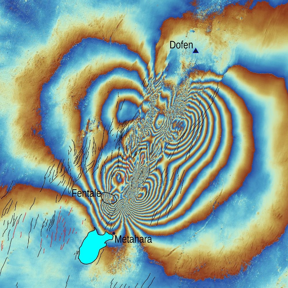
New magma intrusion in Fentale seen by Sentinel interferogram made by UNIPI group in support to Addis Abeba University
30.12.2024 08:19 — 👍 30 🔁 10 💬 3 📌 4

Mapping Earth and Planetary Surfaces through Statistical Learning - Call for Papers
Mapping of Earth and Planetary surfaces through Statistical Learning – Call for Papers
There is still time to submit original contributes to this (OA) special issue on Applied Computing and Geosciences.
Submission deadline: 31 March 2025
www.sciencedirect.com/special-issu...
05.12.2024 11:37 — 👍 0 🔁 0 💬 0 📌 0
Nature Communications is an open access journal publishing high-quality research in all areas of the biological, physical, chemical, clinical, social, and Earth sciences.
www.nature.com/ncomms/
Geophysicist at lab in Pasadena, California. Statements and opinions posted by me are my own and not those of my employer. he/him. Header image is […]
🌉 bridged from https://mastodon.social/@EricFielding on the fediverse by https://fed.brid.gy/
linking, casting and bursting Earth science data for disaster risk reduction and climate change studies @terradue
just over here crashing my bike. Oh and random earthquake stuff.
Crap forgot to add my ridiculous opinions are sadly my own, unless you got in my head somehow. Nice work, you!
(Planetary geology) practitioner - https://blob.aprossi.eu - Owner at earthgraph.bsky.social
Hazard scientist at the British Geological Survey. I post about natural hazards, earth observation, InSAR, climate change & disaster risk. Also my cat and books I'm currently reading.
El nodo español de EPOS, la única infraestructura europea de investigación mutidisciplinar en Ciencia de la Tierra sólida.
https://epos-es.org/ciencia-abierta-para-entender-la-tierra-solida-que-es-epos/
Professor at Virginia Tech, Lead, Land Subsidence Analytics at United Nations University, US Rep. to UNESCO LASII
Web: EOIvt.com
Professor of Geology
SESE, ASU http://public.asu.edu/~arrows/
This bot pulls data from the USGS's real-time earthquake feed and posts a summary of any event in the lower 48 states having a preliminary magnitude 3.5+
made with 🫶🏼 by @DataDrivenMD.social
**NOT AFFILIATED WITH USGS**
The #CopernicusClimate Change Service (#C3S) & #CopernicusAtmosphere Monitoring Service (CAMS), implemented by @ecmwf.int on behalf of the @ec.europa.eu.
earthquake geologist
https://orcid.org/0000-0002-1213-0828
https://seismofaults.eu
https://tsumaps-neam.eu
https://sismolab3d.ingv.it
Italian, Australian, earth observation scientist focused on coastal and shelf waters. Bio-optics, operational ocean Colour, hyperspectral data.
🌊🛰👨💻🇮🇹🇦🇺
Physicist • TT Assistant Prof, @UHouston / @DLR_en visiting scientist • I use Synthetic Aperture RADAR to monitor Deformation and Topography • my own statements
Open access to high-resolution, Earth science-oriented topography data, and related tools & resources. US National Science Foundation supported. #lidar https://www.opentopography.org
Official AGU: supporting 500k+ Earth & space science advocates.
🌏 🚀 🔬
Save the Date for #AGU26 in San Francisco, CA, 7-11 December, 2026.