Great thanks Ed!
30.05.2025 11:45 — 👍 1 🔁 0 💬 0 📌 0
Might be useful, TV weather community?
istheukhotrightnow.com
@liamdutton.bsky.social, @metmatt-taylor.bsky.social, @chrisblanchett.bsky.social, @paultheweatherman.bsky.social, @barrabest.bsky.social, @chrispage90.bsky.social, @torilacey.bsky.social, @kerriegosney.bsky.social, @rossitv.bsky.social
30.05.2025 10:45 — 👍 13 🔁 3 💬 1 📌 0
A beautiful start!
07.04.2025 10:23 — 👍 1 🔁 0 💬 1 📌 0
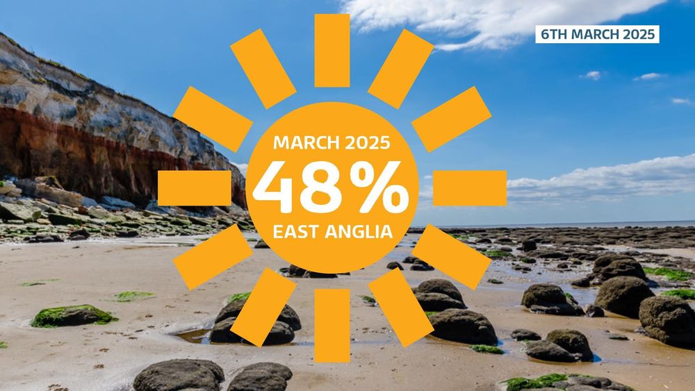
East Anglia has already seen nearly half the normal amount of sunshine for March in just the first six days!
07.03.2025 13:36 — 👍 41 🔁 2 💬 1 📌 0
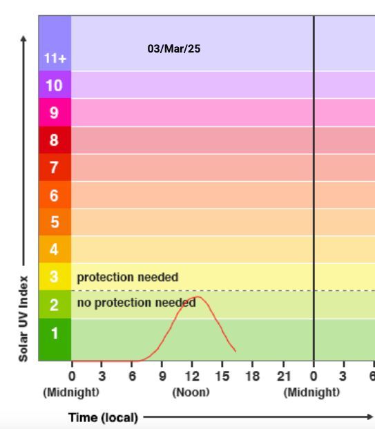
The sun's strength is ramping up in the UK! ☀️ We're now approaching the upper level of 2 on the UV index, which is considered low. Level 3 is classed as moderate and it's often advised we should consider wearing sun screen
Here's today's UV reading from the University of Reading
03.03.2025 17:27 — 👍 22 🔁 7 💬 4 📌 0
ARCTIC HISTORIC WARMTH
Temperatures up to +5C in the Svalbard with above freezing minimums (again +2.4 Ny Alesund !).
Records also in Russia
HISTORIC first above freezing temperature (+0.1C Hayes Island) in February in the Franz Joseph Land.
Records coming also in Alaska/Canada
03.02.2025 15:24 — 👍 55 🔁 23 💬 0 📌 3
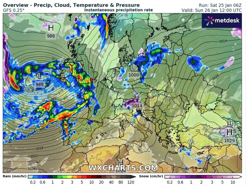
Graphic shows a deep area of low pressure pushing heavy amounts of rainfall to towards western Europe. Named Storm Herminia by the Spanish Met Service it is expected to bring heavy rain fall to the southwest of the UK followed by strong gusts of wind up to 70mph across southern and western coasts of Britain
Currently our attention is drawn to the Atlantic where the next storm (named Herminia by Spanish) will bring up to 80mm of rain in parts of the south & west of UK through Sunday and into Monday, followed by further strong gusts of wind. Although not as powerful as Storm Éowyn
25.01.2025 16:54 — 👍 3 🔁 1 💬 1 📌 0
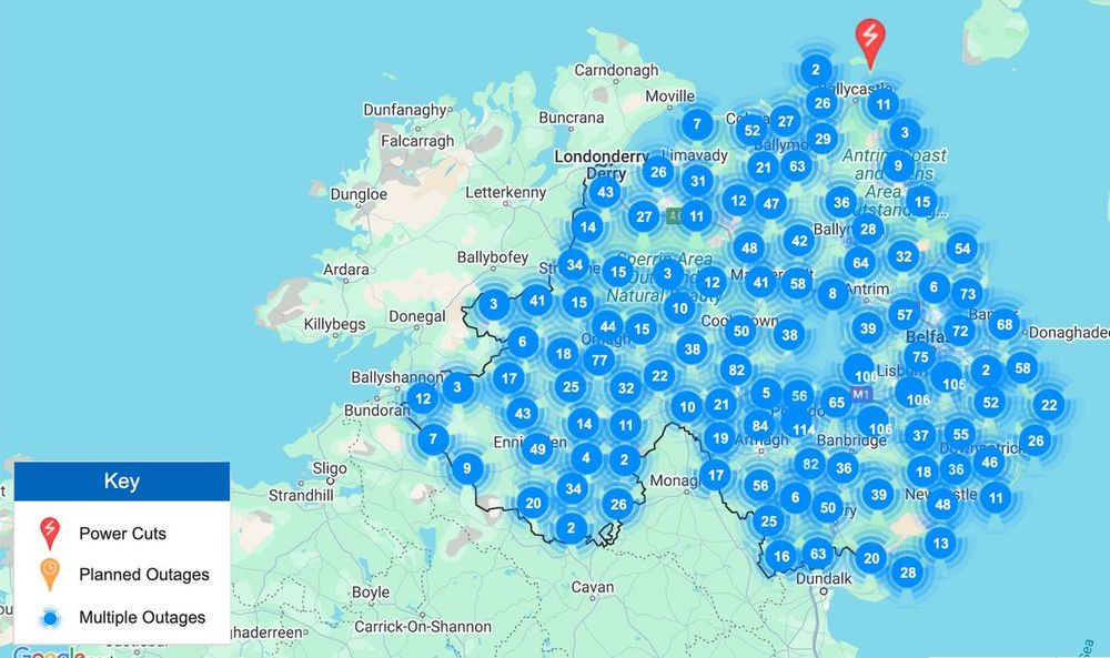
Graphic showing the number of power outages across Northern Ireland
One man sadly died as a tree fell on his car.
For the UK, 77,000 properties are currently still without power with the majority being in Northern Ireland which could take 10 days to get power back online.
25.01.2025 16:54 — 👍 1 🔁 0 💬 1 📌 0
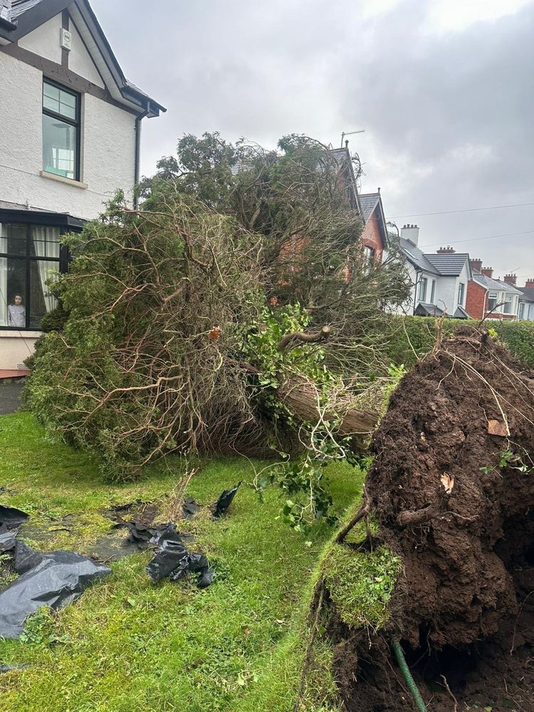
Shows a treed felled outside a person's house in Northern Ireland
The storm produced record wind gusts for the Republic of Ireland reaching 114mph (Mace Head), meanwhile 101mph (Drumalbin, Lanarkshire) were recored in the UK. The Met Office believe it was the worst storm for some parts of the UK for 20-30 years.
25.01.2025 16:54 — 👍 0 🔁 0 💬 1 📌 0
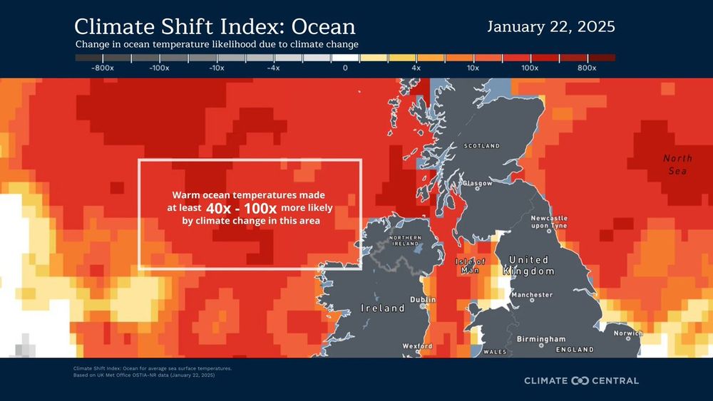
Graphic show how the warmer waters around the west of Ireland are deep shades of red. This shows temperatures of the oceans were 40-100x more likely due to climate change
🌀#StormÉowyn a thread
A worrying read but early evidence suggest warmer waters in the Atlantic, caused by man-made climate change, helped to intensify #StormÉowyn according to Climate Central
25.01.2025 16:54 — 👍 13 🔁 1 💬 1 📌 0
Over half don’t you mean? 🤣
17.01.2025 08:29 — 👍 0 🔁 0 💬 1 📌 0
Rise in carbon dioxide off track for limiting global warming to 1.5°C
The increase of atmospheric carbon dioxide (CO₂) is now incompatible with IPCC pathways which remain below 1.5°C, a Met Office study finds.
🌍 CO2 Forecast 2025: The Mauna Loa observatory predicts a rise in CO2 levels to 426.6 ± 0.6 ppm in 2025. This continues the alarming trend of increasing atmospheric CO2 👉 bit.ly/4ghvdcl
#GetClimateReady #CO2Forecast
17.01.2025 07:05 — 👍 107 🔁 52 💬 2 📌 7
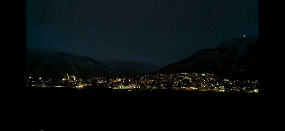
After 49 days of darkness, on Wednesday this week the people of Tromsø, Norway saw the sun for the first time since the 26th November. A total of 54 minutes of daylight for them, as the polar night came to an end for another year!
17.01.2025 06:23 — 👍 64 🔁 14 💬 6 📌 2
Something you don’t see every day. People in Upware, Cambridgeshire were ice skating on Sunday after five consecutive days of temperatures being below freezing! 🥶
This is a controlled environment where the ice is 4 inches thick - awesome!
📹 Elizabeth Swan
#iceskating #iceskatingfun
14.01.2025 07:50 — 👍 87 🔁 12 💬 3 📌 0
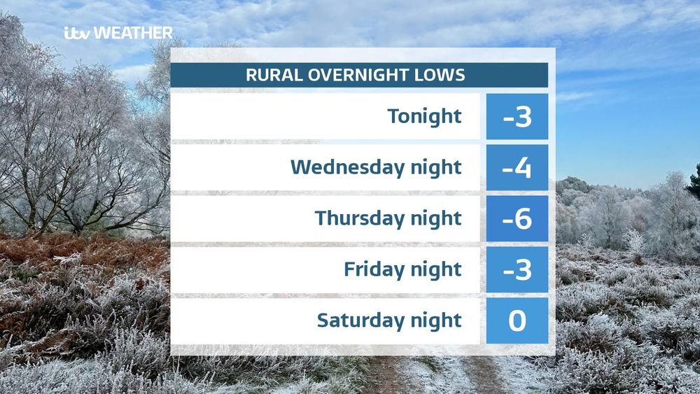
🥶 We've some cold chilly nights to come leading to a severe frost in places. These are the expected rural overnight lows for the coming nights for the ITV Anglia region.
Thursday night is likely to be the coldest night of the winter so far
07.01.2025 18:12 — 👍 7 🔁 3 💬 1 📌 0
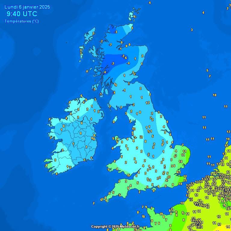
What a contrast in temperatures to start today.
That colder air will spread eastwards through today as the rain and cloud clears up. Keep that woolly pulley to hand this week 🥶
06.01.2025 09:49 — 👍 13 🔁 3 💬 2 📌 0
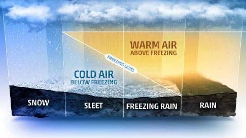
Freezing rain - it's one of the most dangerous winter hazards. We rarely get it in the UK but when it happens it can produce some treacherous conditions.
Find out more in my latest blog post here www.itv.com/news/anglia/...
03.01.2025 14:34 — 👍 33 🔁 9 💬 4 📌 2

It’s happening!! #TheTraitors
01.01.2025 20:03 — 👍 4 🔁 0 💬 0 📌 0
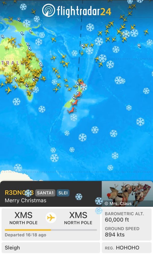
He’s started!
Crusing at 60,000ft - that’ll be rather cold 😳🎅🏼❄️
#TrackSanta from Flight Radar
24.12.2024 11:23 — 👍 18 🔁 1 💬 2 📌 0
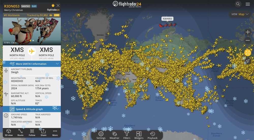
Santa flying eastward over far-northern Russia on the Flightradar24 map.
We’ve received word that all presents are loaded and the reindeer are ready. Santa is heading east for the first gifts of Christmas. Follow Santa at www.flightradar24.com/R3DN053/3875...
24.12.2024 05:54 — 👍 166 🔁 42 💬 6 📌 7
Happy Christmas Eve EVE!
23.12.2024 16:29 — 👍 19 🔁 0 💬 0 📌 0
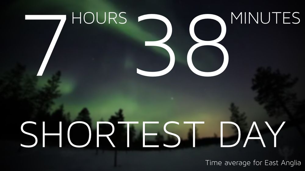
We’ve done it! Welcome to the #shortestday! From this point forward day length gradually increases and the nights get shorter
21.12.2024 08:34 — 👍 59 🔁 9 💬 2 📌 2
Fancy a festive swim this Christmas? 🎅🏊♂️
Sea temperatures are around 8 Celsius on the East Coast. This is about a degree warmer than what we would expect at this time of year
18.12.2024 18:13 — 👍 1 🔁 0 💬 0 📌 0
🎄CHRISTMAS DAY FORECAST 🎄
Mild. Dry. Light winds for most. Breezy in the north and across Scotland. Could be rather cloudy.
Doesn’t look to be a white Christmas this year.
18.12.2024 15:49 — 👍 5 🔁 2 💬 0 📌 0
Are you dreaming of a #whiteChristmas? The latest weather models are painting a clearer picture of what we could expect to see. I explain more here
www.itv.com/news/anglia/...
16.12.2024 16:24 — 👍 1 🔁 0 💬 0 📌 0
I was going to say Happisburgh
16.12.2024 14:22 — 👍 1 🔁 0 💬 1 📌 0
Hmmm I’m not sure! Where!?
16.12.2024 14:08 — 👍 1 🔁 0 💬 1 📌 0
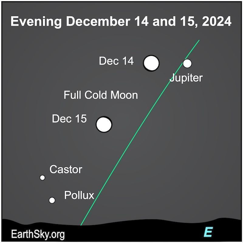
Sky chart with 2 positions of the round moon near the slanted green ecliptic line, and dots for Jupiter and stars.
Full moon fell at 9:02 UTC on Sunday morning. The moon will be past full in your sky tonight but it is still near Jupiter and moving closer to Castor and Pollux. Read more at: https://earthsky.org/astronomy-essentials/visible-planets-tonight-mars-jupiter-venus-saturn-mercury/
15.12.2024 14:47 — 👍 10 🔁 4 💬 0 📌 0
Don’t worry. Brighter days are ahead :)
12.12.2024 13:52 — 👍 1 🔁 0 💬 1 📌 0
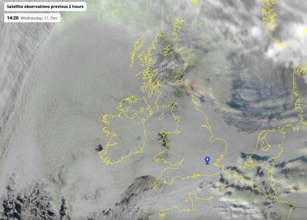
Another day of very little sunshine, here's the earlier satellite imagery from space
@netweather.bsky.social
11.12.2024 16:10 — 👍 24 🔁 5 💬 2 📌 1
Weather for ITV north ☀️🌈⛈️💞
Former Met Office Meteorologist and current Weather Forecaster for ITV
creativity / photography / art directy / travely
climate scientist
posts 100% my own
🇨🇦 is my home
distinguished professor & chair, Texas Tech
chief scientist, The Nature Conservancy
board member, Smithsonian NMNH
alum, UToronto and UIUC
author, Saving Us
TV Meteorologist. Ex Met Office. Blue skies are OK but I quite like clouds too.
West Riding of Yorkshire.
Prof of Water Science and Health at Uni of Leeds. Geography - Hydrology - Malaria - Climate - Geomorphology. Dabble in icey stuff too. Oh and running... lots of running.
"A tireless chronicler and commentator on all things climate" -NYTimes.
Climate research lead @stripe, writer @CarbonBrief, scientist @BerkeleyEarth, IPCC/NCA5 author.
Substack: https://theclimatebrink.substack.com/
Twitter: @hausfath
Climate Scientist at Met Office and University of Exeter. Author of Hot Air: The Inside Story of the Battle Against Climate Change Denial
👨🏽💼Channel 4 Weather Presenter
☀️Meteorologist
🎵Pianist & Musician
📚Author
🧑🏽💻 www.liamdutton.com
Assistant Professor - School of Earth Sciences @ Illinois
Executive Producer ITV NEWS - Tonight / On Assignment / Docs / Longform
Reporter. Royals. Journalism. News. Broadcasting. Photography. Travel.
Anchor: Loose Women and ITV News
Columnist: The ipaper
Writer: “No Place Like Home”
3rd-party TweetDeck for Bluesky from 🇧🇷! Featuring columns, multi-account, scheduling and inline translations! Developed by @gildaswise.com
App: https://deck.blue
Contact: hello@deck.blue
Donation: https://patreon.com/deckblue | https://ko-fi.com/deck_blue
National Meteorologist l Spectrum News
Reporter for the ITV News Regions.
@nicksmithITV on X and Facebook.
Youtube: https://www.youtube.com/@NickSmithITV
Website: https://www.itv.com/news/meet-the-team/nick-smith