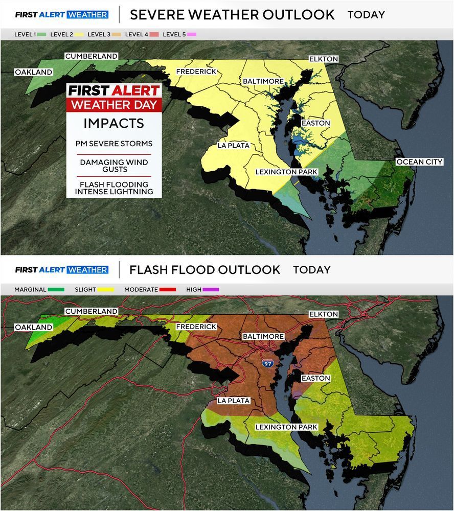
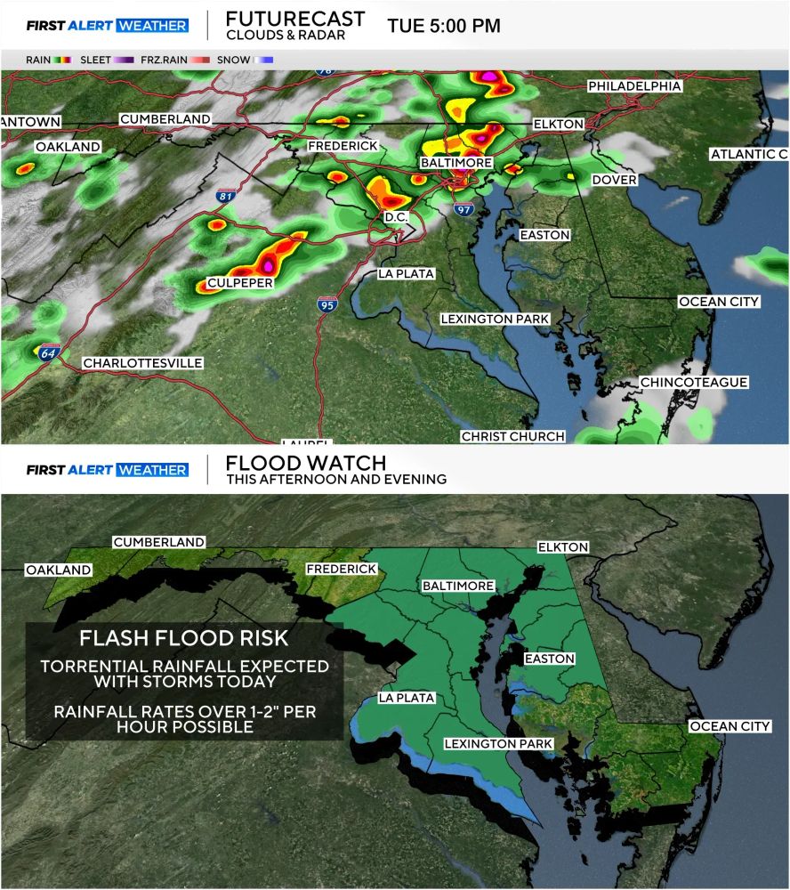
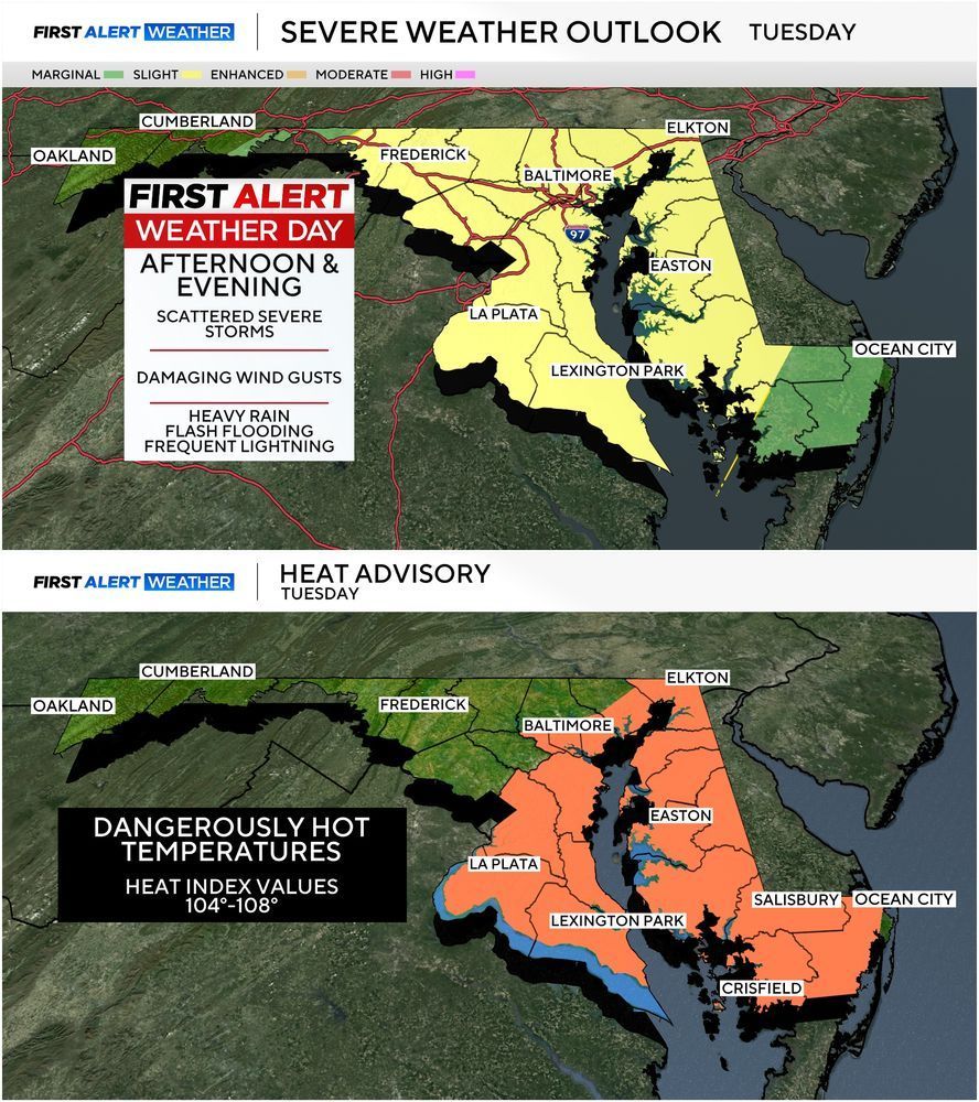
Severe thunderstorms with damaging wind potential and flash flooding are expected later today across the Baltimore Area. Rainfall rates could exceed 2" per hour at times with totals over 5"+ in localized areas that see repeated rounds of storms. #mdwx
31.07.2025 15:00 — 👍 0 🔁 0 💬 0 📌 0
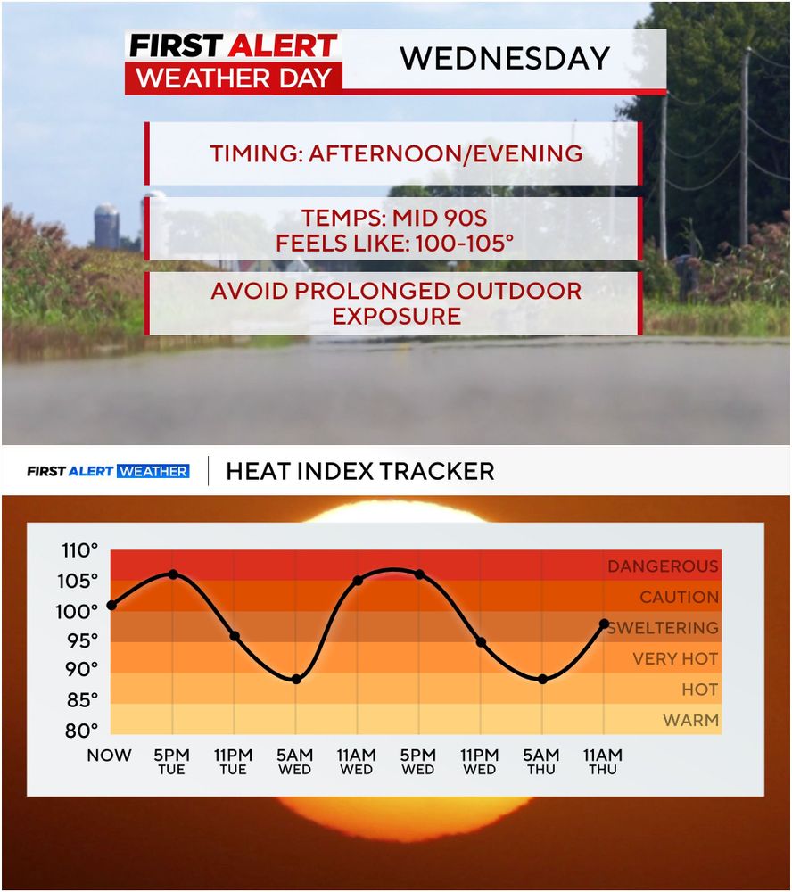
Same old song and dance...different day. ALERT DAY continues WEDNESDAY for high heat/humidity. By Friday & the weekend all of it will be a distant memory as heat relief arrives. #mdwx
29.07.2025 15:11 — 👍 1 🔁 0 💬 0 📌 0

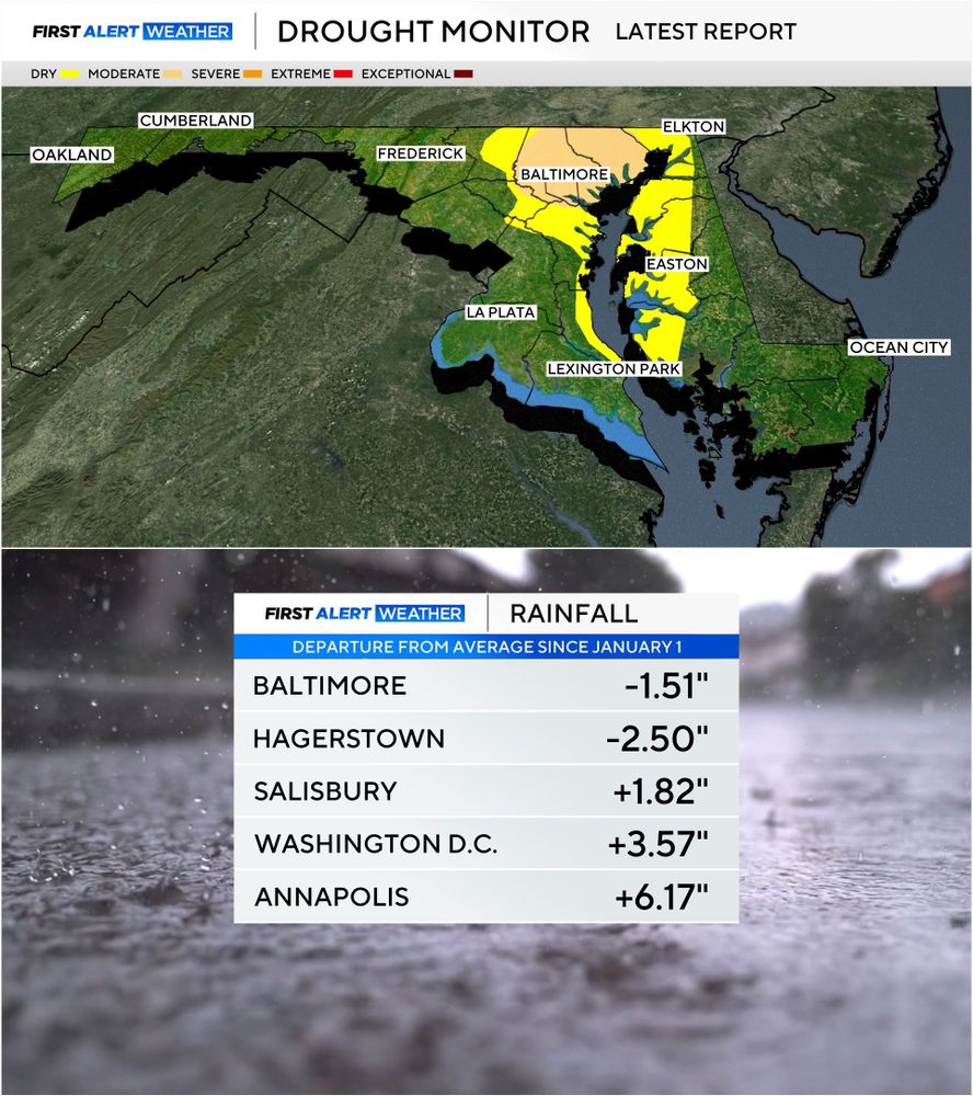
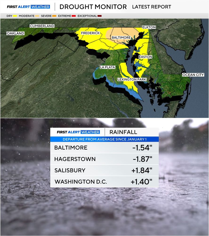
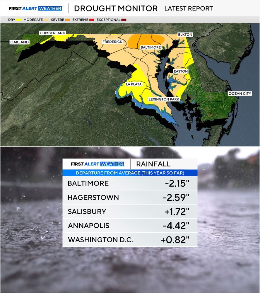
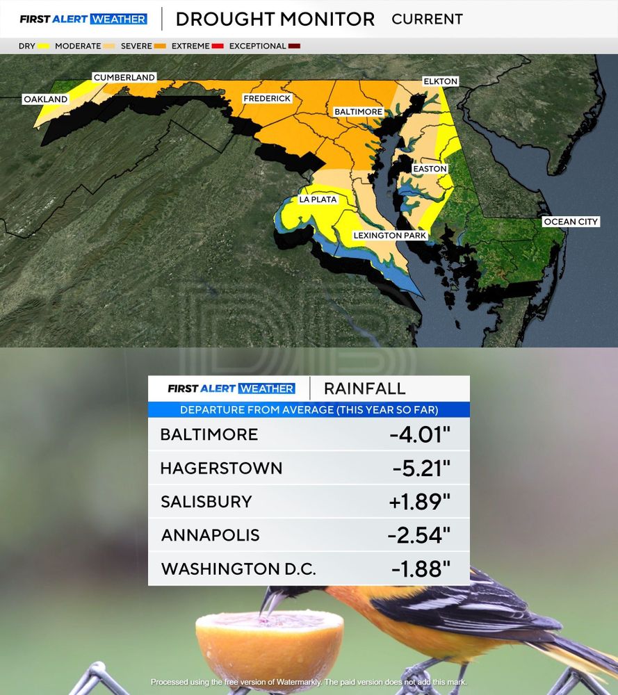
DROUGHT UPDATE: Much better this week. And after this week's rain the yellow should be gone by next week's update. Baltimore now reporting a surplus in rainfall for the year. #mdwx
17.07.2025 17:02 — 👍 0 🔁 0 💬 0 📌 0
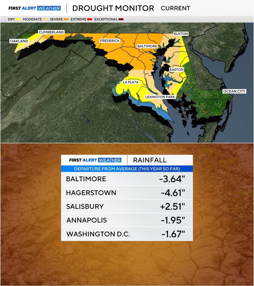
DROUGHT UPDATE: The recent rains have helped some but it hasn't been evenly distributed. Some saw a lot more than others. Still running a small deficit in some areas. The rain we saw yesterday and Tuesday should help even more. #mdwx
10.07.2025 17:19 — 👍 0 🔁 0 💬 0 📌 0
STORMY AFTERNOON/EVENING AHEAD: Severe storms are expected later today with initial development along I-81 by early afternoon with storms marching eastward toward I-95 by the evening rush hour. Storms today will be capable of wind damage, torrential rainfall that could cause flash flooding. #mdwx
08.07.2025 15:42 — 👍 0 🔁 0 💬 0 📌 0
ALERT DAY FOR TUESDAY 7/8: Severe storms are expected across the region Tuesday afternoon/evening as a cold front approaches the area. Heavy rain, gusty winds & frequent lightning are likely. Before storms arrive heat index values will top 100°. #mdwx
07.07.2025 19:33 — 👍 0 🔁 0 💬 0 📌 0
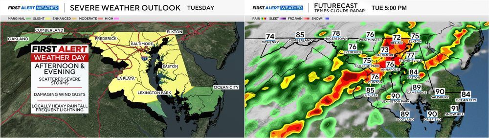
TUESDAY SEVERE STORMS: There is a chance for isolated severe storms this afternoon but the greater threat arrives Tuesday. Timing will be mid to late afternoon through the early evening. Damaging wind gusts the main threat. #mdwx
30.06.2025 16:47 — 👍 0 🔁 0 💬 0 📌 0
DROUGHT UPDATE: Significant improvement in the drought situation this week from last week's rain. Still a deficit for the year. #mdwx
05.06.2025 14:19 — 👍 0 🔁 0 💬 0 📌 0
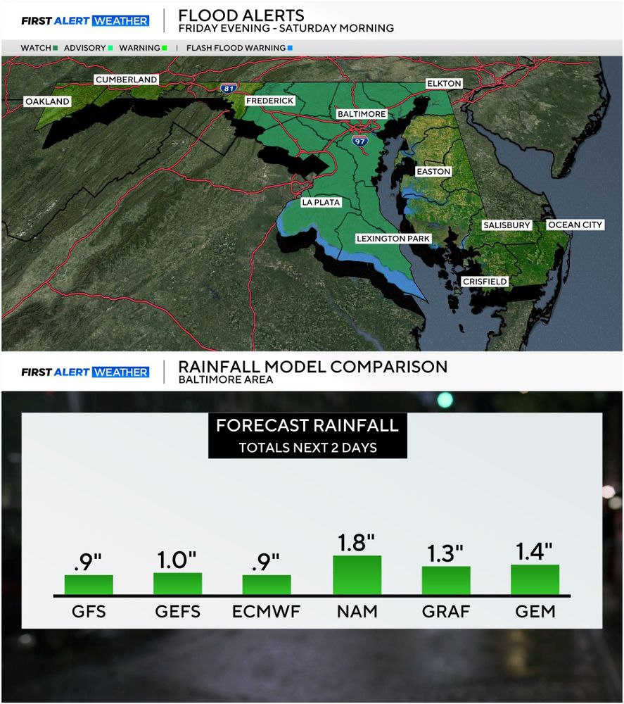
*FLOOD WATCH* has been issued for much of central & southern Maryland from Fri. evening - early Sat. morning. Additional rainfall of 1-3" (see Forecast Model Comparison) will be possible leading to areas of minor flooding Fri. night and early Sat. #mdwx
30.05.2025 02:30 — 👍 1 🔁 0 💬 0 📌 0
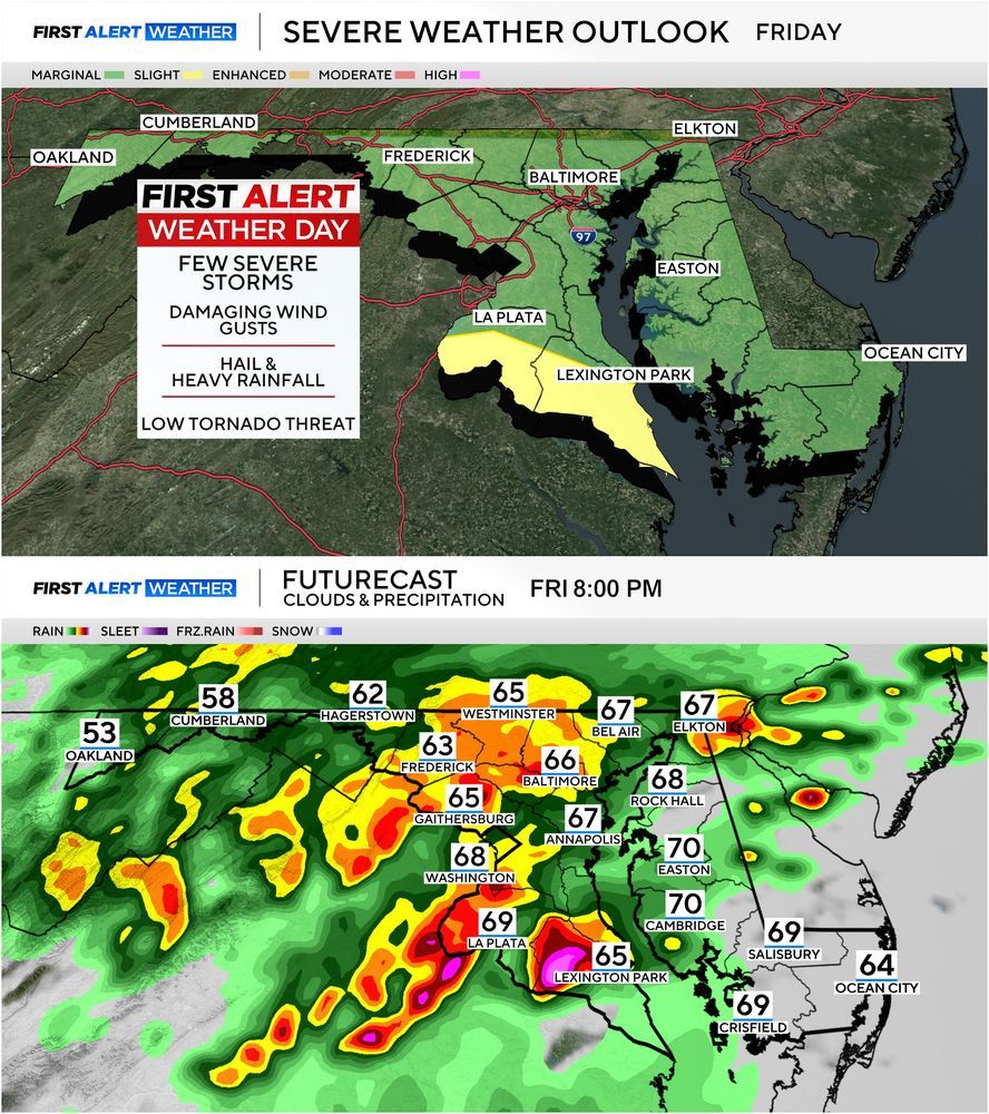
Heads up for your Friday evening plans: Severe storms are still expected Friday afternoon - Friday night across Maryland. Damaging wind gusts, hail, heavy rainfall are possible with a low-end tornado threat in southern MD. Plan accordingly! #mdwx
29.05.2025 19:24 — 👍 0 🔁 0 💬 0 📌 0
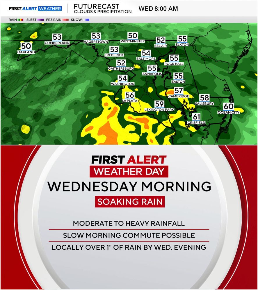
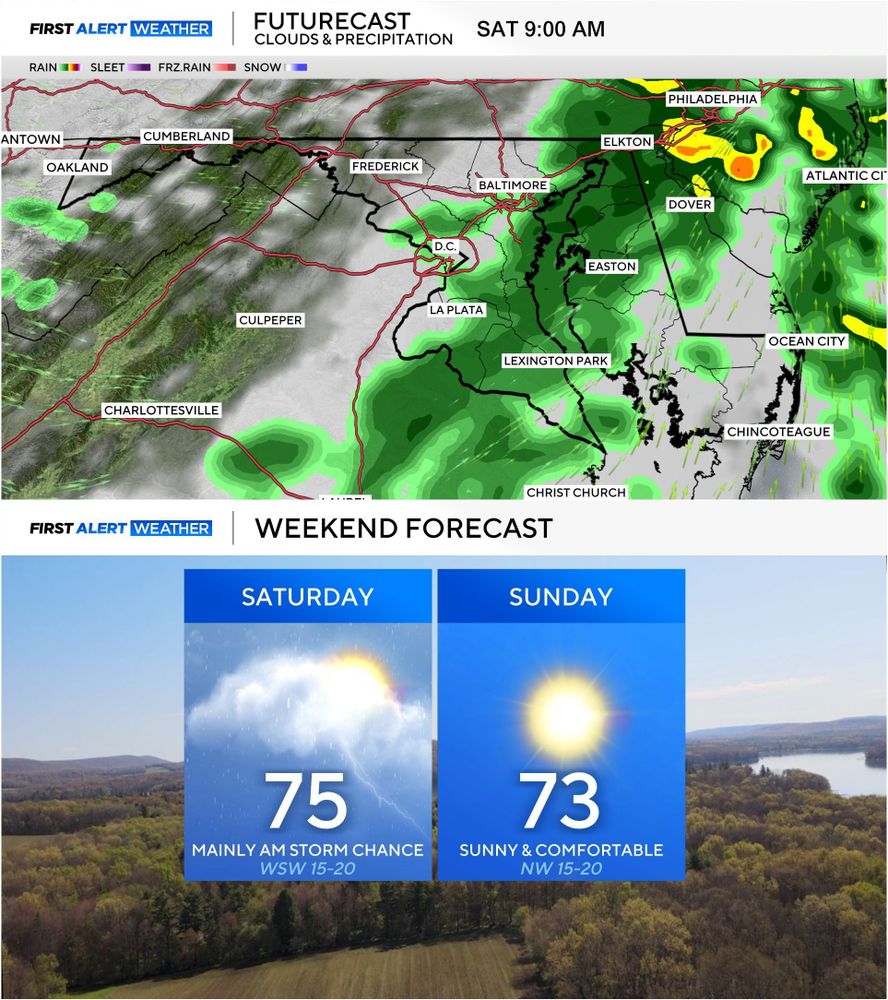
ALERT DAY WEDNESDAY: The morning commute will be a slow as widespread moderate rain will move into the region later tonight. Allow some extra time to get to your destination. The rain will become lighter by afternoon. #mdwx
27.05.2025 23:39 — 👍 0 🔁 0 💬 0 📌 0
DROUGHT UPDATE: Situation is improving thanks to last week's rain but the deficit remains. More rain opportunities arrive next week. #mdwx
22.05.2025 13:59 — 👍 0 🔁 0 💬 0 📌 0
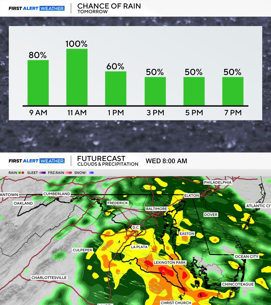
WET WEDNESDAY AHEAD: High rain chances are expected Wednesday morning across the area and this could impact your AM commute. No severe weather is expected but we've issued an ALERT DAY to account for some minor inconveniences the rain may cause. #mdwx
20.05.2025 16:55 — 👍 0 🔁 0 💬 0 📌 0
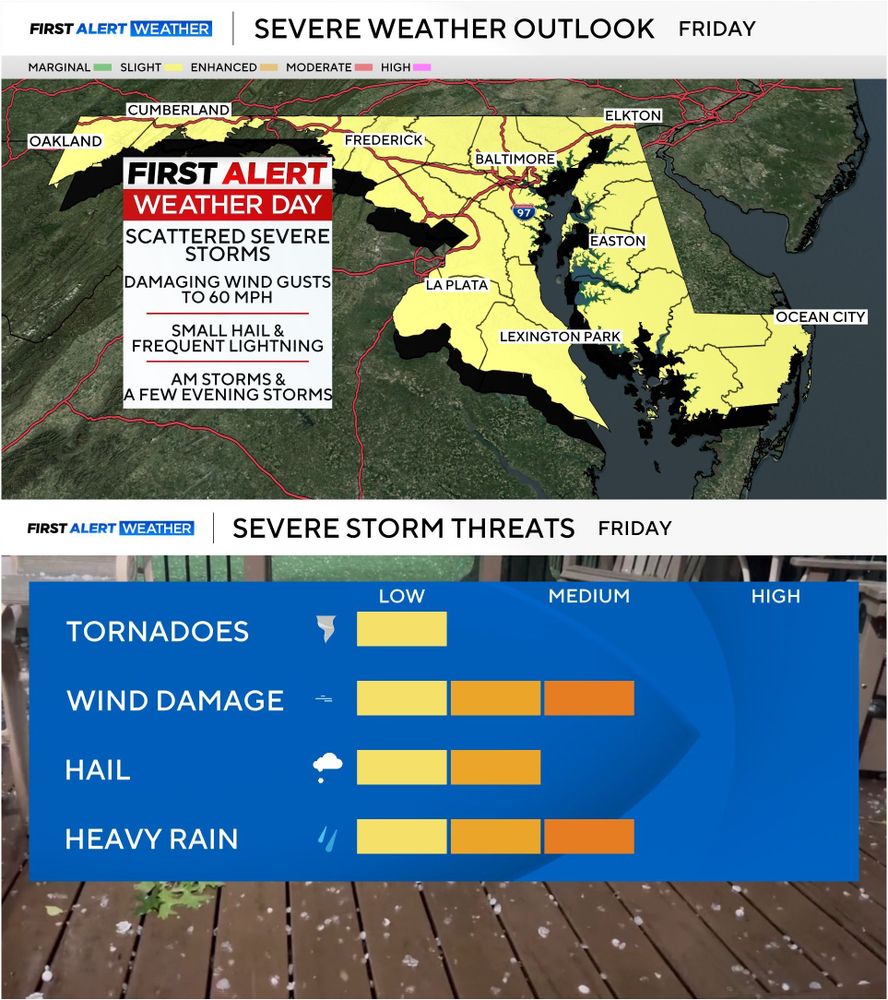
SEVERE RISK UPGRADE: All of Maryland is now in a Leve 2 SLIGHT RISK for severe storms on Friday. Same threats of high winds and hail. Multiple rounds of storms possible but each will be conditional based on how the weather pattern evolves through the day. #mdwx
15.05.2025 19:34 — 👍 0 🔁 0 💬 0 📌 0
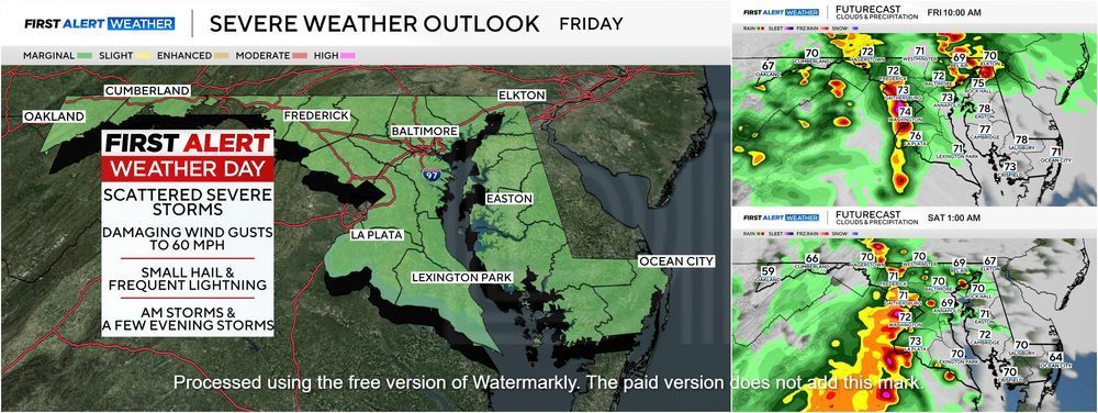
FIRST ALERT WEATHER DAY FRIDAY: We are monitoring the potential for strong/severe storms for Friday. Friday morning and again Friday night. We are also monitoring Saturday for isolated strong storms. Wind & hail will be the main threats. We'll keep you updated. #mdwx
15.05.2025 17:08 — 👍 0 🔁 0 💬 0 📌 0
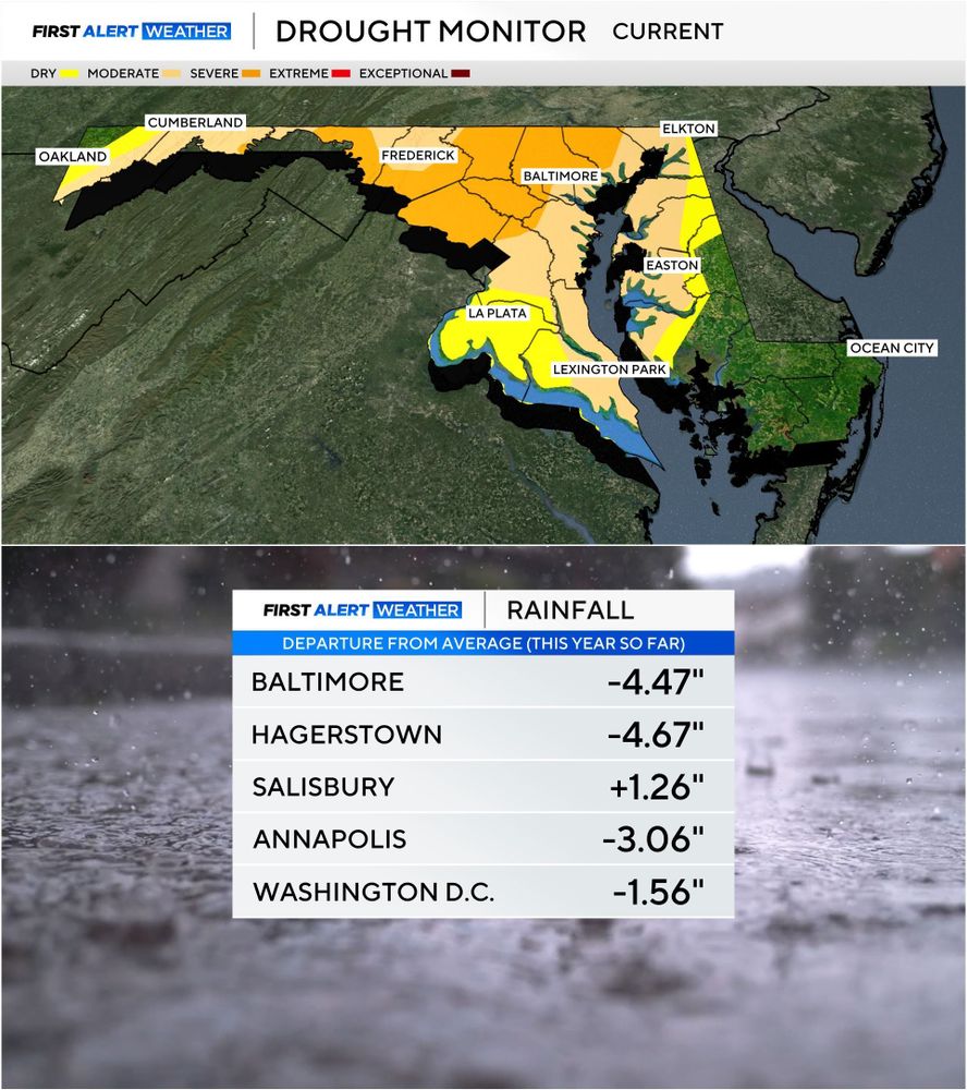
DROUGHT UPDATE: Last week's rain helped but we need more. Still running a 4" rainfall deficit in Baltimore. #mdwx
08.05.2025 22:13 — 👍 0 🔁 0 💬 0 📌 0
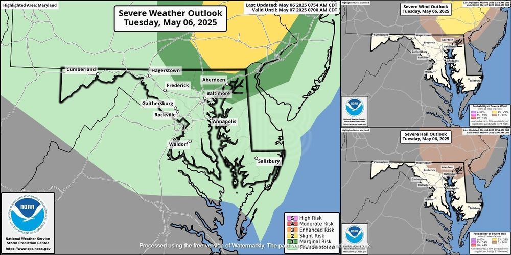
TODAY'S SEVERE THREAT: Storm development this afternoon will not be as widespread as Monday with scattered storms producing isolated damaging wind gusts and some hail mainly across north central and northeast MD. #mdwx
06.05.2025 14:00 — 👍 0 🔁 0 💬 0 📌 0
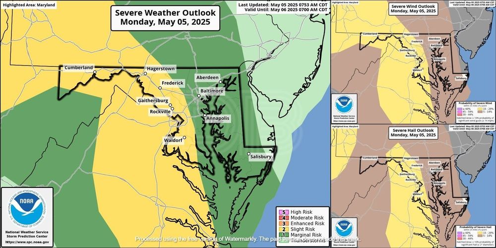
Today's severe weather threat has been upgraded and now includes a level 2 *SLIGHT RISK* for portions of central and western Maryland. Hail and damaging winds will be the primary risks through sunset. #mdwx
05.05.2025 14:55 — 👍 1 🔁 0 💬 0 📌 0
UPDATED DROUGHT MONITOR: Rainfall deficit over 4" now for the near in Baltimore. Relief is on the way as early as this weekend! #mdwx
01.05.2025 17:08 — 👍 0 🔁 0 💬 0 📌 0
UPDATED DROUGHT MONITOR: Severe drought continues across much of Maryland. Rainfall deficit 3-4" below average since January. Better chance for soaking rain comes later next week. #mdwx
24.04.2025 17:22 — 👍 1 🔁 0 💬 0 📌 0
WEEKEND OUTLOOK: Morning rain chances Saturday then smooth-sailing into Sunday. We need the rain but amounts don't look impressive. Sunday will be a fantastic day to spend outside. #mdwx
24.04.2025 17:07 — 👍 0 🔁 0 💬 0 📌 0
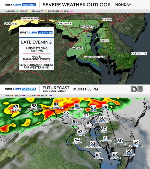
STORMS POSSIBLE LATE MONDAY: There is a low-end threat for severe storms across mainly western MD on Monday evening. Wind & hail will be the main threats although a non-zero risk for tornadoes exists for far western MD. Timing will be after dark through early Tues. AM. #mdx
13.04.2025 13:47 — 👍 1 🔁 0 💬 0 📌 0
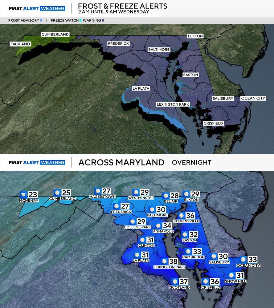
VERY CHILLY OVERNIGHT: Temps will dip into the upper 20s and lower 30s under clear skies and lighter winds. Protect cold-sensitive plants overnight as a *FREEZE WARNING* has been issued for most of Maryland. Wind chills could dip as low as the low 20s by Wednesday morning. #mdwx
08.04.2025 14:26 — 👍 0 🔁 0 💬 0 📌 0
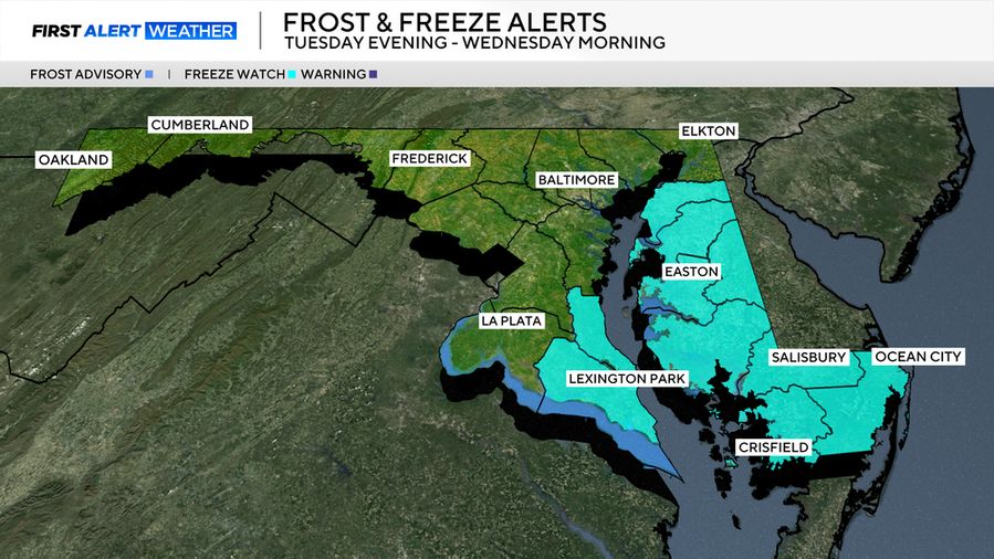
*FREEZE WATCH* in effect for parts of southern Maryland & the Eastern Shore Tuesday night through Wednesday morning. Overnight temps will dip into the 20s and lower 30s and could lead to damage to unprotected plants. #mdwx
08.04.2025 01:13 — 👍 0 🔁 0 💬 0 📌 0
Evening Storm Potential 🚨 Once again, the WJZ team is watching the potential for a few evening storms. Storms may bubble up to our west & quickly move through. One or two may become strong. Check in with the forecast, especially if you have plans.
@cbsnewsbaltimore.bsky.social
05.04.2025 20:51 — 👍 0 🔁 1 💬 0 📌 0
Strong storms are rolling through Baltimore County with torrential rain and frequent lightning. Stormy evening is ahead. @derekbeasleywx.bsky.social is tracking rough weather live on WJZ
📱 www.cbsnews.com/baltimore/li...
31.03.2025 22:34 — 👍 0 🔁 1 💬 0 📌 0
Rain, storms blast through Maryland late this afternoon & evening. Few storms will be severe.
@derekbeasleywx.bsky.social and the team will be tracking storms through the area on WJZ.
•• With an earlier first pitch, better shot at getting the entire game in before rough weather.
31.03.2025 15:09 — 👍 0 🔁 1 💬 0 📌 0
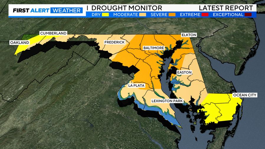
Latest #drought monitor keeps much of #Maryland in moderate to severe drought conditions. We will need a lot more rain that what we got last night to chew into the deficit. #mdwx
21.03.2025 15:17 — 👍 1 🔁 0 💬 0 📌 0
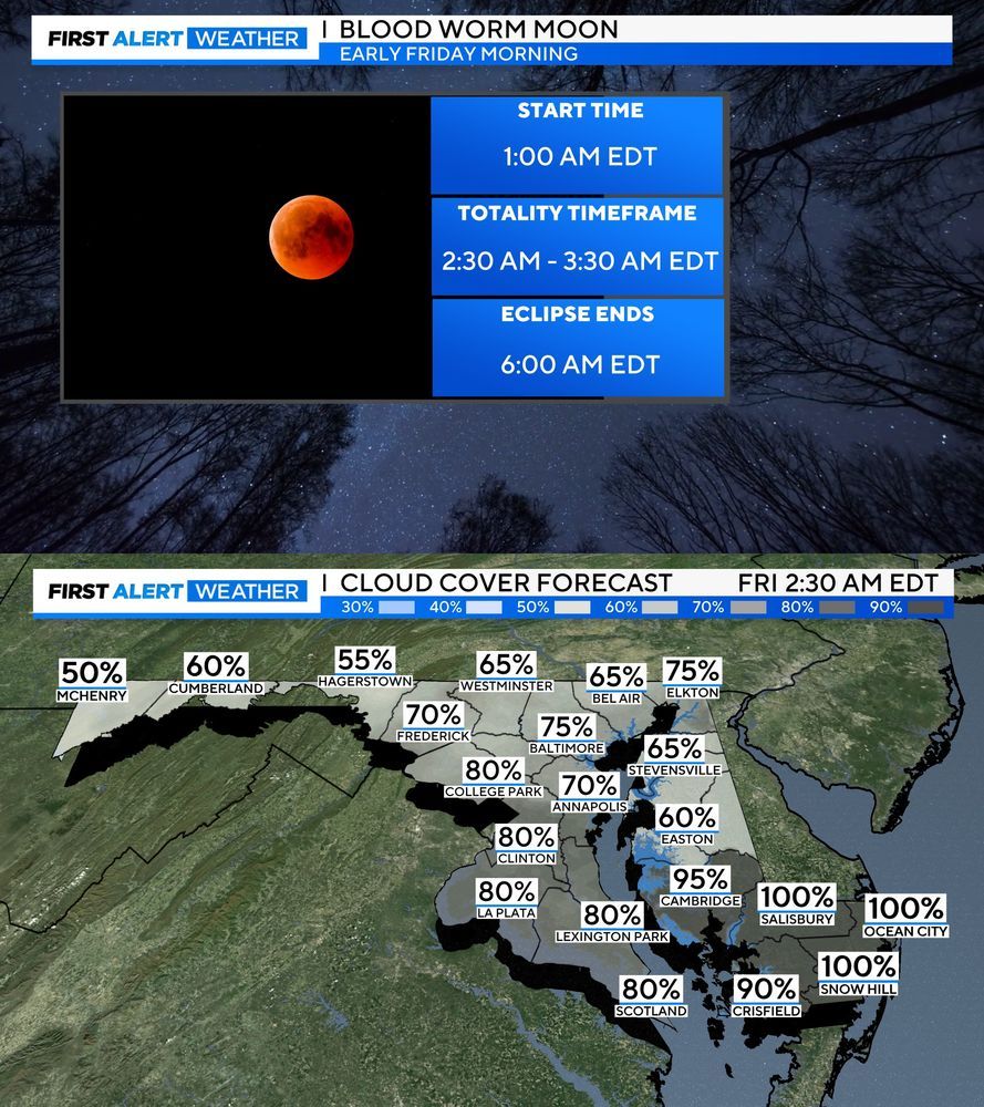
LUNAR #ECLIPSE VIEWING FRIDAY MORNING: Chances aren't looking great for viewing Friday morning as low clouds will likely become a problem. If for some reason conditions turn out better than expected here is the timeframe in which it will be visible here in Maryland. #mdwx
12.03.2025 22:53 — 👍 1 🔁 0 💬 0 📌 0
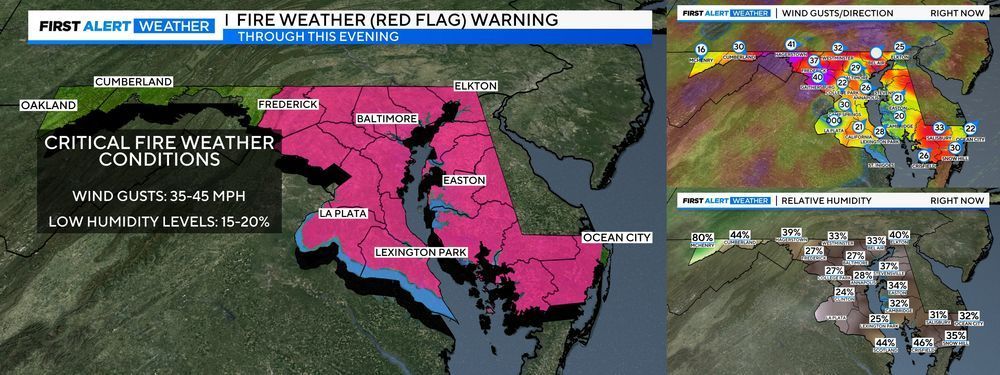
CRITICAL FIRE DANGER THIS AFTERNOON: A large portion of Maryland has been upgraded to a RED FLAG WARNING through this evening. The combination of strong gusty winds (35-45 mph) and low humidity (10-20%) is creating a high fire danger. #mdwx
01.03.2025 17:27 — 👍 1 🔁 0 💬 0 📌 0
Meteorologist at WJZ | CBS Baltimore
Lover of weather, food and the beach. 😎
He/Him. Meteorologist, former Emergency Manager.
🏳️🌈💜🖤🩶🤍
"The horrors persist, but so do I."
“Radically OK” — Meteorologist / Software Eng. w/ CIRA/NOAA GSL; Formerly NSSL, NCAR; SvrWx & Photog Enthusiast. Boomer!
WJZ meteorologist | content creator (weather and astronomy updates) | STEM advocate
Penn State meteorology grad
📍Baltimore, Maryland
Meteorologist at KEYC-TV
MSState Alumna 🐾
Chief Meteorologist NBC 15 in Mobile, AL. NWA Seal of Approval. Opinions are mine.
Certified Meteorologist at FOX4 in Kansas City (CBM #851) 🌩️ • #KCwx #MOwx #KSwx • 📨 Email: Jacob.Lanier@fox4kc.com
Atmospheric scientist-Remote Sensing & Numerical Modeling. GEOINT/Space & Aviation
@NCState | Meteorologist/Stormwater for @RaleighGov and Freelance for @WRAL| Founder of North Carolina’s Weather Authority with over 650k followers on FB|
https://t.co/rmPgbwdgpH
Found of Find Your Tornado Shelter and map maker. Also works on consulting and products for local and national media outlets within the realm. Graduated with my Ph.D. from Mississippi State in 2023. God has got me this far...what's next?
Chief Meteorologist at KCCI in Des Moines, IA
Frmr. Television meteorologist. Current logistics specialist. Alum of University of Alabama and Mississippi State. Swiftie 💕🐍Lover of weather and my pups.Roll Tide!
Create and share social media content anywhere, consistently.
Built with 💙 by a global, remote team.
⬇️ Learn more about Buffer & Bluesky
https://buffer.com/bluesky
Chief Meteorologist at WFMY in Greensboro, NC. Weather, sports, food, nature photos, cats and random thoughts.
Penn Stater. College football should be played all year. Central NY born, but North Carolina is home now.
AMS CBM #552
Founder of Triad weather HQ on Facebook with 14K+ followers|weather in the Triad of NC| Storm spotter|
Local media guy in West Palm Beach. Thoughts expressed here are not necessarily my own. Past performance is not indicative of future results. May contain forward-looking statements. No responsibility or liability for errors or omissions.
🌊 Meteorologist | 🤷🏼♀️ Obnoxiously overuse y'all | 💁🏼♀️ Specialize in sarcasm
Meteorologist for Crown Weather. Avid amateur astronomer. Happily married for 15 yrs to @icecat516. Dog dad to 6 rescues. Bruins, Red Sox & Celtics fan. I live in Central Mass but have lived in Maine & New Hampshire.
Was On X/Twitter as @crownweather
official Bluesky account (check username👆)
Bugs, feature requests, feedback: support@bsky.app