Northern lights visible in Huntsville, AL!
12.11.2025 02:42 — 👍 1 🔁 0 💬 0 📌 0
A spectacular "cold wake" is evident along former-hurricane Erin's track. This is a normal feature caused by strong winds upwelling/mixing cooler water from below. Erin was not only very intense but also very large, which also helps with the upwelling. The water temperatures will gradually recover.
26.08.2025 12:32 — 👍 103 🔁 26 💬 2 📌 1
Welp, I just taught my first class ever! I'm excited to teach undergraduate and graduate students about natural hazards and their societal impacts.Thank goodness, it was syllabus day because I finished the class 40 minutes early. Here's to a good semester.
21.08.2025 23:23 — 👍 5 🔁 0 💬 0 📌 0
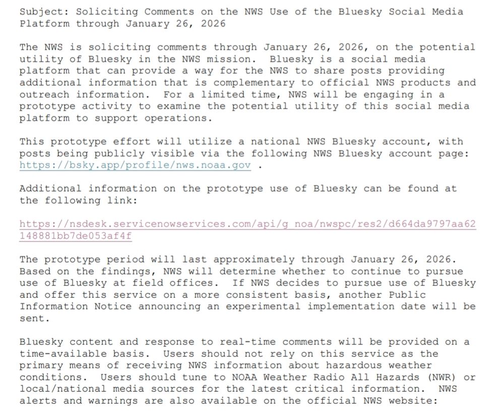
The NWS is soliciting comments through January 26, 2026, on the potential
utility of Bluesky in the NWS mission. Bluesky is a social media
platform that can provide a way for the NWS to share posts providing
additional information that is complementary to official NWS products and
outreach information. For a limited time, NWS will be engaging in a
prototype activity to examine the potential utility of this social media
platform to support operations.
This prototype effort will utilize a national NWS Bluesky account, with
posts being publicly visible via the following NWS Bluesky account page:
https://bsky.app/profile/nws.noaa.gov .
Additional information on the prototype use of Bluesky can be found at
the following link:
https://nsdesk.servicenowservices.com/api/g_noa/nwspc/res2/d664da9797aa62
148881bb7de053af4f
The prototype period will last approximately through January 26, 2026.
Based on the findings, NWS will determine whether to continue to pursue
use of Bluesky at field offices. If NWS decides to pursue use of Bluesky
and offer this service on a more consistent basis, another Public
Information Notice announcing an experimental implementation date will be
sent.
Bluesky content and response to real-time comments will be provided on a
time-available basis. Users should not rely on this service as the
primary means of receiving NWS information about hazardous weather
conditions. Users should tune to NOAA Weather Radio All Hazards (NWR) or
local/national media sources for the latest critical information. NWS
alerts and warnings are also available on the official NWS website:
The NWS is doing a test run of using Bluesky.
www.weather.gov/media/notifi...
23.07.2025 12:46 — 👍 1568 🔁 382 💬 43 📌 59
I'm pretty sure I just saw a plane get struck my lighting taking off from Huntsville International Airport.
20.05.2025 23:02 — 👍 0 🔁 0 💬 0 📌 0
Three fights in the first 9 seconds of the game! #USAvsCAN
16.02.2025 01:29 — 👍 3 🔁 0 💬 1 📌 0
Three inches of snow so far in Huntsville, AL #alwx
10.01.2025 15:36 — 👍 0 🔁 0 💬 1 📌 0

Map of thundersnow from 5 January 2025. A total of 2496 GLM flashes were classified as thundersnow.
While many people were watching the snow accumulating, the Geostationary Lightning Mapper was busy observing #thundesnow. This is just a friendly reminder that #thundersnow is much more common than you think. 🧪
06.01.2025 21:56 — 👍 6 🔁 2 💬 0 📌 0

Geographic map of thundersnow from 05 December 2024.
Now that's a lot of #thundersnow from 5 December 2024. I've had family/friends in Michigan reach out to me and say they thought they saw/heard it 🧪
06.12.2024 17:21 — 👍 6 🔁 0 💬 0 📌 0
This is grate 🤣
06.12.2024 01:54 — 👍 977 🔁 175 💬 26 📌 31
So if the Department of Education is scrapped with the next admin, does that mean student loans are also scrapped? I'm asking for 40+ million friends...
04.12.2024 00:54 — 👍 0 🔁 0 💬 0 📌 0
Yes, feel free to save the 1st graphic as I personally produced it. I just ask that I'm credited for it.
30.11.2024 19:28 — 👍 1 🔁 0 💬 0 📌 0
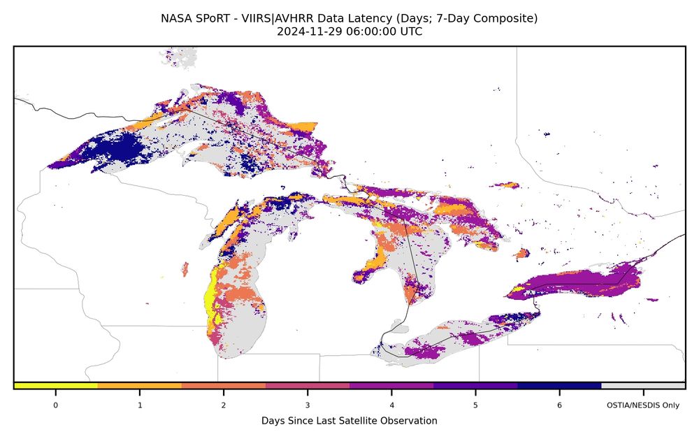
Geographic map of the Great Lakes showing days since the last satellite observation regarding sea surface temperature.
The NASA SPoRT sea surface temperature plot looks spotty owing to the multi-day blending methodology. This product blends 7 days worth of satellite data to reduce gaps caused my persistent cloud cover which is extremely common in the Great Lakes during the winter.
30.11.2024 19:07 — 👍 0 🔁 0 💬 0 📌 0

Geographic map of thundersnow that occurred on 29 November 2024
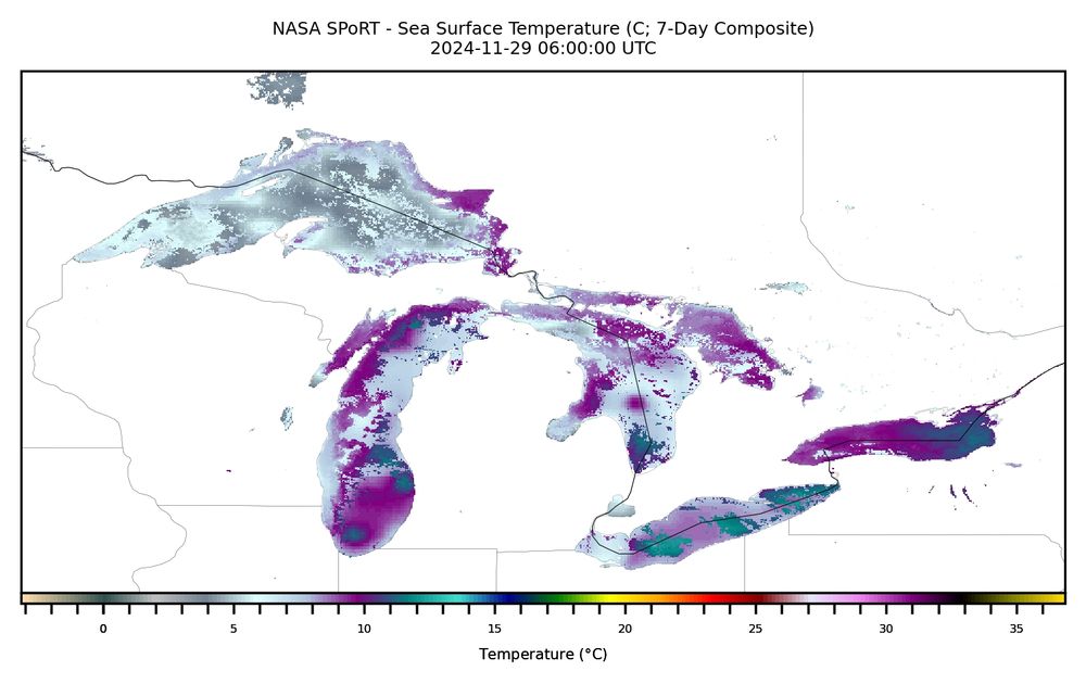
Geographic map of sea surface temperatures of the Great Lakes on 29 November 2024.
The Great Lakes and Northeast regions have been experiencing a plethora of #thundersnow flashes and lake-effect snow. This is caused by cold arctic air moving over the relatively warm waters of the Great Lakes, as shown by the NASA SPoRT SST product. 🧪
30.11.2024 19:03 — 👍 1 🔁 0 💬 2 📌 0
Thanks for the validation data point! @wxkaitlynj.bsky.social
22.11.2024 12:37 — 👍 7 🔁 1 💬 0 📌 0

Geographic map of thundersnow detected om 20 November 2024.
No thundersnow was observed yesterday. However, all the snowfall images on here have brought me a lot of joy!
21.11.2024 22:37 — 👍 0 🔁 0 💬 0 📌 0
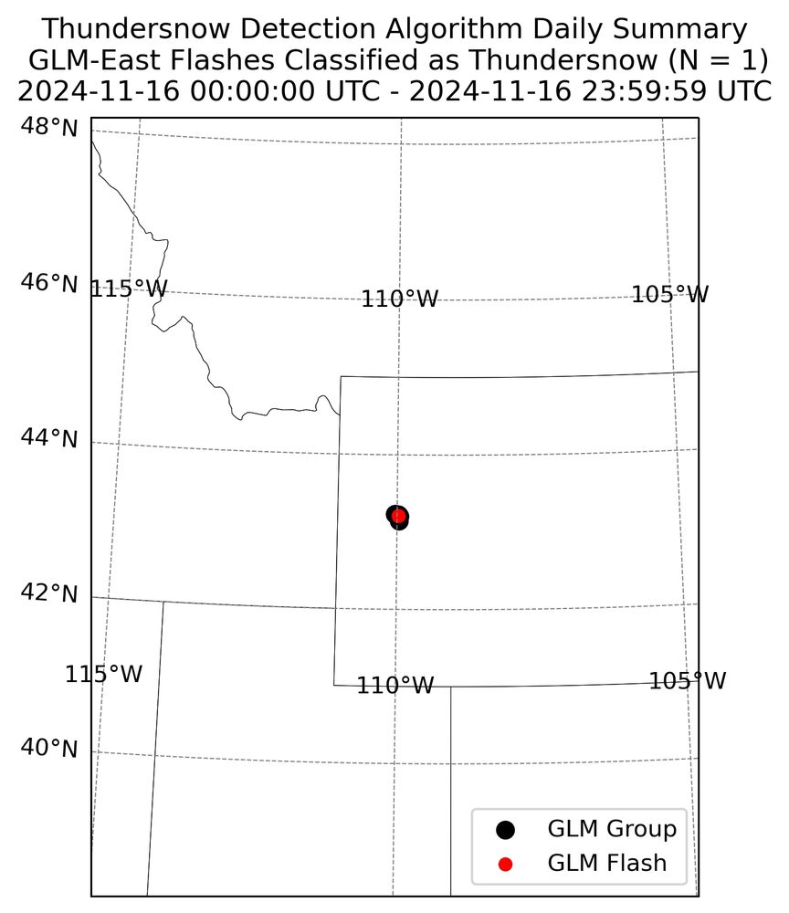
Geographic map of a single thundersnow flash in Wyoming on 16 November 2024.
Yesterday, a single thundersnow flash occurred in Wyoming. That's still one more than I've observed... #WYwx
17.11.2024 16:41 — 👍 0 🔁 0 💬 0 📌 0
Thank you! Currently, my algorithm runs internally. But I'm pushing these summary plots to a public facing server. I'll DM you the link if you're interested. Otherwise, I plan to continue posting the summary plots here everyday.
17.11.2024 02:44 — 👍 2 🔁 0 💬 1 📌 0

Geographic map of thundersnow detected on 15 November 2024.
Looks like California and Nevada observed the most thundersnow yesterday. #CAwx #NVwx
16.11.2024 23:38 — 👍 3 🔁 0 💬 1 📌 0
Post a picture you took (no description) to bring some zen to the timeline.
16.11.2024 20:52 — 👍 0 🔁 0 💬 0 📌 0
Welcome to Bluesky! #LGRW
16.11.2024 01:04 — 👍 0 🔁 0 💬 0 📌 0
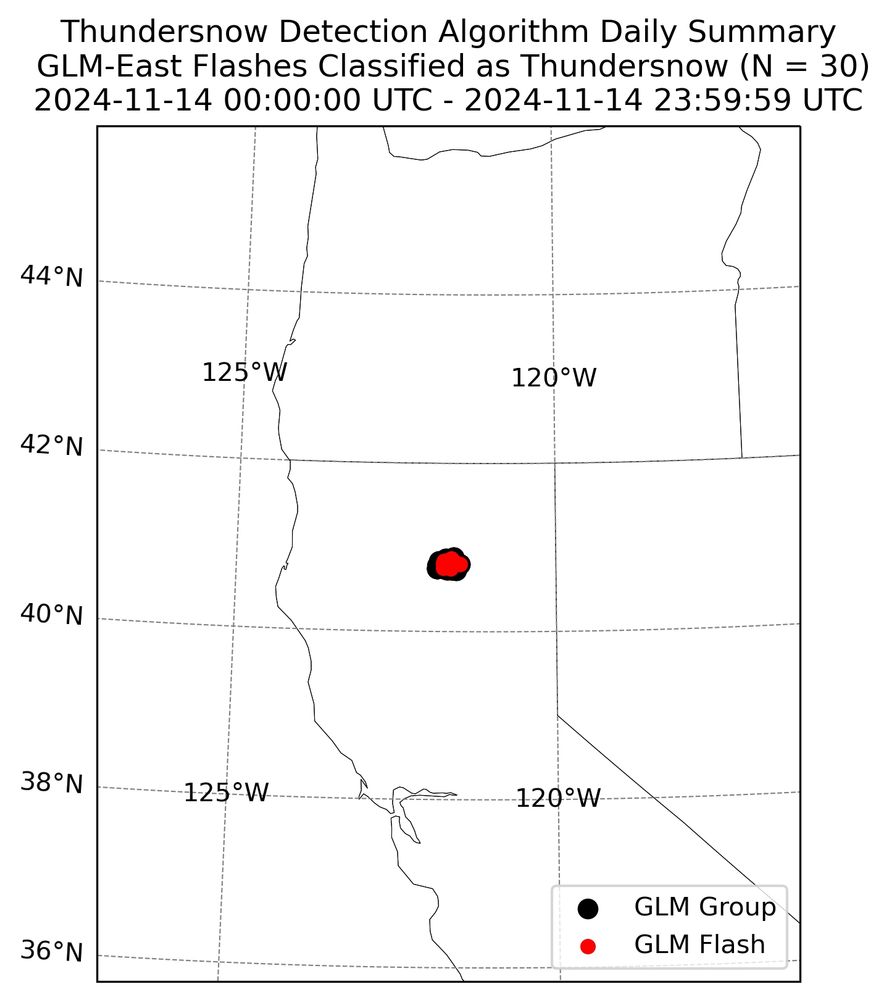
Geogeqphic map of thundersnow observed on 14 Nov 2024.
Yesterday, GLM detected 30 thundersnow flashes in Northern California in a relatively small area. #CAwx 🧪
15.11.2024 23:36 — 👍 2 🔁 0 💬 0 📌 0

Geographic map of thundersnow that occurred on 13 November 2024.
Daily thundersnow summary for 13 November 2024. It looks like Colorado was the winner. 🧪
14.11.2024 22:56 — 👍 1 🔁 0 💬 1 📌 0
Apollo 12 is one of the reasons we have the lightning detection capabilities we do.
After the rocket was struck and "Flight, try SCE to AUX", a lot of research was focused on forecasting and detecting lightning.
Now we detect more than 2 billion lightning events around the world each year. 🧪
14.11.2024 14:14 — 👍 68 🔁 23 💬 2 📌 0

Map of thundersnow flashes observed from GLM-East within continental United States on 12 Nov 2024.
Thundersnow flashes that GLM-East observed on 12 November 2024. These flashes were classified by an algorithm that I developed as part of my masters thesis (6 years ago). Going forward, I'll be posting daily summary maps similar to this.
13.11.2024 21:37 — 👍 3 🔁 0 💬 0 📌 0
It's 6:45a, and my polling place has a line halfway around the building already. I've never seen anything like this before in Huntsville, AL! #YourVoteMatters
05.11.2024 12:45 — 👍 1 🔁 0 💬 0 📌 0
My thoughts on the Lions/Packers game so far: What if this rain was snow instead?
03.11.2024 22:42 — 👍 2 🔁 0 💬 0 📌 0
Some things can beat it, but updated code working flawlessly the first time is pretty high up on my feels good list.
23.10.2024 22:33 — 👍 1 🔁 0 💬 0 📌 0
Finally made the switch #wxtwitter! Lightning, thundersnow, and winter weather are my research passions. Yet, I'm warming up to sea surface temperatures and oceanography.
19.10.2024 22:22 — 👍 4 🔁 0 💬 0 📌 0
NWS meteorologist, UIUC & UNL alum, opinions are my own. Photographer and runner in my free time, and am often thinking about football
* Christian; Husband; Dad
* SPC Chief of Science & Support
* OBU Assistant Professor of Natural Science
* Former Bear poker turned Bear
Owner of MSW Media, host of The Daily Beans, UnJustified, and Cleanup on Aisle 45 podcasts. #Leguminati. Veteran. She/Her Substack: muellershewrote.com Secure contact: FedOath@pm.me
Signal: muellershewrote.23
Podcast: https://link.chtbl.com/TheDailyBeans
NSF Unidata Program Center. NSF Unidata exists to serve a community of researchers and educators dedicated to advancing the frontiers of Earth Systems science with data access, tools (e.g. NetCDF, AWIPS, IDV, MetPy, THREDDS, LDM), and community support.
Warning Coordination Meteorologist at National Weather Service Milwaukee. Youth Hockey Coach. Sieve of a goalie.
Official Bluesky Home of the 11x Stanley Cup Champions • Presented by: @LittleCaesars • #LGRW
The National Weather Association is a member-led professional association supporting and promoting excellence in operational meteorology and weather related activities.
Official Bluesky account for NOAA's National Weather Service.
Atmospheric Scientist. Assistant Prof at the University of Wisconsin-Madison. Subseasonal to seasonal variability, tropical-extratropical interactions, MJO, climate dynamics, and blocking. Opinions are my own.
https://stephanieahenderson.weebly.com/
The UNOFFICIAL Bluesky of your 11x Stanley Cup Champions • Celebrating 100 years of Hockeytown • #LGRW
NOT AFFILIATED with the team. Mostly transcribing posts from their X account to here. No copyright intended.
Manually operated by @k1yrix.and.cat
"You cannot escape the responsibility of tomorrow by evading it today.” – Abraham Lincoln 🏴☠️ | Home of #TheBreakdown and LP Podcast
Atmospheric Science Professor. Interested in all things clouds and storms using data science, modeling, and observations. tobac core team. Views mine, not my employer’s.
Assistant Professor // University of North Dakota Atmospheric Sciences
M.S. & PhD // Texas A&M
B.S. // UAH
Detroit Red Wings, NHL, & hockey podcast hosted by @RyanHanaWWP.bsky.social, @BradKrysko.bsky.social, & @HockeytownEvan.bsky.social. 🎙️ #1 Red Wings podcast worldwide 🌎 7 million+ downloads! #LGRW
Iowa Environmental Mesonet https://mesonet.agron.iastate.edu ,
Father of all the IEMBots here,
https://github.com/akrherz
Signal >> Noise, hopefully.
AGU is a global community supporting more than half a million advocates and professionals in Earth and space sciences.
Atmosphere-ocean-cryosphere; Extreme events; Teleconnections; 🌪️🌀❄️🇲🇽🇨🇱🇧🇧🇦🇹
PhD OU; Full Prof Oceanography USNA; Prog Officer AFOSF; CCM; Fulbright scholar; Bilingüe
Mondays at 9pmET on MSNBC
MaddowBlog.com
Andrew Young: The Dirty Work: MSNBC.com/Andrew-Young-The-Dirty-Work
From Russia with Lev: MSNBC.com/Lev
Ultra podcast: MSNBC.com/Ultra
Prequel: MSNBC.com/Prequel