Digitaalisilla jalanjäljllä ymmärrystä puistojen ja luontoalueiden käytöstä -tapahtumaa mainostava juliste. Tapahtuma 11.2.2026, klo 13–15 Tiedekulmassa Helsingissä.
Vielä ehtii 🚨 Ensi keskiviikkona 11.2. klo 13–15 Tiedekulmassa huippututkimusta ja huippukeskustelua luonnon virkistyskäytöstä, kävijäseurannasta ja digitaalisista jalanjäljistä. Lopuksi pullakahvit!
Ilmoittautumislinkki -> www.lyyti.fi/reg/Digitaal...
05.02.2026 07:05 — 👍 1 🔁 0 💬 0 📌 0


Spencer Wood from the Outdoor Recreation & Data Lab at the University of Washington (UW) joins DGL as a visiting fellow this academic spring term 👋
Thank you to the University of Helsinki to supporting this visit through the 2025 US Visiting Fellowship Programme!!
Welcome to DGL Spencer ❤️.
29.01.2026 13:49 — 👍 1 🔁 0 💬 0 📌 1

✨We're growing!! ✨
🎓 Researcher Juulia Lehtinen has rejoined DGL to pursue Doctoral Research under the supervision of Tuuli Toivonen as part of the GREENTRAVEL project.
Learn more about Juulia's work here: blogs.helsinki.fi/digital-geog...
Welcome Juulia!! ❤️ 🎉
23.01.2026 14:05 — 👍 2 🔁 0 💬 0 📌 0

Digitaaliset jalanjäljet tarjoavat uusia mahdollisuuksia tuottaa ajantasaista ja monipuolista tietoa luonnon virkistyskäytöstä.
Tule kuulemaan ja keskustelemaan aiheesta tapahtumassamme!
📅 ke 11.2.2026
📍 Tiedekulma
🔗 Lue lisää: tapahtumat.helsinki.fi/fi-FI/page/6...
14.01.2026 09:52 — 👍 1 🔁 1 💬 0 📌 0
Big data and the use of Helsinki’s urban green areas – Findings of a joint research project – Digital Geography Lab blog
What do big data tell about the use of urban green areas in Helsinki? Check out our blog post for a summary of our findings in English!
blogs.helsinki.fi/digital-geog...
#bigdata #gis #greenspace #Helsinki
09.01.2026 10:39 — 👍 0 🔁 0 💬 0 📌 0

Screenshot of a web map. Uutela outdoor recreation area and its green space card is clicked open.
Tuotimme myös 50:stä eniten havaintoja keränneestä viheralueesta ’kortteja’. Kurkkaa tästä kartasta, miltä esim. Keskuspuisto ja Mustikkamaa näyttävät massadatojen näkökulmasta: digitalgeographylab.github.io/Helsingin-ka...
09.01.2026 10:33 — 👍 0 🔁 0 💬 1 📌 0

Kuvakaappaus hankkeen loppuraportin kannesta, lukee "Viheralueiden käyttö Helsingissä". Kuvassa Töölönlahti kesällä.
Mikä on Helsingin sometetuin viheralue? Missä lenkkeillään, mistä otetaan lintukuvia? Missä käydään ympäri vuoden ja mitkä ovat kesäkohteita? Mm. näitä sivusimme yhteishankkeessamme massadatoista ja Helsingin viheralueiden käytöstä. Lisää tietoa blogistamme! blogs.helsinki.fi/digital-geog...
09.01.2026 10:33 — 👍 3 🔁 2 💬 1 📌 0
#30DayMapChallenge Day 28 - Black Friday
Black Friday or Bird Friday?
We think that birdwatching is better than impulsive shopping - even in November.
Our map shows the 1512 observations in Finland that eBird users have posted over the past Black Fridays (2015-2024).
@matabatchi & Sini Ruohomäki
28.11.2025 15:11 — 👍 11 🔁 2 💬 0 📌 0

Together with Metsähallitus Parks and Wildlife Services we propose operationalizing the use of mobile big data for visitor monitoring and the management of outdoor recreation.
Read more from our blog post: lnkd.in/dGYn2gvW
24.11.2025 11:47 — 👍 3 🔁 1 💬 0 📌 0

#30DayMapChallenge Day 20 - Water: An Australian River Alphabet
Inspired by Katie Holten's Irish Tree Alphabet 🌳
Unsure of any Australian river names beginning with 'X' and 'Z'.
River centrelines: www.hydrosheds.org
River catchments: ecat.ga.gov.au/geonetwork/s...
(c) Rory Taylor
20.11.2025 09:23 — 👍 18 🔁 1 💬 0 📌 1

📢 GREENTRAVEL Virtual Reality Technical Report Released!
📄Read more here: blogs.helsinki.fi/digital-geog...
📖 Check the report out here: helda.helsinki.fi/items/395be1...
#UrbanResearch #VirtualReality #ActiveTravel #SmartCities #StreetGreenery
17.11.2025 14:05 — 👍 1 🔁 1 💬 0 📌 0
We also made a new tool!
Play around on this interactive demo webmap over all of Helsinki: tadusko.github.io/hki_shademap/
17.11.2025 06:30 — 👍 1 🔁 0 💬 0 📌 0

A map of Helsinki's urban core. It shows which areas are in the shade on a clear day in mid-June. Hietaranta beach and Töölönlahti bay are highlighted with photos, since they are have some of the sunniest spots on the map.
#30daymapchallenge 17: A new tool
Helsinki enjoyed a grand total of 12 minutes of sunshine in November (1.–13.11). No better time to remember that yes, the sun does still exists.
This map shows Helsinki's shadiest / sunniest places. New tool? #GRASSGIS solar modelling.
By @tadusko.bsky.social
17.11.2025 06:30 — 👍 13 🔁 5 💬 2 📌 0

#30DayMapChallenge Day 10 - Air: Common Swift (Apus Apus) sightings in Finland in 2025 from eBird (+one Taylor Swift (Private Jet))
10.11.2025 16:13 — 👍 13 🔁 3 💬 1 📌 0

#30DayMapChallenge Day 4 - My Data
The 2025 citybike season in Helsinki has come to an end last week. As an avid user of the bike sharing system, Robert Klein has plotted his more than 350 trips of this year's season on a map.
#bikesharing #cycling #mobility
04.11.2025 13:50 — 👍 9 🔁 1 💬 0 📌 0

#30DayMapChallenge Day 1 - Points
Creating a #centroid is not as trivial as you might think!
If you are dealing with regional population data, the locational difference between a regular geometric centroid and a population-weighted centroid can be vast!
Map by @waeiski.bsky.social
#GIS #QGIS
01.11.2025 15:25 — 👍 18 🔁 3 💬 1 📌 0

Project planner to The Digital Geography Lab
Project planner to The Digital Geography Lab
📢 Come join us!! We are looking for a project planner to coordinate our new UrbanISE VR Proof of Concept, funded by @erc.europa.eu and based at the @helsinki.fi.
🏙️ Work at the forefront of applied Virtual Reality research in cities!
📝 Read more and apply here: jobs.helsinki.fi/job/Helsinki...
30.10.2025 14:08 — 👍 2 🔁 0 💬 0 📌 0

Our collaboration with Metsähallitus is moving ahead even more efficiently and with greater impact as we have signed MoU with Metsähallitus Parks & Wildlife Finland to deepen our research cooperation and streamline the two-way sharing of data and knowledge.
blogs.helsinki.fi/digital-geog...
27.10.2025 10:09 — 👍 6 🔁 3 💬 0 📌 0
What are digital footprints and how can they be useful for managers of nature recreation areas? In this video, researchers from the Digital Geography Lab, University of Helsinki, explain how digital…
Mobile Big Data For Understanding People in Nature
Do you ever use your mobile phone when spending time outdoors?
The answer is probably yes. In that case, you leave digital footprints about your visit. 🦶
How are these data useful for the sustainable management of nature areas?
👉 Watch our video for that and more! www.youtube.com/watch?v=_U5G...
21.10.2025 13:03 — 👍 3 🔁 2 💬 0 📌 0
In our new @ijgis.bsky.social paper, @ollejarv.bsky.social and I analysed 9M geolocated tweets from the Greater Region of Luxembourg within the #BORDERSPACE project at the @digigeolab.bsky.social, funded by the Research Council of Finland and @koneensaatio.fi.
18.09.2025 09:29 — 👍 1 🔁 1 💬 1 📌 0

Our lab is growing! We're super happy to introduce Anna Saarinen, who joins DGL to support coordination and management of the Geoportti Research Infrastructure!! 🌟
Learn more about Anna here 👉 👉 blogs.helsinki.fi/digital-geog....
Welcome Anna! We're very excited to be working with you 💚
10.09.2025 06:14 — 👍 1 🔁 0 💬 0 📌 0
Hei #sinitaivas tarvitsemme osanottajia tulevaan työpajaamme!
Jos aluekehitys, aluepolitiikka ja muuttoliikkeet kiinnostavat etenkin kun kyseessä on #Suomi ja tarkemmin itäiset ja pohjoiset osat, niin mukaan vaan!
#Finland #Finnish #Region #Europe #EU
04.09.2025 14:10 — 👍 1 🔁 2 💬 0 📌 0

English: A map of Europe and its NUTS 2 regions with Eastern and Northern Finland highlighted. At the bottom there are the logos of Mobi-Twin research project and the European Union.
Suomeksi: Kartta Euroopasta NUTS 2 -alueineen ja Itä- ja Pohjois-Suomen alue on korostettuna. Alareunassa on Mobi-Twin -tutkimushankkeen ja Euroopan Unionin logot.
Hei sinä Itä- tai Pohjois-Suomalainen!
Kiinnostaako sinua kotiseutusi aluekehitys ja tulevaisuus? Tule mukaan työpajaamme!
🗓️ Syyskuun 12. päivä 2025
⏰ Kello 11:00 – 12:30
Osallistumistiedot blogissamme:
blogs.helsinki.fi/digital-geog...
#Savo #Lappi #Kainuu #Alue #Tulevaisuus #Mikkeli
04.09.2025 12:34 — 👍 6 🔁 2 💬 0 📌 1

Olle explaining how to delineate functional border regions using mobile big data and kernel density estimation.
Wrapping up the second day of #ERSA2025 we have @ollejarv.bsky.social from @digigeolab.bsky.social presenting his work on using #BigData describing #mobility of people to assess #CrossBorder integration in #Europe.
28.08.2025 13:49 — 👍 3 🔁 1 💬 0 📌 0

Summer in Helsinki always brings smiles to our faces, as do the scholars that visit and collaborate with us 😊 We're thrilled to introduce Francesc Comalada, a PhD Researcher who visits us this autumn from the Catalan Institute of Water Research!
Learn more here 👉 blogs.helsinki.fi/digital-geog...
13.08.2025 13:38 — 👍 1 🔁 0 💬 0 📌 0
Our open course on #cartography and #GIS was run for the second year. Kamyar reflects back on this year and the course principles: how we focus not (only) on building technical capabilities, but on maps as means of visual storytelling:
Read more here! blogs.helsinki.fi/digital-geog...
06.08.2025 11:27 — 👍 6 🔁 2 💬 1 📌 0
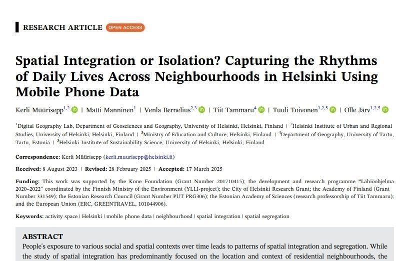
📢 New Paper Out! Led by our very own Kerli Müürisepp 👉 “Spatial Integration or Isolation? Capturing the Rhythms of Daily Lives Across Neighbourhoods in Helsinki Using Mobile Phone Data” in Population, Space and Place!
📄 Read the open access article here: doi.org/10.1002/psp....!
04.06.2025 11:27 — 👍 5 🔁 1 💬 0 📌 0
data, policy | impact entrepreneur | covering soil and landscape‑scale agrobiodiversity
co-founder of data network https://hinterland.systems/
registering an 🇪🇺 data altruism organisation for land use data
Open-source geoinformation, methods and software for the benefit of the environment and society.
---
This is the official account of HeiGIT (Heidelberg Institute for Geoinformation Technology) at Heidelberg University.
Check us out at https://heigit.org/
Activities and latest publications of researchers at the Department of Geography @unibonn.bsky.social
Research profile and focuses: http://bit.ly/2JtH4JU
art & architectural historian / visual, material & religious culture
Associate Prof. in Computer Science / Maître de conférences en informatique, Université de Lille
Data analyst/scientist making data analysis software, #datavis, #datascience , etc, nature photography, some creativity and hobbyist personal complex medical research . ( Did I miss anything?... well, #mecfs ;)
miskaknapek.eu
MOBI-TWIN focus on analysing the factors that shape human mobility behaviour, taking into account the influence of Twin Transitions on regional attractiveness.
🌐 https://mobi-twin-project.eu
Horizon Europe Project | Grant Agreement no. 10109440
Tilastokeskus yhdistää tietoaineistot ja asiantuntemuksen tilastoiksi ja tietopalveluiksi.
The 6th British Ecological Society journal, publishing work on relationships between people and nature. EiC Kevin Gaston, posts by Assistant Editor Milly and Publishing Assistant Anna.
🌎 #Sociologist without #borders. Professor of ILAESP. Executive Board of @CLACSO. Regional Editor at Journal of Borderlands Studies (LATAM) #Geopolitics
Unsweetened Black Tea ☕️ or Mate 🧉
Geography PhD student at University of Oxford researching digital mediations of rivers
Historian. Uni of Exeter. Off White. Central and Eastern Europe and the Global History of Race (2024); Socialism Goes Global (2022)
https://arch-history.exeter.ac.uk/history/profile/index.php?username=jamark
Professor, Dep. Geography
Universidade Federal do Amazonas
Brazil
#Amazon #RemoteSensing #Cartography #Rivers #Climate
Web development, data management and visualizations. Consulting services for scientific and r&d communities. https://www.researchelements.org/
Co-Creating Ireland's Public Involvement in Open Research Roadmap
ENGAGED is building a national roadmap to shape public involvement in open research in Ireland. We believe that research can and does play an important role in tackling societal challenges.
The IT Center is an independent unit at the University of Helsinki, serving as a centralised hub for the University’s shared IT services.
Website: https://helsinki.fi/it
Support: http://helsinki.fi/helpdesk
📚Leading international scholarly association on borders & borderlands
📆 Next annual meeting: March 25-28, 2026 in Albuquerque, NM
https://absborderlands.org/
South West Edinburgh 20 Minute Neighbourhoods
📍#Edinburgh
Positive, sustainable changes. Live well locally. #streetsNOTroads
🚲FREE e-bike & e-cargobike hire: sw20.info
🛠️Tool Library: @sw20etl
🏃♀️Helped setup: Kids Park Run @ Hailes Quarry Park